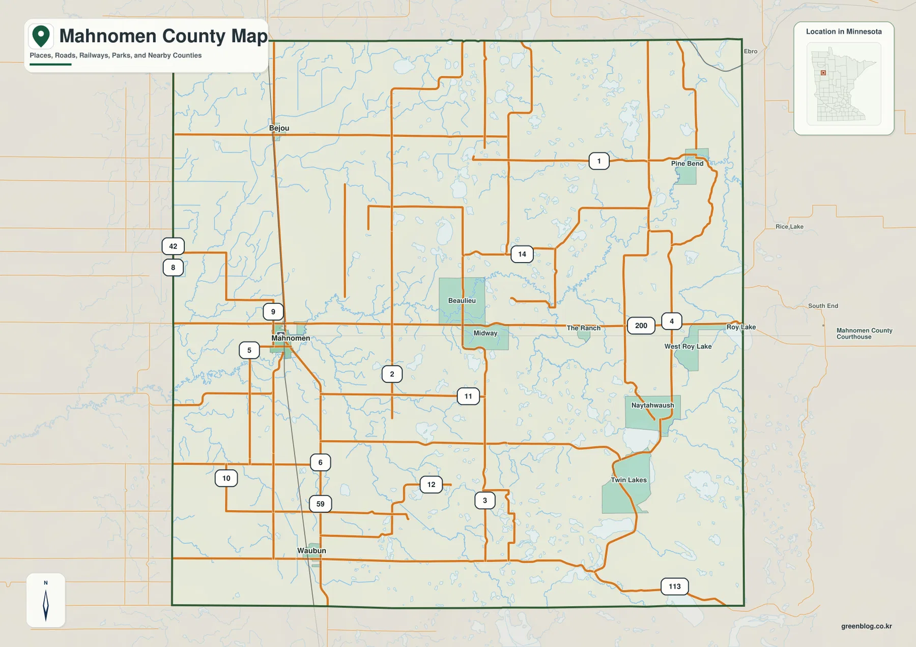
Mahnomen County sits in northwestern Minnesota, where the communities of Mahnomen, Waubun, and Bejou provide clear reference points for reading the county. This page brings together the county boundary, road network, city connections, rivers and lakes, and local relief, and the supplied maps are also available as high-resolution A3 JPG files in a downloadable ZIP.
The county has an unusual geographic setting because all of Mahnomen County lies within the exterior boundaries of the White Earth Reservation. That background matters when looking at the map: the county is not simply a grid of roads and towns, but a place where county communities, White Earth Nation, river corridors, lake country, and rural land all overlap. The map set is most useful when these elements are read together rather than as separate facts.
Table of Contents
A Minnesota county entirely within White Earth Reservation
U.S. Census Bureau QuickFacts lists 557.87 square miles of land in Mahnomen County for 2020. The 2020 Census counted 5,411 residents, while the July 1, 2025 estimate is 5,153. Those figures make it a lightly populated county by Minnesota standards, and the maps reflect that rural character: communities are separated by broad areas of roads, streams, lakes, wetlands, and open land rather than by one continuous urban corridor.
White Earth Nation materials and Minnesota state sources describe the entire county as lying inside the White Earth Reservation. Reservation boundaries should not be confused with a single pattern of land ownership, because land within those boundaries can be held in different forms. For ordinary map reading, the key point is that Mahnomen County and the reservation occupy the same broad geographic space here, making White Earth history and present-day institutions important context for understanding the county.
Minnesota statutes record Mahnomen as a county formed by popular vote in 1906. Mahnomen is the county seat and the principal map reference, with Waubun to the south and Bejou to the north. The name Mahnomen is closely associated with wild rice in regional history, a connection that also feels appropriate on a map where the Wild Rice River is one of the most prominent named waterways.
Reading Mahnomen, Waubun, Bejou, and the road network
The county map places Mahnomen in the western half of the county where several numbered roads meet. U.S. 59 forms the clearest north-south reference through Mahnomen and continues toward Waubun, while Minnesota 200 provides a strong east-west reference across the middle of the county. Once those two roads are located, it becomes much easier to orient places farther east, including Naytahwaush, Roy Lake, West Roy Lake, and Twin Lakes.
Waubun appears south of Mahnomen along the U.S. 59 corridor, and Bejou is positioned farther north. The larger county map also labels Beaulieu, Midway, The Ranch, Pine Bend, Roy Lake, Naytahwaush, and other smaller places. These names make the map more useful than a simple three-city diagram because they help connect local roads to communities that would otherwise be difficult to place.
The road pattern also changes across the county. The western and central sections show a relatively regular network of numbered routes, while the eastern side is broken up by more lakes, creeks, and curving local connections. A driver looking for general orientation can begin with U.S. 59 and Minnesota 200, then move to the smaller numbered roads near the destination. Someone studying natural features may do the opposite, starting with the rivers and lake names before checking the nearest road.
A simpler city-connection view
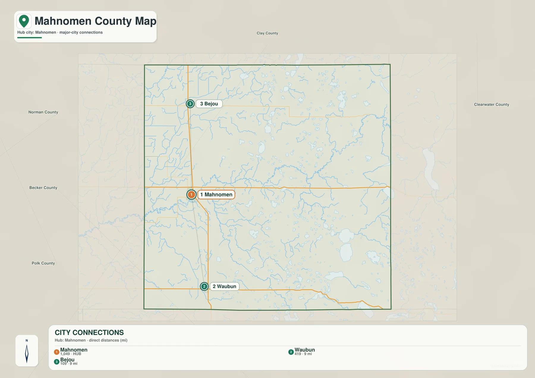
The city-connection map strips away much of the detail and gives Mahnomen, Waubun, and Bejou visual priority. Mahnomen serves as the hub in the middle, Waubun sits to the south, and Bejou is to the north. This is a useful starting map for readers who have never seen the county before because it shows the settlement pattern without making them sort through every road number and small community label.
Neighboring counties are also named around the frame, including Becker, Norman, Polk, Clay, and Clearwater counties. Their labels help place Mahnomen County within northwestern Minnesota rather than presenting it as an isolated rectangle. For a classroom slide, regional report, or quick travel reference, this reduced view can communicate the county’s position faster than the more detailed road map.
The simplified map should not be treated as a complete picture of settlement, however. Communities such as Naytahwaush and the Roy Lake area are important in the eastern part of the county even though the three-city view emphasizes the incorporated places along the western side. Using the city map together with the full county map prevents that simplification from becoming misleading.
Wild Rice River, White Earth River, and the eastern lakes
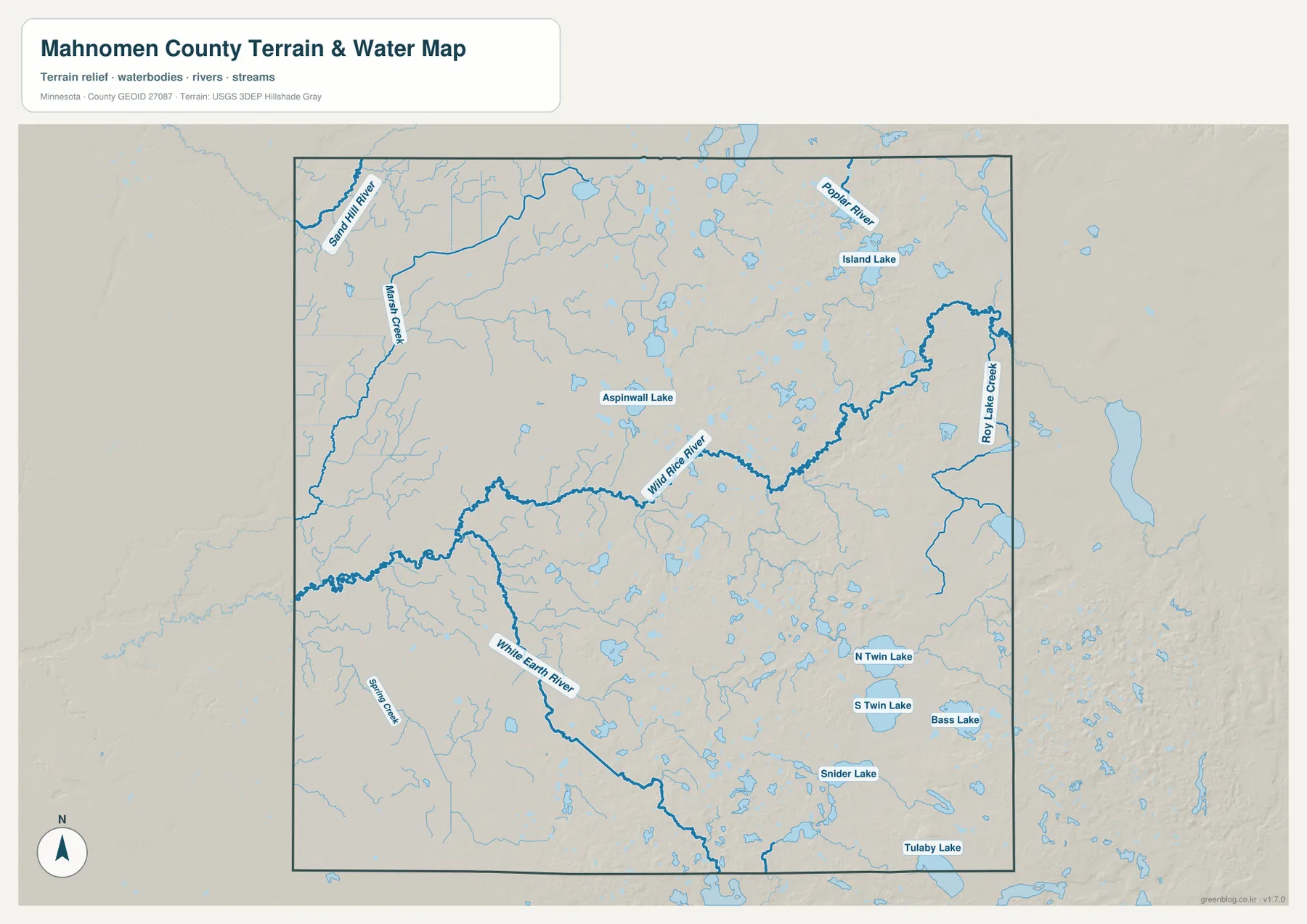
The water map changes the emphasis completely. Wild Rice River becomes the dominant central feature, bending across the county and receiving smaller streams along the way. White Earth River is labeled across the southern part of the map, while Poplar River and Roy Lake Creek appear in the northeast. Marsh Creek and Spring Creek add smaller named drainage features on the western side.
Lakes are more conspicuous toward the east and southeast. The map labels Island Lake, Aspinwall Lake, North Twin Lake, South Twin Lake, Bass Lake, Snider Lake, and Tulaby Lake. These are selected labels rather than a complete inventory of every water body, but together they show why the eastern half of Mahnomen County looks much more water-rich than it does on a road-only map.
Comparing the Wild Rice River with the White Earth River is especially helpful for orientation. The first provides a broad central reference, while the second traces a more southerly course. The named lakes then give the eastern side a second layer of landmarks. Readers planning fishing, shoreline access, or detailed hydrologic work should still consult official USGS or White Earth Nation resources, because this map is designed as a county reference rather than a navigation or water-management product.
Relief rises from the west toward the east
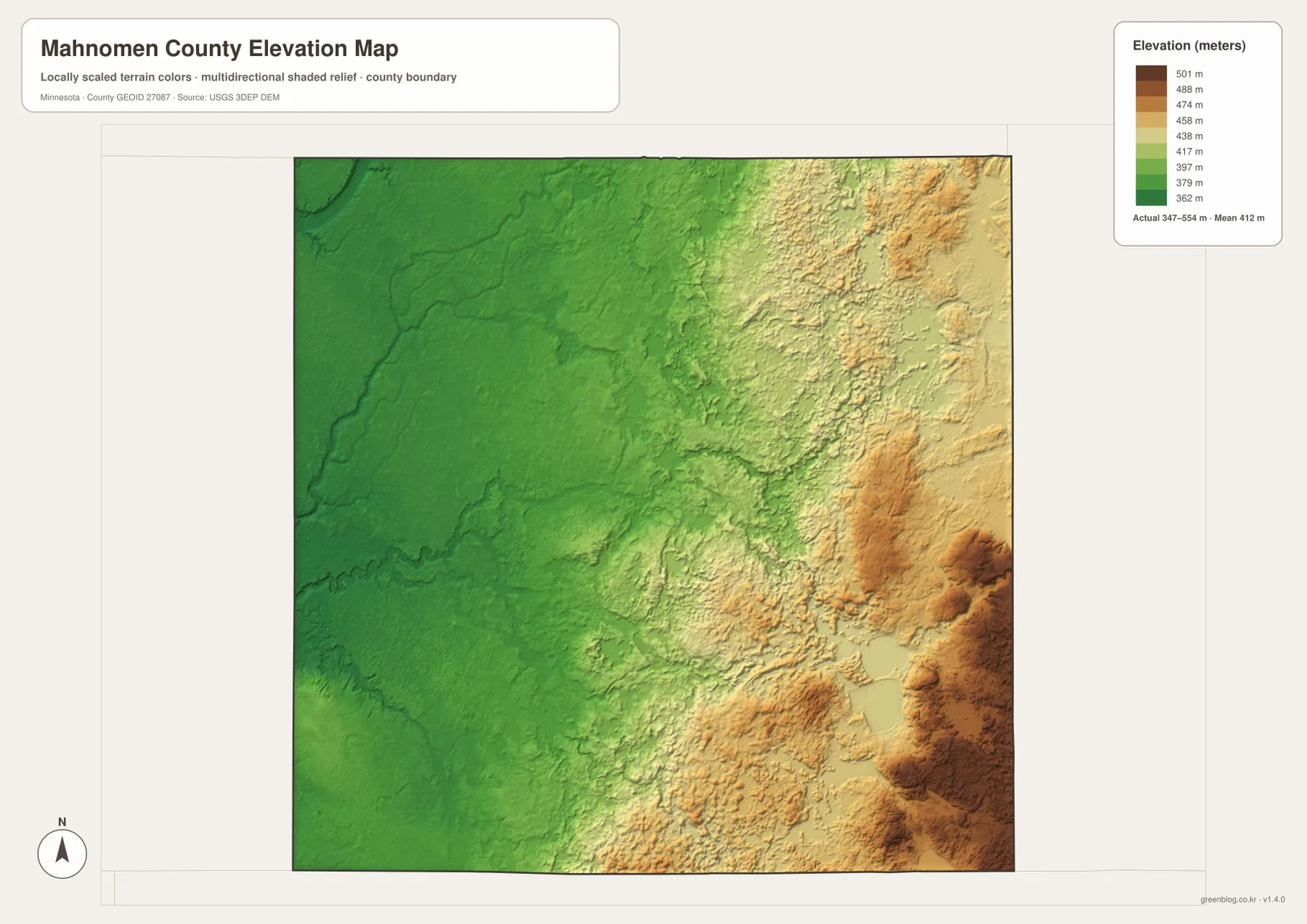
The elevation map shows a broad west-to-east change that is easy to miss on the road map. Its legend gives an actual county range of about 347 to 554 meters, with a mean near 412 meters. Darker greens dominate much of the western half, indicating lower ground, while yellow, tan, and brown areas become more common toward the east where the terrain rises and becomes more varied.
The strongest high-relief colors appear in parts of the eastern and southeastern side. Small ridges and rounded higher areas stand out against the smoother western lowlands. When the elevation and water maps are viewed together, the lake-rich east can be seen in a more varied terrain setting, while the western side has broader stretches of lower ground crossed by streams and roads.
The colors are locally scaled for Mahnomen County, which is an important detail. A dark brown area on this map should not be assumed to have the same elevation as the same color on another county map. Direct comparisons require the numeric legend or an external elevation dataset. For engineering, surveying, or precise height measurements, the USGS 3D Elevation Program is a more appropriate source.
Choosing the right file for the task
For general orientation, the full county map is the most useful first choice because it combines community names, roads, the county outline, and nearby context. The city-connection map is better when the goal is to explain where Mahnomen, Waubun, and Bejou sit relative to one another without the distraction of many smaller labels. It works particularly well in presentations and introductory classroom material.
The water map is the better reference for Wild Rice River, White Earth River, the Twin Lakes area, and other named water features. It can be paired with the elevation map when a report needs to show how waterways and terrain relate. The elevation file is less useful for finding a road address, but much better for seeing the broad rise from the lower western side to the higher eastern side.
All supplied files are high-resolution A3 JPG images, so they can be printed at a useful size or reduced for reports and slides. A practical workflow is to use the county map as the overview, add the water map when discussing rivers and lakes, and bring in the elevation map only when topography matters. That keeps each page readable instead of forcing road, water, and terrain information into one crowded graphic.
Limits of the map set
These maps are intended for general county reference. They are not legal property maps, emergency routing maps, flood-hazard products, or authoritative statements of jurisdiction. That distinction is especially important in a county that lies within White Earth Reservation, where reservation boundaries, county administration, and land ownership are not the same thing. Official county, tribal, state, and federal sources should be used when a decision depends on legal or current operational information.
The water map also labels selected rivers, creeks, and lakes rather than every wetland or minor channel, and the elevation map summarizes terrain visually instead of providing survey-grade measurements. Used with those limits in mind, the files work well together: one explains settlement and roads, another simplifies the main city relationship, a third brings the water network forward, and the last shows how the ground rises across the county.
Frequently Asked Questions
Which map is easiest for locating Mahnomen, Waubun, and Bejou?
The city-connection map is the simplest option because it gives those three places priority and removes much of the smaller road detail. Use the full county map as the next step when you need numbered roads, eastern communities, or more local context.
Where can I see the Wild Rice River and White Earth River most clearly?
The water map is designed for that purpose. It labels both rivers and also shows Poplar River, Roy Lake Creek, several smaller streams, and named lakes including North Twin Lake, South Twin Lake, Bass Lake, and Snider Lake.
Can the elevation colors be compared directly with another Minnesota county map?
Not reliably by color alone. The terrain colors are locally scaled to the Mahnomen County elevation range, so comparisons with another county should use the numeric legend or an external elevation dataset rather than matching colors visually.
Map File Information
The Mahnomen County download includes the county reference map, city-connection map, water map, and elevation map as high-resolution A3 JPG files.
- Included Files: County map, city-connection map, water map, elevation map
- Printable Size: High-resolution A3
- File Type: JPG
Related Maps
Sources and reference data
- U.S. Census Bureau QuickFacts – Mahnomen County, Minnesota for population and land-area statistics.
- White Earth Nation – White Earth Resources for reservation geography and regional background.
- Minnesota Revisor of Statutes – Section 2.01 for the county formation record.
- U.S. Census Bureau TIGER/Line for official boundary and geographic reference data.
- USGS National Hydrography for rivers, lakes, and hydrographic data.
- USGS 3D Elevation Program for elevation and terrain data.
Green Map creates custom-edited map images using open geographic data sources such as geoBoundaries, Natural Earth, OpenStreetMap, and government open data. These maps are edited visual materials, not raw data files, and are provided for education, documents, presentations, and graphic reference.