Harlan County sits in south-central Nebraska where a broad Republican River valley, Harlan County Lake, and a network of narrow tributary valleys create a landscape that changes noticeably from south to north. Alma is the main reference point on the maps, while Orleans, Stamford, Republican City, Huntley, and Ragan spread across the county in a pattern that makes more sense when roads, water, and relief are viewed together. The high-resolution JPG versions of all four maps can be downloaded from the file box later on this page. High-resolution map files are available for download in the section below.
The southern part of the county is visually anchored by the Republican River and the reservoir. Low ground follows that water corridor past Orleans toward Alma and then broadens around Harlan County Lake. Farther north, the surface rises into rolling uplands cut by many small creek valleys. That contrast is the most useful theme for reading this map set because it links the location of communities with the county’s drainage and elevation.
Table of Contents
Start with Alma, Orleans, and the southern settlement corridor
The general county map is the best orientation map because it keeps communities, numbered roads, county boundaries, and water features in the same frame. Alma appears just northwest of Harlan County Lake, with Orleans to the west and Stamford farther west along the southern half of the county. Republican City is east of Alma near the lake, while Huntley and Ragan sit well to the north. This arrangement immediately separates a cluster of southern communities from the more dispersed northern settlements.
Alma is also the county seat. Nebraska government material and the official Harlan County website identify Alma as the location of county government, which fits its central role on the map. Several labeled roads converge in or near the community, making Alma a practical reference point for comparing the western river towns, the reservoir area, and the northern interior of the county.
Oxford deserves a careful reading because it appears near the western county edge rather than in the six-place city index. Nebraska’s Blue Book notes that Oxford lies in both Furnas and Harlan counties. That is a useful reminder that a community label near a county line may represent a place that crosses the boundary, so the map should not be read as though every town were entirely contained on one side of a line.
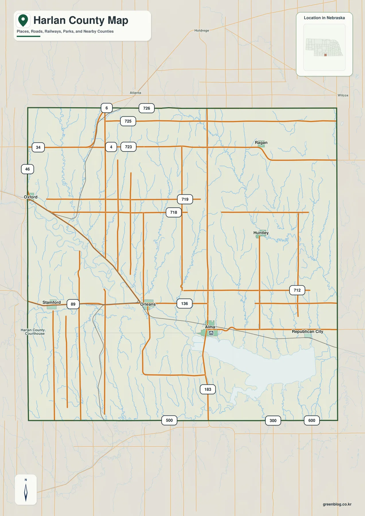
Use this map as the base reference before turning to the more specialized sheets. It is especially helpful for seeing how Alma relates to Orleans and Stamford to the west, how Republican City relates to the lake, and how Huntley and Ragan occupy a separate northern zone. Nearby labels outside the boundary, including places toward Holdrege and Wilcox, help establish direction without turning the sheet into a full regional road map.
The six-place city index reveals a strongly southern pattern
The city location sheet simplifies the county by emphasizing six communities and ranking them in the inset index. Alma is listed first, followed by Orleans, Stamford, Republican City, Huntley, and Ragan. The ranking is a compact way to distinguish the mapped settlements; it should not be interpreted as a road hierarchy or as a legal classification of cities and villages.
Four of the six highlighted places—Alma, Orleans, Stamford, and Republican City—sit in the southern half of the county, close to the Republican River corridor or Harlan County Lake. Huntley and Ragan are farther north, separated from that cluster by a broad rural interior. The pattern helps explain why the southern road network appears more closely associated with named communities while the northern half is dominated visually by drainage lines and open upland terrain.
The official county website lists seven cities and villages associated with Harlan County: Alma, Huntley, Orleans, Oxford, Ragan, Republican City, and Stamford. Because the supplied city sheet highlights only six, it is best treated as a settlement-distribution graphic rather than a complete legal municipal inventory. Oxford’s cross-county location helps explain why a simplified ranking map and an official administrative list do not necessarily contain exactly the same set of labels.
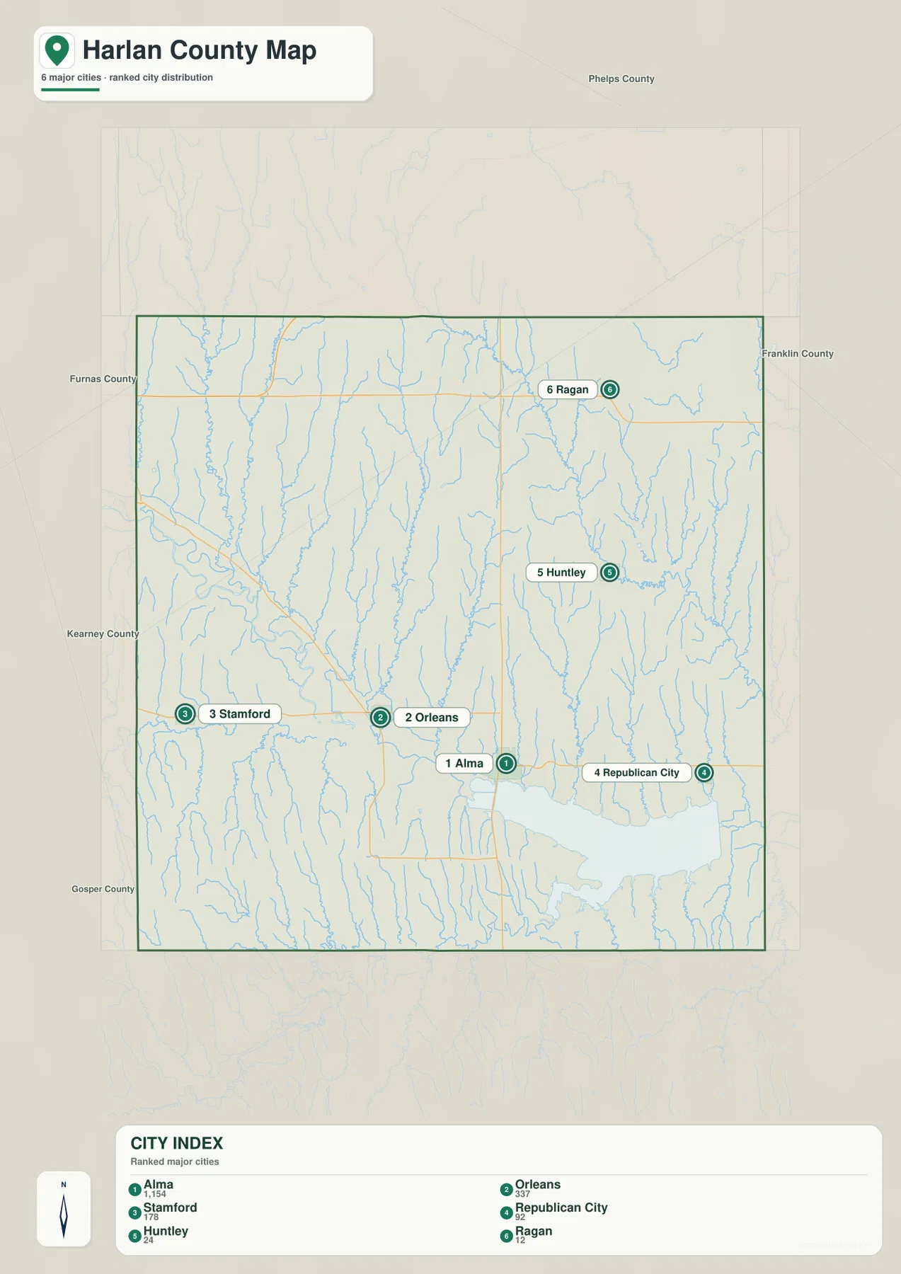
For trip planning, the city sheet is most useful as a first look rather than as a navigation product. It shows which places are near one another and which are separated by large rural areas, but it does not provide turn-by-turn routes, current closures, bridge conditions, or travel times. After identifying the community you need, a current road service should be used for actual driving directions.
The Republican River and reservoir organize the county’s water geography
The terrain and water sheet makes the Republican River the main geographic thread. The river enters from the west, follows the low southern corridor past the Orleans area, and continues toward Alma before reaching the broad water body of Harlan County Lake. Prairie Dog Bay is labeled on the eastern side of the reservoir, making the lake’s irregular shoreline easier to recognize than it is on the more general county map.
A number of named tributaries add detail to that larger system. Spring Creek, Rope Creek, Foster Creek, School Creek, and the Cambridge Canal appear in the western half; Millers Creek and Flag Creek occupy more central positions; and Turkey Creek is a prominent named drainage in the east. Many additional unnamed channels descend southward between them. Together they show that the northern upland is dissected by repeated valleys rather than being a single uninterrupted plain.
Harlan County Lake is a reservoir on the Republican River, not a natural lake. The U.S. Army Corps of Engineers manages the lake and surrounding project lands and describes purposes that include flood control, irrigation, recreation, fish and wildlife management, and sediment storage. That official context helps explain why the reservoir dominates the southeastern part of the county map and why Alma and Republican City are so closely associated with the water corridor.
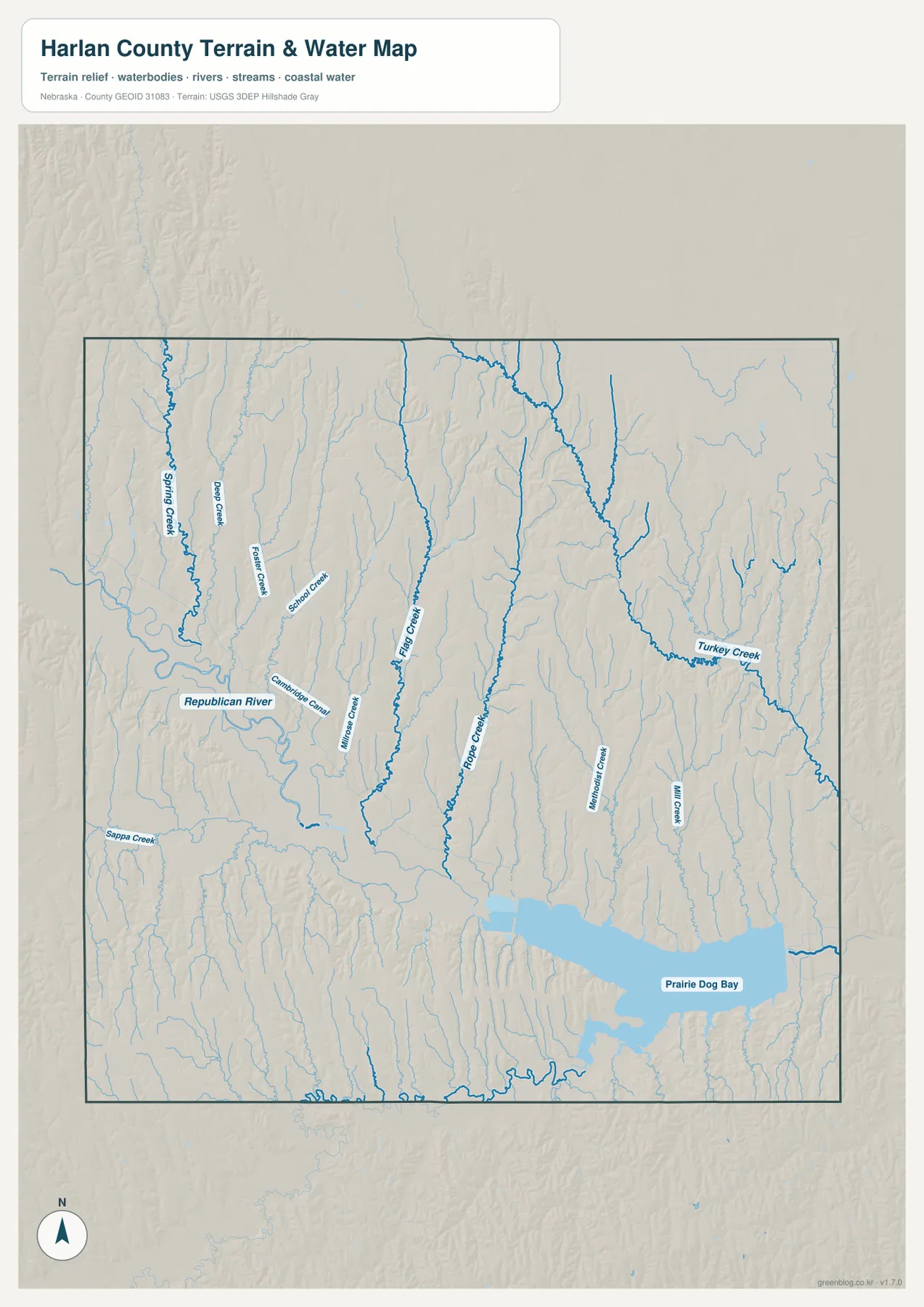
This is a reference map of water features and terrain, not a flood-zone, parcel, boating-navigation, or legal shoreline map. It is useful for understanding how streams connect and where the reservoir sits within the county, but questions about current lake levels, ramps, recreation rules, or operational conditions should be checked through the Corps of Engineers or another current official source.
Elevation drops into the river corridor and rises across the northern uplands
The elevation sheet adds the clearest view of the county’s relief. Its legend shows an actual mapped range of about 569 to 725 meters, with a mean near 651 meters. The lowest green band follows the Republican River valley from the west toward Alma and expands around Harlan County Lake. Higher tan and brown terrain occupies much of the north, northwest, and northeast, where small valleys cut into the upland surface.
Comparing the elevation and water sheets explains why the creek network looks so dense. Many tributaries begin or pass through higher ground and descend toward the broad southern valley. Their valleys create narrow fingers of lower terrain extending northward from the Republican River system. The result is a county with a large-scale southward drop in elevation but plenty of local variation created by individual creek channels.
Settlement geography also becomes clearer in this view. Alma, Orleans, Stamford, and Republican City are associated with the lower southern corridor, while Huntley and Ragan occupy the higher interior. That does not mean elevation alone determined settlement, but the maps show a close visual relationship between communities, transportation routes, the major river valley, and the reservoir. The sheet is generalized, however, and should not be used as survey-grade or engineering-grade elevation data.
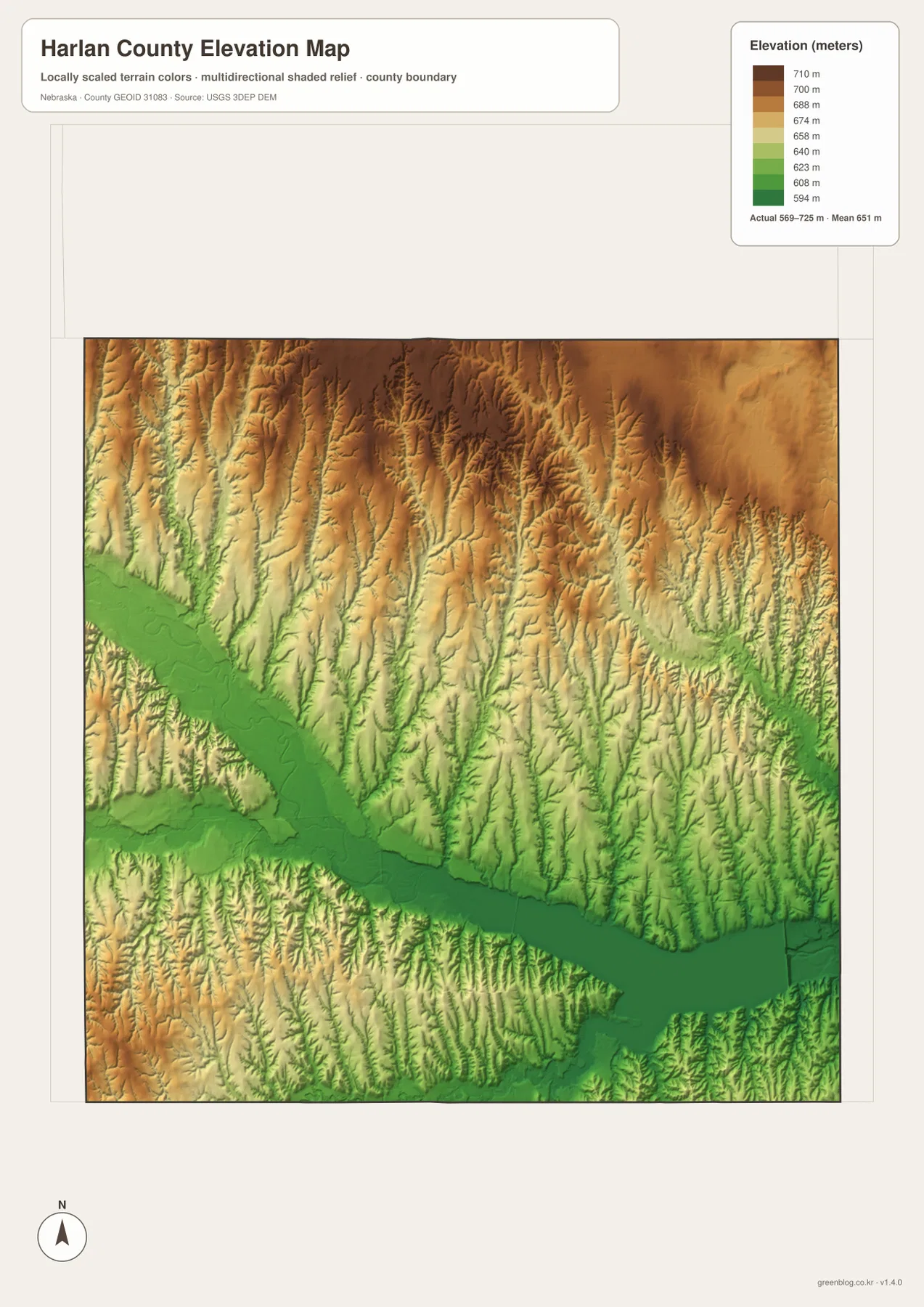
When using a printed copy, read the color scale together with the shaded relief. A brown area is not automatically a steep slope; the shading shows where creek valleys, ridges, and side slopes break up the higher surface. Placing the elevation map beside the water map makes it easier to match named streams with the lower valleys they occupy.
Roads, water, and relief explain the county better when read together
A single boundary map can make Harlan County look fairly uniform, but the four-sheet set shows a more varied internal geography. The southern half contains most of the prominently mapped communities, the Republican River corridor, and the reservoir. The northern half has fewer settlement labels and a stronger pattern of branching valleys cut into higher land. The difference is visible without relying on technical GIS analysis because the same features repeat across the county, water, and elevation sheets.
The road pattern reinforces that contrast. East-west routes connect the southern communities, while north-south roads link Alma and other southern locations with the interior. Near the northwestern side, roads continue toward the Oxford and Atlanta area, helping place the county in relation to Furnas County and neighboring communities. The general map is intentionally simplified, so numbered road labels should be used for orientation rather than as a substitute for a current highway or maintenance map.
For classroom work or regional comparison, a useful sequence is to start with the general map for names and boundaries, move to the city sheet for settlement distribution, then compare the water and elevation sheets. That sequence can answer practical geographic questions: why Alma appears next to the reservoir, why the Orleans area is tied to the Republican River corridor, and why Ragan sits amid a higher, more dissected landscape.
Choose the sheet that matches the question you are asking
Use the general county map when the task is to locate communities, compare roads, or understand the county boundary in relation to nearby places. It is the most balanced sheet and works well as a printed reference because no single theme overwhelms the others. The city sheet is better when the main question is how Alma, Orleans, Stamford, Republican City, Huntley, and Ragan are distributed across the county.
Choose the terrain and water sheet when stream names and drainage relationships matter. It makes the Republican River, Harlan County Lake, Prairie Dog Bay, and named tributaries much easier to follow. Choose the elevation sheet when the question concerns relative height, valley floors, uplands, or the broad contrast between the lower south and the higher north. Because the four maps emphasize different information, using the correct sheet usually makes the county easier to explain than trying to extract every answer from one image.
For a printed project, you can use one map by itself or keep the full set together for comparison. The high-resolution originals preserve more detail than the on-page preview and are better for close reading of labels and relief. They are still reference graphics rather than cadastral, survey, or engineering documents, so specialized legal or technical work should rely on the appropriate official datasets.
Frequently Asked Questions
Where is Alma in relation to Harlan County Lake?
Alma appears immediately northwest of Harlan County Lake on the supplied maps. The Republican River approaches from the west and continues into the reservoir system near Alma, so the general, water, and elevation sheets all show the community beside the county’s main low-lying water corridor.
Why does Oxford appear on the county map but not in the six-place city index?
Oxford lies along the western county edge and is associated with both Furnas and Harlan counties. The general map includes it as an important reference near the boundary, while the city sheet uses a simplified six-place ranking that omits Oxford. For a complete administrative list, the official Harlan County and Nebraska government sources are more appropriate than the simplified city index.
Can the elevation map be used for surveying or construction design?
No. The elevation sheet is designed to show county-scale relief and the contrast between the low Republican River and reservoir corridor and the higher uplands. Its 569–725 meter range is useful for geographic comparison, but parcel-level elevations, grading, engineering, and construction decisions require current survey data and authoritative technical sources.
Map File Information
The ZIP package contains the same four maps discussed on this page as original high-resolution JPG files suitable for printing and close inspection.
- Included Files: County map, city location map, terrain and water map, elevation map
- File Type: JPG files in a ZIP archive
Related Maps
Sources and references
These official sources are useful for checking county administration, the reservoir, boundaries, hydrography, and elevation data. The maps on this page are simplified for readable reference, so specialized or current questions should be verified against the relevant source below.
- Harlan County, Nebraska official website – county offices and community information
- U.S. Army Corps of Engineers – Harlan County Lake – official reservoir management and recreation information
- U.S. Census Bureau TIGER/Line – county boundary and geographic reference data
- USGS National Hydrography – river and stream reference data
- USGS 3D Elevation Program – elevation data
Green Map creates custom-edited map images using open geographic data sources such as geoBoundaries, Natural Earth, OpenStreetMap, and government open data. These maps are edited visual materials, not raw data files, and are provided for education, documents, presentations, and graphic reference.