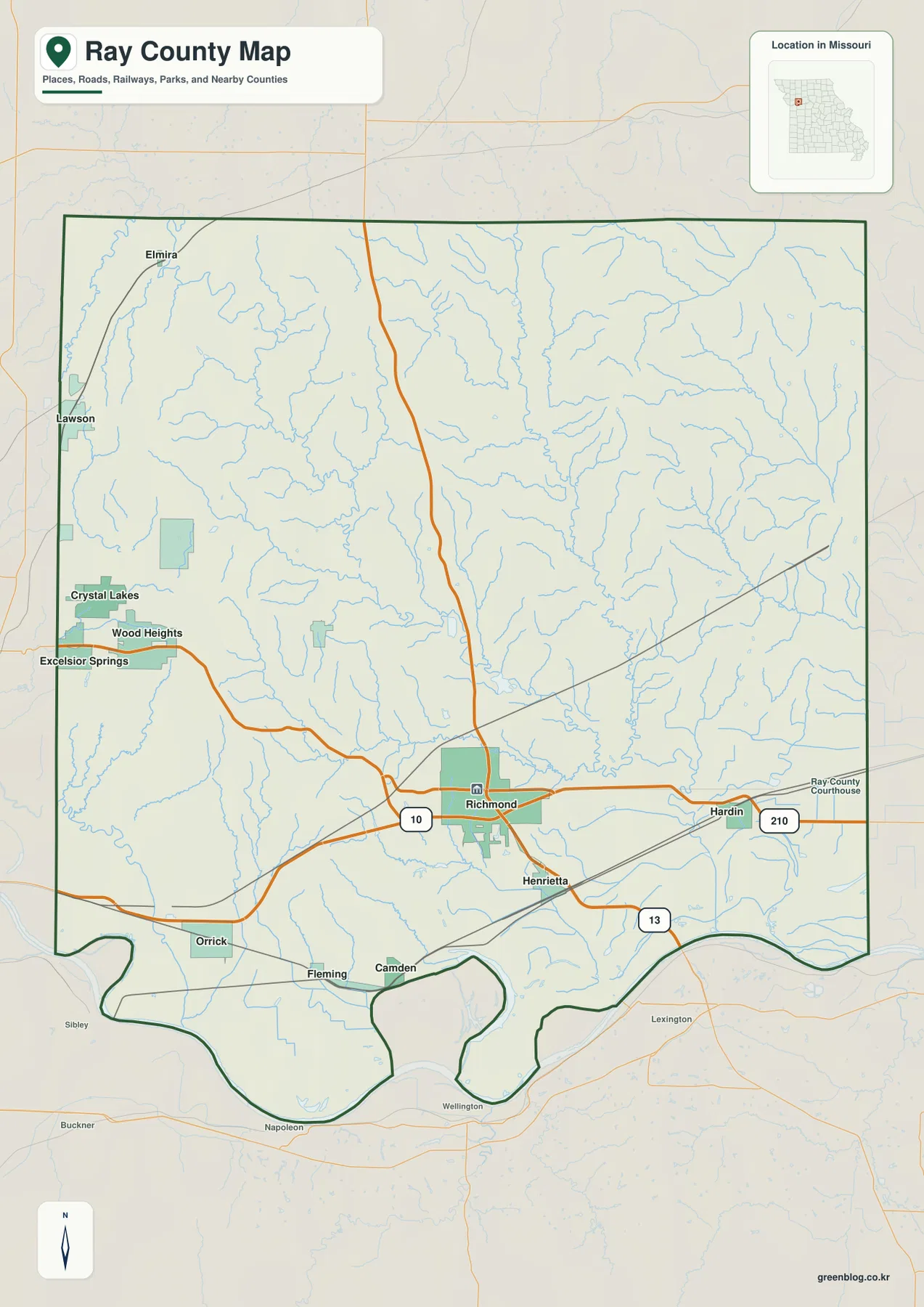
Ray County lies east of the Kansas City area in western Missouri, with Richmond providing the clearest road and settlement reference. Hardin sits to the east, Henrietta to the southeast, Orrick to the southwest, and Wood Heights and Crystal Lakes to the west. Route 10 gives the county a strong east-west road reference, while Route 13 runs north-south through the Richmond area. The landscape changes dramatically from high rolling uplands in the northwest to the broad Missouri River lowlands along the southern edge. High-resolution map files are available for download in the section below.
This page separates those features into a general county map, a city distribution map, a terrain-and-water map, and an elevation map. High-resolution JPG originals of all four can be downloaded together in one ZIP for closer viewing, A3 printing, classroom work, reports, or other large-format reference use.
Table of Contents
Richmond provides the clearest reference for Routes 10 and 13
Richmond sits in the south-central part of the county and is the easiest place to begin reading the general map. Its urban footprint is much larger than the surrounding communities, and the road network converges around it. Route 10 passes through the area from west to east, while Route 13 provides the main north-south reference.
Hardin lies east of Richmond along the same general east-west corridor. Henrietta is southeast of Richmond and closer to the broad lowlands near the Missouri River. The relationship between these three places gives the eastern half of the county an easy orientation before the smaller rural roads are considered.
Wood Heights and Crystal Lakes are clustered on the western side, while Orrick sits farther southwest. The western communities lie among higher rolling terrain, but Orrick is much closer to the southern lowland. This contrast becomes especially clear when the road map is compared with the elevation view.
Elmira appears in the northwest, while Lawson is shown just outside the western county boundary. Neighboring places help clarify where the county line sits relative to the local road network. A practical sequence is Richmond first, Hardin to the east, Orrick to the southwest, and Wood Heights and Crystal Lakes to the west.
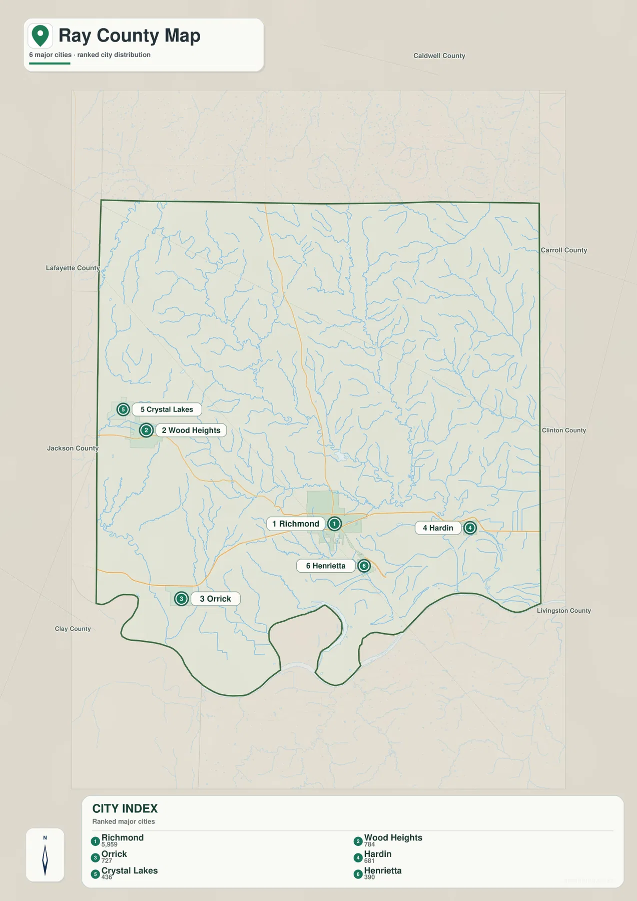
Richmond stands apart from five smaller highlighted communities
The city map highlights Richmond, Wood Heights, Orrick, Hardin, Crystal Lakes, and Henrietta. Richmond ranks first and is shown with 5,959. Wood Heights is second with 784, Orrick third with 727, Hardin fourth with 681, Crystal Lakes fifth with 436, and Henrietta sixth with 390.
The differences in the index make Richmond’s role as the principal urban center obvious, but the smaller places also provide important geographic anchors. Wood Heights and Crystal Lakes identify the west, Orrick the southwest, Hardin the east, and Henrietta the southeast. Together they outline the most settled portion of the county.
Henrietta is useful when comparing the urban corridor with the Missouri River lowlands because it sits between Richmond and the southern edge. Orrick occupies a similar transition farther west. Wood Heights and Crystal Lakes, by contrast, sit within higher western uplands that look very different on the elevation map.
The city map intentionally removes most minor roads and stream labels so the settlement pattern is easy to see. The general map includes smaller places and nearby communities outside the county, so the two views serve different purposes. Starting with the six highlighted places makes the later water and elevation maps easier to interpret.
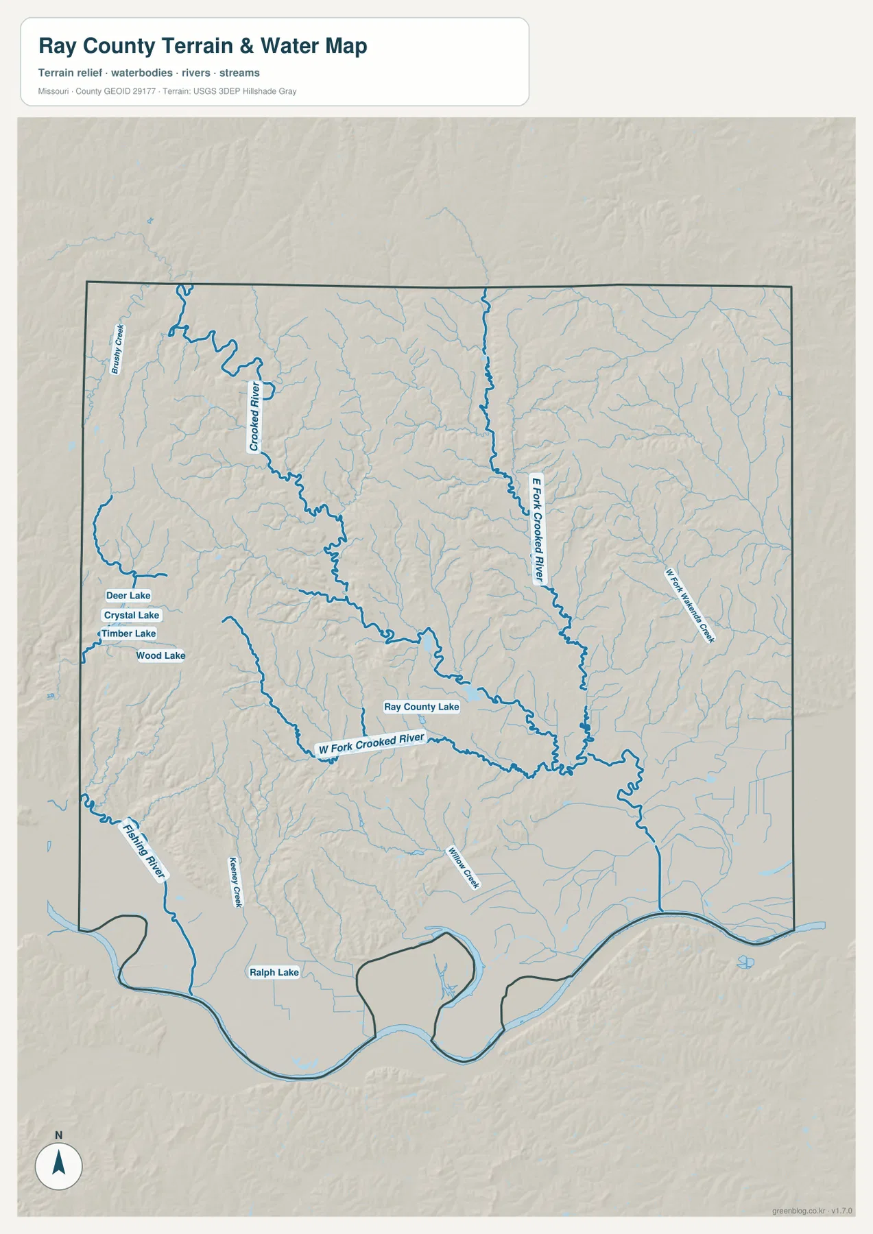
Crooked River and its east and west forks divide the interior hills
Crooked River is the dominant water feature through the interior of Ray County. It descends from the northwest and receives both the East Fork Crooked River and the West Fork Crooked River. Their combined valleys create a broad branching network of lower terrain through the center of the county.
The East Fork Crooked River forms a long north-south corridor in the eastern-central county, while West Wakenda Creek lies farther east. Blacksnake Creek appears near the northwestern edge. In the west, Deer Lake, Crystal Lake, Timber Lake, and Wood Lake form a small cluster of named waterbodies.
Fishing River cuts through the southwest toward the Missouri River lowlands. Keeney Creek and Wilson Creek add smaller southern valleys, while Ray County Lake provides an easy central landmark. Ralph Lake appears close to the southern edge and helps identify the broad lowland zone on the terrain map.
The terrain-and-water map is intended for geographic reference, not flood determination, depth analysis, navigation, parcel boundaries, or legal water boundaries. River stages and local stream conditions can change, so current flood or safety decisions should rely on the appropriate official source.
Elevation ranges from about 205 to 333 meters
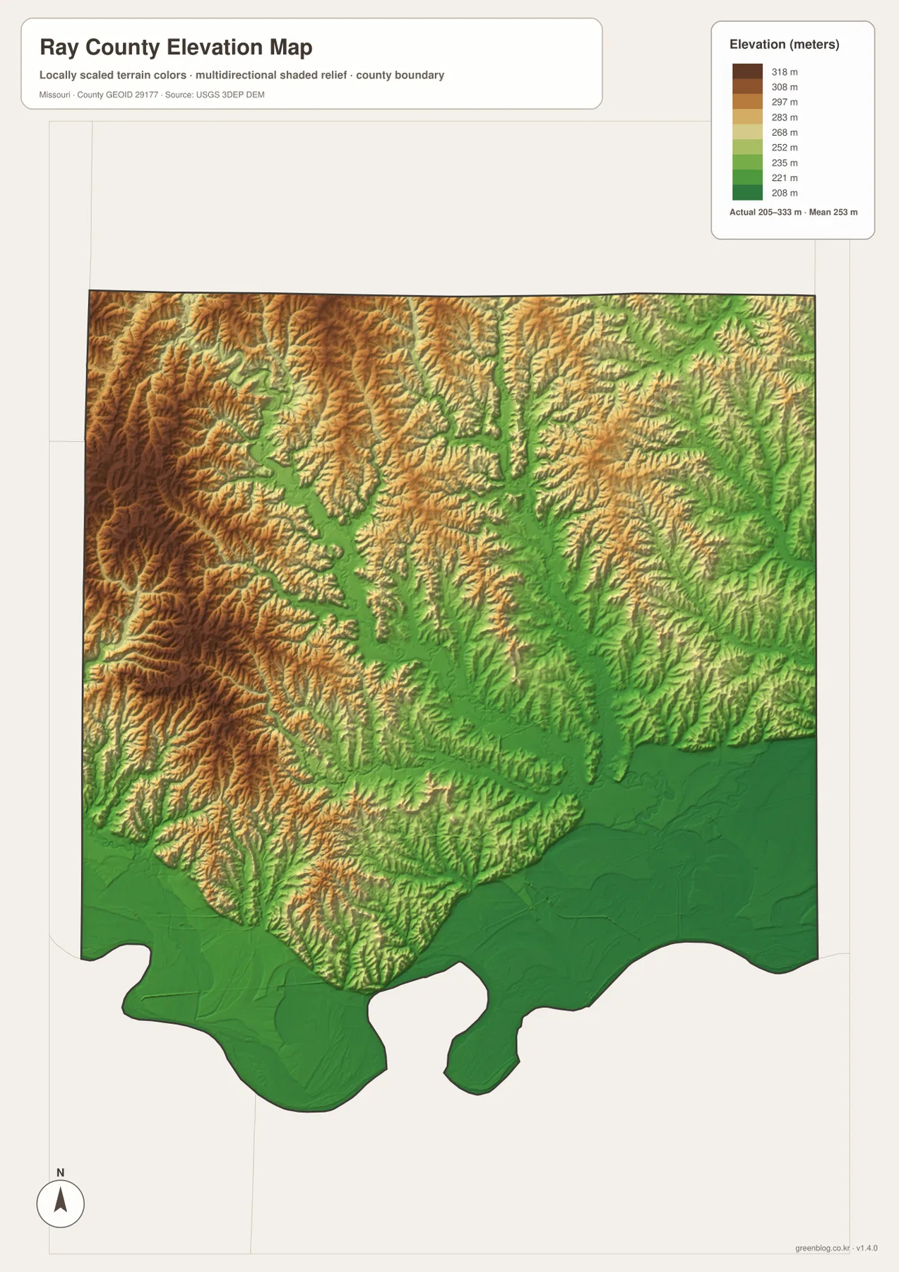
The elevation map reports an actual range of roughly 205 to 333 meters and a mean near 253 meters. The highest brown terrain is concentrated in the northwest and west, where tightly spaced ridges rise above numerous creek valleys. This is the strongest highland area in the county.
Across the center, the Crooked River and its east and west forks create long green low corridors between the uplands. The terrain does not simply descend in one direction; instead, lower valleys branch through higher ridges wherever the river system cuts across the county.
The southern edge changes much more dramatically. Broad dark-green Missouri River lowlands occupy a large area south of Orrick, Richmond, and Henrietta, creating the county’s lowest and flattest terrain. Away from the river, elevations rise quickly into the dissected interior hills.
This county-scale elevation surface is useful for broad relief comparison, not for engineering, construction, drainage design, parcel-level elevation decisions, or survey-grade measurement. Site-specific work requires more detailed official elevation data or field surveying.
Use Richmond, the Crooked River system, and elevation colors as reference layers
Start with the general county map when roads and settlement locations matter most. Richmond and Routes 10 and 13 provide an immediate framework, after which Hardin, Henrietta, Orrick, Wood Heights, and Crystal Lakes are easy to place. The city map is faster when you only need the relative location and scale of the six highlighted communities.
For waterways, begin with Crooked River and then trace the East Fork and West Fork. Fishing River, Blacksnake Creek, and Ray County Lake provide useful references for the southwest, northwest, and center. Moving to the elevation map afterward shows how those waterways occupy lower corridors between much higher ridges.
Ray County is especially useful for comparing three distinct settings within one county: high northwestern uplands, a branching Crooked River valley system through the interior, and broad Missouri River lowlands in the south. The road map shows where communities connect, while the water and elevation maps explain the physical terrain between them.
The downloadable JPG originals contain more pixels than the WebP previews embedded on the page, making them better for enlargement, A3 printing, classroom handouts, reports, and personal reference. They remain general-purpose maps, however. Legal boundaries, property ownership, live road restrictions, flood status, and precise site elevations should always be checked against the appropriate current official source.
Frequently Asked Questions
Which roads are the easiest references in Ray County?
Routes 10 and 13 around Richmond are the clearest starting points. Route 10 provides the main east-west reference, while Route 13 helps organize north-south travel through the central county.
How much elevation change is shown across Ray County?
The elevation map shows an actual range of about 205 to 333 meters with a mean near 253 meters. Northwestern ridges are highest, while the Crooked River valleys and southern Missouri River lowlands occupy much lower ground.
Which waterways are the best starting points on the terrain map?
Start with Crooked River and its East Fork and West Fork. Fishing River in the southwest, Blacksnake Creek in the northwest, and Ray County Lake near the center provide additional useful landmarks.
Map File Information
The download ZIP contains high-resolution JPG versions of the Ray County general map, city map, terrain-and-water map, and elevation map.
- File Type: JPG
Related Maps
Sources and References
Boundary and road reference data are supported by U.S. Census Bureau TIGER/Line, water features by USGS National Hydrography, and elevation data by the USGS 3D Elevation Program.
Green Map creates custom-edited map images using open geographic data sources such as geoBoundaries, Natural Earth, OpenStreetMap, and government open data. These maps are edited visual materials, not raw data files, and are provided for education, documents, presentations, and graphic reference.