Randolph County lies in north-central Missouri, with Moberly providing the clearest road and urban reference. Huntsville sits to the west, Higbee and Renick to the south, Cairo to the north, and Clark near the southeastern edge. U.S. 63 runs north-south through the Moberly and Cairo corridor, while U.S. 24 crosses the western-central county through Huntsville. A dense network of Chariton tributaries cuts lower valleys across the west and center, while higher ridges become more extensive toward the east. High-resolution map files are available for download in the section below.
This page separates those features into a general county map, a city distribution map, a terrain-and-water map, and an elevation map. High-resolution JPG originals of all four can be downloaded together in one ZIP for closer viewing, A3 printing, classroom work, reports, or other large-format reference use.
Table of Contents
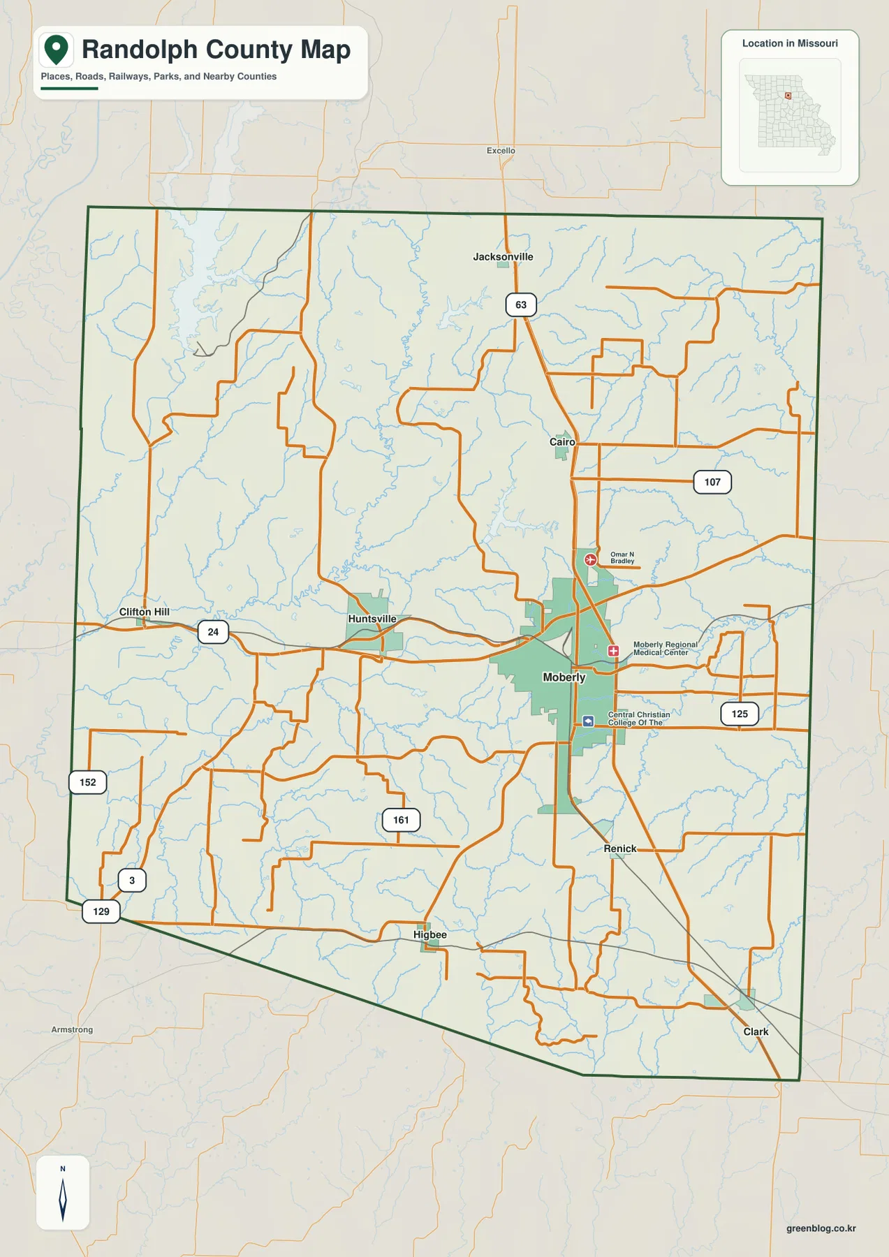
Moberly anchors U.S. 63 while U.S. 24 links the western county
Moberly sits slightly east of the county’s center and is the easiest place to begin reading the general map. U.S. 63 passes the city and continues north through Cairo toward Jacksonville, giving the county a strong north-south reference. The larger urban footprint around Moberly also makes the city easy to distinguish from the surrounding rural road network.
U.S. 24 enters from the Clifton Hill side in the west and passes through Huntsville before continuing toward the Moberly area. That corridor gives Huntsville a clear relationship to the county’s largest city. Once U.S. 24 and U.S. 63 are located, the northern and central portions of the map become much easier to organize.
Route 107 stands out in the east, while Route 125 serves the Moberly and southeastern side. Route 161 crosses the south-central interior near Higbee and Renick. Routes 3 and 129 appear in the southwest, and Route 152 provides another western reference. These roads help fill in the large rural spaces between the main highways.
Many local roads bend around creek valleys rather than following a perfectly straight grid. That is especially noticeable across the west and center, where tributaries are closely spaced. Using Moberly and the U.S. 63 corridor first, then adding Huntsville and U.S. 24, provides a practical framework before moving to the smaller roads.
Moberly dominates a six-community settlement pattern
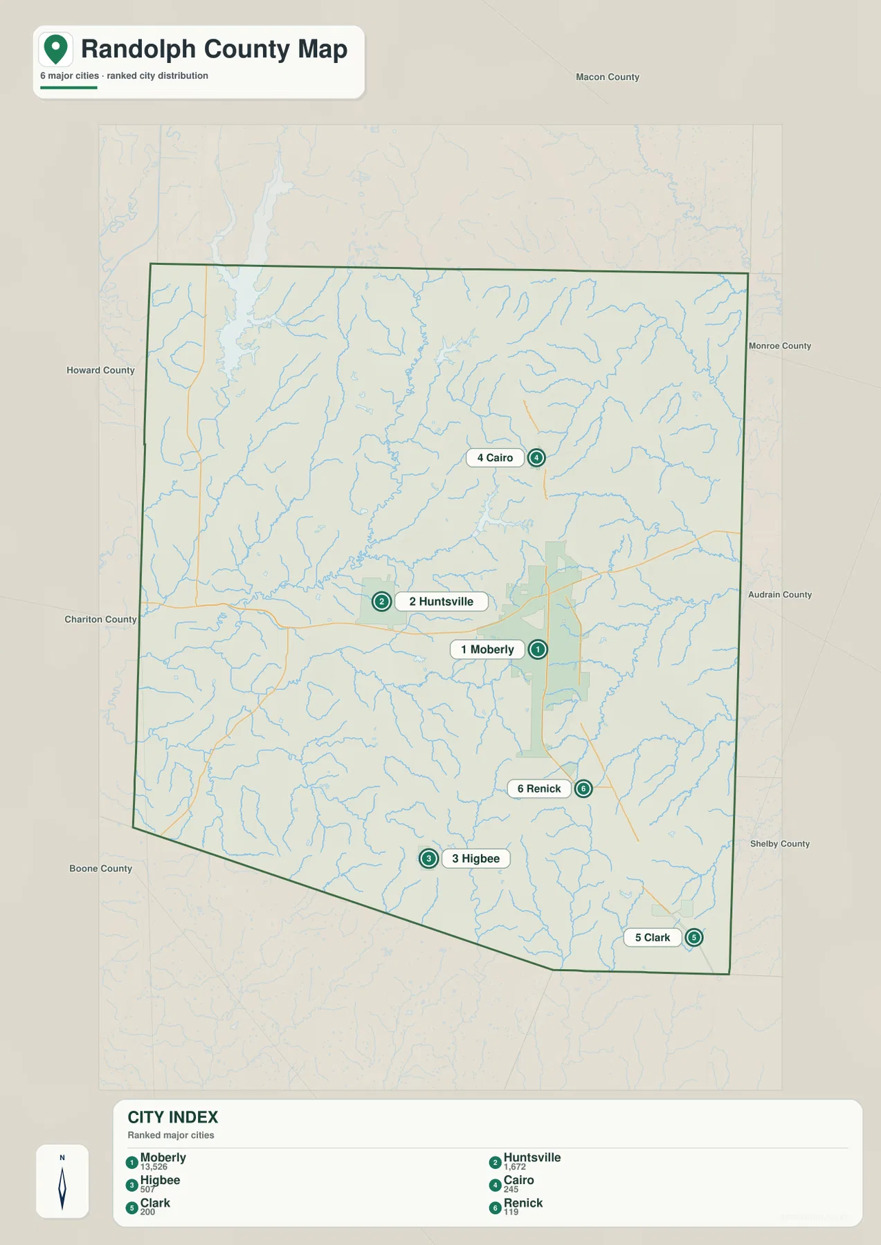
The city map highlights Moberly, Huntsville, Higbee, Cairo, Clark, and Renick. Moberly is labeled with 13,526, far above Huntsville at 1,672. Higbee is shown with 507, Cairo with 245, Clark with 200, and Renick with 119, making the contrast between the main city and the smaller communities immediately visible.
Huntsville lies west of Moberly, Higbee to the south, Cairo to the north, and Renick just southeast of the main urban corridor. Clark sits farther toward the southeastern corner. The six places therefore spread in several directions, but the strongest concentration remains around the Moberly side of the county.
The ranking is useful as a quick guide to relative size, but each place also serves a geographic role. Huntsville helps identify the U.S. 24 corridor, Cairo anchors the northern U.S. 63 segment, and Higbee provides a reference for the south-central countryside. Renick and Clark are useful when reading the higher southeastern terrain.
The simplified city view removes most minor roads and stream labels. Jacksonville and Clifton Hill appear on the general map but are not part of the six-community city index. Using both maps prevents the city ranking from being mistaken for a complete settlement inventory.
Chariton tributaries carve long valleys through the county
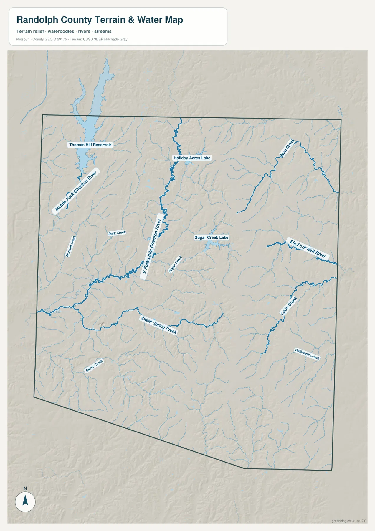
The Middle Fork Chariton River is the strongest water reference in the northwestern and western county. It continues south from the Thomas Hill Reservoir area and receives many short tributaries. The dense branching pattern explains why the western terrain is divided into so many narrow ridges and valleys.
The East Fork Little Chariton River forms another long corridor through the central county. Holiday Acres Lake lies near its northern section, while Sugar Creek Lake appears farther east in the interior. Dark Creek and Sugar Creek add smaller low corridors around the central drainage system.
Mud Creek is prominent in the northeast, and the Elk Fork Salt River crosses the eastern side. Sweet Spring Creek runs through the southern interior, with Coon Creek and Galbreath Creek forming separate southeastern valleys. Silver Creek provides another useful reference in the southwest.
The terrain-and-water map is intended for geographic reference, not flood determination, depth analysis, navigation, parcel boundaries, or legal water boundaries. Reservoir levels and stream conditions can change, so current flood, boating, or safety decisions should rely on the appropriate official source.
Elevation ranges from about 151 to 279 meters
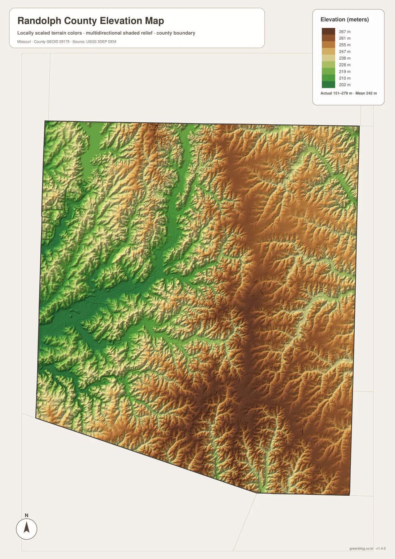
The elevation map reports an actual range of roughly 151 to 279 meters and a mean near 242 meters. The lowest dark greens follow the Middle Fork Chariton River in the west and the East Fork Little Chariton River through the center. These long low corridors stand out clearly against the surrounding ridges.
Higher tan and brown terrain becomes more extensive across the eastern half and southeast. Uplands east of Moberly and toward Clark rise well above the major Chariton valleys, while Mud Creek and the Elk Fork Salt River cut lower passages between them. The northeastern county also shows a strong ridge-and-creek pattern.
The west is generally lower, but it is not flat. Tributaries divide the landscape into many small ridges, and the low terrain around the Middle Fork broadens toward the Thomas Hill Reservoir side. Moving east across the county, the elevation colors become progressively warmer and higher ridges occupy more of the map.
This county-scale elevation surface is useful for broad relief comparison, not for engineering, construction, drainage design, parcel-level elevation decisions, or survey-grade measurement. Site-specific work requires more detailed official elevation data or field surveying.
Use Moberly, the Chariton valleys, and elevation colors as reference layers
Start with the general county map when roads and settlement locations matter most. Moberly and U.S. 63 provide an immediate framework, after which Huntsville and U.S. 24, Cairo to the north, and Higbee and Renick to the south are easy to place. The city map is faster when you only need the relative distribution and scale of the six highlighted communities.
For waterways, begin with the Middle Fork Chariton River and the East Fork Little Chariton River, then compare Mud Creek and the Elk Fork Salt River. Thomas Hill Reservoir, Holiday Acres Lake, and Sugar Creek Lake provide additional landmarks. Moving to the elevation map afterward shows how these waterways occupy lower corridors between ridges.
Randolph County combines a sizable urban center around Moberly with a largely rural landscape cut by numerous streams. The road map explains how the communities connect, while the water and elevation maps reveal the broad contrast between lower western-central valleys and higher eastern uplands.
The downloadable JPG originals contain more pixels than the WebP previews embedded on the page, making them better for enlargement, A3 printing, classroom handouts, reports, and personal reference. They remain general-purpose maps, however. Legal boundaries, property ownership, live road restrictions, flood status, reservoir conditions, and precise site elevations should always be checked against the appropriate current official source.
Frequently Asked Questions
Which roads are the easiest references in Randolph County?
U.S. 63 and U.S. 24 are the clearest starting points. U.S. 63 links the Moberly, Cairo, and Jacksonville corridor north-south, while U.S. 24 connects Huntsville with the central part of the county.
How much elevation change is shown across Randolph County?
The elevation map shows an actual range of about 151 to 279 meters with a mean near 242 meters. Major Chariton tributary valleys are lower, while the east and southeast contain broader higher uplands.
Which waterways are the best starting points on the terrain map?
Start with the Middle Fork Chariton River in the west and the East Fork Little Chariton River through the center. Mud Creek, the Elk Fork Salt River, and Sugar Creek Lake provide useful eastern and central references.
Map File Information
The download ZIP contains high-resolution JPG versions of the Randolph County general map, city map, terrain-and-water map, and elevation map.
- File Type: JPG
Related Maps
Sources and References
Boundary and road reference data are supported by U.S. Census Bureau TIGER/Line, water features by USGS National Hydrography, and elevation data by the USGS 3D Elevation Program. County offices and government information are available from the official Randolph County website.
Green Map creates custom-edited map images using open geographic data sources such as geoBoundaries, Natural Earth, OpenStreetMap, and government open data. These maps are edited visual materials, not raw data files, and are provided for education, documents, presentations, and graphic reference.