Boone County is easiest to learn by starting in Albion. The county seat sits near the middle of the map, with Petersburg to the north, St. Edward to the southeast, Cedar Rapids to the southwest, and Primrose farther west. Between those communities, Beaver Creek, the Cedar River, and many smaller valleys break up a landscape of rolling agricultural uplands. High-resolution JPG versions of the maps are available in a ZIP on this page for printing or closer study. High-resolution map files are available for download in the section below.
The four maps tell different parts of the same story. The general map shows how roads spread out from Albion, the city map compares nearby communities, the water map follows the county’s main creek and river valleys, and the elevation map explains why the western side feels higher than the east. Reading them together makes Boone County look less like a simple rectangle of farmland and more like a network of small towns connected by roads and low stream corridors.
Table of Contents
Start in Albion to understand how the county’s towns spread out
Albion is the county seat and the most useful anchor for the rest of Boone County. Official county pages place the courthouse and county offices there, and the map shows several important roads meeting in or near the community. Petersburg lies to the north, St. Edward to the southeast, Cedar Rapids to the southwest, and Primrose toward the west. The towns do not form one continuous built-up corridor, so direction matters as much as distance.
Neighboring counties provide another orientation layer. Antelope County is north, Madison and Platte Counties are east, Nance County is south, and Greeley and Wheeler Counties lie to the west. Boone County is longer north-to-south than east-to-west, with a few steps in the southern and southwestern boundary. Those boundary changes are modest, but they help distinguish the Cedar Rapids and Primrose side from neighboring rural areas.
Roads from Albion lead in different directions even when towns look equally close
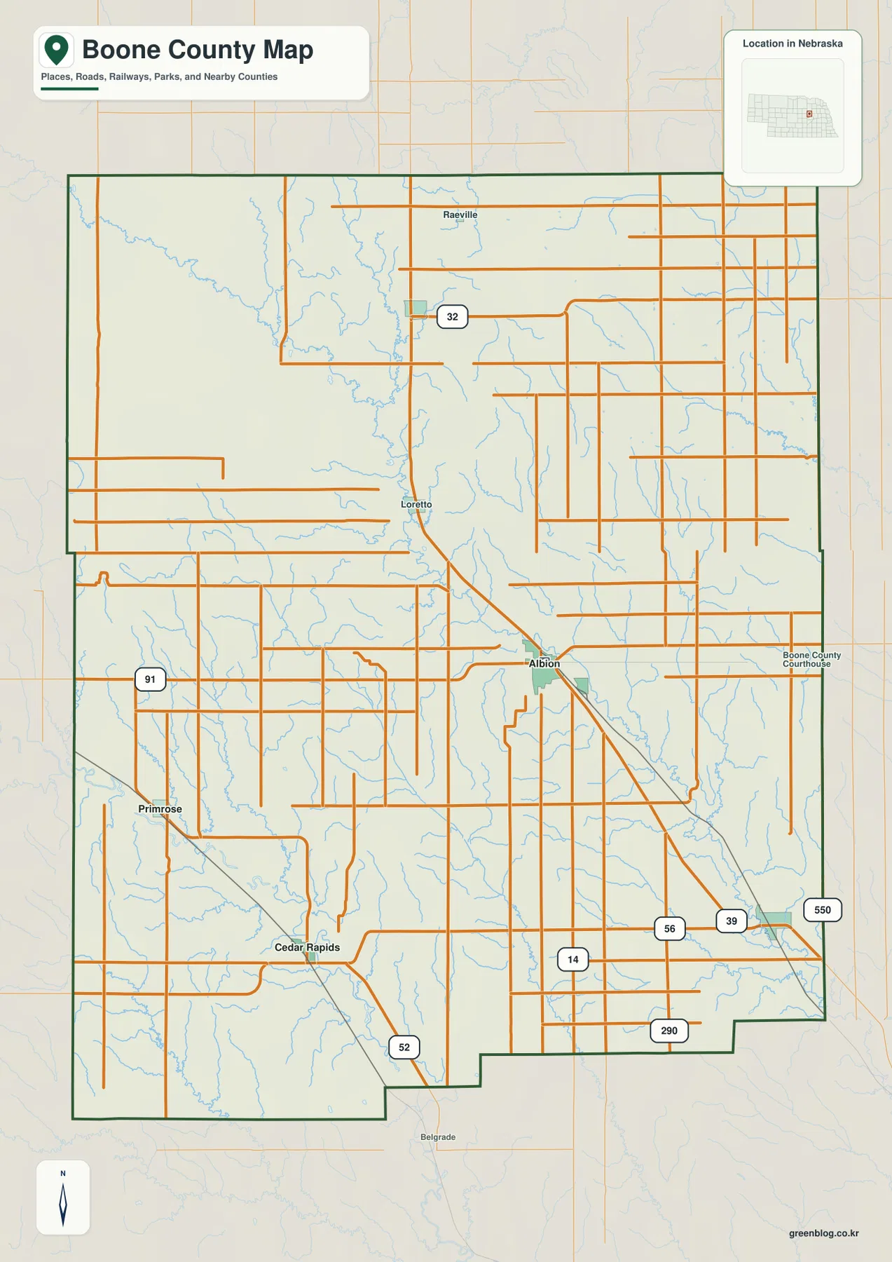
Nebraska Highway 14 provides the simplest north-south reference through the Albion area. Roads continue north toward Petersburg and other rural communities, while routes to St. Edward, Cedar Rapids, and Primrose turn toward different parts of the county. Routes marked 91 and 52 are visible in the west and southwest, Highway 32 crosses the north, and roads marked 39 and 56 appear toward the southeast.
St. Edward and Cedar Rapids may appear similarly close to Albion, but they are reached in nearly opposite directions. St. Edward sits southeast of the county seat, while Cedar Rapids is southwest. Primrose is farther west, and Petersburg is almost directly north. The road map therefore works best when used for direction first and distance second.
The Boone County Courthouse is labeled near Albion, and Raeville provides another northern reference near Petersburg. Belgrade appears outside the county to the southwest, helping show where roads continue beyond the boundary. The map is not a live road-status product, so current construction, closures, and travel times should be checked separately before driving.
Four towns sit within a narrow straight-line distance band around Albion
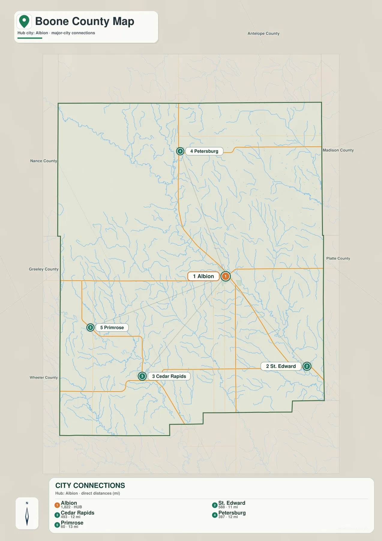
The city map uses Albion as the hub. It shows about 11 straight-line miles from Albion to St. Edward, roughly 12 miles to Cedar Rapids, 12 miles to Petersburg, and 13 miles to Primrose. These are direct point-to-point measurements, not driving distances. Road mileage is longer because each trip follows a different route.
The small spread between 11 and 13 miles is less important than the directions. Petersburg is north, St. Edward southeast, Cedar Rapids southwest, and Primrose west. In other words, Boone County’s leading small communities form a loose ring around Albion rather than a line of towns along one highway.
The markers also rank the selected places, with Albion shown as the largest. That ranking is useful for comparing the map’s chosen communities, but it is separate from county-government status. Albion’s role as county seat comes from official county records, not simply from the size of its marker.
Beaver Creek gives the middle of Boone County a recognizable low corridor
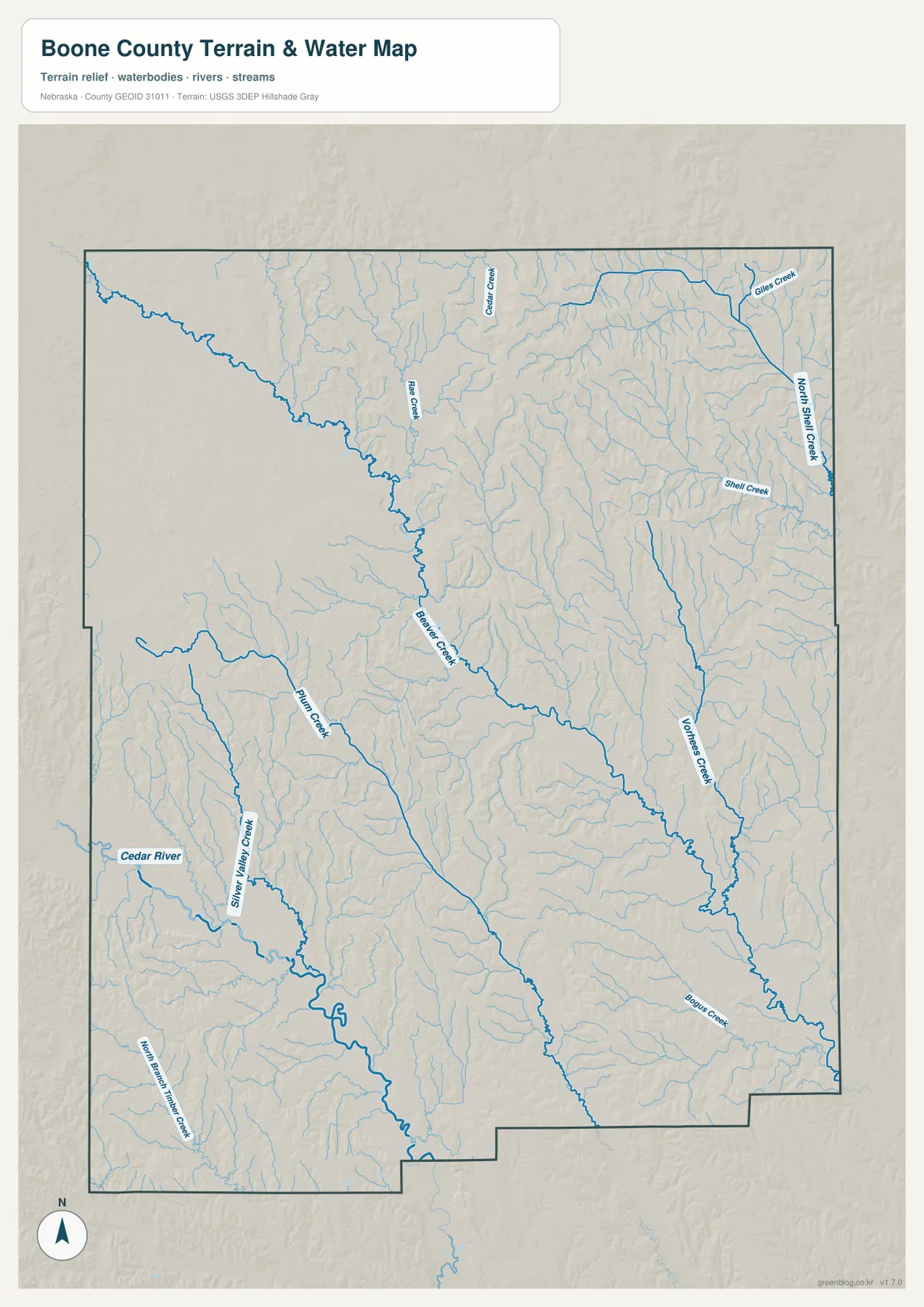
Beaver Creek is one of the easiest waterways to follow. It enters from the northwest, angles through the middle of the county, and continues toward the southeast while collecting numerous small tributaries. On the terrain view, the creek does more than add a blue line: it marks a long lower corridor through the rolling uplands.
The Cedar River defines a different part of the county in the southwest, where Silver Creek and Plum Creek join nearby valleys. Shell Creek and North Shell Creek stand out in the northeast, and Vorhes Creek runs through the eastern-central part of the map. These waterways make different parts of Boone County easy to recognize without relying only on road numbers.
Ash Creek and Cedar Creek appear farther north, while many shorter unnamed tributaries fill the spaces between the larger channels. Rather than one dominant river crossing the entire county, Boone County has several low creek and river corridors that divide the uplands into smaller local landscapes.
The water map is for geographic reference. It does not define current streamflow, flood zones, legal water rights, parcel boundaries, or public access. Those questions require current information from USGS or the appropriate Nebraska and local agencies.
Higher western ground gradually gives way to lower eastern valleys
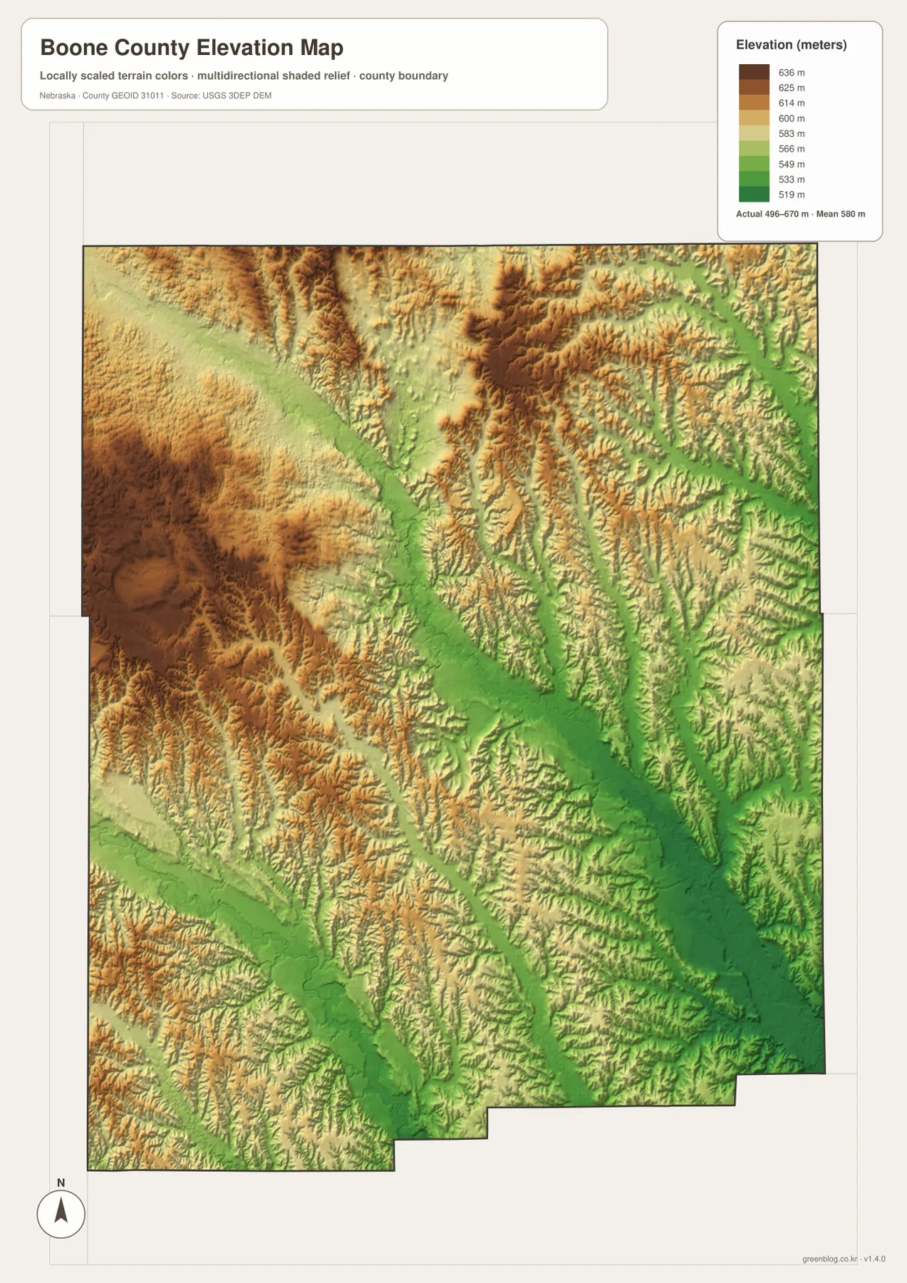
The elevation map shows a county-wide range of about 496 to 670 meters, with a mean near 580 meters. Browns and tans are more common across the west and southwest, while greens spread across the east and southeast. The county is not mountainous, but the roughly 170-meter difference is enough to create a clear west-to-east change.
Beaver Creek appears as a lower green band through the middle, and the Cedar River and Silver Creek occupy another low corridor in the southwest. Shell Creek and Vorhes Creek also trace greener terrain on the east side. When the elevation map is compared with the water map, the main channels line up naturally with the county’s lower ground.
The western uplands are rolling rather than mountainous. Rounded rises are broken by narrow valleys, especially in the northwest and west-central portions. Toward the southeast, lower ground opens more broadly around the stream network, giving St. Edward’s side of the county a different visual character from the higher western half.
The color scale is local to Boone County and is intended for relative comparison within this map. A matching color on another county map may represent a different absolute height. The surface is generalized and should not be treated as survey-grade elevation for construction, engineering, drainage design, or property work.
Albion’s central role comes from both geography and county government
Viewed together, the maps show why Albion works so well as the county’s reference point. Several roads meet there, four mapped communities sit within about 11 to 13 straight-line miles, and Beaver Creek passes through the broader central area. Albion therefore links travel, settlement, and the county’s water-and-terrain pattern in one location.
The other communities each have a different local setting. Cedar Rapids and Primrose sit closer to the Cedar River and the higher western side, St. Edward is toward the lower eastern terrain, and Petersburg opens toward the northern agricultural countryside. Those differences are subtle on the city map but become obvious when the water and elevation maps are added.
County-seat history and rail connections helped strengthen Albion’s position
Boone County’s official history and History Nebraska record the county’s organization in 1871. Early residents debated the location of the permanent county seat, and Albion was selected in 1872. Its near-central position on the modern map helps give geographic context to that choice, even though nineteenth-century political decisions involved more than distance alone.
The first train reached Albion in 1880, followed by additional rail connections later in the decade. Railroads are not the focus of today’s map, but they helped concentrate trade and travel around the county seat. Modern roads now carry most of the visible transportation story, yet Albion remains the same central administrative reference that emerged during that earlier period.
A simple way to read all four Boone County maps together
Begin with Albion on the county map and use Highway 14 to establish north and south. Then move to the city map and note how Petersburg, St. Edward, Cedar Rapids, and Primrose surround the county seat in different directions. That establishes the human geography without requiring a long list of road names.
Next, follow Beaver Creek through the middle of the water map, then find the Cedar River in the southwest and Shell Creek and Vorhes Creek toward the east. The elevation view finishes the picture by showing those waterways in lower terrain and the western uplands at higher elevations. The sequence turns four separate graphics into one coherent view of the county.
For printing or classroom use, the high-resolution JPG files in the download archive preserve more label detail than the web previews. Use the general map for roads and boundaries, the city map for Albion-centered straight-line comparisons, the water map for named streams, and the elevation map for the west-to-east change in relief.
Frequently Asked Questions
Are the 11-13 mile values from Albion driving distances?
No. The city map shows straight-line distances: about 11 miles to St. Edward, 12 miles to Cedar Rapids, 12 miles to Petersburg, and 13 miles to Primrose. Driving mileage is longer because each trip follows the available road network.
Which waterway is the easiest central reference near Albion?
Beaver Creek is the clearest central water reference. The Cedar River is more useful in the southwest near Cedar Rapids and Primrose, while Shell Creek and Vorhes Creek help orient the eastern side of the county.
Can the 496-670 meter elevation range be used for surveying?
No. The range summarizes a generalized county-wide surface intended for geographic comparison. Surveying, construction, engineering, and detailed drainage work require original elevation data and, where appropriate, professional field measurements.
Map File Information
The ZIP contains the original high-resolution JPG files for the Boone County boundary and road map, city-connection map, terrain and water map, and elevation map.
- Included Files: Use only the versions confirmed in the article and supplied images
- File Type: Use the confirmed download contents
- Intended Use: Printing, education, presentations, and map-based projects
Related Maps
Sources and references
- Boone County official profile
- Boone County – A Historical Sketch of Boone County
- History Nebraska – Boone County Historical Note
- U.S. Census Bureau TIGER/Line Shapefiles
- USGS National Hydrography
- USGS 3D Elevation Program
These maps are intended for geographic reference. For legal boundaries, land ownership, flood determinations, water rights, road conditions, construction, surveying, or other decisions requiring current authoritative information, consult Boone County and the responsible state or federal agency.
Green Map creates custom-edited map images using open geographic data sources such as geoBoundaries, Natural Earth, OpenStreetMap, and government open data. These maps are edited visual materials, not raw data files, and are provided for education, documents, presentations, and graphic reference.