Plymouth County stretches across southeastern Massachusetts from the inland Brockton area to a long Atlantic shoreline facing Plymouth Bay, Cape Cod Bay, and Buzzards Bay. Its shape brings together two very different geographic settings: a western side with major roads and closely spaced communities, and a broad eastern and southern side where bays, tidal shorelines, streams, ponds, and less densely labeled interior land dominate the map. Starting with Brockton and then tracing east toward Route 3 and Plymouth Bay is an effective way to understand how large and varied the county is.
This page provides a general county map with roads and place names, a simplified ranked-city map focused on Brockton and Bridgewater Town, and a terrain-and-water reference highlighting rivers and coastal water. The same three map themes are available as original high-resolution JPG files in a downloadable ZIP. They are designed for regional orientation, printing, classroom use, and presentations rather than live traffic, parcel research, flood-hazard decisions, or marine navigation.
Table of Contents
From Brockton and Route 24 to Route 3 and the long South Shore coastline
The general map makes the county’s long north-south and east-west reach easy to see. Brockton sits on the western side close to the Norfolk County boundary, with Route 24 running south through that part of the map. Farther northeast, Hull occupies a narrow coastal position, while North Scituate and Scituate continue down the shoreline. Marshfield Hills and Marshfield appear below them. These places show that Plymouth County is not simply the area around the town of Plymouth; it also includes a substantial portion of the South Shore north of Plymouth Bay.
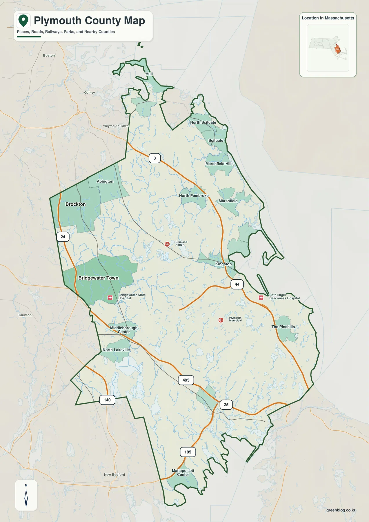
Route 3 is the clearest highway reference for the northeastern and eastern side. It descends from the Boston direction, passes inland from the Scituate-Marshfield coast, and continues toward the Kingston area. Because the shoreline bends while Route 3 follows a more direct inland course, the road helps separate coastal communities from the county’s interior. A reader trying to place Scituate, Marshfield, North Pembroke, and Kingston can use Route 3 as the central reference and then look east or west from it. The map is not a live routing product, so current closures and travel times still require a current transportation source.
The western side works differently. Route 24 runs near Brockton and continues south toward the Bridgewater side of the county. Abington lies north of Brockton, while Bridgewater Town is farther southeast. Bridgewater State Hospital and Middleborough Center provide additional landmarks farther down the map. The large central area between Route 24 and Route 3 is crossed by smaller roads and contains many streams and ponds. This spacing is important because it keeps the western and eastern road corridors from looking like one continuous urban strip.
Route 44 is useful for understanding the middle of the county. It crosses the interior toward the Kingston-Plymouth side and sits near the broad area marked by Plymouth Municipal Airport. Farther south, Route 495 and Route 25 create another set of references near the approach toward Cape Cod. Route 140 appears along the southwestern side, and I-195 is visible near the South Coast beyond or close to the county’s lower boundary. These roads occupy different bands of the map, so each one is more useful for a particular section than for the county as a whole.
The coastline changes character several times. Around Hull and the northern South Shore, the county outline is narrow and irregular. The coast then runs past Scituate and Marshfield toward Plymouth Bay, where the eastern side opens into a much larger stretch of land and water. Farther south, the county approaches Cape Cod Bay and then bends toward Buzzards Bay through a more indented shore with small inlets and peninsulas. Following that outline from north to south helps explain why coastal distance inside Plymouth County cannot be reduced to one simple shoreline segment.
Several labels help with orientation in the broad interior. Kingston is shown east of the center, North Lakeville appears in the southwest, and The Pinehills is marked in the southeastern half. Mattapoisett Center is labeled near the lower edge as surrounding regional context. Some labels sit close to or beyond the green county boundary, so a place name appearing on the map should not automatically be treated as being inside Plymouth County. The boundary line is the correct reference when distinguishing county territory from nearby communities in Bristol, Norfolk, or other neighboring areas.
The map also includes facilities such as Cranland Airport, Plymouth Municipal Airport, Bridgewater State Hospital, and Beth Israel Deaconess Hospital. They are useful orientation points, not a complete inventory of airports or hospitals. Plymouth Municipal Airport, for example, quickly identifies the eastern-central area west of Plymouth Bay, while the Brockton-Route 24 combination anchors the western side. Using a few recognizable roads and facilities in this way can make the county easier to explain than relying on the boundary outline alone.
For a first pass, start at Brockton, follow Route 24 south toward the Bridgewater area, then move east to Route 3 and Kingston before continuing toward Plymouth Bay. Route 44 links part of the interior, while Routes 495 and 25 help organize the southern section. This sequence reveals the county’s scale without requiring every small place name to be read at once. The general map is therefore the best choice when roads, communities, the boundary, and coastal context all need to appear together.
Brockton and Bridgewater Town place the ranked-city emphasis on the western interior
The city-distribution map removes most of the detailed road and place labels and highlights only two ranked locations. Brockton is marked as number 1 on the western side, and Bridgewater Town is number 2 farther southeast. The most useful observation is geographic rather than numerical: both ranked points are inland and lie in the western half of a county with an extensive Atlantic coast. That contrast helps prevent the common assumption that the county’s main settlement pattern must follow Plymouth Bay simply because the county carries the Plymouth name.
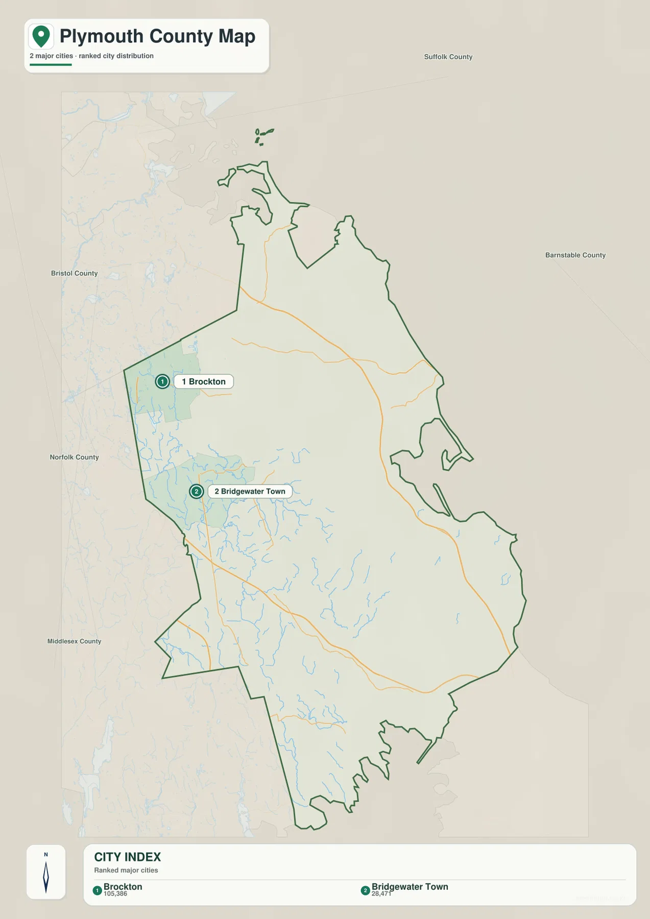
The CITY INDEX prints 105,386 for Brockton and 28,477 for Bridgewater Town. Those figures should be treated as values from the dataset used to create this particular graphic, not as guaranteed current population estimates. Population totals change when new estimates or census products are released. If a current population figure is important, the latest U.S. Census Bureau data should be checked separately. On this map, the values primarily explain why Brockton receives the first rank and Bridgewater Town the second.
Brockton’s marker sits near the county’s western edge, consistent with the general map where the city is close to Route 24 and the Norfolk County side. Bridgewater Town appears southeast of Brockton, within the broader inland area that leads toward Middleborough and the Taunton River network. With nearly all other labels removed, the directional relationship is immediate. This makes the city map useful for a slide or worksheet that needs to compare only those two selected locations without the visual density of highways, hospitals, airports, and coastal place names.
The simplified map should not be interpreted as a complete list of important Plymouth County communities. Plymouth, Scituate, Marshfield, Kingston, Pembroke, and many other towns do not appear as ranked markers even though they are important to the county’s geography. The graphic has a narrow purpose: comparing the two locations selected for its CITY INDEX. When the topic shifts to South Shore communities or the Plymouth Bay coast, the general map is a more appropriate reference.
The large blank-looking eastern and southern areas are also worth noting. They are not empty territory. The detailed map and the terrain-and-water map show many towns, ponds, streams, wooded interior areas, and a long coastline across those sections. Removing that detail is what allows the Brockton-Bridgewater relationship to stand out. In practical use, the city map works best as a companion graphic: it answers a focused location question, while the other maps restore the road, water, and coastal context that has been intentionally omitted.
North River, Taunton River, inland ponds, and three very different coastal waters
The terrain-and-water map shifts attention away from highways and toward rivers, streams, ponds, bays, and coastal water. North River is labeled in the northeastern part of the county. Taunton River and Winnetuxet River define much of the western and central interior, while Nemasket River runs through the southwestern-southern area. Mattapoisett River appears near the South Coast. To the east, the much larger labels for the Atlantic Ocean, Plymouth Bay, Cape Cod Bay, and Buzzards Bay show how the county connects inland drainage to several distinct coastal settings.
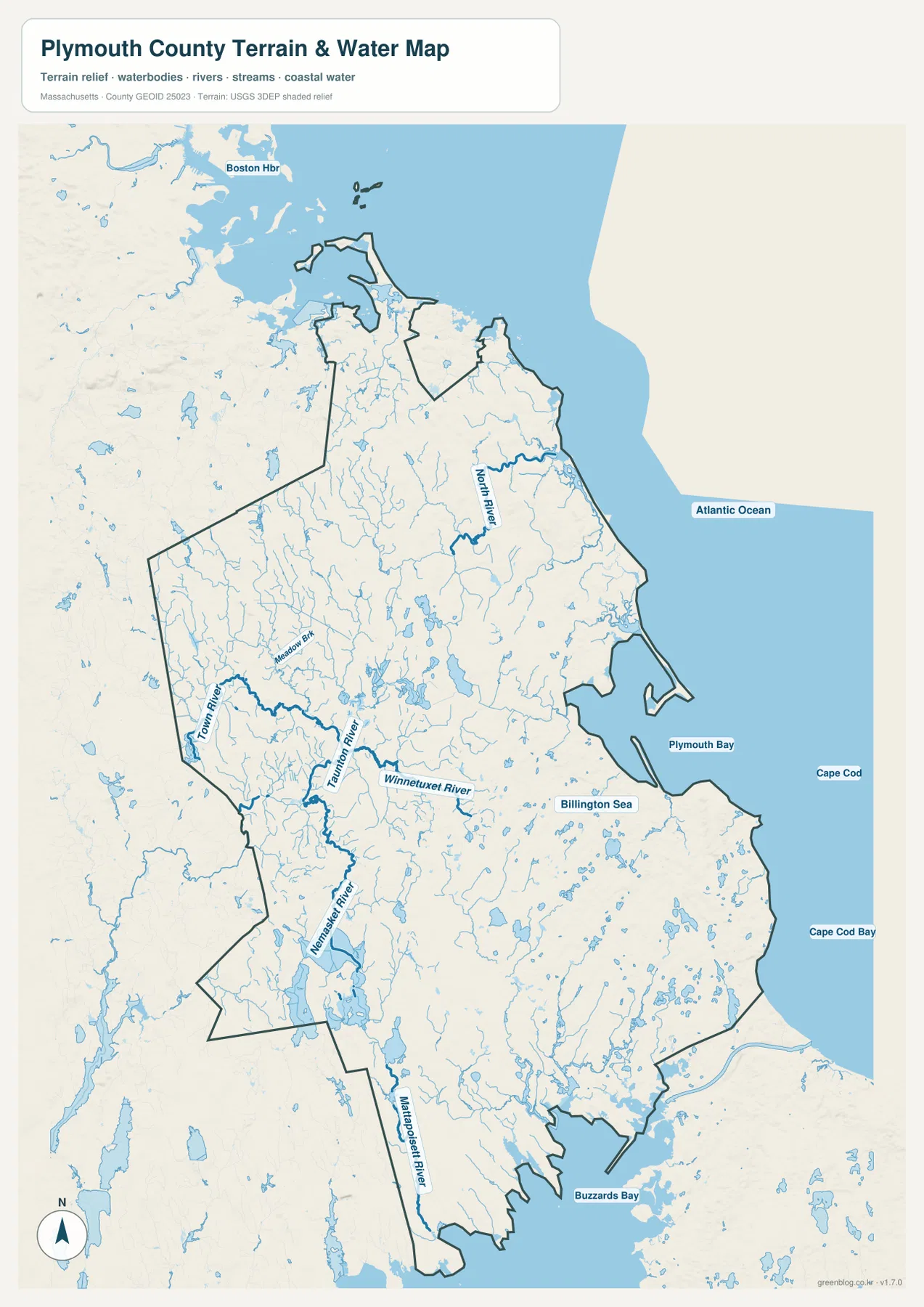
North River is the strongest named river reference near the northeastern coast. It bends through the South Shore interior before reaching the coastal side, with numerous small tributaries and ponds shown around it. Comparing this layer with the general map is useful because Route 3 follows a straighter inland course through roughly the same broad region. The river and highway therefore organize the landscape in different ways: one follows natural drainage, while the other provides a transportation reference through the inland side of Scituate-Marshfield-Pembroke country.
The Taunton River system is more important on the western side. Meadow Brook is labeled near the upper part of that network, and Winnetuxet River appears farther east before joining the broader drainage pattern. Nemasket River extends through the Lakeville-Middleborough side, surrounded by many smaller ponds and channels. On the road map, this interior can appear relatively open between the larger city labels. The water map shows that the same area is actually broken into many small drainage features and water bodies.
Plymouth Bay provides the clearest coastal reference on the eastern side. Billington Sea is labeled inland nearby, and many small streams and ponds occupy the surrounding land. North of the bay, the open water is labeled Atlantic Ocean; farther south, Cape Cod Bay becomes the larger regional context. These water labels are useful for orientation, but they extend beyond the county boundary. The map is showing the geographic setting around Plymouth County rather than claiming that every labeled offshore area is administratively part of the county.
Buzzards Bay gives the southern coast a noticeably different appearance from Plymouth Bay and the northern South Shore. The lower boundary is more deeply indented, with small peninsulas and coves, and Mattapoisett River reaches the coastal side in this region. I-195 and Mattapoisett Center on the general map help connect this water geography to the broader South Coast. Reading the county as a sequence of North River coast, Plymouth Bay-Cape Cod Bay coast, and Buzzards Bay coast is more informative than treating all of the shoreline as one uniform edge.
Small inland water bodies are especially numerous across the central and southeastern parts of the map. This pattern fits the official description of Myles Standish State Forest in the Plymouth-Carver area, where Massachusetts identifies many kettle ponds formed in glacial depressions. The map itself does not classify every pond by origin, and it should not be used to infer water quality or ecological condition. Still, the combination of the official park information and the dense pond symbols helps explain why southeastern Plymouth County appears so water-rich even away from the ocean.
The background relief is best treated as a broad terrain reference rather than an exact elevation product. Plymouth County does not appear as a high mountain landscape; instead, subtle relief, stream valleys, and low coastal areas create the main visual differences. The map contains no survey-grade spot elevations or detailed contour lines. A precise height or slope for a road, house, trail, or construction site should be checked with a dedicated elevation dataset such as the USGS 3D Elevation Program rather than estimated from this shaded background.
The blue river and bay symbols also do not represent flood depth, current flow, navigable channels, legal shoreline limits, or water quality. A thick river line is a cartographic symbol, not a measurement of actual width. This is particularly important around Plymouth Bay and Buzzards Bay, where a regional water-reference map and a marine navigation chart answer very different questions. Use this map to understand where named waterways and coastal waters sit in relation to the county, then use the appropriate official source for a specialized decision.
Choosing between the road overview, the two-city comparison, and the water reference
The general county map is the strongest starting point when you need an overall orientation. Brockton and Route 24 anchor the west, Route 3 organizes much of the northeastern and eastern side, and Route 44 provides an interior east-west reference. Routes 495, 25, 140, and I-195 help with the southern section. Because the same view includes coastal communities, airports, hospitals, and the county boundary, it works well for a regional introduction or printed handout.
The ranked-city map is better for a deliberately narrow comparison. It removes most other information so that Brockton and Bridgewater Town stand out as two western inland points. The terrain-and-water map answers a different set of questions by showing North River, Taunton River, Nemasket River, Plymouth Bay, Cape Cod Bay, and Buzzards Bay. Selecting the map that matches the question is more accurate than asking one image to serve as a road map, settlement map, hydrography map, and technical hazard product at the same time.
For printing, the original high-resolution JPGs in the downloadable ZIP will generally reproduce more cleanly than the web-sized images embedded in this article. The archive contains the general county map, the Brockton-Bridgewater city distribution map, and the terrain-and-water reference. Current road closures, legal boundaries, flood hazards, marine conditions, exact elevation, and updated population figures should always be checked through the relevant current authoritative source rather than inferred from these regional reference graphics.
Frequently Asked Questions
Why does the ranked city map show only Brockton and Bridgewater Town?
It is a selective city-distribution graphic rather than a complete map of every Plymouth County municipality. Brockton and Bridgewater Town are the two locations chosen for the CITY INDEX, so places such as Plymouth, Scituate, Marshfield, Kingston, and Pembroke are not ranked on that version. Use the general county map when you need a broader set of community labels and road references.
Can the map showing Plymouth Bay and the Taunton River be used to determine flood risk?
No. The terrain-and-water graphic is a regional reference that shows the locations of rivers, ponds, bays, and coastal water. It does not map flood zones, flood depths, storm surge, water quality, channel depth, or navigational restrictions. Use FEMA, Massachusetts, or other current official hazard and marine products when those questions matter.
Which map is best for seeing Route 3 and Plymouth Bay in the same view?
The general county map is the best choice because it keeps Route 3, Route 44, nearby community labels, the county outline, and the eastern coastline together. If you then need more detail about North River, inland ponds, or the larger Plymouth Bay-Cape Cod Bay water setting, the terrain-and-water reference is the better companion map.
Map File Information
The ZIP contains the original high-resolution JPG versions of the general Plymouth County map, the Brockton-Bridgewater Town ranked city map, and the terrain-and-water reference described on this page.
- Included Files: general county map, ranked city-distribution map, terrain-and-water reference map
- File Type: JPG
Related Maps
Sources and References
The following official resources are useful for checking current Plymouth County statistics and government information, authoritative boundaries and hydrography, and the public-land context of southeastern Massachusetts.
- Plymouth County, Massachusetts – Official Website
- U.S. Census Bureau – Plymouth County QuickFacts
- Mass.gov – Myles Standish State Forest
- U.S. Census Bureau TIGER/Line Shapefiles
- USGS National Hydrography
Green Map creates custom-edited map images using open geographic data sources such as geoBoundaries, Natural Earth, OpenStreetMap, and government open data. These maps are edited visual materials, not raw data files, and are provided for education, documents, presentations, and graphic reference.