Adams County in south-central Nebraska is easiest to orient around Hastings, the county seat and largest place shown on the supplied city map. Kenesaw and Juniata lie to the west, while Roseland, Holstein, and Ayr are spread across the southern half. Major highways, Blue River tributaries, and a gradual drop in elevation from west to east give the county more geographic variety than its broad plains setting may suggest at first glance. High-resolution map files are available for download in the section below.
This page brings together a boundary-and-road map, a ranked city map, a water-and-terrain view, and an elevation map. The original high-resolution JPG versions can also be downloaded together in a ZIP, which is useful when a larger image is needed for printing, classroom material, or personal reference.
Table of Contents
Hastings provides the main reference point in Adams County
Adams County lies in south-central Nebraska, and Hastings serves as the county seat. The county’s official website states that Adams County was incorporated on February 16, 1867. On the supplied map, Hastings occupies the eastern-central part of the county, where several important roads converge and the largest continuous developed area appears.
The rest of the county is predominantly rural on this map. Juniata and Kenesaw form smaller settlement areas to the west, while Roseland, Holstein, and Ayr are separated by broad stretches of open country in the south. That distribution makes Hastings a practical anchor for finding roads, streams, and smaller communities without treating the entire county as part of one continuous urban area.
U.S. 6 and U.S. 281 make the Hastings area easy to locate
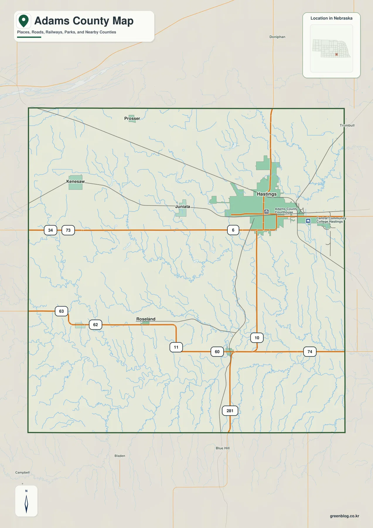
Begin with Hastings on the county map and follow U.S. 6 west toward Juniata. U.S. 281 runs south from the Hastings area toward the county line and on toward Blue Hill outside Adams County. Together, those two routes provide a simple east-west and north-south framework for reading the map before moving on to the smaller state and county roads.
Kenesaw lies northwest of Juniata, while the southern half is crossed by roads marked 62, 60, and 74. North-south routes marked 10, 11, and 63 connect those southern roads with the central part of the county. The road network is noticeably denser around Hastings, but the map still provides several clear routes for locating Roseland, Holstein, Ayr, and the rural areas between them.
Places outside the county, including Doniphan, Trumbull, and Blue Hill, are visible in the surrounding reference area. They are helpful for orientation, especially when viewing Adams County as part of the wider south-central Nebraska road network. The map is not a live navigation product, however, so construction, closures, road surface, and current travel times should be checked with an up-to-date routing or transportation service.
Six ranked communities show a clear Hastings-centered pattern
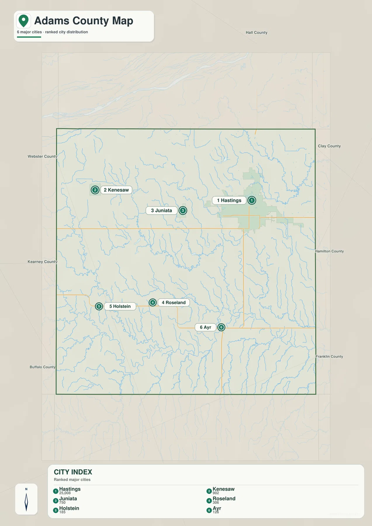
The city distribution map ranks six places: Hastings first, followed by Kenesaw, Juniata, Roseland, Holstein, and Ayr. Hastings is represented by the most prominent marker and developed area, while the other communities appear as much smaller points spread across the county. Kenesaw and Juniata form the western part of the northern group, and the remaining three communities occupy the southern half.
Unlike some county city maps, this one does not include connector lines or straight-line mileage between the ranked places. That absence matters because it would be misleading to add distance values that are not part of the supplied map. The useful comparison here is position: Hastings is east-central, Kenesaw is northwest, Juniata is west of Hastings, and Ayr is far to the south and east relative to the other small communities.
The joint City of Hastings and Adams County GIS system also distinguishes incorporated municipalities such as Hastings, Ayr, Holstein, and Kenesaw in its address data. The ranked map and the county GIS serve different purposes, but together they provide a reliable way to separate the main named communities from the many rural roads and scattered addresses across the county.
Big Blue and Little Blue tributaries divide the county into many shallow valleys
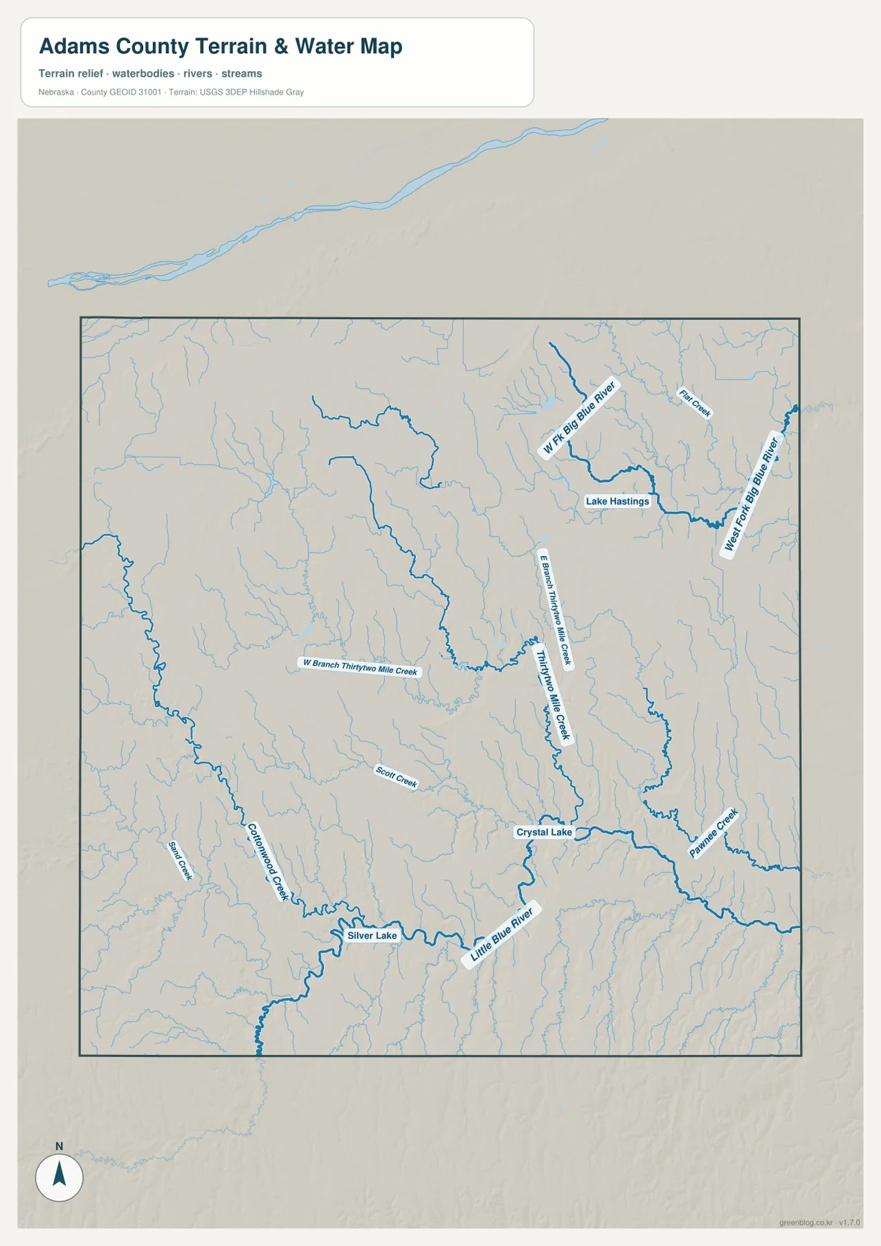
The water map shows two especially useful reference systems. West Fork Big Blue River occupies the northeastern side, with Lake Hastings and several smaller tributaries nearby. Farther south, the Little Blue River crosses the lower part of the county and receives water from a dense network of creeks that cut into the surrounding plains.
Through the center, Thirtytwo Mile Creek is joined by its east and west branches. Scott Creek and Pawnee Creek appear farther south and east, while Cottonwood Creek and Sand Creek provide additional reference lines in the southwest. Crystal Lake and Silver Lake are labeled near the southern drainage network. These names help turn what might otherwise look like a uniform plain into a set of recognizable valleys and local watersheds.
The water layer is intended for geographic reference rather than flood or property decisions. A stream line does not show whether water is flowing at a particular moment, and the map does not define legal water rights, parcel ownership, flood insurance zones, or navigable channels. Those questions require current records from the appropriate local, state, or federal agency.
The elevation map falls from higher western ground toward the east
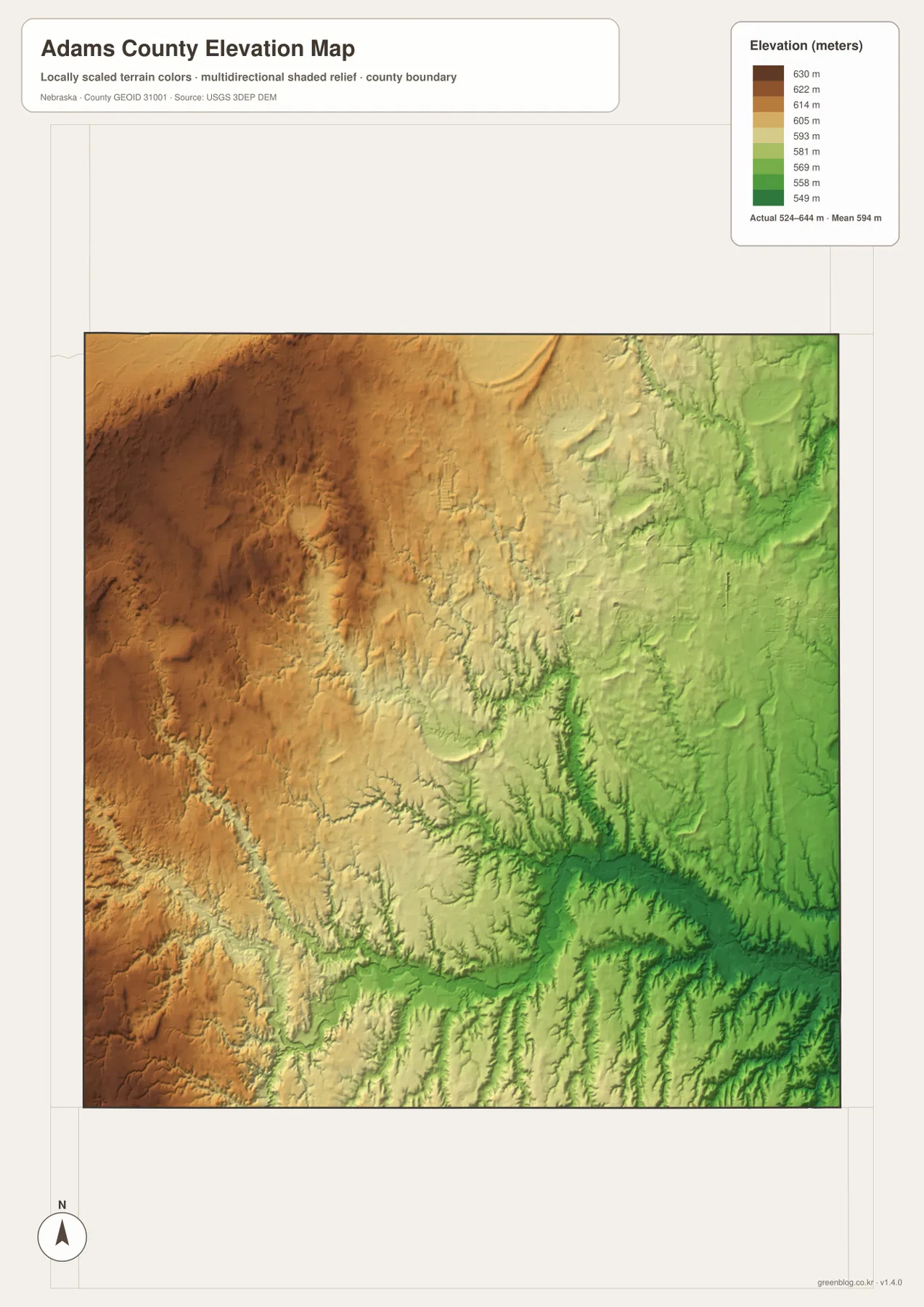
The elevation map reports an actual range of roughly 524 to 644 meters, with a mean near 594 meters. Brown and tan colors dominate the west and northwest, while green becomes more common toward the east. Adams County is not mountainous, but a difference of about 120 meters across the map is enough to reveal a broad west-to-east slope and a network of lower stream corridors.
The southern and southeastern parts contain especially clear branching valleys. The Little Blue River and its tributaries appear as lower corridors cut into slightly higher surrounding ground, and the Thirtytwo Mile Creek system creates another recognizable set of low lines through the middle. When compared with the water map, the elevation view explains why many blue stream lines follow the greener parts of the terrain.
Colors are scaled locally for Adams County, so they should be used to compare places within this map rather than matched directly with colors on another county map. The surface is also generalized for regional viewing. Engineering, construction, drainage design, and surveying require original elevation data and, where appropriate, professional field measurements.
Roads, streams, and lower ground come together around Hastings
Looking across the road, water, and elevation views explains why Hastings is such an effective map anchor. U.S. 6 and U.S. 281 meet the developed area, while West Fork Big Blue River tributaries and other small waterways occupy nearby lower ground. The city is not centered geometrically within the county, but its road connections make it the easiest place from which to orient the surrounding rural landscape.
West of Hastings, the terrain gradually rises toward Juniata and Kenesaw. South of the city, the map becomes more strongly dissected by the Little Blue River and smaller creeks around Roseland, Holstein, and Ayr. The county therefore changes in subtle but visible ways from one side to the other, even though the overall landscape remains part of Nebraska’s broad plains.
From Juniata to Hastings: a shift in the county seat
History Nebraska’s Adams County record notes that permanent settlement accelerated after 1869. Juniata was selected as the county seat in 1871, but the competing railroads ultimately joined at Hastings rather than Juniata. Hastings grew around that junction, and the county seat moved there in 1878. The present map makes the contrast easy to see: Hastings is now the dominant developed center, while Juniata remains a smaller community to the west.
The same historical record explains that Adams County was named for John Adams, the second president of the United States. That background is not necessary for using the map, but it gives context to the county’s early settlement and transportation history. It also helps explain why the relationship between Hastings and Juniata is more than a simple difference in present-day population rank.
Which Adams County map is most useful for your task?
For basic orientation, start with the county map and locate Hastings, U.S. 6, and U.S. 281. Then move west to Juniata and Kenesaw or south toward Roseland, Holstein, and Ayr. This view is the best choice when roads, community locations, and the outer county boundary need to be visible at the same time.
For physical geography, begin at Lake Hastings and West Fork Big Blue River, then follow the Thirtytwo Mile Creek system toward the center and the Little Blue River across the south. The elevation map adds another layer by showing how those waterways occupy lower ground between the higher western plains and the greener eastern side. The city map is the simplest choice when the main goal is comparing the relative position and rank of the six labeled communities.
Frequently Asked Questions
Does the city map show distances between Hastings and the other communities?
No. The supplied city map ranks and locates Hastings, Kenesaw, Juniata, Roseland, Holstein, and Ayr, but it does not draw city-to-city connector lines or provide straight-line mileage. Use a current routing service when actual road distance or travel time is needed.
Which waterways are easiest to identify on the Adams County map?
West Fork Big Blue River is prominent in the northeast and the Little Blue River crosses the southern part of the county. Thirtytwo Mile Creek and its branches run through the middle, while Lake Hastings, Crystal Lake, and Silver Lake provide additional reference points.
Can the 524-644 meter elevation range be used for surveying or engineering?
No. The values summarize a generalized county-wide elevation surface intended for geographic comparison. Surveying, construction, engineering, and detailed drainage work require original elevation data and, when appropriate, professional field measurements.
Map File Information
The ZIP contains the original high-resolution JPG files for the Adams County boundary and road map, ranked city map, terrain and water map, and elevation map.
- Included Files: Use only the versions confirmed in the article and supplied images
- File Type: Use the confirmed download contents
- Intended Use: Printing, education, presentations, and map-based projects
Related Maps
Sources and references
- Adams County, Nebraska official website
- City of Hastings & Adams County GIS Mapping
- History Nebraska – Adams County Records and Historical Note
- U.S. Census Bureau TIGER/Line Shapefiles
- USGS National Hydrography
- USGS 3D Elevation Program
These maps are intended for geographic reference. For legal boundaries, land ownership, flood determinations, water rights, road conditions, construction, surveying, or other decisions requiring current authoritative information, consult Adams County and the responsible state or federal agency.
Green Map creates custom-edited map images using open geographic data sources such as geoBoundaries, Natural Earth, OpenStreetMap, and government open data. These maps are edited visual materials, not raw data files, and are provided for education, documents, presentations, and graphic reference.