Alameda County stretches from the dense cities on the east shore of San Francisco Bay across the East Bay hills to Dublin, Pleasanton, Livermore, and a broad rural eastern extension. Berkeley, Oakland, Alameda, San Leandro, Hayward, Union City, Newark, and Fremont form a long western urban belt. Farther inland, the map opens into valleys and rolling hills with much larger gaps between developed areas. The county’s west-to-east change is the most useful idea to keep in mind when reading the maps.
You can download the original high-resolution A3 JPG files from this Alameda County Map page in one ZIP. The package contains a county reference map, a ranked city-distribution map, and a terrain-and-water map. There is no separate elevation map in this package, so terrain discussion on this page is limited to the relief shading and waterways that are actually shown in the supplied image.
Table of Contents
The Bay-side city belt runs from Berkeley and Oakland south to Fremont
Alameda County’s official website identifies Oakland as the seat of county government and its largest city. The reference map places Oakland near the western shoreline, with Berkeley, Emeryville, and Piedmont close to the north. Alameda lies along the Bay just to the south and west of Oakland, followed by San Leandro, Hayward, Union City, Newark, and Fremont farther down the county.
This western side is visually dense. City labels sit close together and the road network is much tighter than it is in the eastern half of the county. State Route 238 is labeled between the San Leandro and Hayward area, while Interstate 580 provides an important eastward route through the hills. Fremont, Newark, and Union City fill much of the southwestern portion near the South Bay side of the county.
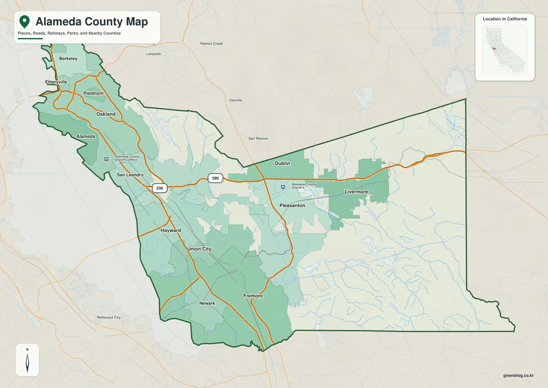
The county outline makes this contrast even clearer. The northwest around Berkeley and Oakland is narrow and closely tied to the shoreline, but south of the central hills the county widens dramatically and continues far east of Fremont. Alameda County is therefore much more than an urban strip on San Francisco Bay; a large share of its mapped area lies beyond the western city belt.
Dublin, Pleasanton, and Livermore occupy a separate inland valley system
Moving east from the Bay cities, the map passes through broad hill country before Dublin and Pleasanton appear. Livermore lies farther east and occupies another large developed area. Alameda County planning documents describe the county as extending from the Bay plain through the Diablo Range and into interior valleys. The separation between the western urban plain and the inland cities is visible even without a separate elevation layer.
Interstate 580 is the simplest road to use when tracing that shift. It crosses the central part of the county, enters the Dublin area, and continues east toward Livermore. Pleasanton lies just south of Dublin in the same broad interior valley. Compared with Oakland, San Leandro, or Hayward, the inland cities are surrounded by larger areas of open land and visible relief.
The eastern county continues well beyond Livermore toward the San Joaquin County side. Few large city labels appear there. Instead, small drainage lines and hill shading dominate the map, showing how quickly the landscape changes once the main Livermore developed area is left behind.
Oakland and Fremont lead the ranked city view, while Livermore stands apart in the east
The supplied city graphic ranks six major cities. Oakland is shown at 439,418, Fremont at 228,295, Hayward at 158,801, Berkeley at 102,257, San Leandro at 87,826, and Livermore at 85,522. These are comparison values printed in the supplied map rather than a replacement for current Census estimates, so up-to-date population work should use an official statistical source.
The distribution is more important than the ranking alone. Oakland, Berkeley, San Leandro, and Hayward are clustered along the Bay side of the county. Fremont forms a large southern center, while Livermore is the only ranked city placed far to the east beyond the central hills. The graphic therefore compresses Alameda County’s basic settlement pattern into one clear comparison: a dense western concentration plus a major inland city.
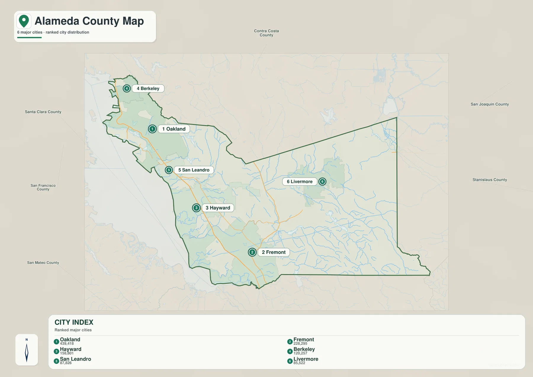
The graphic is intentionally selective. Dublin, Pleasanton, Alameda, Union City, Newark, Emeryville, and other mapped communities do not appear in the six-city ranking. Use this image for a quick comparison of major centers, then return to the county reference map when local connections and additional cities matter.
Alameda Creek links the interior hills with Fremont and San Francisco Bay
Alameda Creek is the most useful water feature for understanding the southwestern part of the county. East Bay Regional Park District describes its regional trail as following Alameda Creek from the mouth of Niles Canyon in Fremont west to San Francisco Bay. The terrain-and-water map shows the same relationship: the creek leaves a narrow hill corridor and spreads across the lower Fremont–Union City side before reaching the Bay.
Farther north, San Lorenzo Creek descends from the hills toward the shoreline, and Oakland Inner Harbor is labeled near the western urban area. San Francisco Bay fills the entire western edge of the water map. The relief shading changes quickly just east of the coastal plain, with ridges becoming much more obvious behind Oakland, San Leandro, and Hayward.
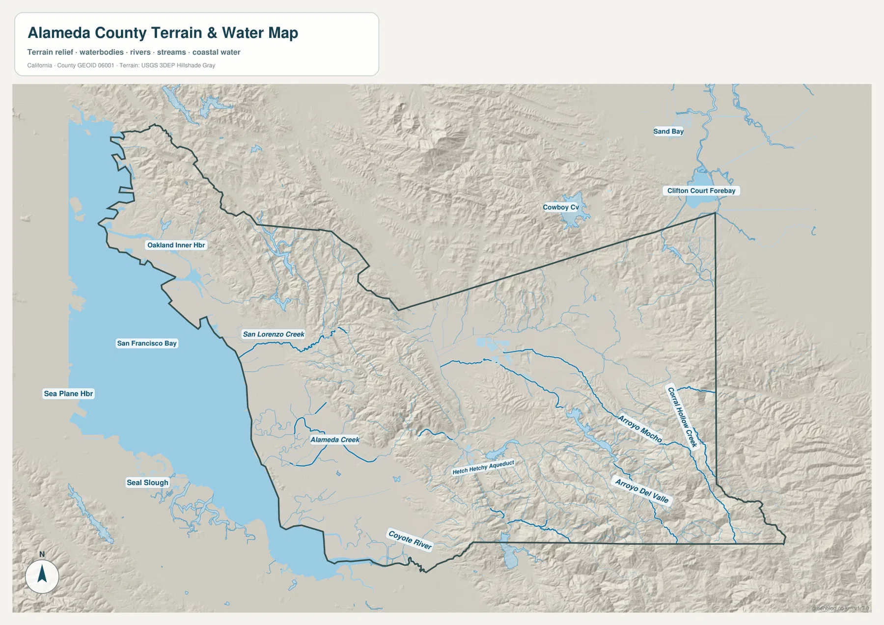
The park district calls Alameda Creek the largest creek in Alameda County and notes that its lower trail reaches about twelve miles from Niles to the Bay. That county-specific feature makes the creek a useful bridge between the physical and urban maps. Fremont sits where the hill drainage reaches the broad South Bay plain, and several transportation routes also use nearby lower corridors rather than crossing the highest ridges.
Arroyo Mocho and Arroyo Del Valle cross a very different eastern landscape
East of the central hills, the water map becomes less coastal and more valley-oriented. Arroyo Mocho crosses the Livermore area, while Arroyo Del Valle follows another long drainage south of it. Corral Hollow Creek is labeled near the far eastern boundary. Around these streams, the terrain is a mix of broader valley floors and surrounding ridges rather than the near-continuous urban plain seen beside San Francisco Bay.
Official Alameda County conservation material describes the Bay plain, East Bay hills, and Livermore–Amador valleys as major parts of the county’s geography. That description matches the supplied terrain image well. Pleasanton and Livermore occupy wider interior lowlands, while ridges rise around the valleys and continue toward the county’s rural eastern edge.
Near the northeast side, Clifton Court Forebay is labeled outside or close to the county boundary, and smaller streams continue toward the San Joaquin Valley side. This part of the map is far removed from Oakland’s shoreline setting. Seeing both ends of the county on the same terrain map is useful because it explains why a single “East Bay city” description does not capture Alameda County as a whole.
Read the county in three broad pieces: Bay plain, hill crossings, and inland valleys
A practical first pass is to begin with Oakland and move south through San Leandro, Hayward, and Fremont. That establishes the dense western city belt close to San Francisco Bay. Berkeley and Alameda provide additional shoreline reference points, while Newark and Union City help fill in the southern part of the same broad urban area.
Next, follow Interstate 580 east until Dublin and Livermore appear. The gap between the Bay cities and the inland cities is occupied by much more visible relief, making the county’s central hill barrier easy to recognize. Pleasanton sits south of Dublin in the interior valley, and Livermore expands the developed area farther east.
Finally, use Alameda Creek around Fremont to connect the urban and physical maps. The creek passes through the hill corridor and reaches the Bay plain, while Arroyo Mocho and Arroyo Del Valle organize the eastern interior. This approach keeps the county tied to a few real geographic relationships instead of turning the page into a long list of unrelated place names.
Choose the file according to whether you need cities, roads, or terrain and water
The county reference map is the best starting point for Berkeley, Oakland, Fremont, Dublin, Pleasanton, Livermore, highways, surrounding counties, and the boundary. The ranked city map is cleaner when the goal is to compare the major population centers. The terrain-and-water image provides the strongest view of San Francisco Bay, Alameda Creek, inland arroyos, and the hill-and-valley separation between western and eastern Alameda County.
For teaching or regional explanation, the reference and water maps work especially well as a pair. Oakland and Fremont can be placed within the low Bay-side urban belt, while Dublin and Livermore can be shown beyond the central hills. Alameda Creek gives a concrete example of a drainage route connecting interior terrain with the South Bay edge.
Each downloadable JPG measures 3638 × 2572 pixels and is suitable for A3 landscape printing, enlarging place labels, or inserting into reports and classroom handouts. Keep the original aspect ratio when resizing so the county boundary, roads, and waterways are not distorted. Printer margins vary, so testing one page before a larger print run is useful.
Frequently Asked Questions
What is the seat of Alameda County government?
Oakland is the seat of county government. Alameda County’s official website also identifies Oakland as its largest city. On the supplied reference map, Oakland sits near the center of the dense western Bay-side city belt between Berkeley and San Leandro.
Where does Alameda Creek appear on the map?
Alameda Creek crosses the southern part of the central hills and reaches the Fremont–Union City side before continuing toward San Francisco Bay. East Bay Regional Park District describes its lower trail as running from the Niles area in Fremont to the Bay.
Is an elevation map included in this Alameda County download?
No. This package contains the county reference map, city-distribution map, and terrain-and-water map. Relief is visible through hill shading on the terrain image, but there is no separate numeric elevation map in the supplied county package.
Map File Information
The ZIP contains the original Alameda County reference, city-distribution, and terrain-and-water maps as high-resolution JPG files.
- Included Files: County reference map, city-distribution map, terrain-and-water map
- Printable Size: 3638 × 2572 pixels each
- File Type: Three high-resolution JPG files in one ZIP archive
Related Maps
Sources and References
- Alameda County – About Us – Official county background, including Oakland as the county government seat and the county’s varied urban and open-space geography.
- Alameda County Sustainability – About Alameda County – Official overview of the county from San Francisco Bay through the East Bay hills to eastern inland areas.
- East Bay Regional Park District – Alameda Creek Regional Trails – County-specific information on Alameda Creek between Niles in Fremont and San Francisco Bay.
- Alameda County Geospatial Data Files – Official county geospatial resources and mapping disclaimer.
- USGS National Hydrography – Official information about U.S. rivers, streams, lakes, and hydrographic data.
Green Map creates custom-edited map images using open geographic data sources such as geoBoundaries, Natural Earth, OpenStreetMap, and government open data.
These maps are edited visual materials, not raw data files, and are provided for education, documents, presentations, and graphic reference.