Butte County crosses one of northern California’s clearest landscape transitions. Chico sits on the broad Sacramento Valley floor in the west, while Oroville lies farther southeast where the valley meets the foothills and the Feather River system. Paradise occupies higher ground between the two main urban areas, and the county continues far northeast into rugged Sierra Nevada terrain where rivers and steep canyons replace the dense road network of the valley.
You can download the original high-resolution A3 JPG files from this Butte County California Map page in one ZIP. The package contains a county reference map, ranked city-distribution map, and terrain-and-water map. There is no separate elevation map in this package, so descriptions of higher and lower terrain are based on the visible relief shading and verified Butte County geography rather than an invented elevation layer.
Table of Contents
Chico occupies the broad valley floor while Oroville sits at the foothill edge
Chico is the largest city shown in Butte County and the strongest urban center on the western side of the reference map. California State University, Chico is labeled within the city, Highway 99 runs north–south through the area, and Highway 32 heads east toward the foothills. The land around Chico looks broad and comparatively flat, with roads and smaller streams spreading across the Sacramento Valley rather than being confined to narrow mountain corridors.
South of Chico, Durham sits in the same valley setting, followed farther south by Biggs and Gridley. These communities are surrounded by much gentler terrain than the eastern half of the county. Highway 99 continues through the western corridor, while Highway 70 becomes the more important north–south route closer to Oroville and the southeastern valley edge.
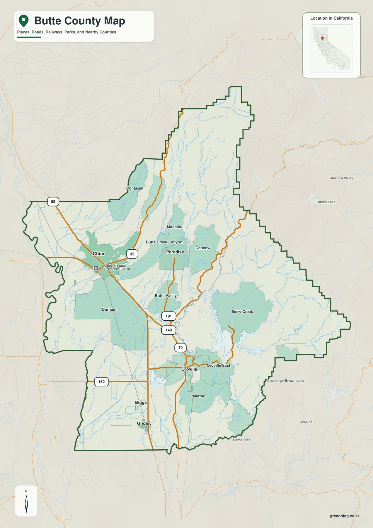
Oroville provides a different kind of reference point. A recent Butte County regional profile identifies Oroville as the county seat and describes it as the gateway to Lake Oroville and Feather River recreation. On the map, Oroville and Oroville East lie near Highway 70 and Route 162, with the reservoir and rugged drainage country immediately to the east. Chico anchors the valley city pattern; Oroville marks the transition into the Feather River foothills.
Paradise, Magalia, and Concow sit where the terrain becomes much rougher
Moving east from Chico, the map enters the Butte Creek Canyon area before reaching Paradise. Magalia is farther north, while Cohasset sits in another upland area northwest of the Paradise corridor. Roads become less dense and the terrain shading grows much stronger than it is around Chico, showing the shift from open valley land into dissected foothills.
Butte County’s General Plan divides the county into three broad topographic areas: valley, foothill, and mountain. The plan describes the valley as the broad western lowland, the foothills as the transition where communities such as Paradise occupy wooded higher ground, and the mountain region as the Sierra Nevada terrain farther east. The supplied maps match that progression clearly without requiring a separate elevation image.
Concow appears east of Paradise, and Berry Creek lies farther southeast within more rugged terrain. Beyond those communities, the northeastern county contains few large settlement labels. Instead, long ridges, narrow drainage lines, and Feather River tributaries dominate the map. This is one reason the county’s eastern half feels much larger than its city population alone would suggest.
The city map puts Chico far ahead of Oroville, Paradise, Gridley, and Biggs
The supplied city-distribution graphic ranks five incorporated cities or towns. Chico is shown at 102,188, Oroville at 19,752, Paradise at 7,392, Gridley at 7,330, and Biggs at 2,307. These are comparison values printed on the supplied image, not a substitute for the newest Census estimates. Current demographic work should use an official statistical source.
The geographic arrangement is as useful as the ranking. Chico stands alone as the largest western city, while Paradise lies east of it on higher foothill ground. Oroville sits southeast near the Feather River and Lake Oroville system. Gridley and Biggs form a smaller southern pair on the flatter valley floor. All five ranked communities are concentrated in the western and southern portions of the county rather than the remote northeastern mountains.
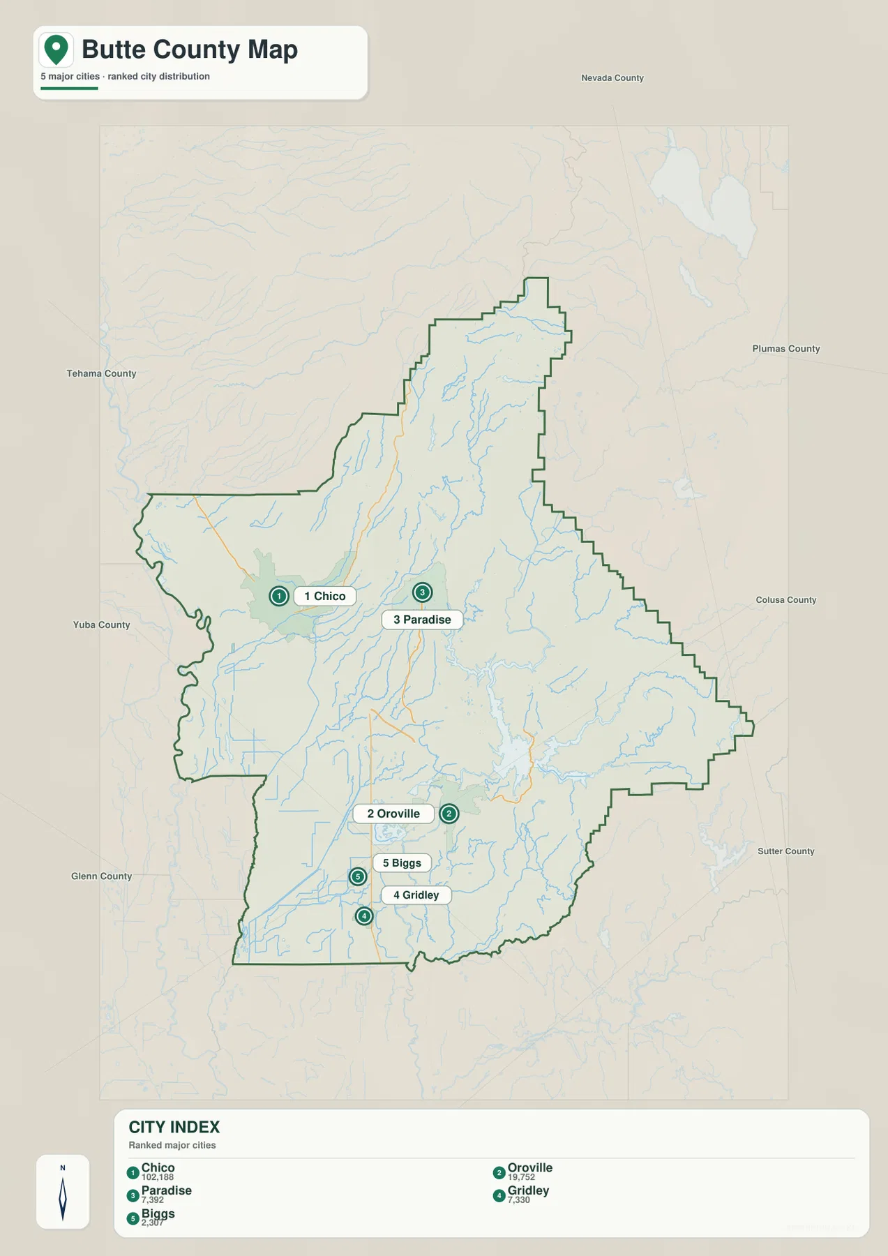
The reference map includes additional communities such as Durham, Magalia, Cohasset, Concow, Butte Valley, Palermo, and Oroville East. That makes the city graphic best for relative size and broad placement, while the county map is better when smaller places, highways, and nearby counties matter.
Lake Oroville gathers several major Feather River branches in the eastern foothills
Lake Oroville is the dominant water feature on the terrain map. California State Parks explains that the reservoir was created by Oroville Dam on the Feather River. Its long arms extend into several mountain valleys, and the map labels the North Fork Feather River and Middle Fork Feather River approaching from the east and northeast.
Immediately west of the reservoir, the water system becomes more engineered and open. Thermalito Diversion Pool, Thermalito Forebay, and Thermalito Afterbay are labeled between Oroville and the lower valley. These features provide a useful visual bridge between the deeply cut reservoir arms in the foothills and the much flatter lowland south and west of Oroville.
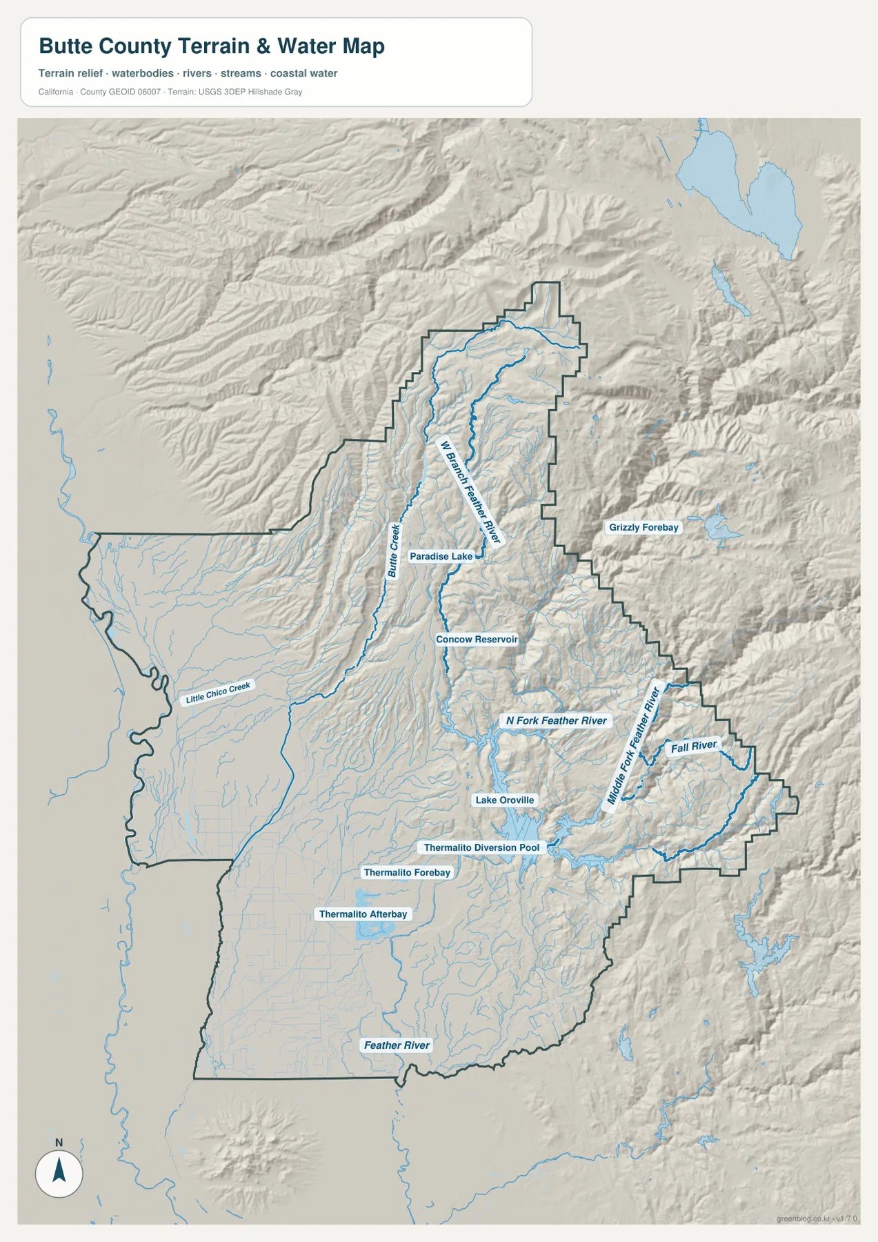
North of Lake Oroville, the West Branch Feather River follows a long mountain corridor. Fall River appears farther east, and many smaller tributaries cut through closely spaced ridges. The water map is especially valuable here because the river network explains the shape of the terrain: streams occupy deep canyons, while roads and settlement labels become sparse away from the valley floor.
Butte Creek and Little Chico Creek connect the foothills with the Chico side of the valley
Chico’s side of the county has a different water pattern from the Lake Oroville mountains. Butte Creek descends from the foothills through the Butte Creek Canyon area, and Little Chico Creek continues across lower ground toward the western valley. These channels spread into a broader landscape rather than remaining confined between steep ridges.
Paradise Lake and Concow Reservoir provide useful water landmarks in the central foothills. Paradise Lake lies north of Paradise, while Concow Reservoir is farther east within rougher terrain. Butte County’s General Plan notes that water from the Sierra Nevada feeds the valley through the Feather River, Sacramento River, and Butte Creek systems. The terrain map makes that east-to-west connection easy to see.
This image is a county-scale terrain and water reference rather than a flood-hazard, parcel, navigation, or water-quality map. It is appropriate for locating rivers, reservoirs, creeks, and valleys and comparing them with towns and roads. Current safety or recreation information for Lake Oroville should be checked with California State Parks or the responsible water agencies.
The southwest is a low valley while the northeast rises into the Sierra Nevada
Even without a separate elevation map, the relief difference across Butte County is unmistakable. Chico, Durham, Biggs, and Gridley occupy broad, lightly shaded lowland terrain. East of Paradise and north of Lake Oroville, ridges become closely packed and river valleys cut much deeper into the landscape. The county’s northeast is overwhelmingly mountainous in the supplied terrain image.
Butte County’s General Plan gives useful official context for that visual contrast. It describes the county as extending from roughly 60 feet above sea level near the southwestern Sacramento River side to about 8,100 feet in the northeast, with distinct valley, foothill, and mountain zones. Those figures come from the county planning source, not from a missing elevation layer in this package.
Paradise is a particularly useful midpoint. A Butte County regional profile describes the town as lying on a ridge at roughly 2,000 to 2,800 feet, while Chico occupies the much lower valley to the west. Continuing east from Paradise brings Concow, Berry Creek, Lake Oroville tributaries, and increasingly rugged Sierra terrain into view. That sequence makes the county’s elevation transition easy to understand from the maps that are actually provided.
Use Chico and Oroville as anchors before moving into the mountain interior
A first-time reader can begin with Chico on the western side and Oroville farther southeast. From Chico, follow the valley south through Durham toward Biggs and Gridley, then look east toward Butte Creek Canyon and Paradise. From Oroville, switch to the terrain map and locate Lake Oroville, the Thermalito facilities, and the Feather River branches.
Once those two city anchors are familiar, the northeastern half becomes easier to interpret. Cohasset and Magalia mark the foothill-to-mountain transition north of Chico, while Concow and Berry Creek provide inland references closer to the Feather River country. Farther northeast, waterways and ridges become more useful than town names for understanding position.
Choose the map according to whether you need cities, roads, or river terrain
The county reference map is the best starting point for Chico, Oroville, Paradise, smaller communities, highways, nearby counties, and the boundary. The ranked city map works well when the relative size and location of Chico, Oroville, Paradise, Gridley, and Biggs are the main questions. The terrain-and-water map is the strongest choice for Lake Oroville, the Feather River branches, Thermalito facilities, Butte Creek, and the deep northeastern canyons.
For teaching or regional explanation, the reference and terrain maps work especially well together. Chico can be shown on the broad Sacramento Valley floor, Paradise at the foothill transition, and Oroville beside the Feather River system. Moving farther east on the terrain image then shows how rapidly roads and cities give way to mountain drainage and rugged relief.
Each downloadable JPG measures 2572 × 3638 pixels and is suitable for A3 portrait printing, enlarging place labels, or placing a map in a report or classroom handout. Keep the original aspect ratio when resizing so roads, rivers, and the county boundary are not distorted. Printer margins vary, so checking one test page before a larger print run is useful.
Frequently Asked Questions
Is Chico or Oroville the county seat of Butte County?
Oroville is the county seat. Chico is the larger city, but county government is centered in Oroville. On the reference map, Chico occupies the western valley floor while Oroville sits farther southeast near the Feather River and Lake Oroville.
How is Lake Oroville connected to the Feather River?
Lake Oroville was created by Oroville Dam on the Feather River. The supplied terrain map shows major branches, including the North Fork and Middle Fork Feather River, feeding into the reservoir area, with Thermalito water facilities immediately to the west.
Does this Butte County download include a separate elevation map?
No. The package contains the county reference map, city-distribution map, and terrain-and-water map. The relief shading clearly shows the valley-to-Sierra transition, but no separate numeric elevation map is included.
Map File Information
The ZIP contains the original Butte County reference, city-distribution, and terrain-and-water maps as high-resolution JPG files.
- Included Files: County reference map, city-distribution map, terrain-and-water map
- Printable Size: 2572 × 3638 pixels each
- File Type: Three high-resolution JPG files in one ZIP archive
Related Maps
Sources and References
- Butte County General Plan 2030 – Official county description of the Sacramento Valley, foothills, Sierra Nevada mountain region, and elevation range.
- Butte County Regional Profile – County-specific information on Chico, Oroville, Paradise, Gridley, Biggs, and Oroville as the county seat.
- California State Parks – Lake Oroville State Recreation Area – Official information about Lake Oroville, Oroville Dam, and the Feather River setting.
- USGS National Hydrography – Official U.S. river, stream, lake, and hydrographic data information.
Green Map creates custom-edited map images using open geographic data sources such as geoBoundaries, Natural Earth, OpenStreetMap, and government open data.
These maps are edited visual materials, not raw data files, and are provided for education, documents, presentations, and graphic reference.