Calaveras County stretches from lower Sierra Nevada foothills in the west into rugged mountain country in the east. San Andreas is the county seat, while Angels Camp is the county’s only incorporated city. Highway 4 provides a useful east–west route through Copperopolis, Angels Camp, Murphys, Arnold, and Dorrington, and the map becomes progressively less urban as that road climbs toward the Sierra. By the eastern end, river valleys and mountain drainage lines are more useful landmarks than town names.
You can download the original high-resolution A3 JPG files from this Calaveras County Map page in one ZIP. The package contains a county reference map, city-distribution map, and terrain-and-water map. There is no separate elevation map in this package, so the terrain discussion stays with the visible relief shading, river valleys, reservoirs, and verified county geography rather than adding an unsupported elevation layer.
Table of Contents
San Andreas is the county seat, but Angels Camp is the only incorporated city
San Andreas is the administrative center of Calaveras County. The county’s current administrative history notes that San Andreas has remained the county seat since 1863. On the reference map it sits in the western interior near Highways 49 and 26, with Mountain Ranch to the east and Rancho Calaveras to the southwest. Its central foothill position makes it a practical place to begin reading the county.
Angels Camp plays a different role. Calaveras County’s official administrative material identifies it as the county’s only incorporated city. The reference map labels Angels southeast of San Andreas where Highway 49 meets Highway 4. This distinction explains why the county has an important seat of government that does not appear as an incorporated city on the ranked city graphic.
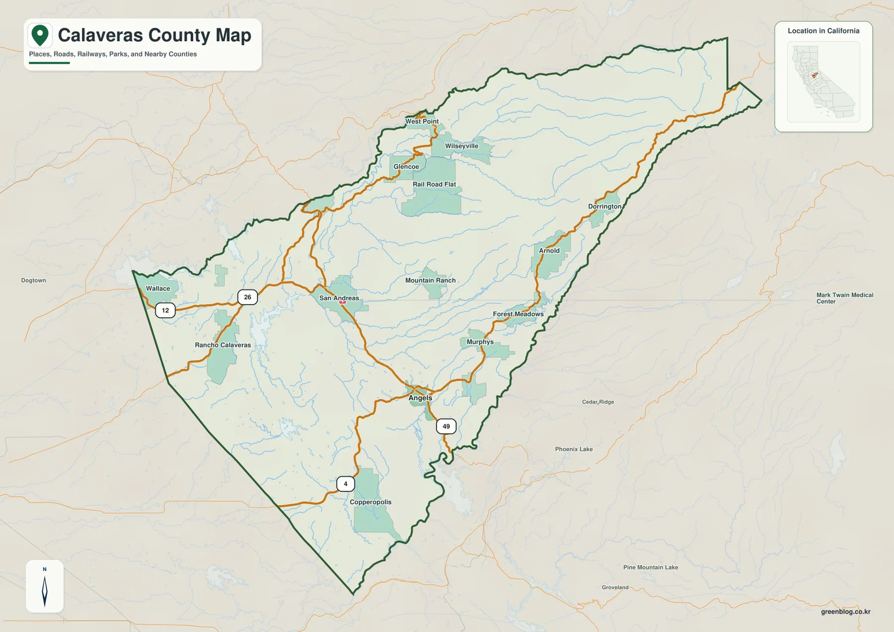
Northwest of San Andreas, Wallace and Rancho Calaveras sit closer to the lower foothill side. West Point, Wilseyville, Glencoe, and Rail Road Flat form a looser northern group reached by mountain roads rather than a dense street network. South and southeast of San Andreas, Highway 49 leads toward Angels Camp, where the road pattern changes again because Highway 4 turns east toward the Sierra.
Highway 4 gives the clearest west-to-east view of Calaveras County
Highway 4 crosses much of the county and is one of the easiest features to use for orientation. Copperopolis sits near the western end of the mapped corridor. Moving east brings Angels Camp, then Murphys, Forest Meadows, Arnold, and Dorrington. The surrounding map becomes noticeably rougher along that sequence, with fewer broad developed areas and more tightly spaced drainage lines.
That route makes the county’s changing settlement pattern easy to see. Copperopolis and Angels Camp lie in the lower foothills, Murphys is farther into the upland belt, and Arnold and Dorrington occupy a much more mountainous setting. East of Dorrington, town labels become sparse while the county boundary continues far into the Sierra, showing how much of Calaveras County lies beyond its better-known Gold Country communities.
Calaveras Big Trees State Park provides useful official context for the Arnold side of the map. California State Parks describes the park as a mixed-conifer forest with giant sequoia groves, the Stanislaus River, Beaver Creek, volcanic formations, and mountain meadows. Those features fit the visibly rugged eastern terrain around the Highway 4 corridor without requiring a separate elevation map.
The city map contains one ranked city because Angels Camp is the only incorporated municipality
The supplied city-distribution graphic is unusually simple. It shows one ranked major city, labeled `Angels`, with a value of 3,716. Calaveras County’s official administrative history identifies Angels Camp as the county’s only incorporated city, so the shortened map label can reasonably be read as Angels Camp. The city view therefore reflects the county’s municipal structure rather than omitting a large group of incorporated towns.
San Andreas is absent from the ranked city graphic because it is an unincorporated community even though it is the county seat. The same is true for many familiar names on the reference map, including Murphys, Arnold, Copperopolis, West Point, and Mountain Ranch. This is a county where the reference map is essential because a municipal ranking alone would hide many of the places people actually use for local orientation.
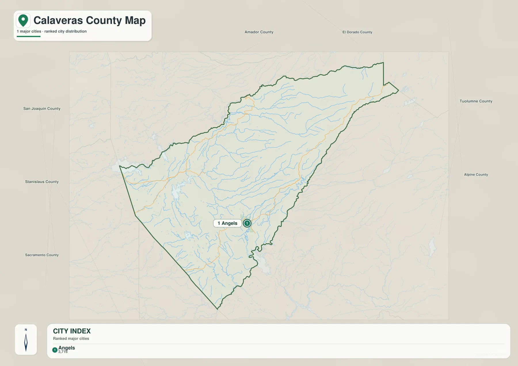
The number printed on the supplied graphic should be treated as a comparison value in the image rather than the latest Census estimate. For current population work, use an official statistical source. The more important lesson here is administrative: county seat and incorporated city are not the same category in Calaveras County.
The Mokelumne and Stanislaus systems frame the county from north and south
Calaveras County’s river geography is organized around three major systems. The county’s General Plan environmental analysis says the Mokelumne River forms the northern boundary with Amador County, while the Stanislaus River forms the southern boundary. Between them lies the Calaveras River watershed, which drains much of the western and central interior.
On the terrain-and-water map, the South Fork and Middle Fork Mokelumne River are labeled across the northern Sierra side. The North Fork Stanislaus River follows a major southern mountain corridor. These waterways descend westward from the Sierra through deep valleys, helping explain the long, narrow shape of the county and the many ridges that run between drainage basins.
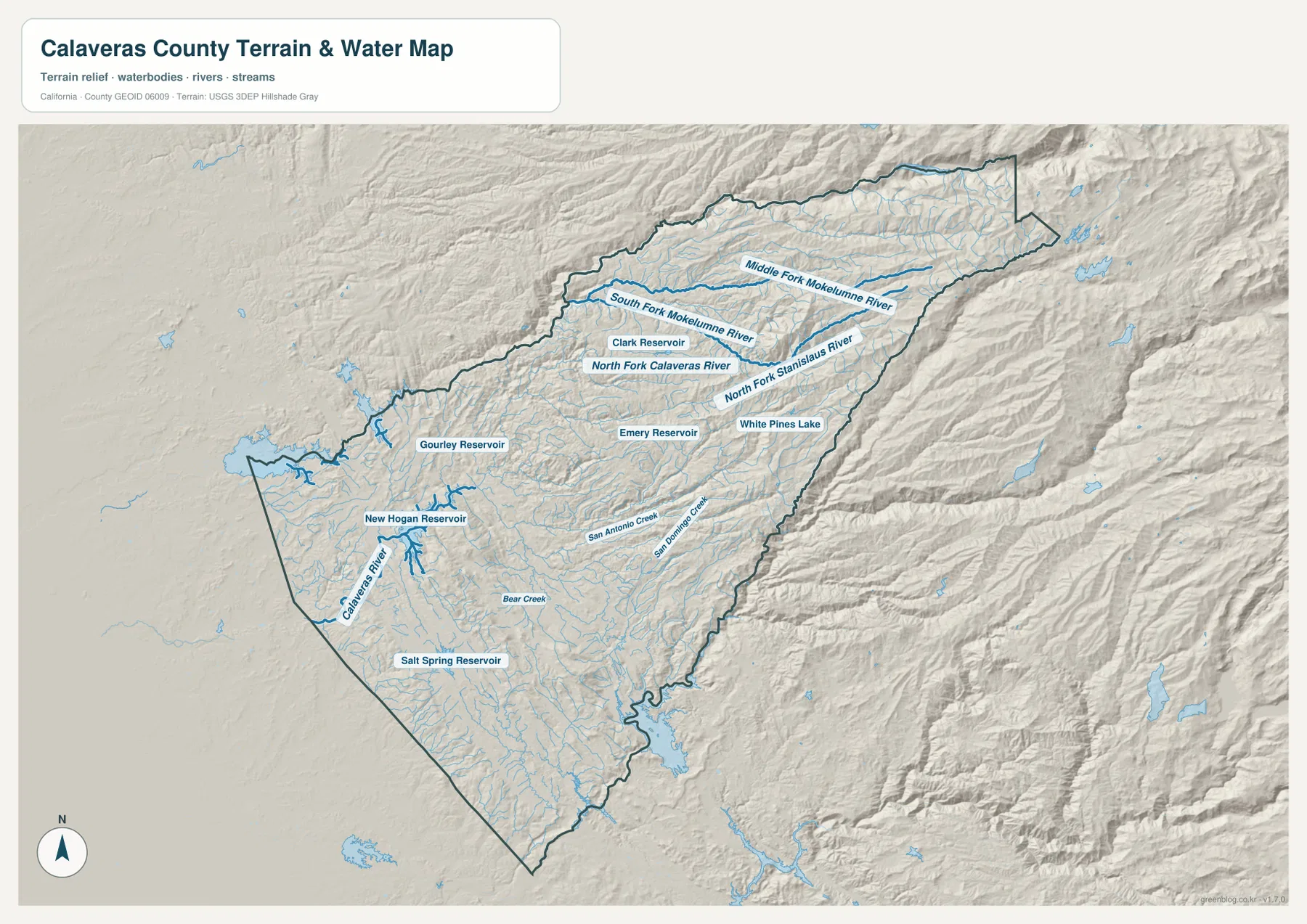
Several smaller water bodies help break down the large Sierra section. Clark Reservoir is labeled in the northern interior, with Emery Reservoir and White Pines Lake farther south and east. White Pines Lake provides a useful local landmark near the Arnold area. Beyond these places, small streams become more numerous and settlement labels become less frequent, making water and relief better guides than towns.
New Hogan Reservoir marks the Calaveras River system in the western foothills
The Calaveras River is the central river system to follow in the western half of the county. The county’s hydrology analysis describes the river as flowing generally west-southwest from the Sierra and identifies North and South Fork branches in the upper watershed. On the supplied map, the North Fork Calaveras River is labeled above the central foothills and the main river continues toward New Hogan Reservoir.
New Hogan Lake is particularly useful because its river relationship is documented by the U.S. Army Corps of Engineers. The Corps says the lake is on the Calaveras River and, when full, extends nearly eight miles upstream to the confluence area of the north and south forks. The terrain map shows the reservoir as a large western water feature with the Calaveras River continuing downstream toward the county edge.
Salt Spring Reservoir lies farther south, while San Antonio Creek, San Domingo Creek, and Bear Creek cross the central and southwestern foothills. These smaller streams help explain why the terrain between Angels Camp and Copperopolis is cut into many modest ridges and valleys rather than forming one broad flat surface.
Roads are the best guide in the foothills; rivers become better guides in the high Sierra
For a first reading of the county, locate San Andreas and Angels Camp before moving outward. Highway 49 connects those two major reference points, Highway 26 reaches toward the West Point side, and Highway 4 runs east through Murphys and Arnold. This creates a simple road framework for the western and central foothills where most named communities appear.
East of Arnold, the map changes. Large place labels fade while the Mokelumne and Stanislaus tributaries, narrow valleys, and ridges become more prominent. In that part of the county, it is easier to orient yourself with river basins and the main Highway 4 corridor than with settlement names. The map therefore rewards a different reading method as you move east.
Neighboring county labels provide another reference. Amador County is north of Calaveras County, Tuolumne and Stanislaus counties are to the south, San Joaquin County is west, and Alpine County meets the narrow eastern end. The boundary becomes especially narrow in the high Sierra, so following the dark county outline is important when nearby roads or waterways approach adjacent counties.
Use the reference map for communities and the terrain map for the river basins
The county reference map is the strongest choice for San Andreas, Angels Camp, Copperopolis, Murphys, Arnold, West Point, and the numbered highways. The city graphic answers a narrower question because it reflects the county’s single incorporated city. For local geography beyond municipal boundaries, the reference map provides much more useful detail.
The terrain-and-water map is better when rivers, reservoirs, and mountain valleys are the main subject. New Hogan Reservoir and the Calaveras River explain the western watershed, while the Mokelumne and Stanislaus systems frame the northern and southern Sierra sides. The eastern county also makes more sense on this image because the map emphasizes drainage and relief where town labels are scarce.
Each downloadable JPG measures 3638 × 2572 pixels and is suitable for A3 landscape printing, enlarging small place labels, or inserting into reports and classroom handouts. Keep the original aspect ratio when resizing so roads, waterways, and the county boundary are not distorted. Printer margins vary, so checking one test page before a larger print run is useful.
Frequently Asked Questions
Is Angels Camp the county seat of Calaveras County?
No. San Andreas is the county seat. Angels Camp is the county’s only incorporated city, while San Andreas is an unincorporated community that serves as the administrative center. That is why the ranked city map can show Angels Camp without showing the county seat.
Which river is New Hogan Lake on?
New Hogan Lake is on the Calaveras River. The U.S. Army Corps of Engineers states that the reservoir extends upstream toward the area where the north and south forks of the Calaveras River come together.
Does this download include a separate elevation map?
No. This Calaveras County package contains the county reference map, city-distribution map, and terrain-and-water map. Mountain relief is visible through shaded terrain, but there is no separate numeric elevation map in the supplied package.
Map File Information
The ZIP contains the original Calaveras County reference, city-distribution, and terrain-and-water maps as high-resolution JPG files.
- Included Files: County reference map, city-distribution map, terrain-and-water map
- Printable Size: 3638 × 2572 pixels each
- File Type: Three high-resolution JPG files in one ZIP archive
Related Maps
Sources and References
- Calaveras County Administrative Manual – History – Official county history confirming San Andreas as the county seat and Angels Camp as the only incorporated city.
- Calaveras County General Plan Draft EIR – Hydrology – Official county information on the Mokelumne, Calaveras, and Stanislaus river systems.
- U.S. Army Corps of Engineers – New Hogan Lake – Official information on New Hogan Lake and its relationship with the Calaveras River.
- California State Parks – Calaveras Big Trees State Park – Official background on the giant sequoia forest, Stanislaus River, Beaver Creek, and eastern Sierra setting near Arnold.
- Calaveras County GIS – Official county geographic data and mapping services.
Green Map creates custom-edited map images using open geographic data sources such as geoBoundaries, Natural Earth, OpenStreetMap, and government open data.
These maps are edited visual materials, not raw data files, and are provided for education, documents, presentations, and graphic reference.