Kanabec County lies in east-central Minnesota, with Mora as its main southern-center reference, Ogilvie to the southwest, Quamba to the northeast, and Grasston to the southeast. The Snake River winds through the middle of the county, while higher terrain occupies much of the northwest. The contrast between the river valley and the uplands becomes especially clear when the water and elevation maps are compared.
This page uses the supplied county, city-connection, water, and elevation maps to explain those relationships with the actual places shown in the package. Original high-resolution JPG versions of all four views are also available together in one ZIP download for printing, classroom work, presentations, or image editing.
Table of Contents
Mora provides the clearest road reference
Mora is the easiest place to begin on the general county map. Highway 65 runs through the city from north to south, while Highway 23 approaches from the Ogilvie side and continues east toward Quamba. The larger mapped urban area around Mora makes it a natural anchor for locating the rest of Kanabec County.
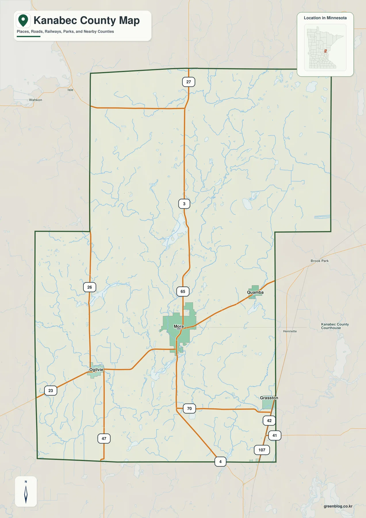
Highway 23 leads southwest from Mora toward Ogilvie, while Quamba lies northeast of the city toward the Pine County side. Grasston is southeast of Mora and can be located with Highway 70 and the road network near the eastern boundary. Highway 47 runs north-south in the southwest, and Highway 26 appears farther west, providing alternatives to routes that pass through Mora.
The north has much wider spacing between roads and almost no large town labels. Highway 65 continues through the middle, and Route 27 appears near the northern part of the county. Streams, wetlands, and small lakes become more visually prominent than settlement names, giving the north a very different character from the Mora-centered south.
The boundary is fairly simple across the north but includes noticeable steps in the southwest and southeast. Mille Lacs, Isanti, and Chisago counties provide western and southwestern context, while Pine County borders the east. The map is intended for geographic orientation rather than live traffic information, so road construction, closures, and current travel times should be checked separately.
Straight-line distances from Mora to Ogilvie, Grasston, and Quamba
The city-connection map simplifies the southern half around four communities. Mora is the hub, Ogilvie lies southwest, Quamba is northeast, and Grasston sits southeast. The three smaller communities point in different directions from Mora rather than forming a single linear corridor, which makes this view useful for quick orientation.
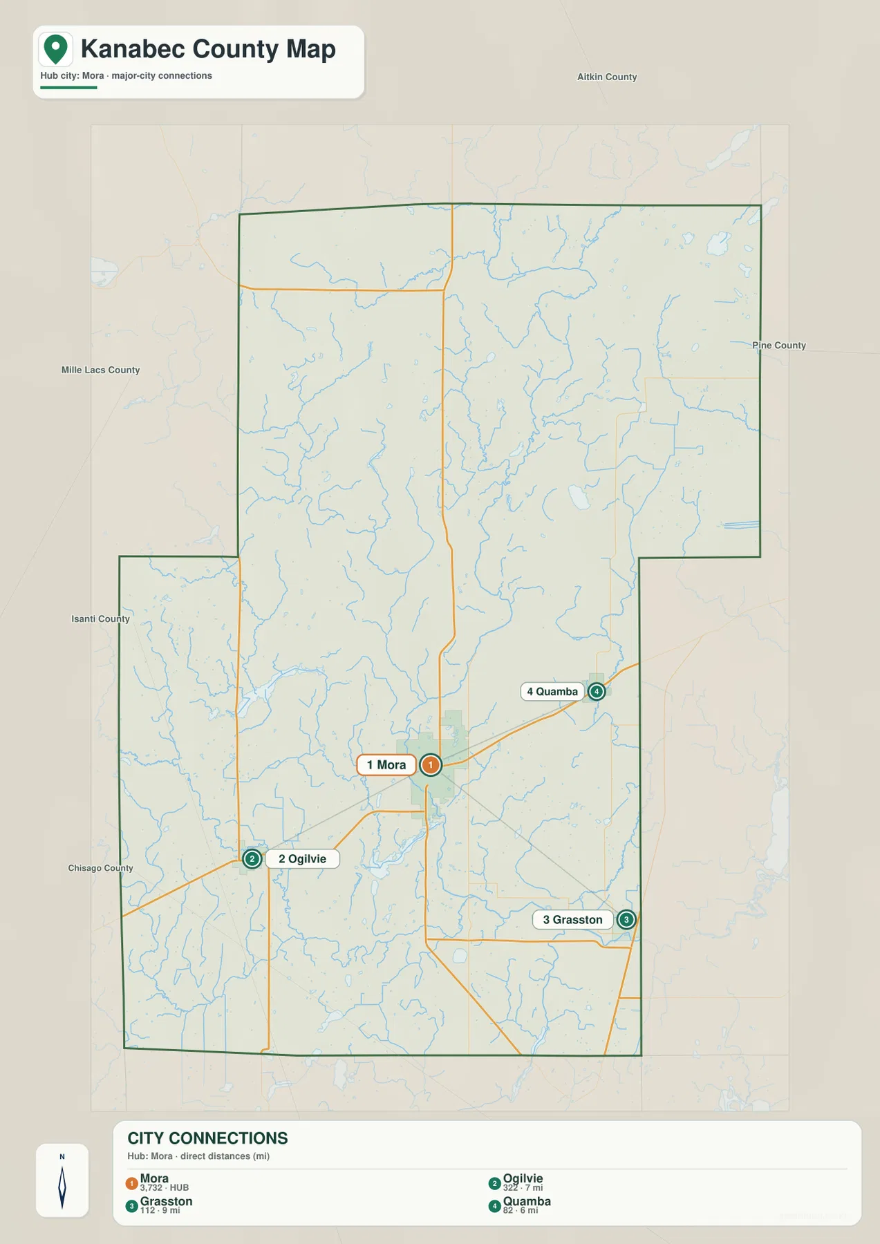
The CITY CONNECTIONS panel lists Mora at 3,732, Ogilvie at 322, Grasston at 112, and Quamba at 82. It also labels Mora-to-Ogilvie at 7 miles, Mora-to-Grasston at 9 miles, and Mora-to-Quamba at 6 miles. These are straight-line distances between mapped points, not road-mile calculations, so actual driving routes can be longer.
The city numbers should be treated as index values printed on the supplied map rather than as claims about the latest official population estimates. Their main value is comparative: Mora is represented as the dominant center, while the other three communities are much smaller and distributed around it.
Kanabec County’s official website also identifies the courthouse and county offices at 317 Maple Avenue East in Mora and links to GIS Mapping and Snake River Watershed resources. That makes Mora a useful administrative reference point as well as the central mapped road hub.
The Snake River forms the county’s central water corridor
The Snake River is the most prominent waterway on the supplied water map. It enters from the north, winds down through the center of the county, passes the Mora area, and continues through the southern part before turning eastward. Several tributaries join the river along the way, making the central and southern portions of Kanabec County part of one broad river system.
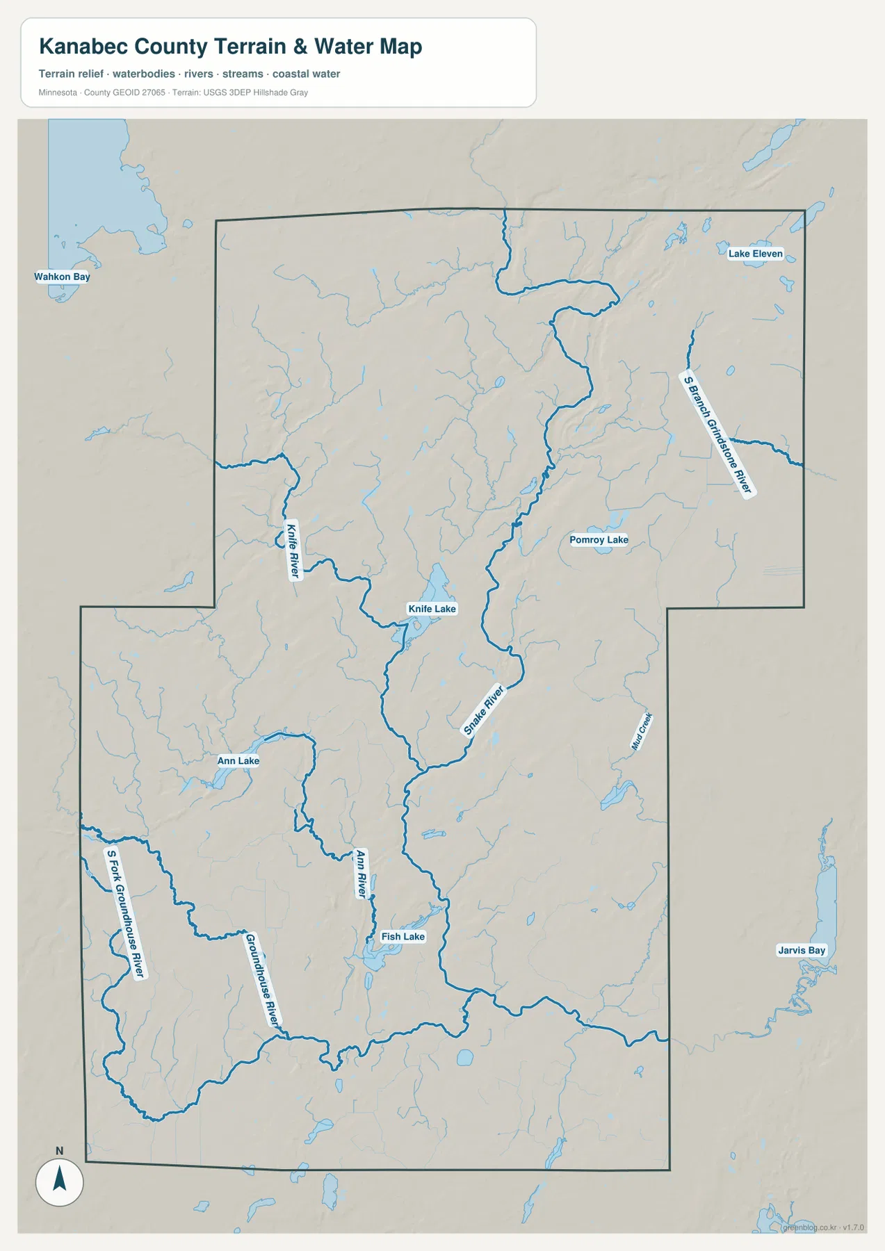
Minnesota DNR describes the Snake River State Water Trail as an 84-mile route from the McGrath area to its confluence with the St. Croix River. Its segment guide notes that the river between Mora and Pine City changes from wooded banks toward a broader farming valley. That description fits the supplied county map, where the river passes Mora and continues southeast toward the Pine County side.
Knife River approaches from the west and passes close to Knife Lake before joining the central system. Farther south, Ann River and Groundhouse River are clearly labeled, with S Fork Groundhouse River crossing the southwestern part of the county. These tributaries make the western and southern drainage more complex than a map focused only on the Snake River would suggest.
The northeastern and eastern edges have separate named waterways as well. S Branch Grindstone River appears in the northeast, and Mud Creek is labeled farther south along the eastern side. Those streams provide useful reference points for parts of the county that sit away from the main Snake River valley.
Knife Lake, Fish Lake, and scattered smaller waters
Kanabec County has many medium and small water bodies rather than one dominant lake. Knife Lake is one of the clearest labels in the west-central interior, while Ann Lake lies farther southwest. Fish Lake appears south of Mora near the lower Snake and Ann River area, making it another useful landmark for the central-southern part of the county.
Pomroy Lake is labeled east of the county center, and Lake Eleven appears in the northeast. Wahkon Bay is shown outside the northwestern boundary and Jarvis Bay appears outside the eastern side, so those external waters should not be confused with lakes entirely inside Kanabec County. Even within the boundary, the number of small lakes and streams shows how widely water is distributed.
The water map is intended for location and geographic context. It does not provide flood-hazard zones, water depth, legal shoreline access, parcel boundaries, or fishing regulations. Paddlers on the Snake River should consult Minnesota DNR water-trail information and current river levels, while land and property questions should rely on county GIS and official records.
A 287–401 meter range from northwest uplands to river lowlands
The supplied elevation map reports an actual county range of about 287 to 401 meters, with a mean near 329 meters. The highest brown terrain occupies much of the northwest and extends into the west-central interior. Greens become more common toward the east and southeast, while the Snake River valley forms a long lower corridor through the center and south.
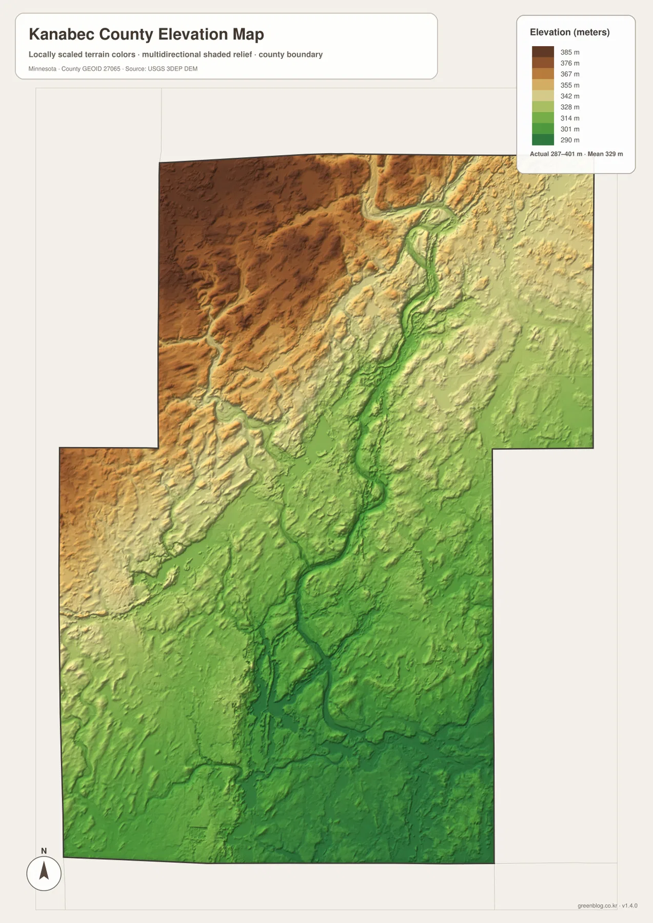
The northwestern high area is broad but not flat. Small creek valleys and rolling ridges divide the brown surface, and the land steps downward toward the center of the county. Moving from the Mille Lacs County side toward Mora reveals one of the clearest county-wide elevation changes on the map.
The Snake River is especially easy to match between the water and elevation views. A green low corridor follows the river from the north through the central interior and toward Mora, then broadens across the southern section. Narrower lows also follow tributaries such as Knife River and Ann River, making the relationship between water and terrain visually consistent.
The eastern half is lower overall than the northwest but still contains rolling terrain. S Branch Grindstone River occupies a narrow low feature in the northeast, while the Grasston side in the southeast shows a broader field of green lower ground. Kanabec County therefore has a clear northwest-to-southeast difference without being a simple, uniformly sloping surface.
This elevation surface is appropriate for county-scale comparison, not surveying or engineering. It should not be used for exact building elevations, road grades, drainage design, or parcel-level contour decisions. Detailed USGS 3D Elevation Program products or professional survey data are the better sources when precision matters.
Why Mora is a useful place to compare roads, water, and relief
Mora combines several of the county’s strongest geographic features in one area. Highways 65 and 23 meet nearby, the Snake River passes through the same general corridor, and the elevation map shows lower terrain along the river. That overlap makes Mora the easiest place to connect the road, city, water, and relief maps without relying on abstract geographic descriptions.
Ogilvie, Grasston, and Quamba show how the surrounding settings differ. Ogilvie lies southwest of Mora and closer to the transition toward the higher western interior. Quamba is northeast toward the Pine County side, while Grasston sits southeast in broader lower terrain. All three are relatively close to Mora on the city map, but their nearby waterways and elevations are not the same.
North of Mora, place names become less frequent and natural features become more useful for orientation. The high northwest, the Snake River valley, and the S Branch Grindstone River side create three distinct references. This is why the county’s northern half is better understood through the water and elevation maps than through settlement labels alone.
Choosing a map for roads, town connections, water, or relief
Use the general county map when Mora, Ogilvie, Grasston, Quamba, and the numbered roads need to appear together. The city-connection view is better for a quick comparison of the three direct distances from Mora. Because the labeled 6-to-9-mile connectors are straight-line measurements, they should not be substituted for actual driving mileage.
The water map is the stronger choice for the Snake River, Knife River, Ann River, Groundhouse River, and the county’s named lakes. Pair it with the elevation map when the goal is to show how the Snake River occupies lower terrain and how strongly the northwest rises above the Mora-Grasston side of the county.
For printing or image editing, the original JPG files in the ZIP provide more resolution than the WebP previews embedded in this article. Each JPG measures 2572 by 3638 pixels, and the archive contains the county, city, water, and elevation maps.
Official Kanabec County and Minnesota sources for detailed work
Kanabec County’s official website provides county departments, GIS Mapping, highway and survey information, and a dedicated Snake River Watershed page. Parcel boundaries, taxes, permits, official road records, and other administrative decisions should rely on those current county tools rather than on a general-purpose overview map.
Minnesota DNR’s Snake River State Water Trail is the better source for river segments, paddling conditions, and current water-trail guidance. U.S. Census Bureau TIGER/Line files support boundary and road work, USGS National Hydrography provides water data, and the USGS 3D Elevation Program provides detailed elevation products.
Frequently Asked Questions
Are the Mora-to-Ogilvie, Grasston, and Quamba distances road miles?
No. The city map labels Mora-to-Ogilvie at 7 miles, Mora-to-Grasston at 9 miles, and Mora-to-Quamba at 6 miles, but those are straight-line distances between mapped points. Actual road mileage can be longer.
Where does the Snake River run through Kanabec County?
The supplied water map shows the Snake River entering from the north, winding through the central county and Mora area, and continuing through the south before turning eastward. Knife River and Ann River are among the tributaries shown joining the central system.
Where is the highest terrain in Kanabec County?
The supplied elevation map shows an overall range of about 287–401 meters with a mean near 329 meters. The highest ground is concentrated in the northwest, while the Snake River valley and the southeast are lower. Exact site elevations require detailed USGS data or survey information.
Map File Information
Download the original high-resolution JPG versions of the Kanabec County maps shown on this page in one ZIP file.
- Included Files: county map, city map, water map, elevation map
- Printable Size: each JPG is 2572 × 3638 px
- File Type: ZIP containing 4 JPG files
Related Maps
Sources and references
- Kanabec County official website – county government, GIS Mapping, highway, survey, and local information
- Kanabec County Snake River Watershed – local watershed management information
- Minnesota DNR Snake River State Water Trail – river route, segment, and paddling information
- U.S. Census Bureau TIGER/Line Shapefiles – boundary, road, and place data
- USGS National Hydrography – river, stream, and water data
- USGS 3D Elevation Program – elevation data and products
Green Map creates custom-edited map images using open geographic data sources such as geoBoundaries, Natural Earth, OpenStreetMap, and government open data. These maps are edited visual materials, not raw data files, and are provided for education, documents, presentations, and graphic reference.