Osborne County sits in north-central Kansas, where the city of Osborne provides the clearest road reference for a group of small communities spread across two Solomon River valleys. US 24 runs across the northern half of the county, US 281 passes through the Osborne area, and K-181 becomes important near Downs. The South Fork Solomon River cuts a broad central valley, while the North Fork Solomon River creates a separate low corridor around Portis and the northeastern side. High-resolution map files are available for download in the section below.
This guide follows Osborne, Downs, Alton, Natoma, and Portis across the supplied maps, with terrain ranging from about 444 to 637 meters. WebP previews are available for quick viewing, and the matching high-resolution JPG files can be downloaded together in one ZIP for printing, classroom work, or offline reference.
Table of Contents
Osborne sits where US 24 and US 281 organize the county road network
Osborne is close to the center of the northern half of the county and sits near the meeting of US 24 and US 281. US 24 provides the strongest east–west reference, leading toward Alton on one side and Downs on the other. US 281 creates the main north–south route through the Osborne area and continues toward Portis.
Downs has a different road pattern. US 24 and K-9 meet K-181 there, making the city an important eastern junction. Osborne County’s own map page identifies US 24 as the principal east–west route and US 281 and K-181 as the main north–south highways, which matches the structure visible on the supplied county map.
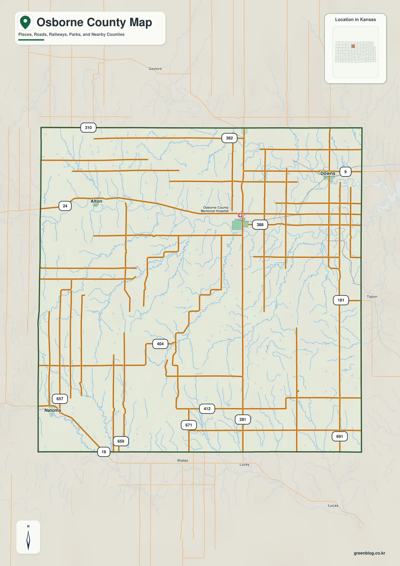
The official county site places government offices in Osborne, reinforcing the city’s role as both the administrative center and the most useful geographic reference. The surrounding towns are separated by large areas of farmland, local roads, and creek valleys rather than one continuous built-up corridor.
Portis and Downs are closest to Osborne, while Natoma sits much farther away
The city-connections panel marks Osborne as the hub with an index value of 1,358. Portis is listed at 70 and about 8 direct miles away, Downs at 749 and about 9 miles, Alton at 121 and about 13 miles, and Natoma at 427 and about 25 miles.
These are map index values rather than current official population estimates, and the mileage figures are straight-line distances rather than driving distances. The locations also matter: Portis is north of Osborne, Downs is east, Alton is west, and Natoma lies in the southwest. Road travel therefore depends on different corridors even when two towns have similar direct distances.
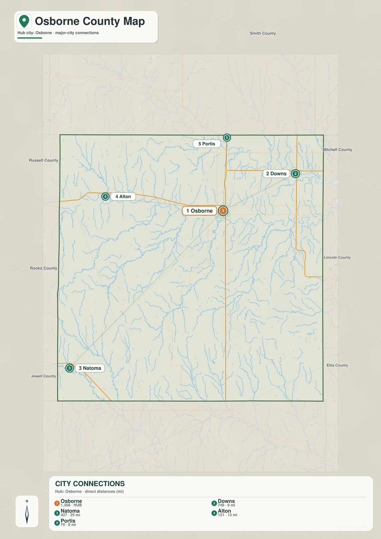
Kansas Tourism describes Downs as a community directly on US 24. Its Portis information notes that travelers cross the North Fork Solomon River before reaching town, while Alton is described as lying in the South Solomon River Valley. Those local descriptions match the separation visible between the road and water corridors on the maps.
The South Fork Solomon River cuts the county’s broad central valley
The strongest water feature across central Osborne County is the South Fork Solomon River. It enters from the west, passes the Alton area, and continues eastward through a broad meandering valley. Medicine Creek and Kill Creek descend from the southwest, while East Kill Creek and Covert Creek add more tributary valleys farther east.
Alton provides a particularly useful local reference. Kansas Tourism describes the town as being flanked by a meandering river and limestone bluffs in the South Solomon River Valley. The supplied water and elevation maps show the same setting: a low river corridor with higher ground rising nearby.
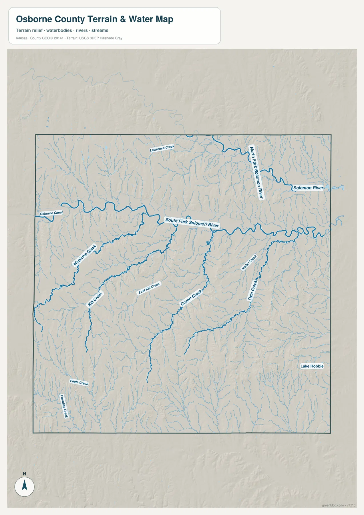
The North Fork Solomon River forms a separate low corridor in the northeastern county around Portis. Kansas Tourism’s Portis page specifically notes the river crossing on the approach to town from US 281. That valley is distinct from the South Fork, with uplands and many small tributaries between the two.
Indian Creek and Twin Creek cut the eastern and southeastern terrain, while Eagle Creek and Paradise Creek mark parts of the southwest. Lake Hobbie appears in the southeastern area as a smaller water body. These features make the county’s drainage much more varied than a simple two-river description would suggest.
This water image is for geographic reference, not flood-zone, navigation, water-quality, parcel, or legal-access decisions. Stream depth and flow can change, and mapped water features do not by themselves establish current recreation or safety conditions.
Relief from 444 to 637 meters rises sharply toward the west and southwest
The elevation map spans roughly 444 to 637 meters, with a mean near 532 meters. The highest brown and orange terrain is concentrated in the west and southwest, while the South Fork Solomon River forms a long green lowland across the middle. Lower terrain becomes more extensive toward the eastern side of the county.
The North Fork Solomon River creates another green corridor in the northeast, but it remains separate from the central South Fork valley. Higher ridges occupy the land between them, and smaller creeks cut narrow low strips through those uplands. The result is a landscape divided into several blocks of higher ground rather than one smooth slope.
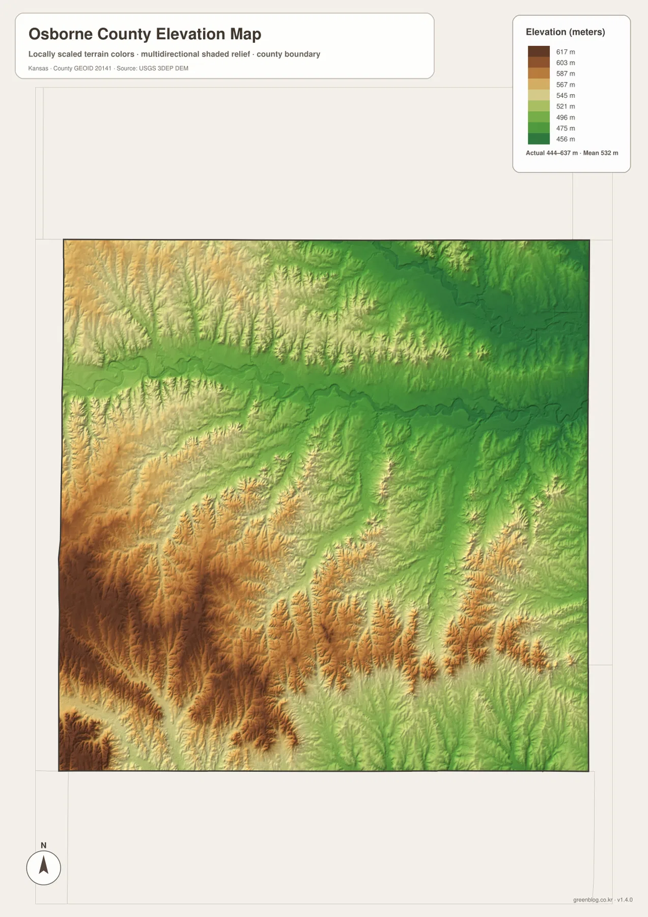
The Natoma side is one of the clearest places to see the higher southwestern terrain. Eagle Creek and Paradise Creek cut into those uplands before drainage moves toward the larger river systems. By contrast, the eastern county contains broader connected low areas around the river and tributary network.
The elevation surface is generalized for county-scale comparison. It is not survey-grade or engineering-grade measurement and should not be used for parcel elevations, construction grades, drainage design, or legal boundary work.
Alton shows how the South Solomon Valley meets limestone bluffs
Alton lies west of Osborne along the US 24 corridor and is closely tied to the South Fork Solomon River landscape. Kansas Tourism describes the town as being bordered by the meandering river and limestone bluffs, a setting that is easy to recognize when the water and elevation images are compared.
The river valley stays relatively low around Alton, while higher ground rises nearby to the south and west. That sharp contrast makes the town a useful reference for understanding why western Osborne County contains more pronounced relief than the broad lower terrain farther east.
Portis and Downs reveal two different features of the northeastern county
Portis is reached from the Osborne area along US 281 and sits near the North Fork Solomon River. KDOT project information also identifies a bridge over the North Fork Solomon River on the US 281 corridor between the north US 24 junction and Portis, confirming how closely the highway and river valley meet.
Downs is farther east and functions more as a highway junction, where US 24, K-9, and K-181 come together. The nearby terrain is crossed by many tributaries feeding the larger Solomon system. Although Portis and Downs are both close to Osborne, one is defined more strongly by the river crossing and the other by the road network.
Following US 24 from Alton through Osborne toward Downs shows the terrain change
A useful way to compare the county is to follow US 24 from west to east. Near Alton, the road is close to the South Fork Solomon River valley and higher western ridges. Around Osborne, road and river references converge near the county center. Toward Downs, the terrain becomes lower overall and the tributary network grows denser.
Natoma offers a contrasting view of the higher southwest, while Portis is the best reference for the separate North Fork Solomon River valley. Following one corridor at a time makes the relationship between roads, streams, and elevation easier to understand than memorizing a list of map categories.
For posters, classroom prints, or presentation slides, use the original JPG files in the download archive rather than enlarging the web previews. Small road labels, creek names, town text, and the elevation legend remain clearer at the higher resolution.
Frequently Asked Questions
Which listed town is closest to Osborne on the city-connections map?
Portis is shown about 8 direct miles from Osborne, with Downs about 9 miles away. Alton is about 13 direct miles and Natoma about 25. These are straight-line distances rather than driving distances.
Do the South Fork and North Fork Solomon rivers share the same valley in Osborne County?
No. The South Fork Solomon River crosses the central part of the county, while the North Fork Solomon River occupies a separate northeastern valley around Portis. Higher uplands and tributary creeks lie between them.
Can the 444–637 meter elevation image be used for surveying?
No. It is a generalized county-scale terrain image for comparing higher uplands with lower river valleys. Parcel elevations, engineering grades, drainage design, and legal boundary work require more precise official data and, where needed, professional surveying.
Map File Information
The archive contains the Osborne County, Kansas general county map, city-connections map, terrain-and-water map, and elevation map as original high-resolution JPG files.
- Included Files: Use only the versions confirmed in the article and supplied images
- File Type: Use the confirmed download contents
- Intended Use: Printing, education, presentations, and map-based projects
Related Maps
Sources and references
- Osborne County, Kansas official website — county government and local information
- Osborne County: Maps — official county road overview including US 24, US 281, and K-181
- Kansas Tourism: Alton — Alton and the South Solomon River Valley
- Kansas Tourism: Portis — Portis and the North Fork Solomon River crossing
- U.S. Census Bureau TIGER/Line Shapefiles — county boundary and geographic reference data
- USGS 3D Elevation Program — elevation and terrain reference data
Green Map creates custom-edited map images using open geographic data sources such as geoBoundaries, Natural Earth, OpenStreetMap, and government open data.
These maps are edited visual materials, not raw data files, and are provided for education, documents, presentations, and graphic reference.