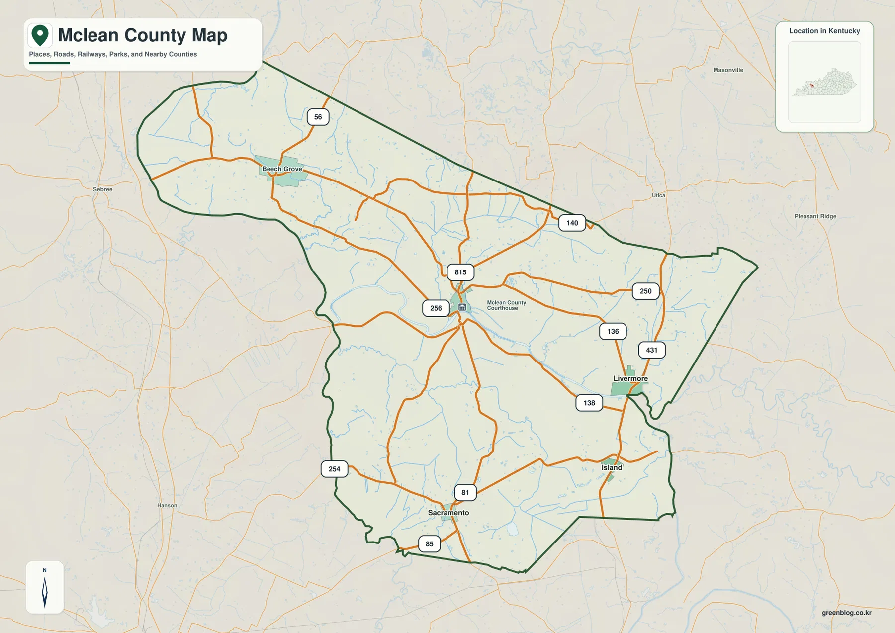
McLean County stretches across western Kentucky with the Green River running through the middle of the county and tying together Calhoun, Livermore, Island, and Sacramento. The general map shows routes 56, 140, 250, 431, 136, 81, and 85, while the physical maps reveal the Green River, Rough River, Pond River, and a dense network of tributary creeks. Elevation changes from broad low ground along the central river corridor to more broken ridges in the north and east. The original high-resolution JPG versions of the maps can also be downloaded together in one ZIP archive for printing, classroom work, presentations, or offline reference. High-resolution map files are available for download in the section below.
Calhoun is a strong central reference because the McLean County Courthouse marker and several roads converge there. Livermore lies farther east near the Green River and Rough River side, Island sits south of Livermore, and Sacramento anchors the south-central part of the county. Beech Grove provides a northwestern landmark. Kentucky’s official McLean County profile lists the county government address on Main Street in Calhoun and notes that the county was formed in 1854 from portions of Daviess, Ohio, and Muhlenberg counties.
Table of Contents
Calhoun provides the central road reference for the county
The general county map makes Calhoun the easiest place to begin. Routes 815 and 256 meet near the courthouse marker, while routes 250 and 136 continue toward the Livermore side. Route 81 reaches south toward Sacramento, and roads toward the northwest connect Calhoun with Beech Grove and route 56. Because several directions branch from this central area, locating Calhoun first makes the rest of the road network much easier to follow.
Livermore is served by route 431 running north-south and by routes 136 and 138 crossing the eastern part of the county. Island lies just south of Livermore, while Sacramento is farther southwest near routes 81 and 85. Roads in this part of McLean County often bend around Green River lowlands and smaller creek valleys rather than forming a straight grid.
Beech Grove appears in the northwestern section near route 56 and helps define the county’s long northern extension. Outside the boundary, Sebree, Hanson, and Utica provide additional orientation. The county narrows through the middle before widening again to the south, so using Beech Grove, Calhoun, Livermore, and Sacramento as separate reference points gives a clearer sense of its overall shape.
The map is intended for geographic orientation, not live navigation. Current construction, bridge conditions, road closures, and driving times should be checked with up-to-date transportation sources. In a county crossed by the Green River and many tributaries, actual road travel can be longer than the apparent direct separation between two locations.
Livermore links Calhoun, Island, and Sacramento on the city-connections map
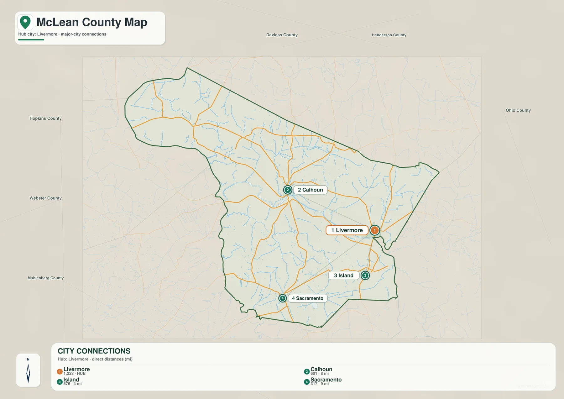
The city-connections map uses Livermore as the hub and lists direct distances to three other highlighted communities. Livermore is labeled with 1,223 residents, Calhoun with 601, Island with 576, and Sacramento with 317. The map shows about 8 miles from Livermore to Calhoun, 4 miles to Island, and 9 miles to Sacramento. These are straight-line distances between the mapped points rather than road-driving distances.
Calhoun lies west of Livermore across the Green River side, Island is directly south, and Sacramento sits farther southwest. The three destinations therefore describe different parts of the central and southern county rather than one single urban cluster. Green River crossings and winding rural roads can make actual travel more complicated than the direct lines on the simplified city map suggest.
Island is the closest highlighted community to Livermore on the map, at about four straight-line miles. Sacramento is farther away in the southern interior, while Calhoun is a central administrative and road reference on the opposite side of the river corridor. Those contrasts make the city map useful for orientation even though it deliberately omits the smaller roads and creeks that affect real travel.
The simplified city view works well in classroom or presentation settings when the main goal is direction and relative spacing. The general county map is better for route numbers, Beech Grove, courthouse context, and smaller local connections. Moving from the city map to the water and elevation views also shows why those towns occupy slightly different terrain settings.
Green River and Rough River organize the county’s broad central lowland
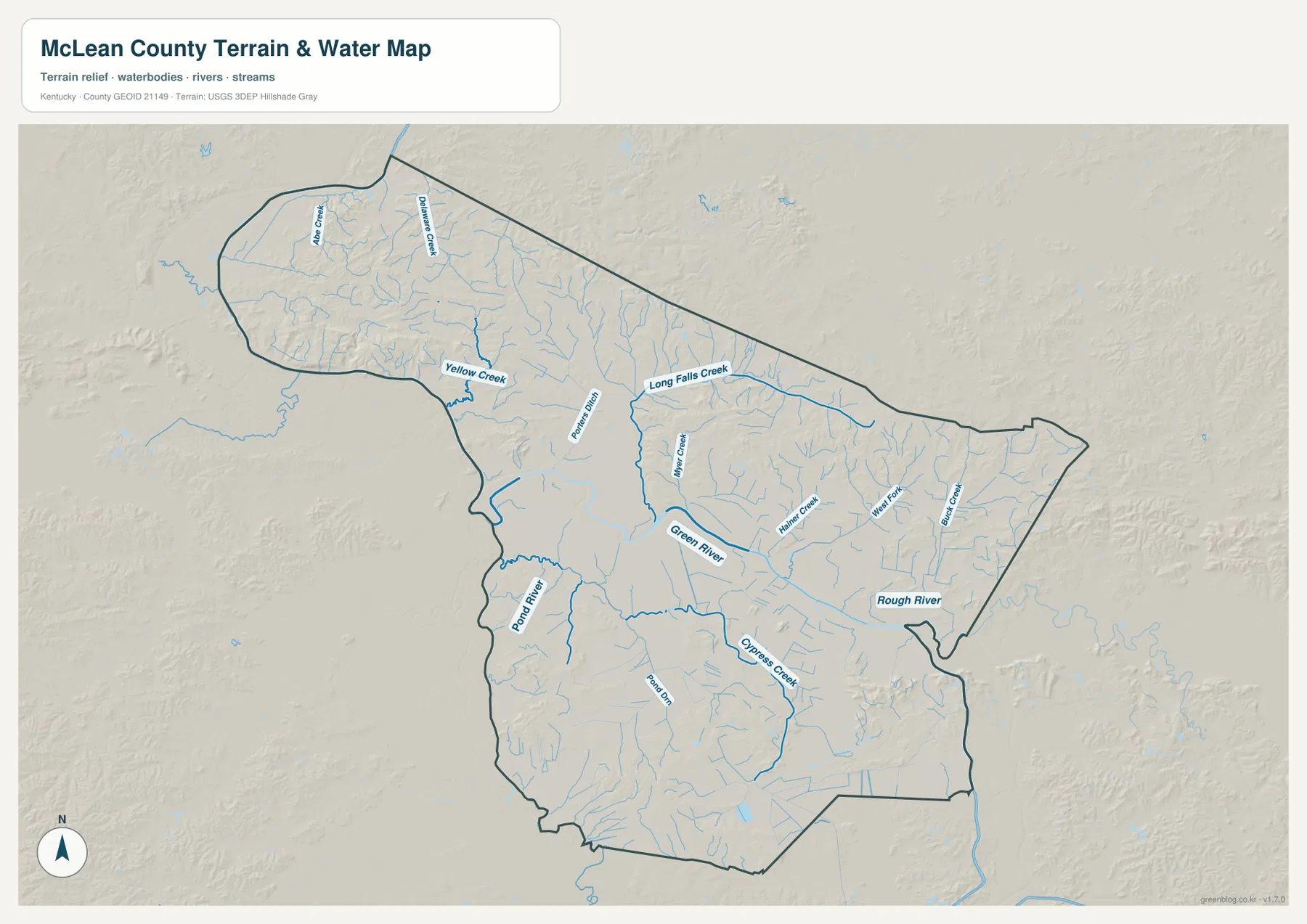
The terrain-and-water map is dominated by the Green River, which crosses the middle of McLean County from west toward the Livermore side. Rough River approaches from the east, while Pond River forms another major water reference in the west and southwest. The broad low ground around these rivers separates the more heavily dissected hills in the north from the rolling southern interior.
Drakes Creek and Yellow Creek provide recognizable water references in the northwest. Long Falls Creek extends through the north-central part of the county, while Panther Ditch and Bitter Creek occupy smaller valleys closer to the Green River corridor. Their directions show how water from the northern ridges drains toward the lower central river system.
Cypress Creek is one of the strongest named streams in the southern half, and the eastern side includes West Fork and Black Creek near the Rough River country. Numerous unnamed tributaries fill the spaces between those labels. The shaded relief makes the relationship straightforward: the streams use lower valleys, while narrow ridges remain between them.
A useful way to read the map is to find the Green River first, then add Pond River to the west, Rough River to the east, Long Falls Creek in the north, and Cypress Creek in the south. This is a general geographic map rather than a flood, navigation, water-depth, fishing-regulation, or property-access product. Current conditions should come from the agencies responsible for those waterways.
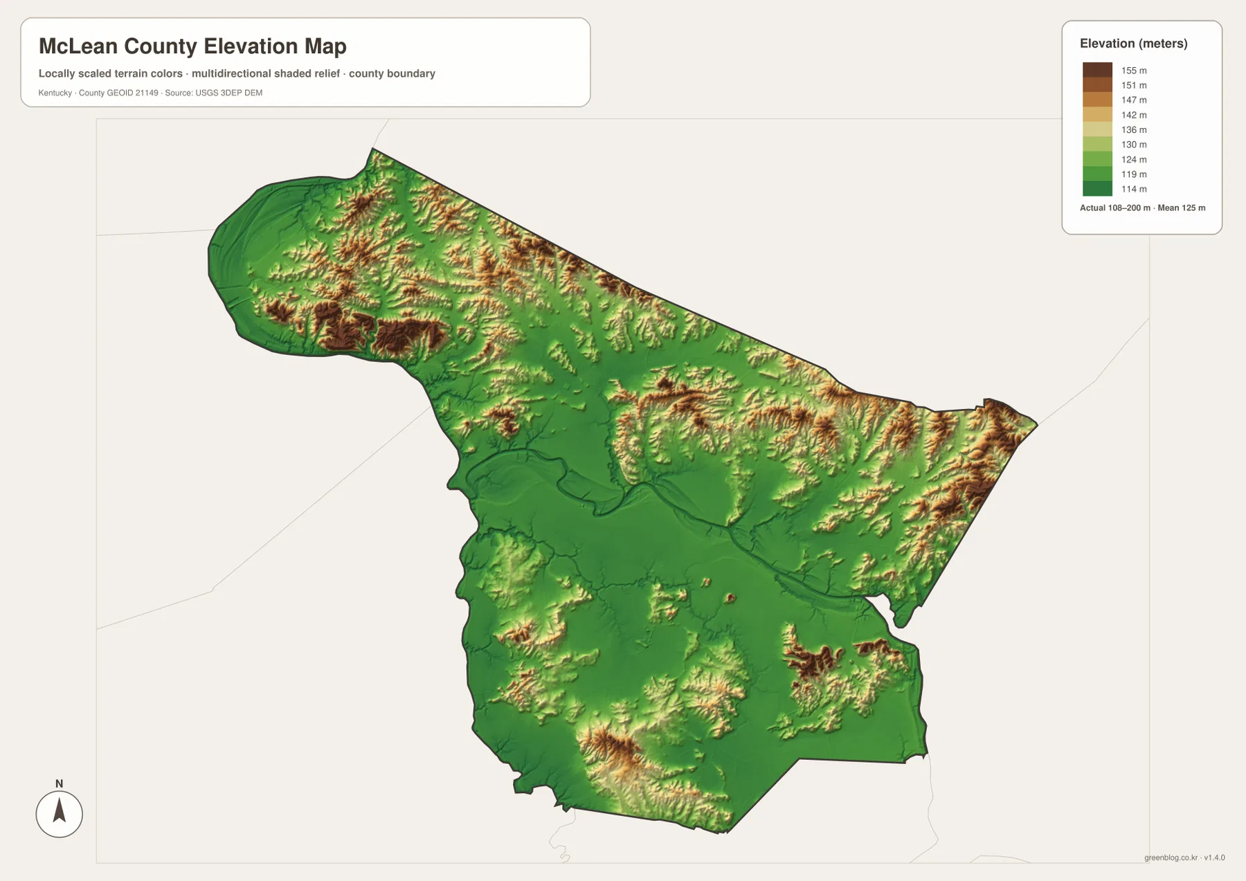
Elevation from 108 to 200 meters highlights the river corridor and surrounding ridges
The elevation map reports an actual county range of about 108 to 200 meters and a mean near 125 meters. The lowest green terrain follows the Green River corridor across the center and extends into broad low areas toward the west and south. Lower colors also trace the Rough River and major creek valleys. Higher orange and brown ridges are much more common in the northern and northwestern sections, with additional uplands along the eastern edge.
The Beech Grove side has some of the strongest ridge relief. Drakes Creek and Yellow Creek cut lower corridors through that higher ground, and roads follow the same broken terrain. The north-central area around Long Falls Creek also contains repeated ridges rather than one continuous flat surface.
Calhoun and Livermore occupy the broad central lowland associated with the Green River. The elevation map shows a connected green corridor between and around those areas, while terrain rises again to the north and in parts of the east. Island and Sacramento sit within generally lower southern terrain, although smaller ridges interrupt the lowland in several places.
The colors are intended for county-scale comparison rather than precise site measurement. They are useful for distinguishing river lowlands, creek valleys, and higher ridges, but they do not provide survey-grade elevation for a parcel, road, structure, or engineering project. Exact site work should use current source elevation data or professional surveying.
A practical route through the maps from Calhoun to Livermore and the southern towns
Calhoun is the easiest starting point for moving between the map views. On the county map, locate the courthouse marker with routes 815 and 256, then follow routes 250 and 136 toward Livermore. On the water map, the Green River explains the broad low corridor between the two areas. The elevation map then confirms that this central part of the county is lower than many of the ridges to the north.
From Livermore, the city-connections map places Island to the south and Sacramento to the southwest. The county map adds routes 431, 138, 81, and 85, while the physical map brings in Rough River and Cypress Creek. Reading those features together provides a much better picture than treating the communities as isolated points.
The Beech Grove area offers a useful contrast. Route 56 provides the road reference, Drakes Creek and Yellow Creek organize the water network, and the elevation map shows much stronger ridge relief than the Green River corridor. Following one place through several maps makes the county’s internal differences easy to see without relying on technical GIS language.
Choosing the most useful McLean County map for print, class, or reference
Use the general county map when Calhoun, Livermore, Island, Sacramento, Beech Grove, numbered roads, and the full boundary need to appear together. The city-connections map is cleaner when the question is simply how Calhoun, Island, and Sacramento relate to Livermore and what their straight-line distances are.
Choose the terrain-and-water map for the Green River, Rough River, Pond River, Long Falls Creek, Cypress Creek, and smaller tributaries. The elevation map is the strongest view for explaining the difference between the low central river corridor and the more pronounced ridges in the north and east. Displaying the water and elevation maps together makes that relationship especially clear.
The WebP images in the article are optimized for browser viewing. The downloadable ZIP contains the original JPG maps at 3,638×2,572 pixels each, which is better suited to printing, classroom worksheets, presentations, and offline reference. These maps are general geographic resources rather than legal boundary records, flood studies, navigation charts, parcel surveys, or engineering plans.
Frequently Asked Questions
Are the distances from Livermore to Calhoun, Island, and Sacramento driving distances?
No. The city-connections map shows straight-line distances of about 8 miles to Calhoun, 4 miles to Island, and 9 miles to Sacramento. Actual driving distances can be longer because road routes depend on Green River crossings, local road geometry, and the surrounding creek valleys.
Which map best shows the Green River and Rough River together?
The terrain-and-water map is the best choice. It shows the Green River across the center of the county, Rough River on the eastern side, Pond River to the west and southwest, and named tributaries such as Long Falls Creek, Cypress Creek, and Yellow Creek.
Can the 108–200 meter elevation range be used as an exact property elevation?
No. That range summarizes the actual countywide elevations shown on the map, with a mean near 125 meters. It is useful for comparing the low Green River corridor with the higher northern and eastern ridges, but exact site elevations should come from current source data or professional surveying.
Map File Information
The ZIP archive contains the original high-resolution JPG versions of the McLean County road-and-boundary map, city-connections map, terrain-and-water map, and elevation map. Each image is 3,638×2,572 pixels for printing, classroom work, presentations, and offline reference.
- File Type: 4 JPG files inside one ZIP archive
Related Maps
Sources and references
County information is available from the Kentucky.gov McLean County profile. For underlying geographic data, see the U.S. Census Bureau TIGER/Line Shapefiles for boundaries and roads, USGS National Hydrography for rivers and streams, and the USGS 3D Elevation Program for elevation data.
These maps are intended for geographic explanation, printing, and general reference. Legal boundary decisions, live traffic, flood and water-safety questions, property surveying, and engineering work should rely on the latest authoritative information from the responsible public agency.
Green Map creates custom-edited map images using open geographic data sources such as geoBoundaries, Natural Earth, OpenStreetMap, and government open data. These maps are edited visual materials, not raw data files, and are provided for education, documents, presentations, and graphic reference.