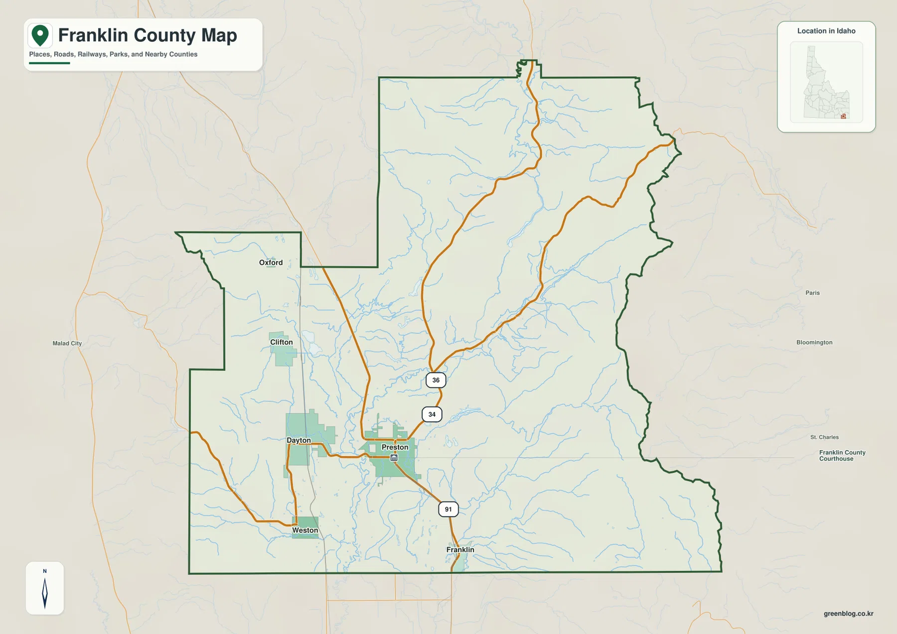
Download the Franklin County Idaho Map as one ZIP containing high-resolution A3 JPG versions of the county overview, city, terrain-and-water, and elevation maps. The WEBP previews below let you inspect Preston, Franklin, Weston, Dayton, Clifton, Oxford, the Bear River, Oneida Narrows Reservoir, major roads, and mountain relief before opening the larger files for printing, classroom work, reports, or presentations.
Franklin County occupies the southeastern corner of Idaho just north of the Utah line. Preston is the county seat and the largest community shown in the supplied city index, while Franklin, Weston, Dayton, Clifton, and Oxford are spread across the central and western valleys. The Bear River and a chain of reservoirs cross this lower country, and the terrain rises sharply toward the eastern boundary.
Table of Contents
Use Preston to orient the roads and county shape
The county overview makes Preston the easiest starting point. Franklin County’s official website identifies Preston as the county seat, and the map places it in the south-central valley where several roads and waterways come together. Franklin lies immediately to the south, while Dayton and Weston are west and southwest of Preston. Clifton and Oxford sit farther northwest in the county’s western extension.
US 91 provides a clear north-south reference between the Preston and Franklin area. Idaho 34 runs north from Preston before continuing toward the eastern side of the county, and Idaho 36 branches through the country north of Preston toward higher terrain. Smaller local roads connect the western towns and rural valleys, so the overview is useful for seeing how the central settlement area spreads into the surrounding countryside.
The county outline is irregular rather than rectangular. A western projection contains Oxford and Clifton, the broad northern half reaches into mountain drainages, and the eastern boundary bends along higher terrain near Bear Lake County. The southern edge lies close to Utah, making Preston and Franklin useful reference points for understanding the county’s north-south position.
The city map shows a Preston-centered valley with smaller western communities
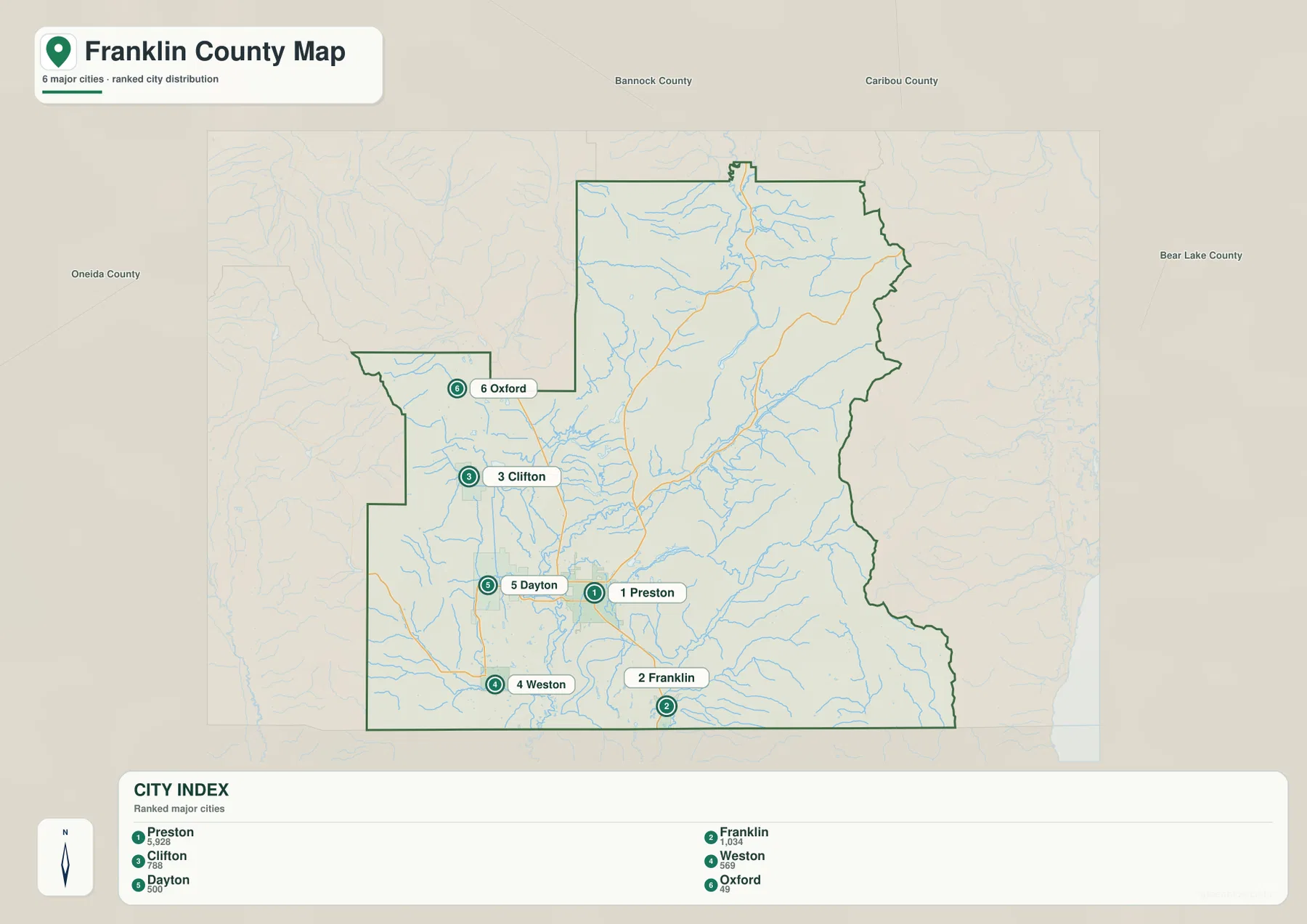
The city map highlights six communities: Preston, Franklin, Clifton, Weston, Dayton, and Oxford. In the supplied ranking, Preston is first and Franklin second, followed by Clifton, Weston, Dayton, and Oxford. The difference in rank makes Preston the obvious urban reference, but the map also shows that smaller communities extend well beyond the immediate Preston area.
Franklin is directly south of Preston, while Weston and Dayton sit to the west and southwest. Clifton is farther northwest, and Oxford is separated still farther north in the western arm of the county. This distribution makes the city view useful for understanding the broad valley settlement pattern before adding the detailed roads and waterways from the overview.
The city map does not display connector-distance labels, so it should not be used to estimate a specific straight-line or driving distance between the towns. Its strength is direction: after locating the six communities here, the county map can be used to add US 91, Idaho 34 and 36, county boundaries, and nearby drainage lines.
Bear River and Oneida Narrows Reservoir organize the water map
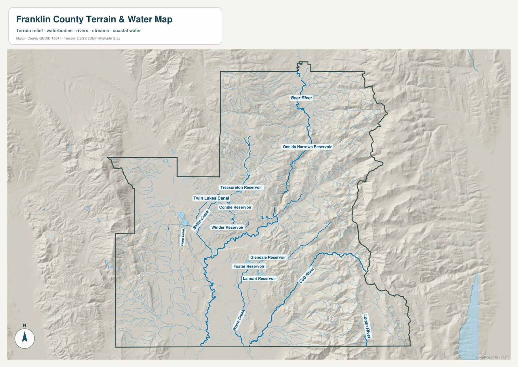
The Bear River is the dominant named waterway on the terrain-and-water map. It enters the northern part of Franklin County and follows the main valley southward through Oneida Narrows Reservoir. Idaho Fish and Game identifies Oneida Narrows Reservoir as a Bear River water in Franklin County, making it one of the county’s most useful geographic landmarks.
West of the main river are Treasureton Reservoir, Condie Reservoir, and Winder Reservoir, along with Twin Lakes Canal. Battle Creek and Deep Creek drain the western side toward the lower central country. This combination of reservoirs, canal, and smaller creeks gives the western valley a much denser water pattern than a simple river-only map would suggest.
Farther south and east, Cub River and Logan River form major tributary systems. Glendale Reservoir, Foster Reservoir, and Lamont Reservoir are labeled close together in the southern-central part of the county, and Mink Creek descends from the higher southern terrain. Franklin County’s official county profile also names Oneida Narrows and Cub River Canyon among its notable scenic places, matching the strong water-and-valley features visible on the map.
This is a geographic reference map for rivers, creeks, reservoirs, and canals. It is not a flood-hazard map, depth chart, navigation product, parcel map, or legal water-right document. Current operating rules, water levels, and access conditions should be checked with the appropriate official management agency.
The eastern mountains rise well above the central valley
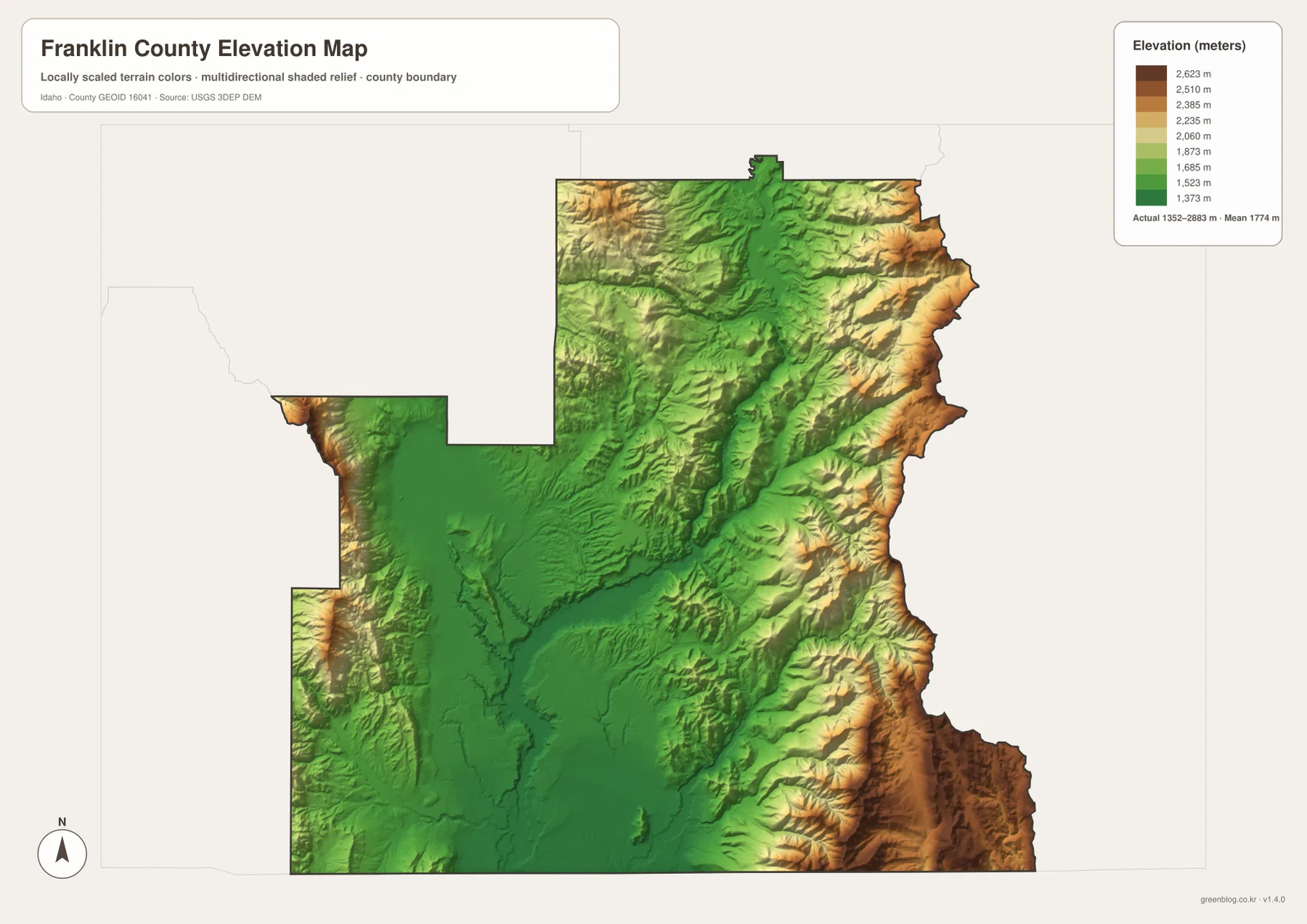
The elevation map shows a broad green lowland across much of the central and southwestern county. Preston, Franklin, Dayton, and Weston lie within or near this lower valley setting. Moving east, the colors become yellow and brown as the terrain climbs sharply along the county boundary, and smaller high ridges also appear on the western side.
The supplied elevation graphic reports an actual range of about 1,352 to 2,883 meters, with a mean near 1,774 meters. The highest terrain is concentrated along the eastern and southeastern mountain margins, while the Bear River corridor and central valley remain much lower. Stream valleys appear as green channels between higher ridges, closely matching the drainage pattern on the water map.
Franklin County’s official profile also notes visible shorelines left by ancient Lake Bonneville on the eastern benches. The elevation map is not a geologic-history map, but the strong step from valley floor to mountain bench and ridge gives helpful context for those landscape features. The colors are intended for county-scale comparison rather than property surveying or engineering measurement.
Combine the maps to connect towns, roads, water, and relief
For ordinary orientation, start with the city map to locate Preston, Franklin, Weston, Dayton, Clifton, and Oxford, then move to the county overview to add US 91 and Idaho 34 and 36. This sequence makes the settlement pattern easy to understand before the more detailed terrain and water information is introduced.
The terrain-and-water map is the next step when the Bear River, Oneida Narrows Reservoir, Cub River, or the southern reservoirs are the main interest. After locating those features, the elevation map explains why the eastern streams descend from much higher ground and why the largest communities occupy the broad lower valley.
This combination works well for classrooms, local research, trip planning, reports, and presentations. A reader can trace Preston from the city map to the road network, compare its relationship to the Bear River system, and then use the elevation map to see how strongly the valley differs from the eastern mountain wall.
Frequently Asked Questions
Where is Preston on the Franklin County map?
Preston is in the south-central valley near US 91 and Idaho 34 and 36. It is the county seat and the largest city in the supplied city index, making it the easiest reference point for locating Franklin, Weston, Dayton, Clifton, and Oxford.
Which map is best for finding Oneida Narrows Reservoir?
The terrain-and-water map is the clearest view. Oneida Narrows Reservoir appears on the Bear River in the northern-central part of the county and can be compared with Treasureton, Condie, Winder, Glendale, Foster, and Lamont reservoirs.
Which part of Franklin County is highest?
The eastern and southeastern mountain margins are the highest areas on the supplied elevation map, with some additional high ground along the west. The map reports an overall elevation range of roughly 1,352 to 2,883 meters.
Map File Information
The ZIP contains high-resolution A3 JPG versions of the Franklin County overview, city, terrain-and-water, and elevation maps.
- File Type: JPG files inside one ZIP archive
Related Maps
Sources and references
- Franklin County official website — About Franklin County
- Idaho Fish and Game — Oneida Narrows Reservoir
- U.S. Census Bureau TIGER/Line Shapefiles
- USGS National Hydrography
- USGS 3D Elevation Program
Green Map creates custom-edited map images using open geographic data sources such as geoBoundaries, Natural Earth, OpenStreetMap, and government open data.
These maps are edited visual materials, not raw data files, and are provided for education, documents, presentations, and graphic reference.