Download the Fremont County Idaho Map as one ZIP containing high-resolution A3 JPG versions of the county overview, city, terrain-and-water, and elevation maps. The WEBP previews below let you inspect St. Anthony, Ashton, Island Park, major roads, Henrys Lake, Henrys Fork, Warm River, Falls River, and the county’s large elevation change before opening the bigger files for printing, classroom work, reports, or presentations.
Fremont County stretches from the lower settlement belt around St. Anthony and Teton northward through Ashton and Island Park to Henrys Lake and the mountain rim near the top of eastern Idaho. The Idaho Blue Book records that the county was established on March 4, 1893, with St. Anthony as the county seat. That south-to-north transition is easy to see on the maps: cities and major roads are concentrated in the south, while waterways and high terrain become increasingly dominant toward Island Park and the northern and eastern boundaries.
Table of Contents
St. Anthony provides the clearest anchor for the long north–south county
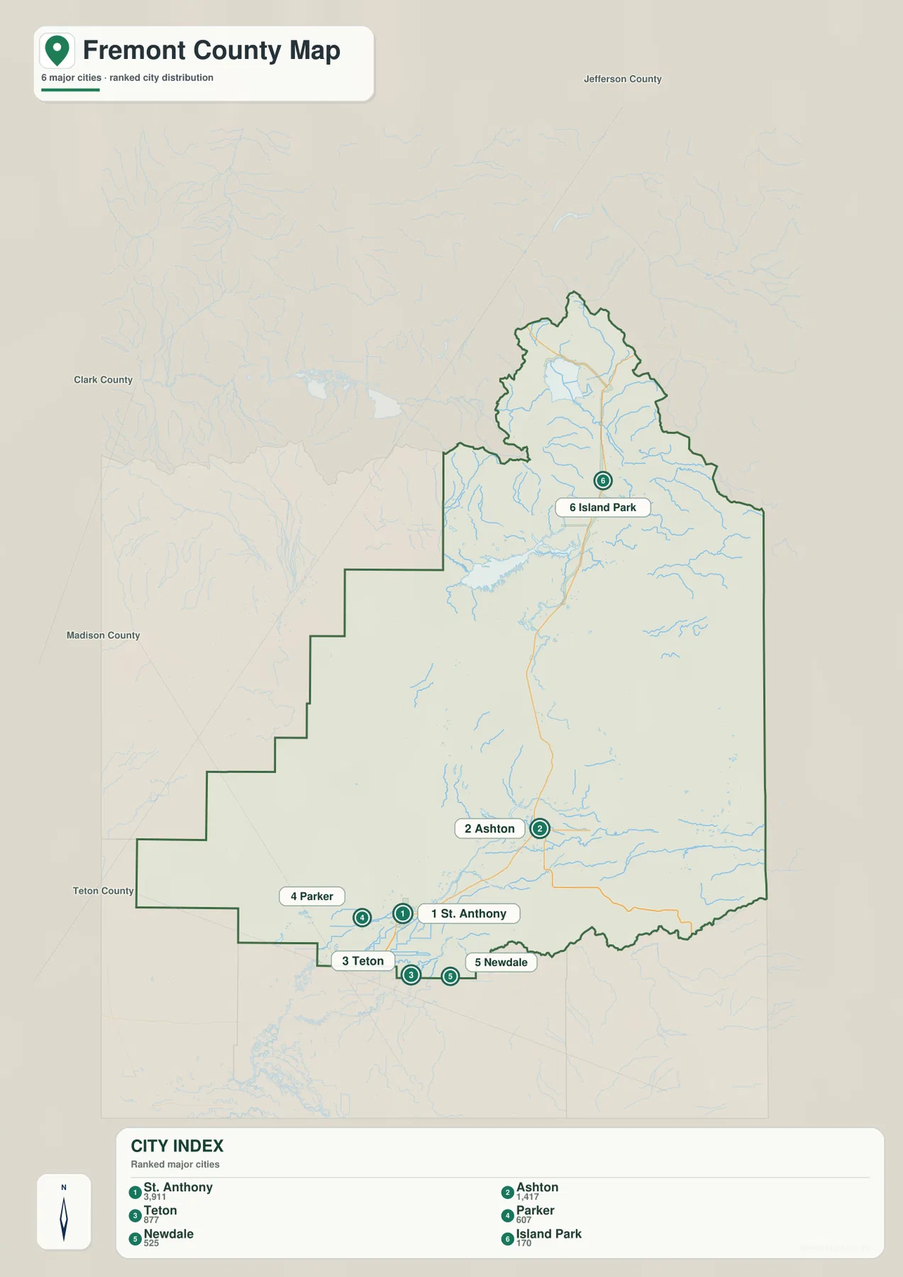
The county overview places St. Anthony near the southern edge, where roads and streams are easier to follow than in the mountain country farther north. Teton, Parker, and Newdale form a small cluster in the same southern lowlands. Ashton is farther north along the main highway corridor, while Island Park occupies a much more remote position in the northern half of the county.
US 20 is the strongest road reference on the map. It runs north from the St. Anthony area through Ashton and continues toward Island Park. Near the top of the county, Idaho 87 branches toward Henrys Lake. Idaho 47 appears around Warm River, Idaho 33 serves the southern Teton area, and Idaho 32 follows the southeastern side of the county.
The boundary reinforces the same geographic contrast. Long stair-step sections define much of the west and southwest, while the northern tip narrows and then broadens around Henrys Lake. The eastern edge follows high terrain for a long distance. Even on the general map, blue tributaries become much more numerous toward the north and east, previewing the complex water network shown in the terrain-and-water view.
The city map shows a southern cluster and a much more distant Island Park
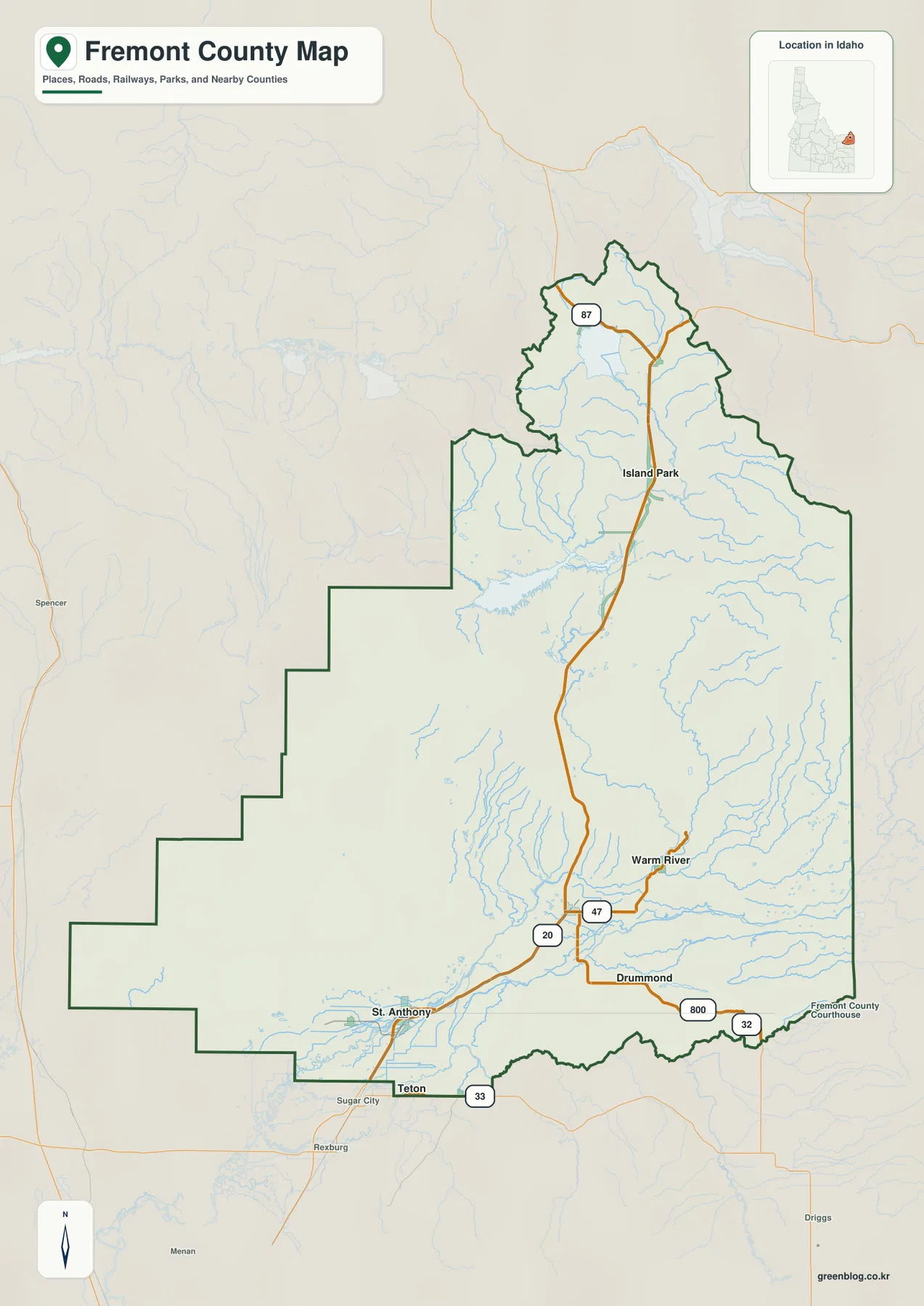
The city map highlights St. Anthony, Ashton, Teton, Parker, Newdale, and Island Park. In the supplied city index, St. Anthony ranks first and Ashton second, followed by Teton, Parker, Newdale, and Island Park. The ranking is less important than the pattern: most of the marked communities sit in the southern part of the county or along the US 20 corridor.
St. Anthony, Teton, Parker, and Newdale are grouped close together near the southern edge. Ashton forms the next step north, and Island Park is separated much farther up the county. That arrangement makes the city map useful for understanding settlement concentration before adding the complicated drainage and mountain terrain seen on the other maps.
The city graphic does not include connector-distance labels, so it should not be used to infer exact straight-line or driving distances. Its strength is direction. Once the six places are familiar, the county overview can be used to add US 20, Idaho 33, Idaho 87, and the smaller road connections that link the settlements.
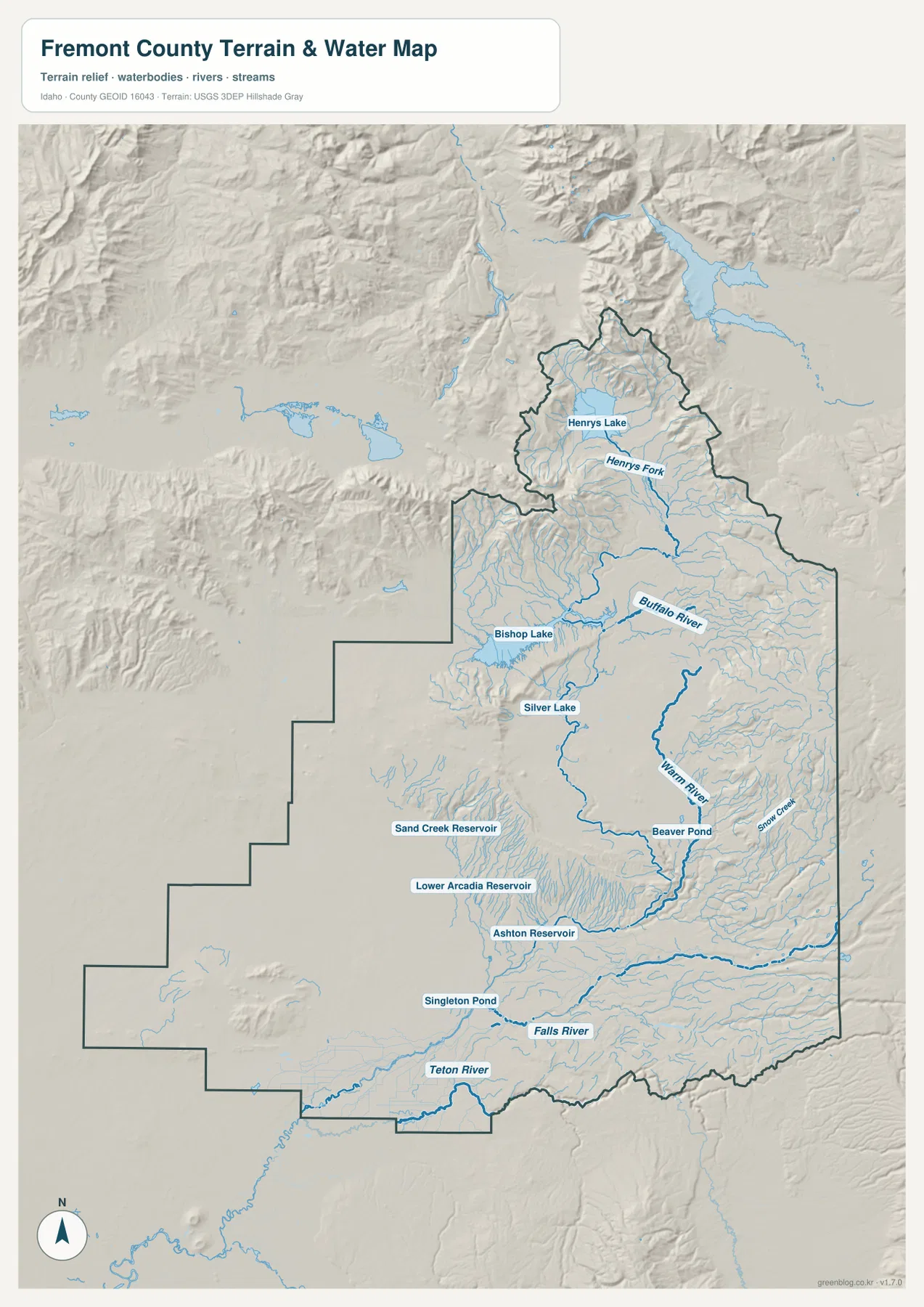
Henrys Lake, Henrys Fork, Warm River, and Falls River shape the water map
Henrys Lake is the most prominent water body at the northern end of the terrain-and-water map. Idaho Fish and Game identifies Henrys Lake as a Fremont County lake near Island Park. From the lake area, Henrys Fork becomes the key downstream reference, passing through the broad northern interior and connecting the high lake basin with the rest of the county.
Buffalo River is labeled across the central-northern part of the county, and Warm River becomes a stronger drainage farther south. Beaver Pond lies near the Warm River corridor, while Snow Creek descends from the eastern mountain side. Bishop Lake and Silver Lake provide smaller water landmarks west of the main river corridor.
In the south, the water system changes again. Ashton Reservoir, Lower Arcadia Reservoir, Sand Creek Reservoir, and Singleton Pond are labeled across the lower half, while Falls River and Teton River cross the southern part of the county. Taken together, the map shows several distinct drainage areas rather than one simple river line from north to south. It is a geographic reference for rivers, streams, lakes, and reservoirs, not a flood-hazard map, depth chart, navigation product, parcel map, or legal water-right document.
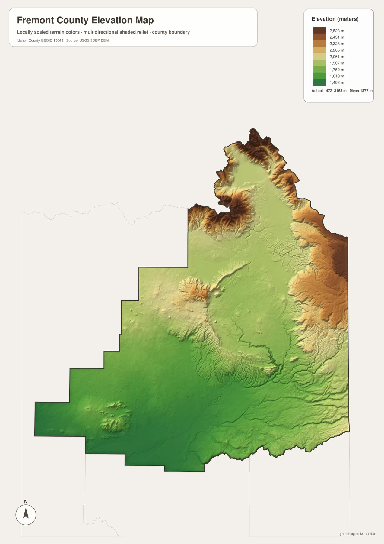
Elevation rises from the southern agricultural lowlands into the northern and eastern mountains
The elevation map shows the St. Anthony and Teton side of the county in darker green, marking the broad lower terrain of the south and southwest. Moving north, colors shift through lighter green and yellow. The mountain rim around Henrys Lake and the long eastern boundary rises into extensive tan and brown high country.
The supplied elevation graphic reports an actual range of about 1,472 to 3,168 meters, with a mean near 1,877 meters. The highest ridges are concentrated near the far north and along much of the eastern edge. Island Park and the Henrys Fork corridor sit in a broad higher basin and plateau that remains lower than the surrounding mountain walls.
Comparing this map with the water view explains many of the stream patterns. Henrys Fork, Warm River, and Falls River descend through lower corridors between high terrain, and the main roads also tend to follow the gentler parts of the county. The colors are intended for county-scale comparison rather than property-level surveying or engineering design.
Reading the county from its southern towns to the Island Park high country
For ordinary orientation, begin with the city map to locate St. Anthony, Teton, Parker, Newdale, Ashton, and Island Park. Then move to the county overview and follow US 20 north. This sequence makes the large distance between the southern settlement cluster and the Island Park area much easier to understand.
The terrain-and-water map is the next step when Henrys Lake, Henrys Fork, Warm River, or Falls River is the main interest. After those waterways are located, the elevation map explains why the northern and eastern edges are so rugged and why the main road and river corridors occupy comparatively gentler ground.
This combination works well for classrooms, local research, trip planning, reports, and presentations. A reader can trace St. Anthony from the city map to US 20 on the overview, follow the route north toward Ashton and Island Park, compare Henrys Lake and Henrys Fork on the water map, and then use the elevation map to see the transition from southern lowlands to northern high country.
Frequently Asked Questions
How are St. Anthony and Island Park positioned on the map?
St. Anthony is in the southern settlement area, while Island Park is far to the north in the higher plateau and mountain region. On the county overview, US 20 provides the clearest road reference between the St. Anthony–Ashton corridor and Island Park.
Which map is best for finding Henrys Lake and Henrys Fork?
The terrain-and-water map is the clearest view. Henrys Lake appears at the northern end of the county, and Henrys Fork continues through the Island Park area below it. Buffalo River, Warm River, and smaller lakes can be compared on the same map.
Which parts of Fremont County are highest?
The far northern mountains around the Henrys Lake basin and much of the eastern mountain boundary are the highest areas. The supplied elevation map reports an overall range of roughly 1,472 to 3,168 meters, while the St. Anthony and Teton area is much lower.
Map File Information
The ZIP contains high-resolution A3 JPG versions of the Fremont County overview, city, terrain-and-water, and elevation maps.
- File Type: JPG files inside one ZIP archive
Related Maps
Sources and references
- Fremont County official website
- Idaho Secretary of State — Idaho Blue Book, Fremont County
- Idaho Fish and Game — Henrys Lake
- U.S. Census Bureau TIGER/Line Shapefiles
- USGS National Hydrography
- USGS 3D Elevation Program
Green Map creates custom-edited map images using open geographic data sources such as geoBoundaries, Natural Earth, OpenStreetMap, and government open data.
These maps are edited visual materials, not raw data files, and are provided for education, documents, presentations, and graphic reference.