Apache County occupies a striking north-south strip along the eastern side of Arizona. A single county boundary contains communities that are separated by long distances, from Red Mesa and Dennehotso in the far north through the Chinle area to St. Johns, Springerville, and Eagar in the south. The Apache County Map on this page is designed to make that unusual shape easier to understand by separating four useful questions: where the main roads and places are, how the principal cities are positioned, where named rivers and lakes appear, and how elevation changes from one end of the county to the other.
The page includes a county reference map, a city-index map, a terrain-and-water map, and an elevation map. The web versions are useful for quick viewing, while the download box farther down the page provides the matching high-resolution JPG files in one ZIP. Instead of treating the four maps as interchangeable, it helps to start with the question you are trying to answer. Someone looking for Chinle or US 191 will get the clearest answer from the county map, while a reader comparing the southern high country with the broad central plateau will learn more from the elevation map.
Apache County government describes the county as an exceptionally long part of northeastern Arizona, extending from the Utah state line toward the White Mountains. County planning material also identifies the White Mountains in the south as the highest part of the county and notes the importance of the Little Colorado River watershed. Those broad facts are visible in the supplied maps: the county remains narrow for much of its length, the south contains the strongest elevation colors, and named lakes and streams become much more concentrated near the southern mountains.
Table of Contents
A long county where distance matters as much as direction
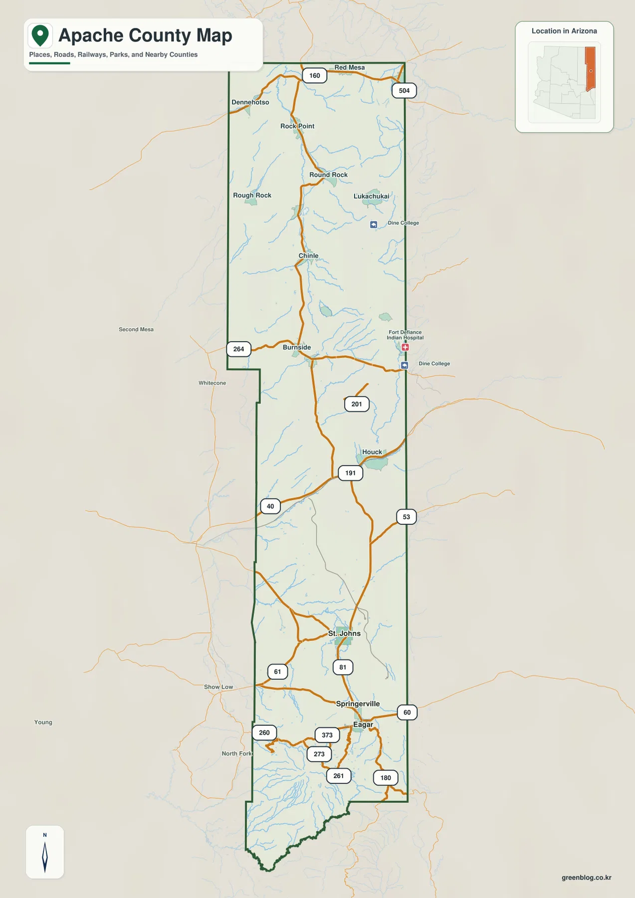
The county reference map makes Apache County look almost like a vertical corridor. Red Mesa sits near the northern edge, with Dennehotso, Rock Point, Round Rock, Rough Rock, Lukachukai, and Chinle appearing farther south. The middle portion includes Burnside and Houck, while St. Johns, Springerville, and Eagar are clustered much closer to the southern end. Seeing all of these places inside one outline is useful because it prevents a common mistake: assuming that communities in the same county are necessarily close to one another.
The surrounding context also matters. Apache County follows Arizona’s eastern side, so many roads approach or cross the New Mexico side of the map, while Navajo County lies to the west. The reference map leaves enough outside detail visible to show that the county is connected to a wider regional road network rather than isolated inside its boundary. That is especially helpful around the northern and central segments, where travelers may enter the county from several directions before joining a north-south route.
The county’s elongated shape also explains why a single “center” does not describe it very well. Chinle is a major reference point in the north-central portion, St. Johns is the county seat much farther south, and the Round Valley communities of Springerville and Eagar form another distinct cluster near the southern mountains. The National Park Service places Canyon de Chelly National Monument on the outskirts of Chinle, giving the Chinle label added geographic importance even though the monument itself is not drawn as a separate feature on this map.
US 191 provides the clearest north-south reference
US 191 is the road that most clearly helps a reader organize the county from north to south. It passes through the Chinle area and continues down the county toward St. Johns and the Springerville-Eagar area. Because Apache County is so long, using US 191 as a reference makes it easier to judge whether a place is in the northern Navajo Nation portion, near the I-40 corridor, or in the southern high country. The map is not a turn-by-turn navigation product, but it is well suited to this kind of regional orientation.
Several east-west routes divide that long north-south strip into recognizable sections. US 160 crosses the far north near Red Mesa and Dennehotso. Route 264 appears farther south near Burnside and the Chinle region. I-40 crosses the county in the middle-to-southern portion near Houck, creating another obvious reference line. In the south, US 60 and other state and U.S. routes converge around St. Johns, Springerville, and Eagar. These crossings make the county much easier to read than the outline alone would suggest.
The road pattern also changes from one end of the county to the other. Northern routes connect a series of widely spaced communities, and the map leaves large areas between labels. Around St. Johns and especially Springerville and Eagar, more numbered roads come together in a smaller area. That contrast is useful when planning a classroom map, a travel overview, or a report figure because it explains why the southern portion looks visually busier even though the county boundary itself remains narrow.
The city index highlights a compact southern cluster
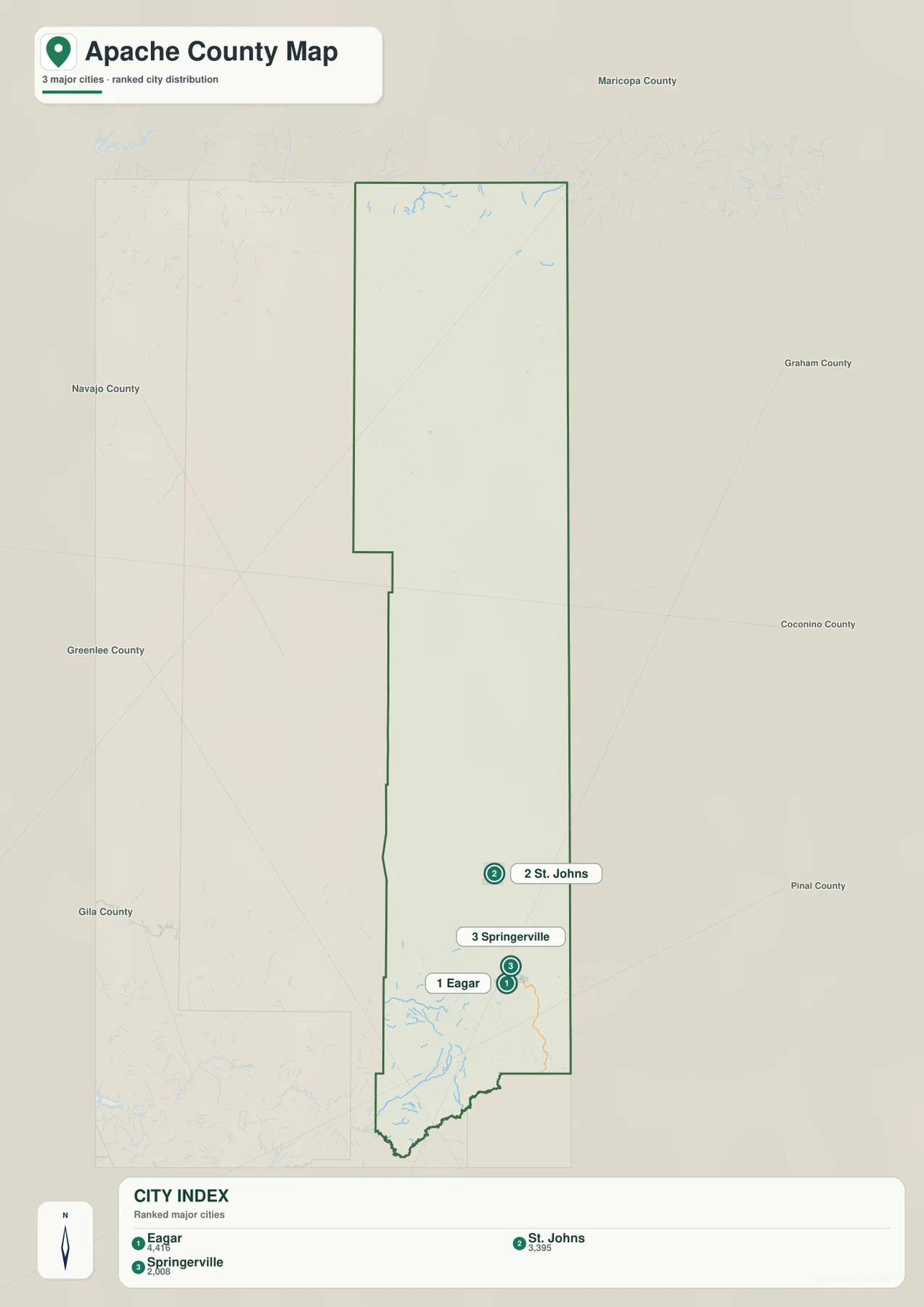
The city map has a different purpose from the county reference map. It does not attempt to display every named community. Instead, the supplied city index emphasizes Eagar, St. Johns, and Springerville. Eagar and Springerville appear close together near the southern end of the county, while St. Johns is positioned farther north. The large empty area above St. Johns is therefore not evidence that northern Apache County lacks communities; it simply reflects the narrower scope of this city-ranking view.
This distinction matters because Chinle, Ganado, Fort Defiance, and other northern communities are important geographic references but are not part of the three-city index shown here. Readers interested in the north should return to the county map rather than expecting the city map to serve as a complete settlement map. In the south, however, the simplified design is useful. It makes the relationship among the county seat and the two Round Valley towns immediately visible without competing road labels.
The city index should also not be read as a driving-distance diagram. The marker positions show where the cities sit inside the county, not how long a trip between them will take. Eagar and Springerville look very close because they are neighboring communities, but actual travel follows the road network. For a presentation that only needs city placement, the simplified city map works well; for route planning or a more detailed geographic explanation, pair it with the county reference map.
Water features become more concentrated toward the southern mountains
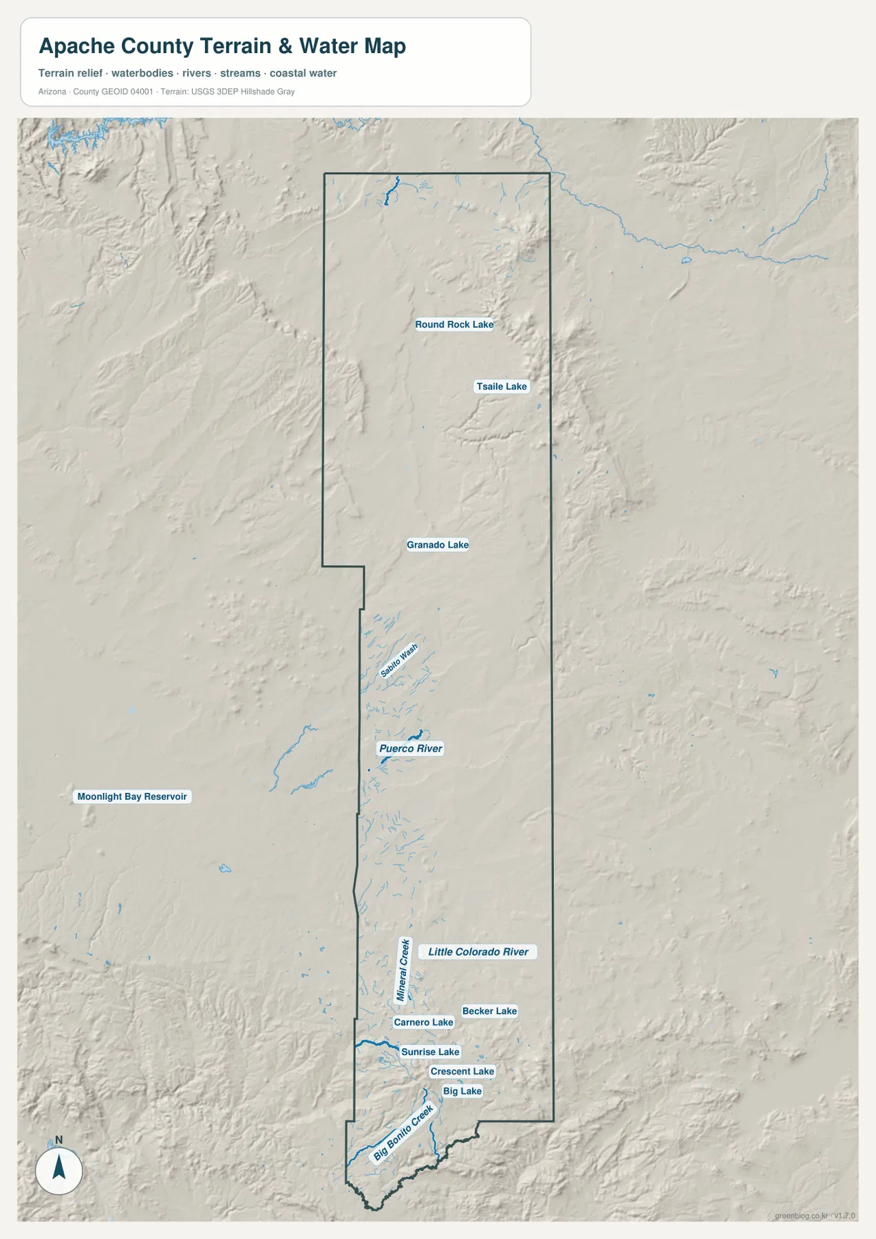
The terrain-and-water map shows a very different Apache County from the road map. In the north, named water features include Round Rock Lake and Tsaile Lake, with Ganado Lake appearing farther south. The Puerco River is labeled in the central part of the county. Farther south, the Little Colorado River becomes an important reference, and a denser group of creeks and lakes appears near the high terrain. Because shaded relief remains visible beneath the water features, the map also gives a sense of the valleys and broken ground that guide many of those channels.
The southern group includes Carnero Lake, Becker Lake, Sunrise Lake, Crescent Lake, and Big Lake, along with Mineral Creek and Big Bonito Creek. Their close spacing stands out when compared with the much larger gaps between named lakes in the north. Apache County’s own “Living in Apache County” page describes the Little Colorado River flowing from the Greer area toward Round Valley and St. Johns, which provides useful context for the concentration of water names in this part of the supplied map.
This map should be treated as a geographic reference rather than a flood, navigation, or water-rights map. It shows where selected rivers, creeks, lakes, and reservoirs are located in relation to terrain, but it does not provide depth, seasonal flow, legal access, flood probability, or safe boating information. A reader using the map for recreation can identify the general area of a lake or stream, then move to the appropriate land-management or local agency source for current conditions and regulations.
Elevation rises sharply in the White Mountains
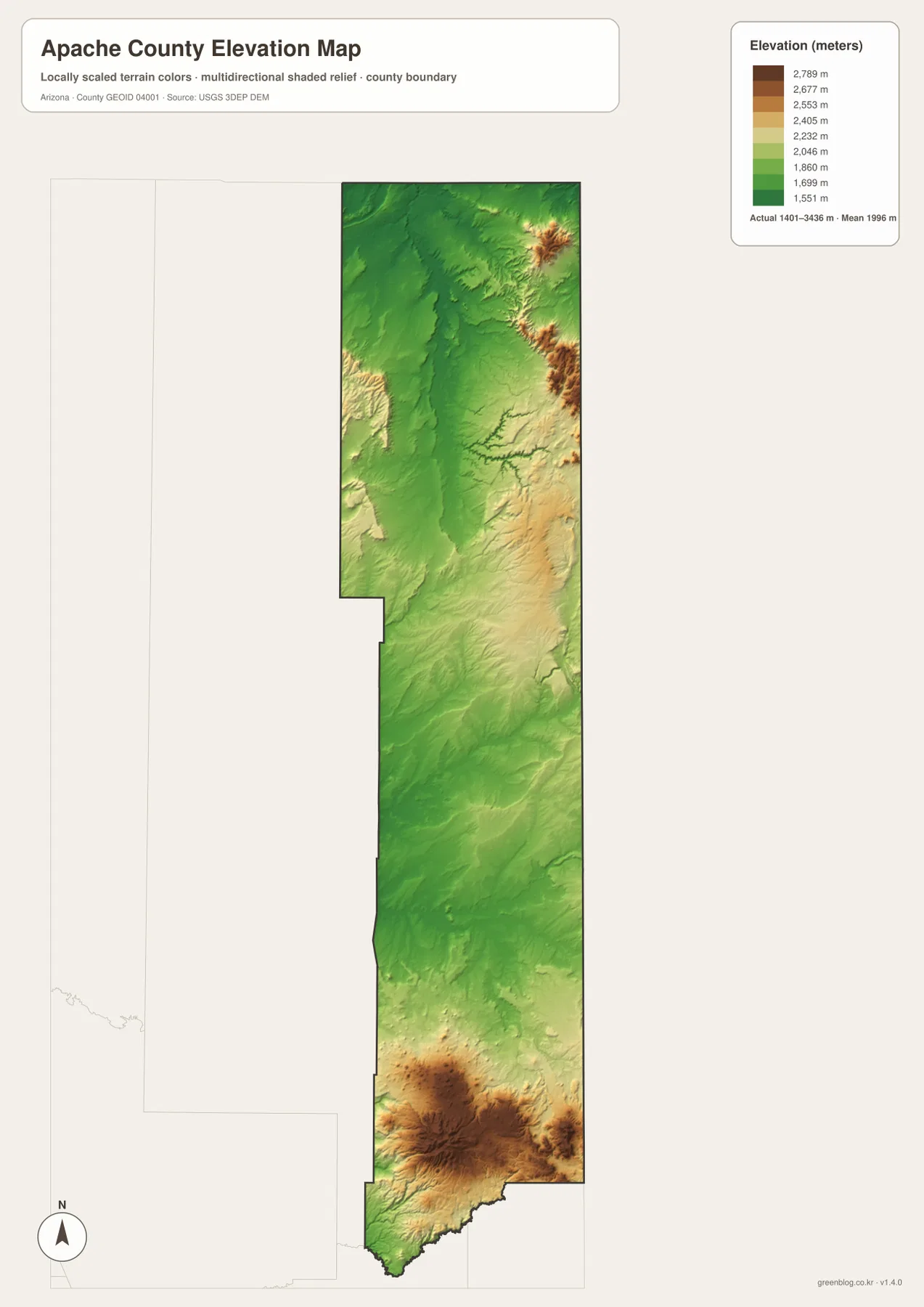
The elevation map provides the strongest visual contrast of the four maps. Its legend reports an actual county elevation range of about 1,401 to 3,436 meters, with a mean near 1,996 meters. Much of the north and center appears in green tones, while the southern end changes rapidly through yellow and brown. The high southern area corresponds with the White Mountains, which Apache County planning documents identify as the county’s most elevated terrain.
The map shows that the southern high country is not a single isolated peak. Broad high-elevation areas and multiple ridges occupy the lower end of the county, with valleys cutting through them. That pattern helps explain why the terrain-and-water map shows so many named creeks and lakes in the same general region. Big Lake, Sunrise Lake, Crescent Lake, and nearby water features sit in a part of Apache County where the elevation map is also much more varied than the broad central section.
A smaller high-elevation area is also visible near the northeastern side of the county, but the largest continuous zone of high terrain is in the south. The colors are best used for comparing one part of Apache County with another, not for reading an exact property elevation from the image. This is a generalized elevation surface rather than an engineering or survey product. Anyone who needs precise elevations should use the underlying USGS elevation data or a site-specific survey.
Choosing the right map for a specific Apache County question
Start with the county map when you need place names, county boundaries, and major roads in one view. It is the best option for locating Chinle, Houck, St. Johns, Springerville, or Eagar and then seeing which numbered highway is nearby. Use the city map when the question is narrower and you only need the relative positions of the three highlighted incorporated places. The simplified city view avoids road clutter, but it should not replace the county map for northern communities.
Choose the terrain-and-water map when rivers, lakes, or the relationship between drainage and landform is the main subject. It is particularly useful in the south, where the Little Colorado River and several named lakes can be compared with the surrounding relief. Choose the elevation map when the main question is how the county changes in height. The transition from the broad central green area to the high southern White Mountains is much clearer there than on the road map.
Using two maps together often provides the best explanation. A route question about Springerville can begin with the county map and then move to the elevation map to show why the surrounding terrain differs from the central county. A discussion of the Little Colorado River can use the water map first, then the elevation map to show the high terrain around its southern headwater region. The download archive contains the original JPG versions of all four supplied maps, so you can keep only the map you need or place two side by side in a document.
Frequently Asked Questions
Which road is the easiest reference for finding places across Apache County?
US 191 is the most useful north-south reference on the supplied county map. It passes the Chinle area and continues toward St. Johns and the Springerville-Eagar area. US 160 in the far north, Route 264 in the north-central section, I-40 near Houck, and US 60 in the south provide east-west reference points. Together, those roads make it much easier to estimate where a community sits along the county’s unusually long shape.
Why do so many named lakes appear in southern Apache County?
The water map places Big Lake, Crescent Lake, Sunrise Lake, Carnero Lake, Becker Lake, and several creeks in the southern part of the county. The elevation map shows that this same area is the county’s broad high-elevation zone in the White Mountains. Looking at the two maps together makes the relationship clear: the southern high country contains a denser group of mapped lakes and streams than the broad central portion. The map does not, however, show water depth or flood risk.
What is included in the Apache County download ZIP?
The archive contains four high-resolution JPG files: the county reference map, the city map, the terrain-and-water map, and the elevation map. Each original JPG is 2572 by 3638 pixels. The files match the map topics shown in the article, so the download can be used for larger viewing, printing, classroom material, or document layouts without relying on the smaller web images.
Map File Information
The download ZIP contains the original high-resolution JPG files for the four Apache County maps described on this page. Use the web maps for quick reference, then use the JPG files when you need a larger copy for printing or documents.
- File Type: JPG
Related Maps
Sources and references
County context is based on Living in Apache County and the Apache County Comprehensive Plan. Boundary, hydrography, and elevation reference sources include the U.S. Census Bureau TIGER/Line files, USGS National Hydrography, and the USGS 3D Elevation Program. For geographic context around Chinle, see the National Park Service Canyon de Chelly geodiversity overview.
Green Map creates custom-edited map images using open geographic data sources such as geoBoundaries, Natural Earth, OpenStreetMap, and government open data. These maps are edited visual materials, not raw data files, and are provided for education, documents, presentations, and graphic reference.