Across south-central Kansas, Butler County is easiest to read by first locating El Dorado near the middle of the supplied maps. Andover, Rose Hill, and Augusta cluster toward the southwest, while Potwin and Elbing mark the northwest, Douglass anchors the south, and Cassoday gives the northeast a clear reference. U.S. 54 and 77 meet around El Dorado, Kansas 177 reaches toward Cassoday, and U.S. 400 crosses the southern half near Augusta and Leon. The four high-resolution JPG maps shown on this page can also be downloaded together from the map file box below.
The road pattern is only part of the county’s geography. El Dorado Lake occupies a large basin north of the county’s center, with Walnut River and West Branch Walnut River extending away from it, while Whitewater River forms a separate western drainage. Farther east, the Little Walnut River system cuts many smaller valleys into rising ground. The elevation map shows an actual range of about 350 to 511 meters, with a mean near 424 meters, and the sharpest high ground concentrated along the eastern side of the county.
This west-to-east contrast gives Butler County a useful map-reading story. The southwestern cities sit on lower, more open terrain near the Wichita side of the county, El Dorado occupies a central position beside its large reservoir and major highways, and the eastern half climbs into the more rugged Flint Hills landscape. Looking at roads, rivers, settlements, and elevation together makes the county much easier to understand than treating each place name as an isolated point.
Table of Contents
Start with El Dorado, then follow the county outward
El Dorado is the strongest orientation point on the general map because several major routes converge there. U.S. 54 approaches from the Towanda side, crosses the city, and continues east across tributaries and rolling terrain. U.S. 77 runs north-south through the same area, while Kansas 196 enters from the northwest and Kansas 177 leaves toward Cassoday in the northeast. This concentration of route numbers makes it easy to locate the rest of the county once El Dorado has been found.
The southwest has a different pattern. Augusta sits on U.S. 400, Andover lies close to the western county line and the I-35 corridor, and Rose Hill is south of Andover. Douglass is farther south, separated from the denser suburban edge by a wider rural area. These places show that Butler County does not have one continuous urban belt; instead, the western and central parts contain several distinct population centers connected by major roads and smaller local routes.
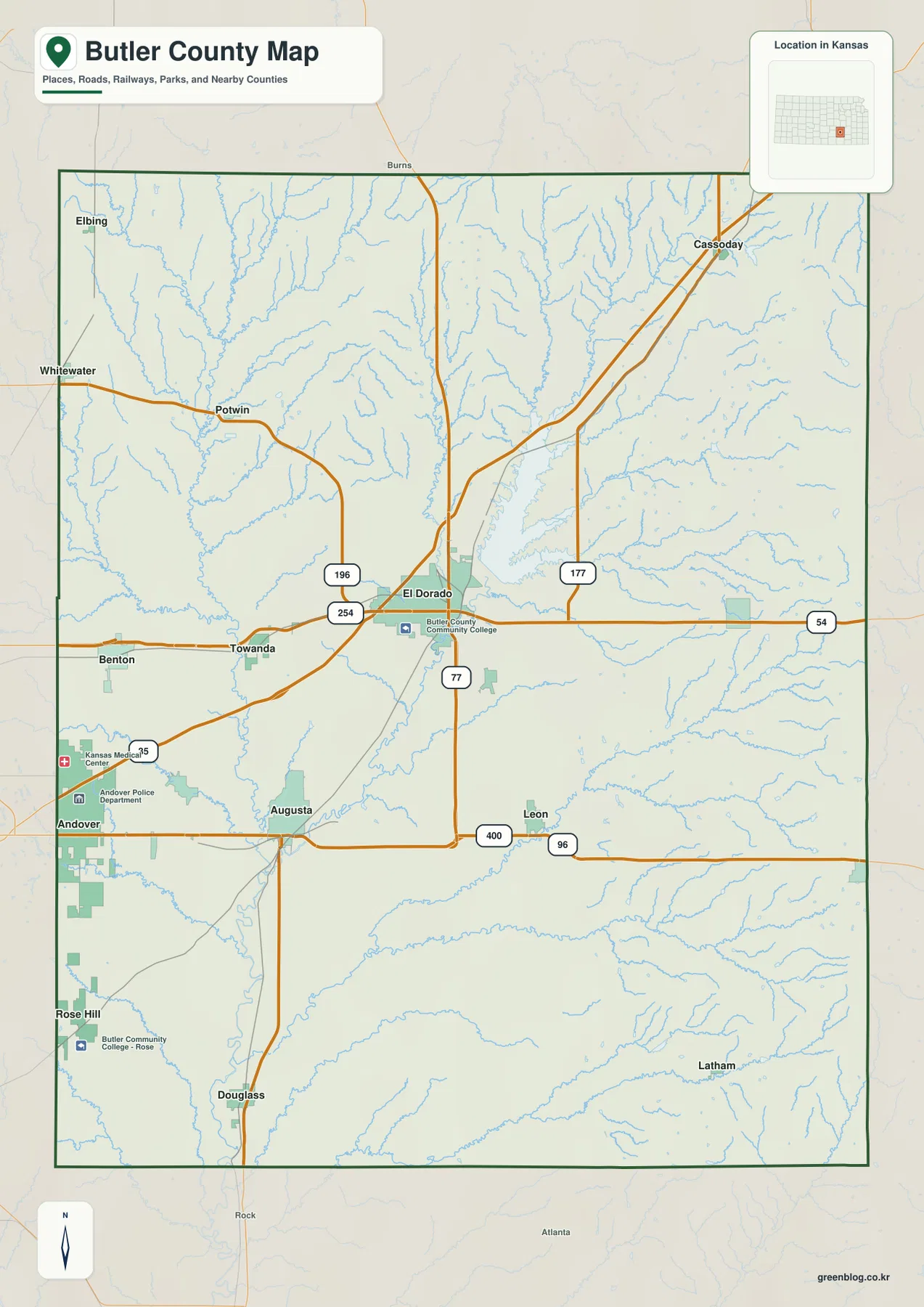
Smaller places help define the county’s outer sections. Elbing and Potwin make the northwest easier to identify, while Cassoday sits well away from the southwestern population cluster and marks the road into the Flint Hills. Leon lies east of the central road network, and Latham appears farther southeast where settlement labels become sparse and the drainage pattern becomes more prominent. These points are useful because the county is large enough that a map focused only on its three biggest cities would leave much of the eastern landscape without an obvious reference.
The general map is the best first choice for county boundaries, named places, and numbered highways, but it is not a live navigation product. Construction, closures, and current travel time can change, and the pale stream network does not show the depth of the valleys very clearly. After locating a route or town here, the water and elevation maps add the natural terrain that the road layer simplifies.
A Split City Pattern from Andover to El Dorado and Augusta
The ranked city map highlights six places and gives the values printed in the supplied graphic: Andover 15,965, El Dorado 12,769, Augusta 9,216, Rose Hill 4,246, Towanda 1,668, and Douglass 1,603. Those figures are most useful as the map’s own comparison rather than as a substitute for the newest population estimate. They immediately show that the county’s three largest mapped centers are not all grouped in one location.
Andover is placed on the far western side, El Dorado occupies the central-northern part of the county, and Augusta stands between them but farther south. Rose Hill adds another western center, while Towanda lies west of El Dorado and Douglass anchors the south. The result is a settlement pattern with several separate nodes rather than a single city surrounded by progressively smaller suburbs. This is one reason the highway network matters so much when reading the county.
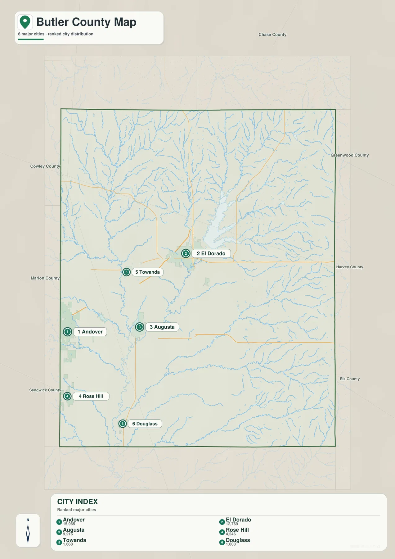
Natural features add another layer to that distribution. El Dorado lies close to El Dorado Lake and the Walnut River system, Augusta is near the lower Walnut River corridor, and Towanda occupies ground between the Whitewater and Walnut drainages. Andover and Rose Hill sit on the lower western side of the county where small tributaries are present but the large eastern ridges are still distant. The city map does not try to explain those landforms, but its place labels become more meaningful when compared with the water and elevation views.
The ranked city image should not be read as a commuting map or an urban-service boundary. Screen distance is not driving distance, and the printed city values may not match a later official estimate. Use it to compare the relative position and scale of the mapped cities, then return to the general map for roads and to current Census or local sources for updated statistics.
El Dorado Lake, Walnut River, and the Western Whitewater Drainage
El Dorado Lake is the largest water body shown in the supplied water-and-terrain map. Its long, branching shape fills a basin north of the county’s center, and Walnut River continues south from that area toward Augusta. West Branch Walnut River descends through the central-western part of the county and joins the larger system, while Whitewater River and West Branch Whitewater River form another major set of valleys farther west. Seeing these drainages together explains why the central and western landscape is divided by more low corridors than the road map first suggests.
The eastern half is organized around a different network. Little Walnut River crosses the southeast, and its South Branch, North Branch, and Mid Branch extend into many smaller tributaries. Rather than one broad valley dominating the entire side of the county, these streams repeatedly cut into the higher Flint Hills terrain. Fox Lake and Rogers Pond provide additional reference points in the northeast and east, while Rock Creek appears near the southern edge.
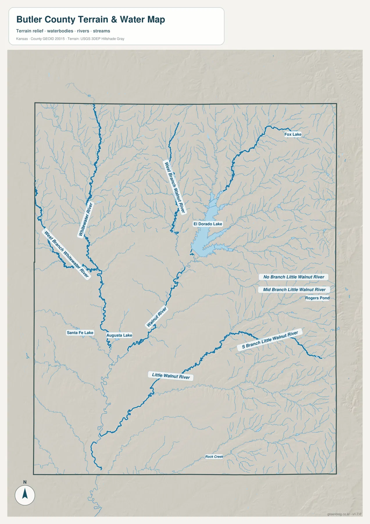
Augusta Lake and Santa Fe Lake are shown near the southwest, giving that part of the county water landmarks that are easy to compare with Augusta and the U.S. 400 corridor. Around El Dorado Lake, the shoreline has many arms where tributaries enter the reservoir, while farther east the stream pattern becomes finer and more deeply embedded in the hills. These differences make the water map especially useful for explaining why two places at similar north-south positions can have very different local terrain.
This is a geographic reference map, not a flood forecast, navigation chart, or legal water-boundary product. It does not show current lake level, safe boating routes, access status, fishing rules, or real-time stream conditions. Those questions require current information from the appropriate park, weather, water, or local agency. Here, the map’s role is to show where the major rivers, tributaries, and named water bodies sit within the county.
From 350 Meters in the Valleys to 511 Meters on the Eastern Ridges
The elevation map gives Butler County an actual displayed range of roughly 350 to 511 meters and a mean of about 424 meters. Green colors dominate the western and central valleys, while yellow, orange, and brown become more common toward the east. The highest terrain is concentrated close to the eastern boundary, creating a clear rise of more than 160 meters from the county’s lower corridors to its highest ridges.
El Dorado Lake occupies a lower basin that stands out against the surrounding rolling ground. South of the reservoir, Walnut River continues through a green corridor toward Augusta. The eastern tributaries of Little Walnut River are different: they cut narrow green valleys into higher yellow and brown uplands. This repeated ridge-and-valley pattern is one of the most useful clues that the eastern half belongs to the Flint Hills landscape described by the Kansas Historical Society.
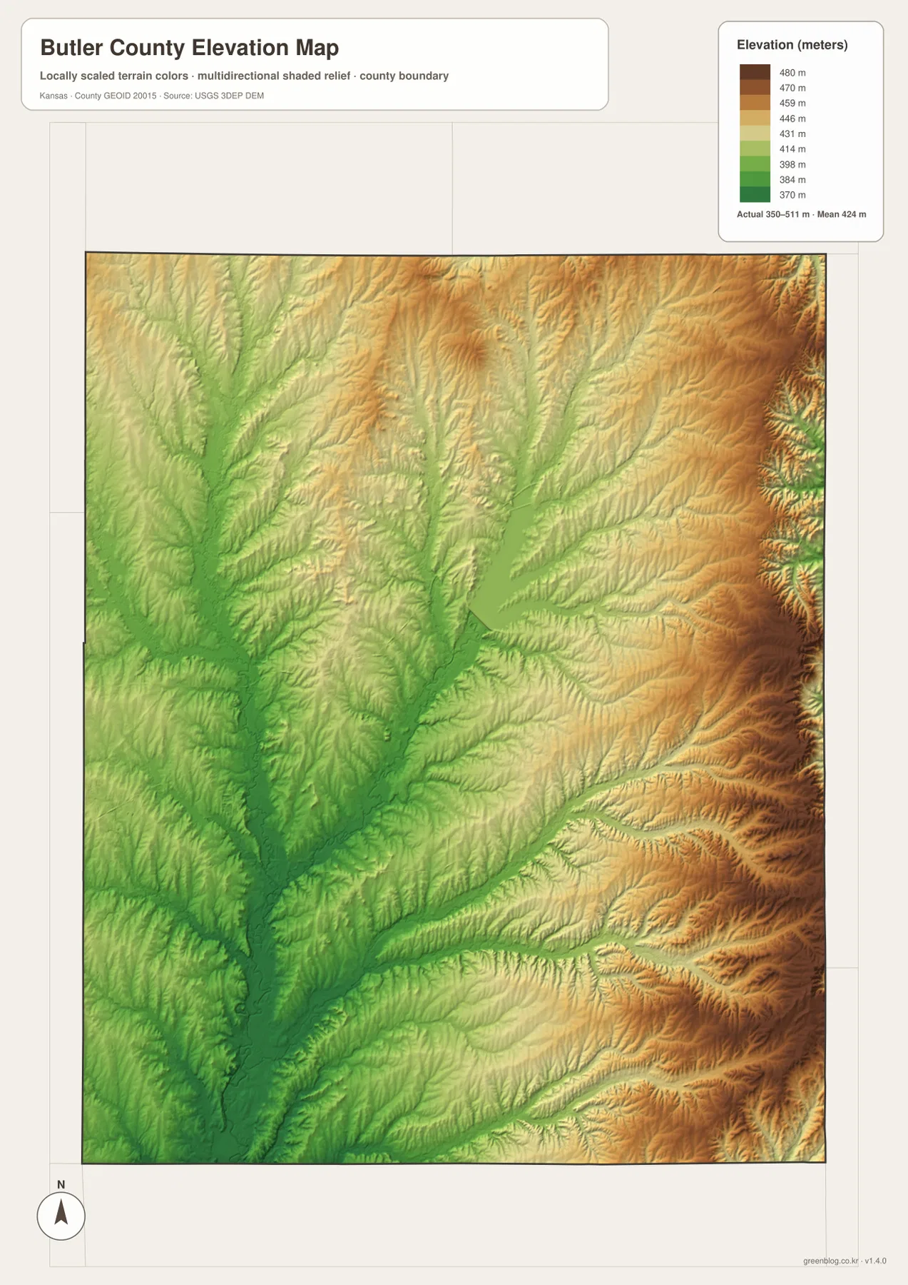
The contrast also helps explain why the county feels different from west to east. Andover and Rose Hill lie in the lower western portion, and the Augusta-El Dorado corridor follows relatively low drainage ground. Leon and Latham are surrounded by more pronounced ridges and tributary cuts. A highway line can look almost straight on the general map, but the elevation surface shows that the route may cross a succession of small valleys and higher divides.
The elevation layer is designed for broad geographic comparison. Its colors and shaded relief make slopes, valleys, and ridges easier to see, but they should not be treated as parcel-level elevations or engineering measurements. Surveying, drainage design, construction, and other precision work require the original USGS elevation data or professional field measurements.
Following U.S. 54, U.S. 77, and Kansas 177 across changing ground
U.S. 54 provides the clearest east-west reference through El Dorado. West of the city, it passes through the more open central-western part of the county; east of El Dorado, the route crosses many tributaries as the land becomes more rolling. U.S. 77 gives the map a north-south backbone, while Kansas 177 reaches northeast toward Cassoday through higher terrain. Comparing these routes with the elevation layer is a simple way to see how transportation lines cut across, rather than erase, the county’s natural relief.
The southwest depends heavily on U.S. 400, I-35, and the local road network around Andover and Augusta. This part of the county contains more of the mapped population centers and has a visually denser road pattern, yet it is still crossed by branches leading toward Whitewater River and Walnut River. Douglass sits farther south, where the settlement pattern thins and the smaller drainage lines become easier to notice.
East of Leon, the balance changes. Town labels become sparse while the Flint Hills ridges and tributary valleys dominate the map. Latham is one of the few named places providing a southern-eastern reference, and many local roads thread through a landscape that looks much more dissected on the elevation view than on the general map. For a classroom comparison or a local geography project, the west-east shift from denser settlement to higher rolling terrain is one of the most distinctive features to highlight.
Where the high-resolution files add the most detail
The web previews are convenient for quick orientation, but the original JPG files are better for small road labels, short tributaries, shoreline details, and printed use. Each supplied original is 2572 by 3638 pixels. Around El Dorado, zooming in makes the junctions among U.S. 54, U.S. 77, Kansas 196, and Kansas 177 easier to follow. The water file preserves many branches around El Dorado Lake and the Little Walnut system that can look faint on a reduced screen.
For the west, compare Andover, Rose Hill, Augusta, Towanda, Whitewater River, and West Branch Walnut River. For the east, use Leon, Latham, the Little Walnut tributaries, and the highest elevation colors to understand the Flint Hills side of the county. These are more useful comparisons than treating the four files as interchangeable versions of the same map, because each one emphasizes a different part of the county’s geography.
The files work well for general reference, personal study, classroom handouts, presentations, and ordinary printing. They are not substitutes for parcel records, legal boundary surveys, flood determinations, engineering plans, or live traffic information. When a decision depends on current conditions or legal precision, the appropriate official source should take priority over the downloadable maps.
Frequently Asked Questions
Which map is best for seeing El Dorado Lake and Walnut River together?
The water-and-terrain map is the most direct choice because it shows the complete outline of El Dorado Lake along with Walnut River, West Branch Walnut River, and the nearby tributary network. If you also need the surrounding highways and city labels, locate El Dorado on the general map first and then compare the same area on the water map.
Where is the highest ground in Butler County on the supplied elevation map?
The highest colors are concentrated along the eastern side of the county, especially near the deeply cut Flint Hills ridges. The displayed elevation range is about 350 to 511 meters, with lower ground following the Walnut and Whitewater river valleys farther west. The layer is suitable for broad terrain comparison, not precise engineering or parcel measurements.
What does the Butler County download ZIP contain?
The archive contains four high-resolution JPG files matching the maps on this page: the general county map, ranked city map, water-and-terrain map, and elevation map. Each original is 2572 by 3638 pixels, making the files useful for zooming, ordinary printing, classroom work, presentations, and general geographic reference.
Map File Information
Download the high-resolution JPG originals corresponding to the Butler County general map, ranked city map, water-and-terrain map, and elevation map shown on this page.
- File Type: ZIP containing 4 JPG files
Related Maps
Sources and References
Boundary and base geography can be checked through the U.S. Census Bureau TIGER/Line Shapefiles, waterways through USGS National Hydrography, and elevation through the USGS 3D Elevation Program. County information is available from the official Butler County, Kansas website and the Kansas Historical Society Butler County profile, which describes the county as part of the Flint Hills region and identifies El Dorado as the county seat. Geographic descriptions on this page are centered on features visible in the supplied maps.
Green Map creates custom-edited map images using open geographic data sources such as geoBoundaries, Natural Earth, OpenStreetMap, and government open data.
These maps are edited visual materials, not raw data files, and are provided for education, documents, presentations, and graphic reference.