Wilkinson County sits in the far southwestern part of Mississippi, where a broad, low Mississippi River margin gives way to a much more broken landscape of ridges, ravines, and small stream valleys. Woodville, the county seat, provides the clearest central reference on the general map, while Centreville and Crosby help define the eastern and southeastern side of the county. The four supplied maps are most useful when read together: one establishes roads and settlements, another compares selected town locations, a third emphasizes rivers and lakes, and the elevation surface shows how sharply the land rises away from the western lowlands.
High-resolution map files are available from this page, not just on-screen previews. The WebP images in the article are convenient for quick viewing, while the download box farther down provides an A3 JPG set in a single ZIP for printing, enlarging, or keeping offline. A practical way to use the page is to begin with Woodville and the numbered roads, then compare the water and elevation maps. That sequence makes the county’s strongest geographic contrast—the low western river side versus the dissected interior and eastern uplands—much easier to see.
Table of Contents
Woodville anchors the road map while the western edge bends with the river lowland
On the county reference map, Woodville is the most useful starting point because several prominent road lines meet or pass through the central part of the county. US 61 is labeled north of Woodville and continues through the county, while other numbered routes fan toward the west, northeast, east, and southeast. Route labels visible on the map include 24, 563, 33, 19, and 969. Crosby appears near the northeastern edge, and Centreville lies farther south along the eastern side. Reading those labels from Woodville outward gives a clearer sense of direction than trying to memorize each road in isolation.
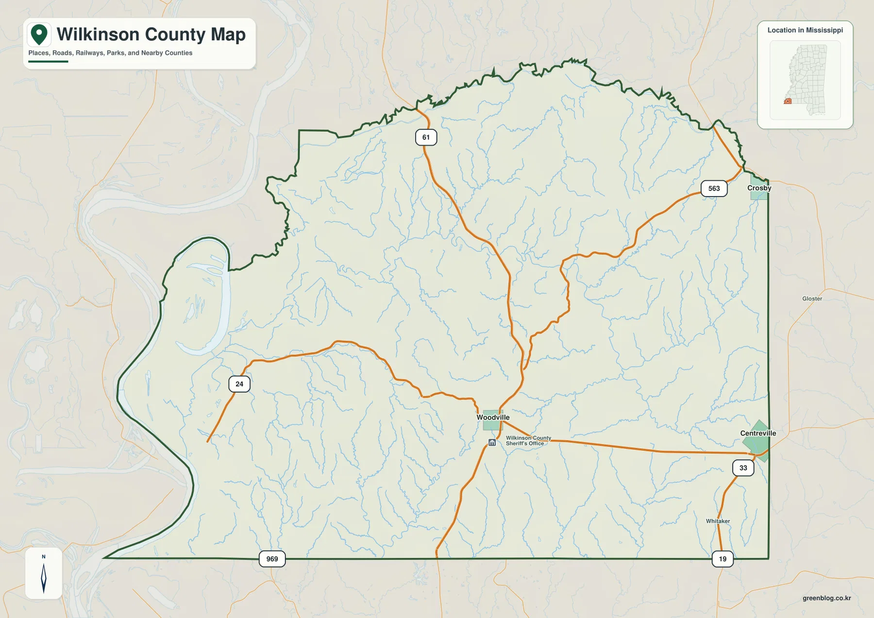
The western boundary is visually different from the straighter lines on much of the east and south. It makes a broad series of curves beside the Mississippi River lowland, and the surrounding background also shows water features outside the county outline. Inside the boundary, thin blue stream lines are widespread rather than confined to one corridor. The general map is therefore useful for orientation—where Woodville, Crosby, Centreville, and the main road labels sit in relation to one another—but it should not be treated as a parcel survey or a legal property-boundary document.
The map also gives some regional context beyond the county line. Nearby labels such as Gloster appear to the east, while the Mississippi locator inset confirms Wilkinson County’s position in the southwestern corner of the state. That context matters because the county is not organized around a dense chain of large towns. Instead, a few named communities are separated by long stretches of rural land, small roads, wooded drainage lines, and terrain that becomes increasingly uneven away from the western river side.
Centreville is the city-map hub, but Woodville remains the county seat
The city-connections map answers a different question from the general road map. It selects Centreville as a hub and draws simple connectors to Woodville and Crosby. Those connector values are straight-line distances, not driving distances. The map shows Woodville about 14 miles from Centreville and Crosby about 13 miles away in a different direction. A road trip between the same places can be longer because actual highways and local roads do not follow a perfectly straight path.
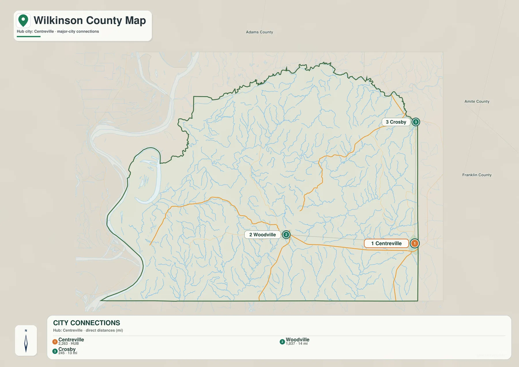
This distinction also prevents an easy misunderstanding: the “hub” symbol does not identify the county seat. Woodville is the county seat; Centreville is simply the reference point chosen for this particular distance graphic. The map is especially helpful for seeing direction. Woodville lies west of Centreville, whereas Crosby sits much farther north along the eastern edge. The surrounding labels for Adams County, Amite County, and Franklin County make that eastern and northern orientation easier to place within southwestern Mississippi.
Because the connectors ignore the shape of the road network, the city map works best as a geographic comparison rather than a route planner. It can answer questions such as whether Woodville or Crosby is farther from Centreville in a straight line, or how the three places are arranged inside the county. For turn-by-turn travel, current road conditions, bridge access, or exact mileage, a transportation map or navigation service is the appropriate next step.
A dense network of streams drains toward the Mississippi River side
Water features become much more prominent on the terrain-and-water map. The western side contains the broad Mississippi River margin and a cluster of named lakes, including Blue Lake, Big Lake, Lake Mary, Foster Lake, and Artonish Lake. Their concentration on the low western side contrasts with the branching creeks and narrow valleys farther inland. The map makes that difference visible without requiring technical hydrology: large water bodies occupy the river lowland, while numerous small channels cut through the higher interior.
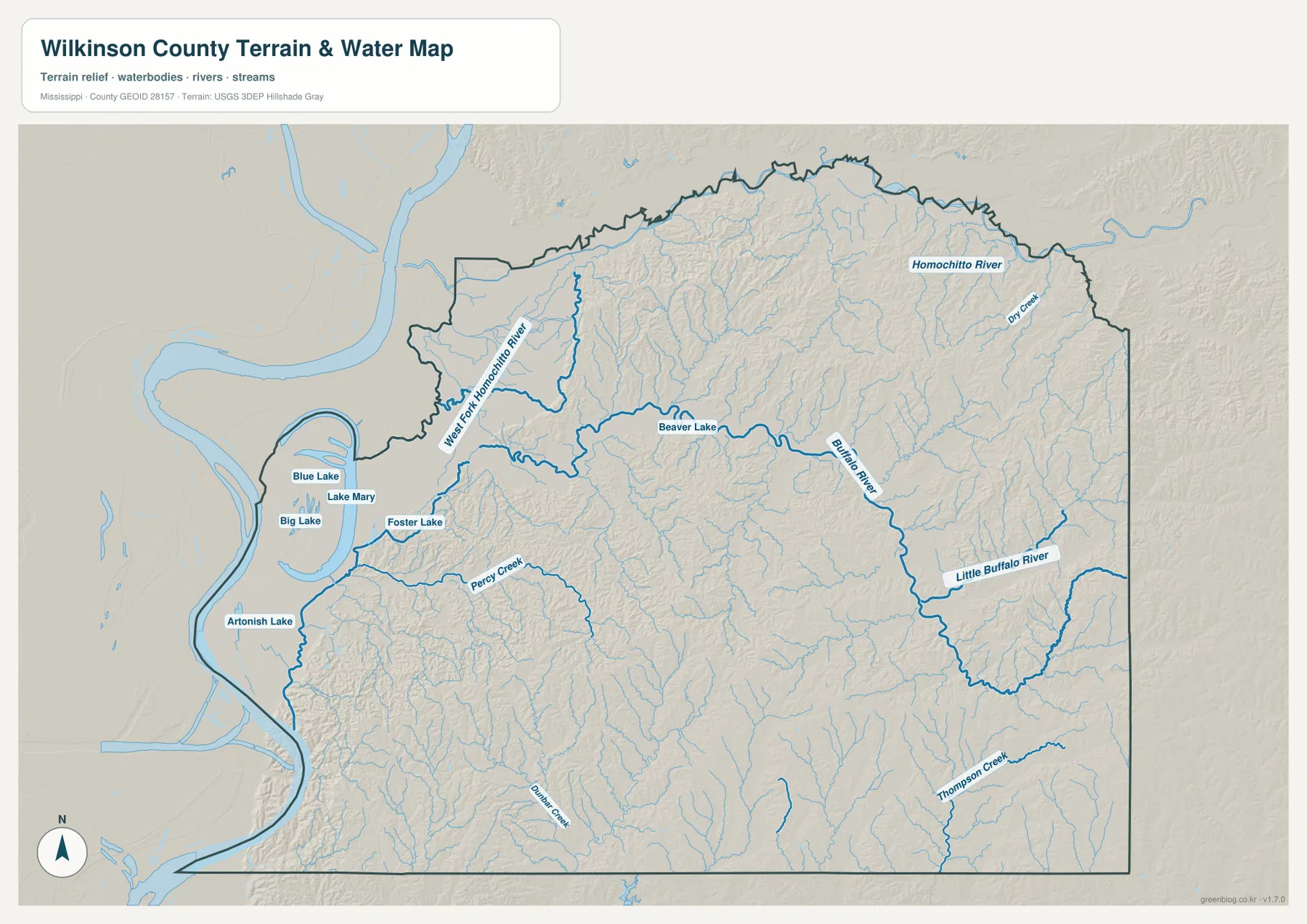
Across the north, the Homochitto River and West Fork Homochitto River are among the strongest labeled channels. Farther south and east, the Buffalo River crosses the county and connects visually with the Little Buffalo River system. Other named features include Dry Creek, Percy Creek, and Thompson Creek, while many additional tributaries appear as thinner unlabeled lines. The result is a county that looks finely divided by drainage, particularly where the terrain is hilly. The water map is valuable for recognizing these relationships, but it does not show flood probability, water depth, navigable channels, or property restrictions.
Clark Creek Natural Area provides a well-known local example of the ravine landscape described in the county’s existing source material. Its official park information is useful for understanding why steep ravines and waterfalls are associated with this part of southwestern Mississippi. The supplied water preview, however, is a county-scale reference rather than a trail map, so it should not be used to locate a trailhead, determine whether a path is open, or infer the exact park boundary. Those details belong to the current natural-area guidance.
Elevation rises sharply away from the western floodplain
The elevation map makes the county’s west-to-interior contrast even clearer. Its legend reports an actual range of roughly 11 to 136 meters, with a mean near 67 meters. The western river side is dominated by dark green low elevations and broad, relatively smooth surfaces. Moving inland, the terrain quickly becomes more textured. Numerous narrow ridges and valleys appear across the center, north, and especially the east and south, where tan and brown colors mark higher ground.
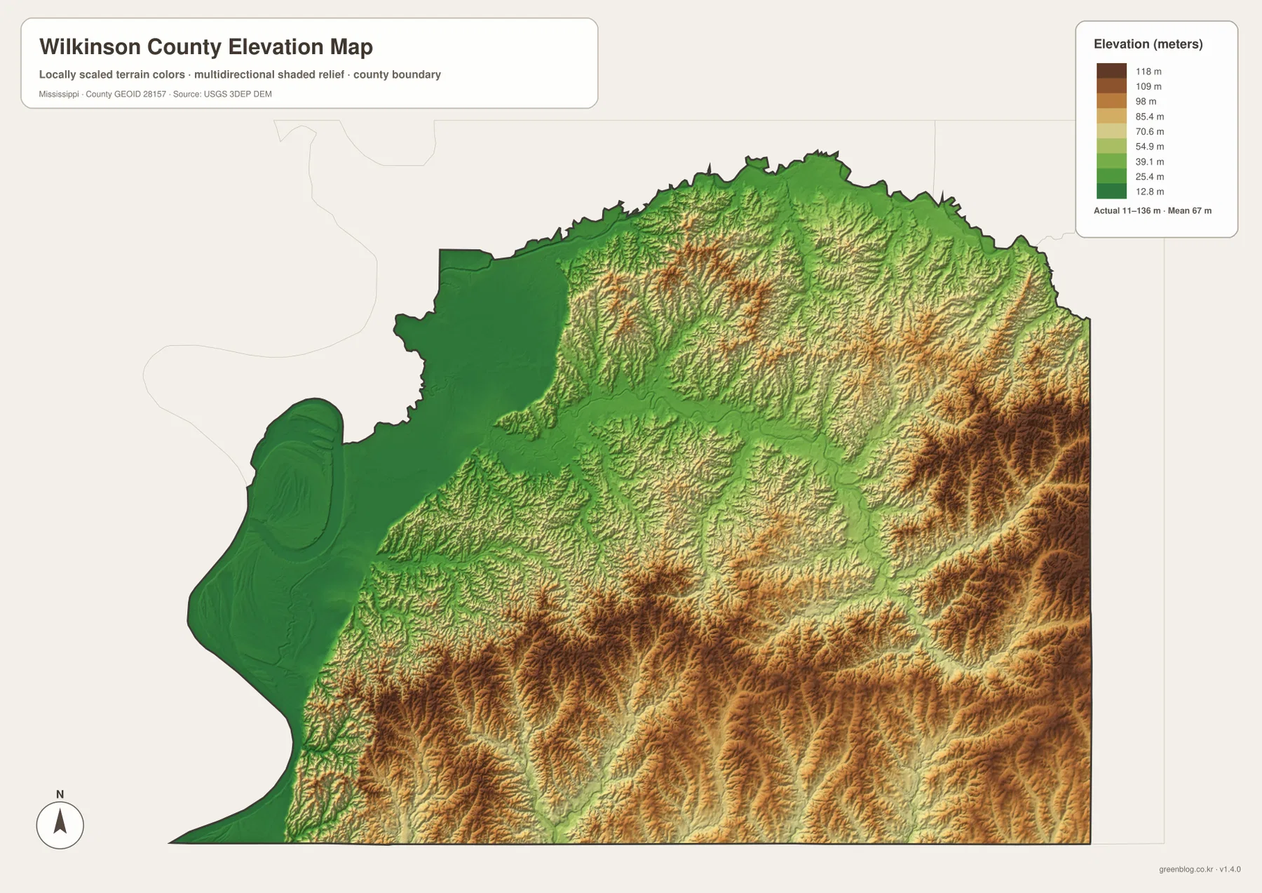
The highest-looking terrain is not concentrated in one isolated peak. Instead, elevated ridges occur in repeated bands and patches, particularly toward the eastern and southeastern portions of the county and across parts of the south. That pattern matches what the water map suggests: many small channels occupy valleys between ridges, producing a closely dissected surface rather than a single broad slope. The north also contains substantial relief even though it is less uniformly high than some of the southeastern ridges.
This elevation image is designed for county-scale comparison, not engineering or surveying. The color surface has been generalized so that terrain differences are easy to see, which means it should not be used to assign a precise elevation to a house lot, road grade, construction site, or property corner. For those tasks, the underlying USGS elevation data or a professional survey is more appropriate. For education, trip planning, regional comparison, and understanding why the drainage network is so dense, the map provides useful context.
Population and area figures explain the large amount of open rural space
The existing county data package lists a 2020 census population of 8,587 and a July 2025 estimate of 7,582. It also records 678.012 square miles of land and 9.754 square miles of water from the 2025 Gazetteer. Dividing the 2020 population by that land area produces a county-level density of about 12.7 residents per square mile. The dates matter: the census population and the later estimate are separate measures, and the density is an overall average rather than a description of how people are distributed within individual towns or rural areas.
Those numbers make more sense when placed beside the maps. Woodville, Centreville, and Crosby are separated by sizable areas that contain stream networks, rural roads, lowlands, and ridges instead of a continuous urban pattern. The western side is physically different from the eastern uplands, so a single county-wide density figure cannot describe every part of Wilkinson County equally well. The maps add that missing geographic context by showing where named places sit and how the terrain between them changes.
- County seat: Woodville
- FIPS code: 28157
- 2020 census population: 8,587
- July 2025 population estimate: 7,582
- 2025 Gazetteer area: 678.012 sq mi land and 9.754 sq mi water
- Elevation map range: about 11–136 m, with a mean near 67 m
Which Wilkinson County map is most useful for your task?
For a quick location check, start with the county reference map because it combines the boundary, named communities, numbered roads, and a broad network of streams. If the question is specifically about the relative position of Centreville, Woodville, and Crosby, the city-connections image is more direct, as long as its 13- and 14-mile labels are understood as straight-line distances. The terrain-and-water map is better when rivers, creeks, or the lake cluster near the Mississippi River side matter. The elevation map is the clearest choice when the goal is to compare the low western floodplain with the higher and more dissected interior.
Using the maps together is particularly helpful for Wilkinson County because the same feature can look very different depending on what is emphasized. The western edge appears as an unusual county shape on the boundary map, a lake-rich river lowland on the water map, and a broad low-elevation zone on the elevation map. The eastern side, by contrast, contains Crosby near the boundary, a dense network of tributaries, and more prominent ridges. That combination is more informative than repeating a generic list of map uses.
For printing or offline use, the download package is preferable to saving the WebP previews from the page. It contains four high-resolution A3 JPG files corresponding to the county, city-connections, terrain-and-water, and elevation maps shown here. The images are suitable for general reference and enlargement, while time-sensitive transportation information, trail access, legal boundaries, flood conditions, and survey-grade elevation should always be checked against the appropriate current official source.
Frequently Asked Questions
Why does the city map use Centreville as the hub if Woodville is the county seat?
The hub is only a comparison point used by the city-connections graphic. Woodville remains the county seat. Selecting Centreville as the hub makes it easy to compare its straight-line distance and direction to Woodville and Crosby; it does not assign Centreville an administrative role.
Are the 13-mile and 14-mile labels driving distances?
No. They are straight-line distances from Centreville to the selected places. Driving mileage can be longer because roads curve, cross streams, and follow available junctions. Use a current road map or navigation service when exact travel distance and time matter.
Can the water or elevation map be used for flood, construction, or property decisions?
No. The water map is a county-scale reference to rivers, lakes, and streams; it is not a flood-hazard or navigation product. The elevation map is a generalized terrain surface rather than a survey-grade measurement. Floodplain, engineering, construction, and property questions require the appropriate official or professional source.
Map File Information
The ZIP contains four high-resolution A3 JPG files matching the county, city-connections, terrain-and-water, and elevation maps shown on this page.
- Included Files: 4 high-resolution A3 JPG map files shown in this article
- File Type: JPG files in a ZIP archive
- Intended Use: Printing, education, presentations, and map-based projects
Related Maps
Sources and references
- U.S. Census Bureau QuickFacts – Wilkinson County, Mississippi
- U.S. Census Bureau Gazetteer Files
- Mississippi Department of Transportation official highway map
- Mississippi Department of Wildlife, Fisheries, and Parks – Clark Creek Natural Area
- USGS National Hydrography
- USGS 3D Elevation Program
Green Map creates custom-edited map images using open geographic data sources such as geoBoundaries, Natural Earth, OpenStreetMap, and government open data. These maps are edited visual materials, not raw data files, and are provided for education, documents, presentations, and graphic reference.