Winston County sits in east-central Mississippi, where Louisville forms the clearest road and settlement reference and Noxapater provides a second anchor farther south. The county map quickly shows that this is not a flat, empty block between county lines. Major roads converge around Louisville, small streams branch across nearly every part of the county, and the elevation surface is cut by repeated ridges and valleys. To the north and east, the Noxubee River system and its tributaries become especially useful for understanding how the terrain is organized.
This page combines a county reference map, a city map, a terrain-and-water map, and an elevation map. The on-page previews use WebP for faster viewing, while the download box near the end provides a ZIP containing four high-resolution A3 JPG files for printing, presentations, or closer inspection. A practical way to use the set is to start with Louisville and the state highways, then compare the creek network with the elevation map to see why the county is divided into so many narrow valleys and wooded ridges.
Table of Contents
Louisville as the Road Reference for Winston County
Louisville is the easiest place to begin because several important routes meet or pass through the city. MS 14 runs across the county in an east-west direction and crosses Louisville, while MS 25 approaches from the southwest and continues northward. South of Louisville, MS 15 leads toward Noxapater. The map also labels MS 490 east of Noxapater, MS 397 in the southeast, MS 393 along the southern edge, and MS 395 toward the southwest. These route numbers make it possible to orient the county without relying on every minor local road.
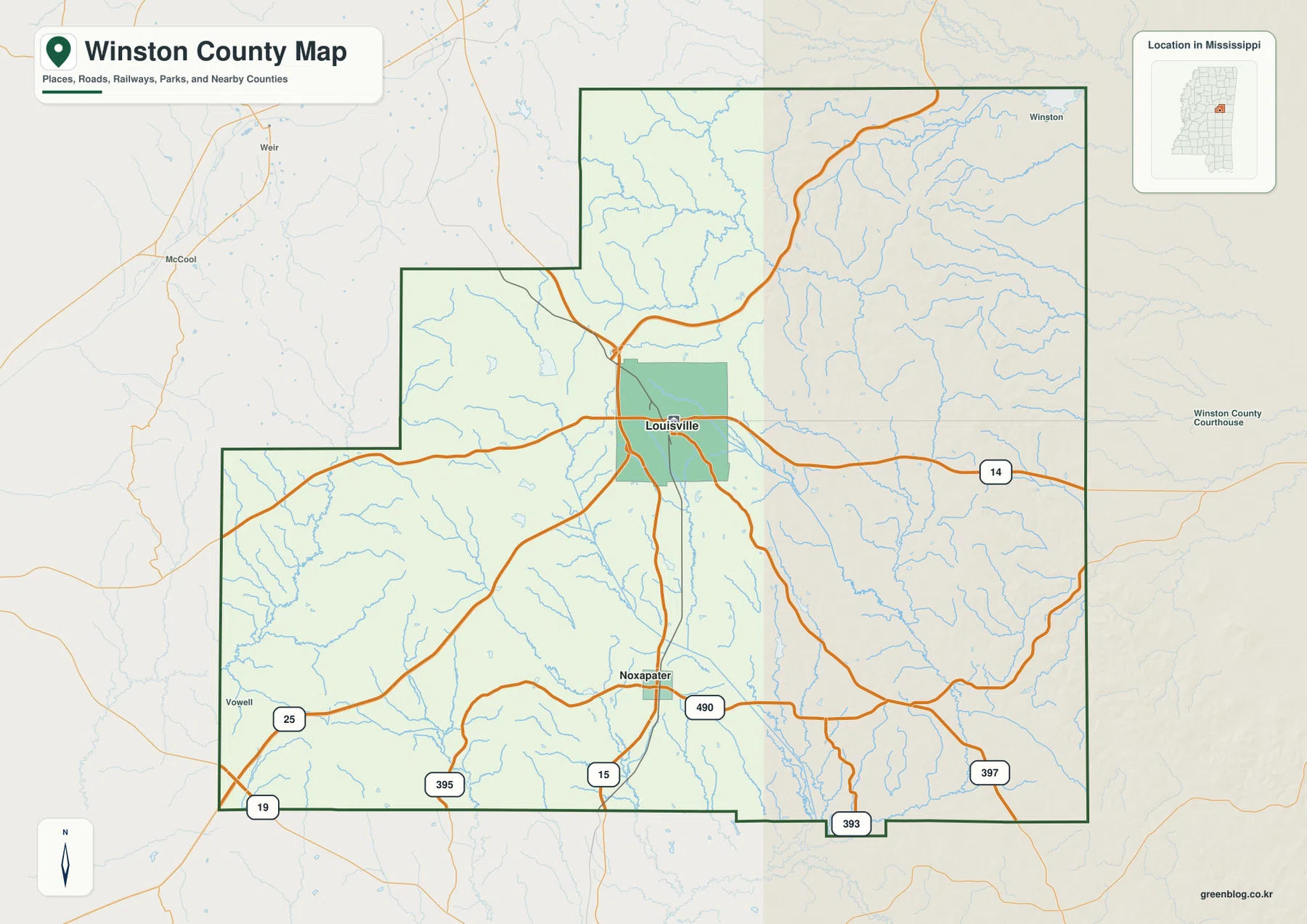
The county outline is irregular rather than rectangular. There are stepped sections on the west and northwest sides and a small projection along the southern boundary. The surrounding labels also help place Winston County within the region: Choctaw and Oktibbeha counties are shown to the north, Attala and Neshoba to the west, Noxubee and Kemper to the east, and Leake toward the southwest. Those neighboring names are useful when tracing a route beyond the county line, but the map is not a parcel or property-boundary document.
The density of blue stream lines is another feature that stands out even on the general map. Roads often cross or follow the broader valleys, while Louisville sits in an area where road connections are much more concentrated than in the outer parts of the county. Noxapater serves a different function on the map: it is the main labeled place in the southern part of the county and helps distinguish the MS 15 and MS 490 corridor from the road network around Louisville.
The Louisville–Noxapater Settlement Pattern
The city map simplifies the county to its two ranked major places. Louisville is marked first and Noxapater second, with Louisville in the central-northern part of the county and Noxapater well to the south. The two are not shown as adjoining urban areas; instead, a broad rural landscape and many streams separate them. This makes the city map useful for understanding settlement spacing before looking at the more detailed roads and waterways on the other maps.
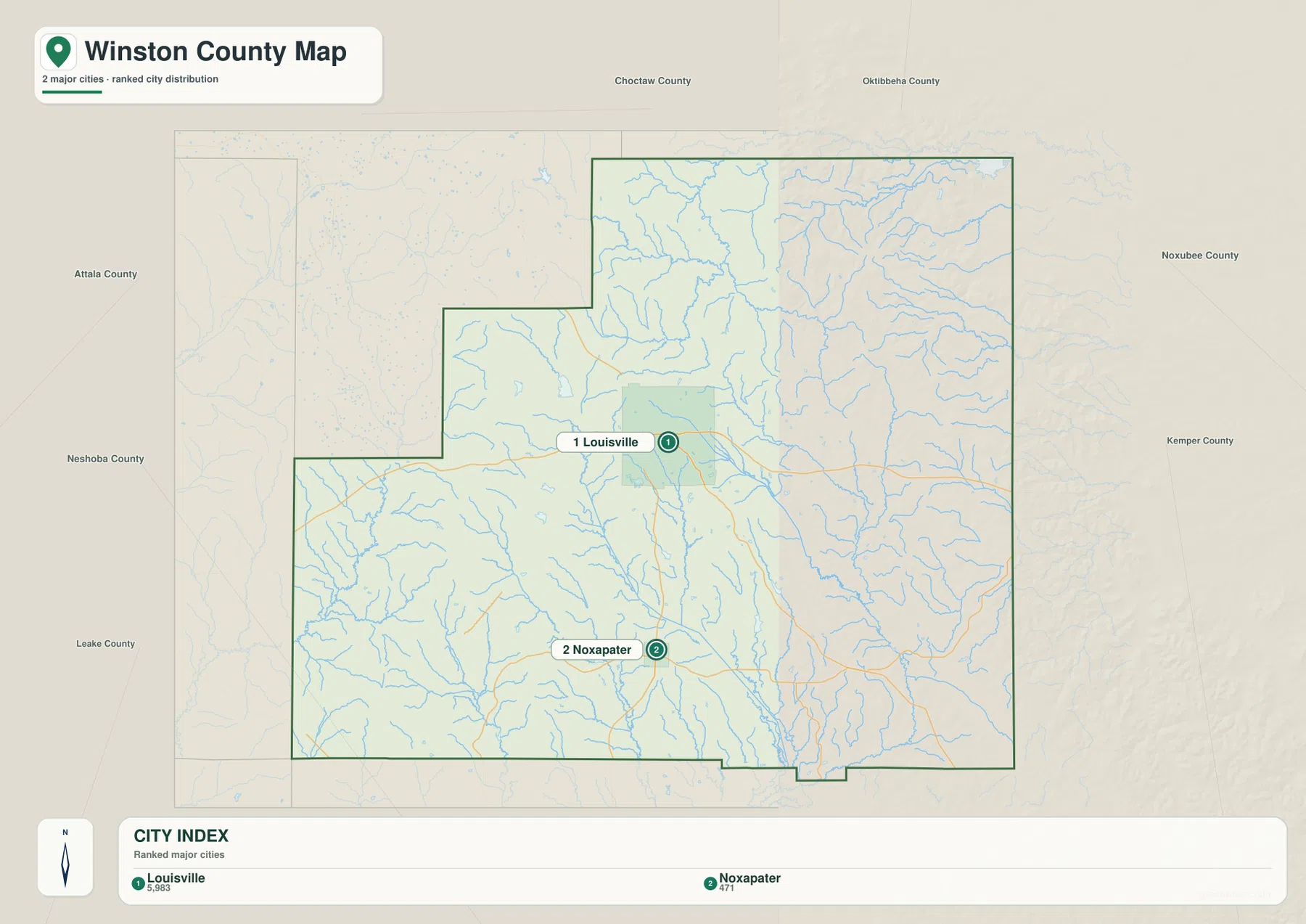
The surrounding county labels add regional context without cluttering the interior. Choctaw County and Oktibbeha County appear along the north, Noxubee and Kemper counties are on the eastern side, and Attala, Neshoba, and Leake are shown to the west and southwest. That arrangement makes it easier to see that a northbound trip from Louisville and an eastbound trip toward Noxubee County leave Winston County in different directions.
The source material lists Louisville as the county seat. Winston County recorded 17,714 residents in the 2020 census, while the July 2025 estimate is 17,473, so the two population figures should not be treated as measurements from the same date. The 2025 Gazetteer gives 607.251 square miles of land and 2.835 square miles of water. Dividing the 2020 census population by that land area produces about 29.2 residents per square mile, a countywide average that does not mean people are evenly distributed between Louisville, Noxapater, forest, farms, and smaller communities.
Noxubee River Headwaters and a Dense Creek Network
The terrain-and-water map reveals much more detail than the general road map. The Noxubee River is labeled in the northwest portion of the county, with the Little Noxubee River extending southward from that system. Farther north and northeast, Jones Creek and Ross Branch Reservoir are labeled. Mill Creek appears near the central-northern area, while Murphy Creek crosses the middle of the county toward the east. Nanih Waiya Creek is one of the most prominent named waterways on the southeastern side.
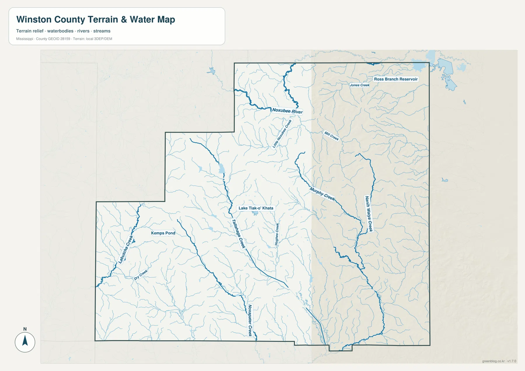
The southern half has its own set of strong references. Tallabogue Creek runs toward the south, Noxapater Creek is labeled near the lower edge, and Lubbub Creek is visible in the southwest. Kemps Pond appears in the western part of the county, while Lake Tiak-O’Khata is labeled closer to the center. These water bodies are modest in size compared with the overall county, but their names help identify specific parts of a map that otherwise contains hundreds of small unnamed tributaries.
The pattern is more important than any single creek. Narrow tributaries repeatedly branch into larger channels, and many of them occupy the same low corridors that appear on the elevation map. The result is a landscape where water and relief are closely connected. This map should not be read as a flood-risk map, however. It shows the location of waterways and terrain, not flood frequency, predicted depth, water quality, or safe navigation conditions.
Elevation from About 70 to 218 Meters
The elevation map gives Winston County a very different appearance from the road map. Its legend reports an actual elevation range of roughly 70 to 218 meters and a mean of about 141 meters. Brown and tan tones mark higher ridges, while greener areas identify lower terrain. Rather than one continuous highland, the county is broken into many elongated ridges separated by narrow valleys. This repeated ridge-and-valley texture is visible across the west, center, and east.
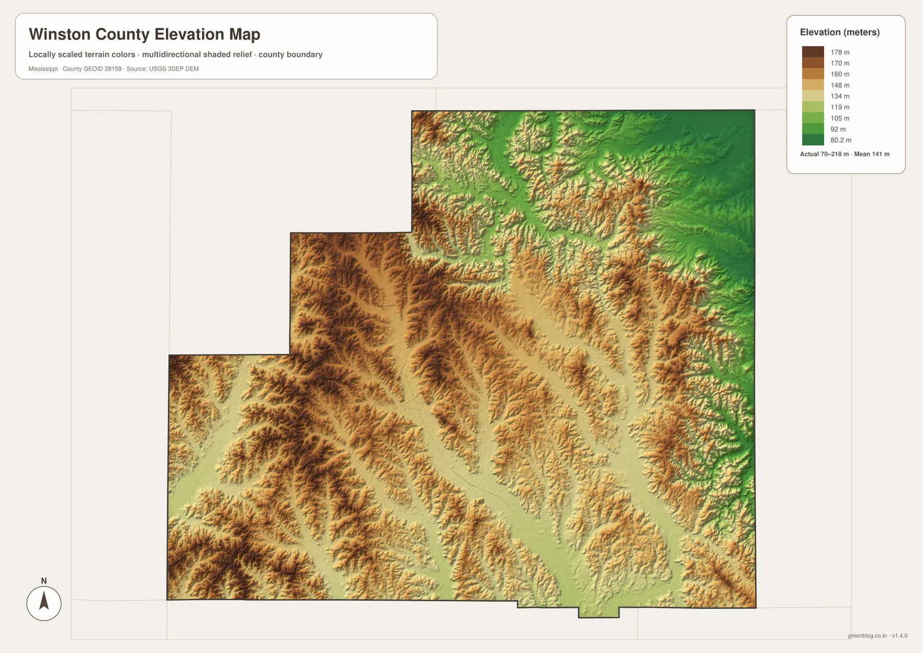
A broad greener zone appears near the northeastern edge, while many of the western and southwestern ridges rise into stronger brown tones. The center and southeast are also dissected by long, narrow valleys. Comparing this surface with the water map explains why streams such as Murphy Creek, Nanih Waiya Creek, and the smaller tributaries follow winding corridors instead of straight lines. They occupy lower parts of a terrain that has been cut into many separate ridges.
The elevation layer is intended for county-scale comparison, not engineering or land surveying. The 70–218 meter range helps explain regional relief, but it cannot provide the precise elevation of a house site, a road grade, or a property corner. Projects that require exact measurements should use original elevation data such as the USGS 3D Elevation Program and, where necessary, professional survey information.
Nanih Waiya as a Geographic and Cultural Reference
Nanih Waiya is useful on a Winston County map because the name appears in the southeastern landscape, including Nanih Waiya Creek, but it also has cultural meaning that should not be reduced to a simple place label. The source package points to information about Nanih Waiya as an important Choctaw mound and cultural landscape. A county map can show where the area lies, yet it does not replace cultural interpretation, visitor guidance, or official information from the relevant Choctaw organization.
The same caution applies to Tombigbee National Forest references in the broader county context. Forested land is extensive, but a county boundary, a national-forest management boundary, and a private property line are three different things. The maps on this page are designed to explain the county’s roads, waterways, communities, and terrain. Anyone who needs exact ownership or management boundaries should consult the appropriate land-management source instead of assuming that wooded terrain on the map is all part of one public holding.
Choosing the Right Winston County Map
Use the county reference map when the first question is where Louisville, Noxapater, and the main state highways are located. The city map is better when you only need to compare the two main labeled places and their position inside the county. For named rivers, creeks, ponds, and reservoirs, the terrain-and-water map contains the most detail. The elevation map is the clearest choice for comparing high ridges with lower valleys. Switching between the maps is usually more useful than trying to force one image to answer every question.
If you need a larger file than the WebP previews, the ZIP below contains the matching high-resolution A3 JPG versions. The archive includes the county map, city map, terrain-and-water map, and elevation map. These files are better suited to printing, classroom materials, slide decks, and image editing. For current driving conditions, property boundaries, flood decisions, or construction measurements, use the maps as orientation material and verify the specific issue with the appropriate official source.
Frequently Asked Questions
How can I quickly distinguish Louisville from Noxapater on the maps?
Louisville is north of the county’s center and is where several major routes converge, including the MS 14 and MS 25 area. Noxapater is farther south and is easy to find near MS 15 and MS 490. The county map is best for the road context, while the city map makes their relative positions especially clear.
Does the water map show which places are at risk of flooding?
No. It shows waterways such as the Noxubee River, Little Noxubee River, Murphy Creek, Nanih Waiya Creek, and many smaller tributaries, but it does not show flood probability or expected water depth. Flood decisions require a dedicated official flood source.
What does the roughly 70–218 meter elevation range represent?
It is the actual countywide range printed on the current elevation preview, which also gives a mean of about 141 meters. The colors and shaded relief make the contrast between ridges and valleys easier to see. They are not a substitute for surveyed elevations at a specific property or construction site.
Sources and Reference Material
- U.S. Census Bureau QuickFacts – Winston County, Mississippi
- U.S. Census Bureau Gazetteer Files
- Mississippi Department of Transportation official highway map
- Nanih Waiya cultural reference
- USGS National Hydrography
- USGS 3D Elevation Program
Map File Information
Download one ZIP containing four high-resolution A3 JPG maps that match the WebP previews on this page.
- File Type: ZIP containing 4 JPG files
Related Maps
Green Map creates custom-edited map images using open geographic data sources such as geoBoundaries, Natural Earth, OpenStreetMap, and government open data. These maps are edited visual materials, not raw data files, and are provided for education, documents, presentations, and graphic reference.