Union County sits on Kentucky’s western edge, where broad Ohio River bends meet an inland network of small cities, rural roads, creeks, and low ridges. This Union County Kentucky Map collection centers on Morganfield and shows Uniontown to the north, Sturgis to the south, Waverly to the east, the Ohio and Tradewater rivers, and terrain ranging from about 99 to 203 meters. High-resolution map files are available for download in the section below.
The page includes a general county map, a city-connections map, a terrain-and-water map, and an elevation map. High-resolution JPG versions can also be downloaded together in a ZIP file. Union County’s official site highlights the county’s agricultural and mining heritage along with outdoor areas such as the Higginson-Henry Wildlife Management Area, while the maps make the physical setting equally clear: wide river bottoms occupy much of the west and north, and more broken uplands rise toward the interior and southeast.
Table of Contents
Morganfield gathers the county’s road network before it spreads in four directions
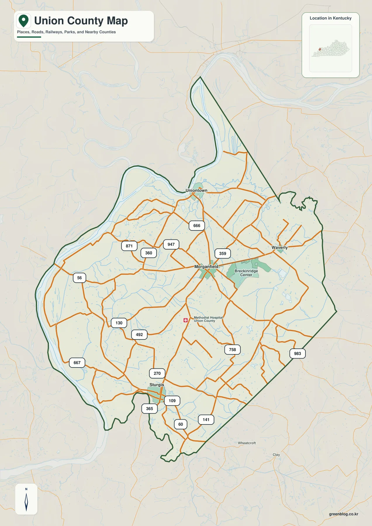
Morganfield is the most useful orientation point on the general county map. It sits near the middle of the county and connects outward toward Uniontown, Sturgis, Waverly, and the river-side roads to the west. Labels such as KY 359, KY 360, KY 666, KY 871, KY 947, KY 758, and KY 983 show a dense local network, while US 60 appears across the southern side near Sturgis along with KY 109, KY 141, KY 365, and KY 270.
Uniontown lies north of Morganfield and much closer to the Ohio River. Sturgis is the strongest southern city marker, positioned near the cluster of US 60 and several state routes. Waverly lies east of Morganfield and is connected by the road corridor around KY 359. Those four places divide the county into easy reference directions, which is much more useful than trying to memorize every secondary road before understanding the broader layout.
The western road pattern changes as it approaches the river bottom. Routes such as KY 56, KY 130, and KY 667 cross areas where the Ohio River’s broad bends and low floodplain dominate the landscape. Around Morganfield and the Breckinridge Center area, roads approach from more directions and the network becomes tighter. The contrast between those two areas is one of the clearest ways to see how settlement and terrain interact in Union County.
The general map is a geographic reference rather than a live navigation service. It does not show current traffic, construction closures, speed limits, or private access conditions. For actual driving, a current road source should be used alongside it. Its strongest use is showing which communities and numbered roads connect across the county and how those routes sit relative to the Ohio River and the county boundary.
A Morganfield hub view makes the four main city positions easy to compare
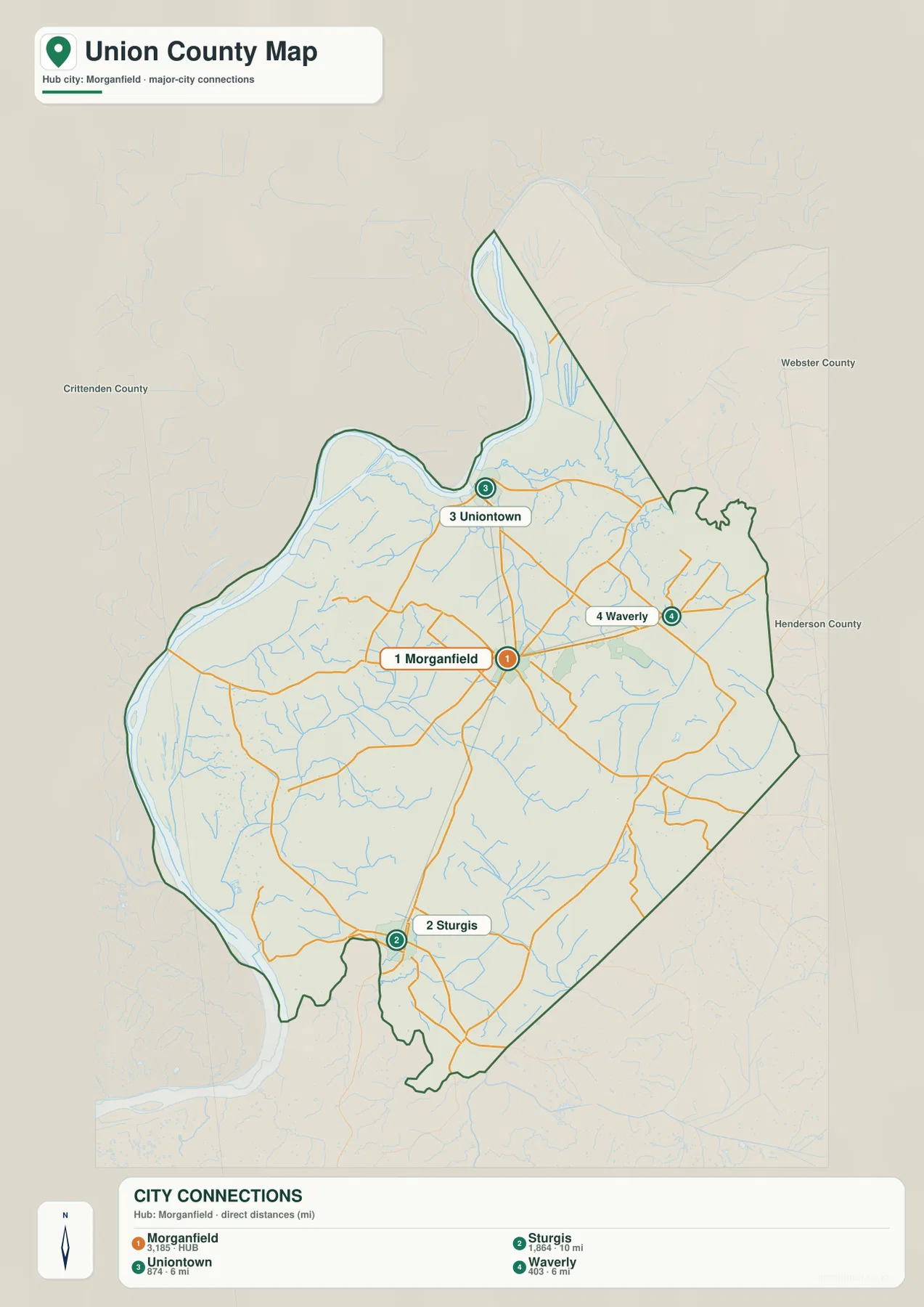
The city-connections map removes most of the detailed route labels and treats Morganfield as the hub. The index places Sturgis about 10 miles away in straight-line distance, while Uniontown and Waverly are each about 6 miles from Morganfield. Those measurements are not driving distances or travel times; they are simple geographic comparisons that help establish the county’s internal scale.
The arrangement is easy to remember. Uniontown is north of Morganfield, Waverly is east, and Sturgis is south. The broad western side contains fewer large city markers because much of that part of the county follows the Ohio River lowland. To the east, Webster and Henderson Counties provide regional context around Waverly, while Crittenden County lies beyond the southern and southwestern side near the Sturgis and Tradewater River area.
Numbers in the city index come from the source snapshot used to build the map and should not be treated as current official population counts. Recent demographic work should use the U.S. Census Bureau or another current official dataset. The value of this file is spatial: it gives a clean picture of the county’s primary city positions without the visual load of every creek, road, and elevation band.
The Ohio River dominates the west while the Tradewater River anchors the south
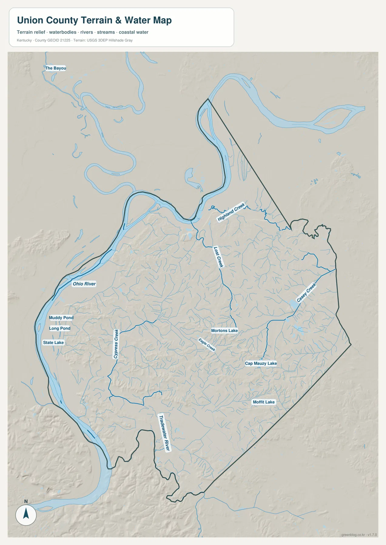
The Ohio River is the strongest natural feature on the map. It follows the county’s northern and western side in large bends, leaving a broad lowland between the main channel and the interior hills. Numerous narrow channels and abandoned-looking river traces appear near the floodplain, giving the west a very different texture from the more dissected country around Morganfield and farther east.
The Tradewater River becomes important toward the southwest and south, where it follows the county edge near the Sturgis side. Inside the county, Cypress Creek and Eagle Creek cut across the southern half, Highland Creek and Lost Creek appear farther north, and Casey Creek runs through the east. Rather than one simple drainage line, Union County contains many small valleys that feed toward larger river systems on different sides.
Several lakes and ponds add smaller water features to the map. Muddy Pond, Long Pond, and State Lake are grouped close to the western river country. Mortons Lake lies farther inland, and Moffit Lake appears in the southeastern half. These water bodies are much smaller than the Ohio River, but their distribution reinforces the contrast between the broad river bottom, the creek-cut interior, and the rolling ground farther east.
The county and Morganfield official pages also point to outdoor resources including the Higginson-Henry Wildlife Management Area and local recreation sites. Those references fit the water-and-terrain setting shown here, but this map is not a flood-risk product, depth chart, navigation guide, fishing regulation map, or legal boundary survey. Questions about flood zones, water levels, boating, or property boundaries require current specialized agency data.
Relief from 99 to 203 meters separates the river bottoms from the southeastern hills
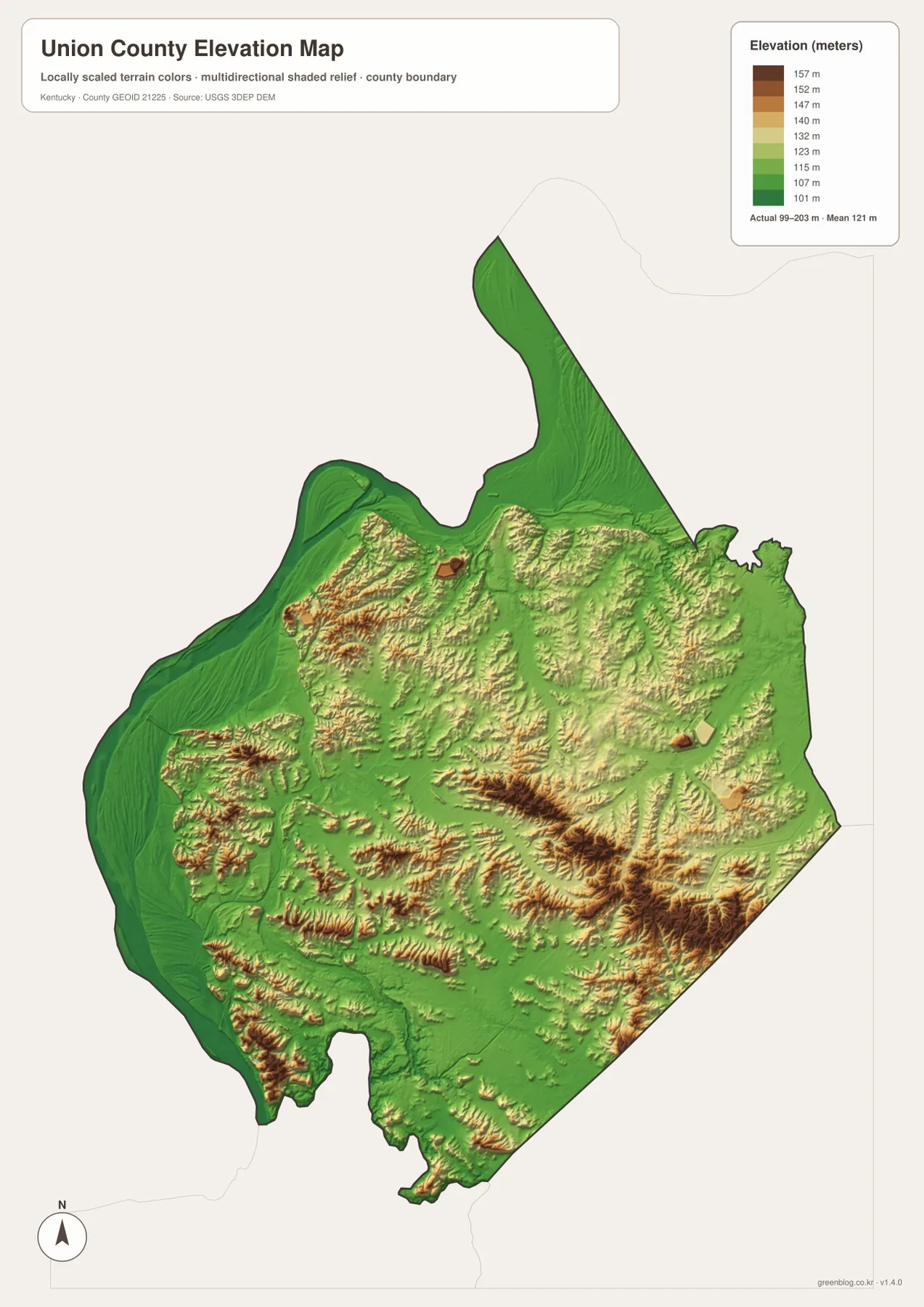
The elevation legend reports an actual county range of about 99 to 203 meters, with a mean near 121 meters. Dark green marks the lowest ground, while yellow, orange, and brown shades identify progressively higher terrain. The widest low zone follows the Ohio River around the west and north, where the landscape is noticeably flatter than the interior.
Central and eastern Union County are more broken. Narrow ridges rise between creek valleys, and the color pattern becomes especially complex toward the southeast. Casey Creek and Eagle Creek follow lower corridors through this higher ground. Instead of one dominant mountain or plateau, the county contains many smaller ridges separated by streams, which matches the branching road pattern visible on the general map.
The western half is not uniformly flat. Away from the main Ohio River bottom, short ridges rise between drainage lines, particularly toward the middle of the county. The difference is still clear, however: the broad river-side green zone occupies much larger continuous areas than the warmer colors of the interior. Around Sturgis and the southern boundary, small hills and creek valleys create a transition between the low western river country and the more dissected southeastern side.
The 99–203 meter range is appropriate for county-scale comparison, not site surveying. It should not be used to set a building elevation, bridge height, mining grade, or drainage design. Engineering and property-level work should use the underlying USGS 3D Elevation Program data at a suitable resolution and, where needed, professional field survey measurements.
Three cross-county comparisons reveal why the maps fit together
One useful comparison starts at Uniontown. The road map places the city north of Morganfield, the city map shows it roughly 6 miles away in straight-line distance, and the water map explains its proximity to the Ohio River. On the elevation map, that same northern area belongs to the broad low green zone. A single place therefore connects the county’s settlement pattern directly to its largest river and lowest terrain.
A second comparison runs from Morganfield south toward Sturgis. The general map emphasizes the road connections and the US 60 corridor near Sturgis, while the water map adds smaller creeks and the Tradewater River setting. The elevation map shows more frequent ridges and valleys than the Ohio River floodplain. That progression helps explain why the southern road network looks more irregular even though the distance between the two cities is not especially large.
Waverly and the eastern side provide a third example. The city map shows Waverly only about 6 miles from Morganfield, but the terrain files reveal that the east is not simply flat open country. Casey Creek and numerous small tributaries cut through rolling ground, and higher ridges appear between them. Comparing those layers makes the county feel much more varied than the simple city distances would suggest.
Selecting the Union County file that matches the question
The general county map is the strongest starting point when communities, roads, and the county outline need to be visible together. The city-connections map is simpler for comparing Morganfield with Uniontown, Sturgis, and Waverly. The terrain-and-water file is better for the Ohio River, Tradewater River, and named creeks, while the elevation map makes the broad river bottoms and higher interior ridges easy to distinguish.
- County map: Use it for Morganfield, Uniontown, Sturgis, Waverly, KY 359, KY 360, KY 666, KY 871, KY 947, KY 758, US 60, and the county boundary.
- City map: Use it to compare the Morganfield hub with Sturgis at about 10 miles and Uniontown or Waverly at about 6 miles in straight-line distance.
- Terrain and water map: Use it for the Ohio River, Tradewater River, Highland Creek, Lost Creek, Casey Creek, Cypress Creek, Eagle Creek, and the labeled lakes and ponds.
- Elevation map: Use it to compare the approximately 99–203 meter relief, especially the low western river bottom and the higher central and southeastern ridges.
Each original JPG is 2572 × 3638 pixels in portrait orientation, preserving more small road and water labels than the web previews. Keeping the original aspect ratio is recommended for printing. When using several files together, start with Morganfield and the city connections, move to the river and creek network, and finish with elevation so the same locations can be followed across each theme.
Frequently Asked Questions
Which map best compares Morganfield with Uniontown, Sturgis, and Waverly?
The city-connections map gives the clearest quick comparison. It uses Morganfield as the hub and shows Sturgis at about 10 miles in straight-line distance, with Uniontown and Waverly each about 6 miles away. For actual routes and numbered highways, use the general county map instead.
Where can I see the Ohio River, Tradewater River, and Union County creeks together?
The terrain-and-water map shows the Ohio River and Tradewater River along with Highland Creek, Lost Creek, Casey Creek, Cypress Creek, Eagle Creek, and several named lakes and ponds. It is a geographic reference, not a flood, navigation, depth, or legal-boundary map.
Can the 99–203 meter elevation map be used for surveying?
No. The elevation file is intended for county-scale comparison of the low Ohio River bottom and the higher interior ridges. The approximately 99–203 meter range and 121 meter mean are useful for regional terrain description, but construction, engineering, drainage, mining, or parcel-level work requires more precise source data and appropriate field measurements.
Map File Information
The ZIP contains high-resolution JPG versions of the Union County general map, city map, terrain-and-water map, and elevation map. Use the previews to check Morganfield, Uniontown, Sturgis, Waverly, the main roads, the Ohio and Tradewater rivers, and the 99–203 meter relief before selecting the original files.
- Included Files: Use only the versions confirmed in the article and supplied images
- File Type: Use the confirmed download contents
- Intended Use: Printing, education, presentations, and map-based projects
Related Maps
Sources and references
The geographic discussion is based primarily on the supplied Union County maps, with official county, city, boundary, hydrography, and elevation sources used for context.
- Union County official county profile — county history, outdoor resources, and local context.
- City of Morganfield — official city information and local recreation context.
- U.S. Census Bureau TIGER/Line Shapefiles — official geographic boundary and road data.
- USGS National Hydrography — federal hydrography background for rivers, creeks, and water features.
- USGS 3D Elevation Program — federal elevation and terrain data program.
Green Map creates custom-edited map images using open geographic data sources such as geoBoundaries, Natural Earth, OpenStreetMap, and government open data. These maps are edited visual materials, not raw data files, and are provided for education, documents, presentations, and graphic reference.