Wolfe County sits in eastern Kentucky, where Campton anchors the road network and closely spaced ridges are cut by the Red River and a dense set of mountain creeks. This Wolfe County Map collection shows Campton, Hazel Green, Burkhart, KY 15, KY 191, KY 205, the Red River drainage, and an elevation range of about 198 to 440 meters. High-resolution map files are available for download in the section below.
The web previews make it easy to check roads, settlement locations, water features, and relief before downloading the original high-resolution JPG files in a ZIP. Wolfe County is compact, but its terrain changes quickly because narrow valleys separate short ridges across almost the entire county. Campton provides the simplest reference point for comparing the western Red River side with the longer eastern half.
Table of Contents
Campton ties KY 15 and KY 191 to a winding network of mountain roads
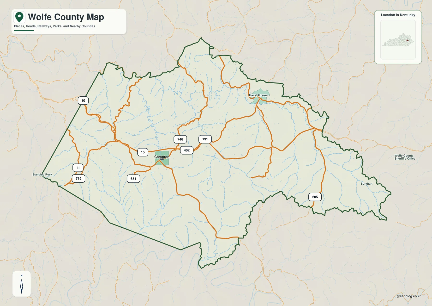
Campton is the clearest place to begin reading the road map. KY 15 passes through the town and provides the main east–west reference, while KY 191 runs northeast from the Campton area. KY 402, KY 746, and KY 651 are also labeled nearby, giving the central part of the county a denser road pattern than the outer mountain valleys.
Hazel Green is a useful northeastern reference along the KY 191 side, while Burkhart sits near the long eastern tip of the county close to KY 205. On the west, KY 11, KY 715, and KY 10 approach the boundary near Standing Rock. Those routes are noticeably more winding than a typical lowland road grid because the valleys provide the practical paths through the ridges.
The long east–west shape of Wolfe County becomes clearer when Campton, Hazel Green, and Burkhart are compared together. Campton is not at the exact center of the outline, so the eastern half extends much farther beyond the main town than a quick glance at the city marker might suggest. The road map is designed for geographic orientation rather than current traffic, construction, speed limits, or private access conditions.
Campton stands alone as the main city reference inside the county
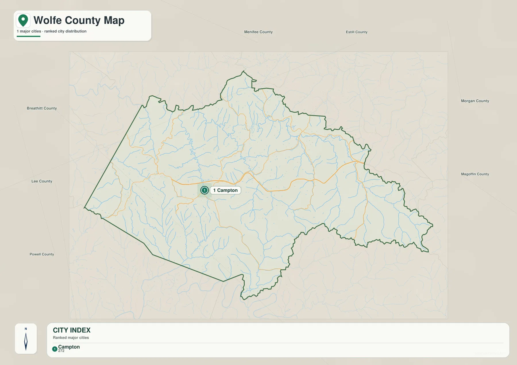
The city map removes most route labels and highlights Campton as the single major-city reference. The town lies a little west of the county’s visual center, leaving a long stretch of ridge-and-valley country to the east. That simple placement makes Campton a useful anchor before moving into the more detailed road, water, and elevation maps.
Menifee and Estill Counties are shown to the north, Morgan and Magoffin Counties lie to the east, Breathitt County is southeast, and Lee and Powell Counties are to the west. Kentucky Department for Local Government records also place Wolfe County’s government address in Campton, reinforcing the town’s role as the county’s administrative reference.
The population figure printed in the city index belongs to the source snapshot used for the map and should not be treated as a current official total. Recent demographic work should use the U.S. Census Bureau. The useful part of this file is the relationship between Campton, the county outline, and the neighboring counties.
Red River, Swift Camp Creek, and smaller streams occupy the low valleys
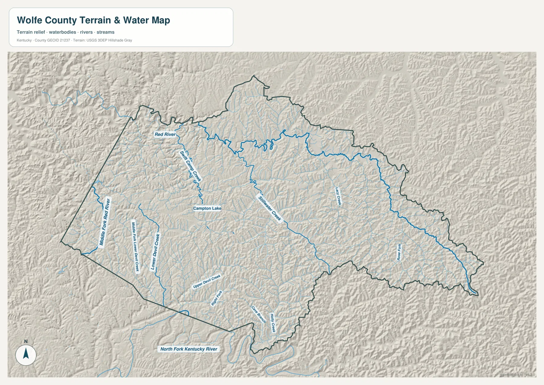
The Red River is the most prominent named water feature on the northwestern side. Swift Camp Creek approaches from the south, and Campton Lake sits near that drainage. Farther west, Middle Fork Red River follows a separate low corridor close to the county boundary, giving the western side more than one major valley reference.
Stillwater Creek runs through the central interior toward the north, while Lacy Creek is labeled farther east. Lower Devil Creek and Upper Devil Creek occupy long southwestern valleys. Together, these waterways show why the county surface looks so deeply divided: streams use the low gaps between ridges, and those same valleys often guide local roads.
Rose Fork is marked in the southeast, while Right Fork, Cave Branch, and Holly Creek appear in the southern interior. The North Fork Kentucky River is labeled just outside the southern boundary, providing a larger downstream reference for the surrounding drainage. Comparing the water and elevation files shows a close match between blue stream lines and green lowlands.
This file is intended to show relative water locations, not flood risk, water depth, navigation, legal shoreline boundaries, or parcel ownership. Current specialized agency data should be used for those purposes.
Relief from 198 to 440 meters forms a dense pattern of ridges and creek valleys
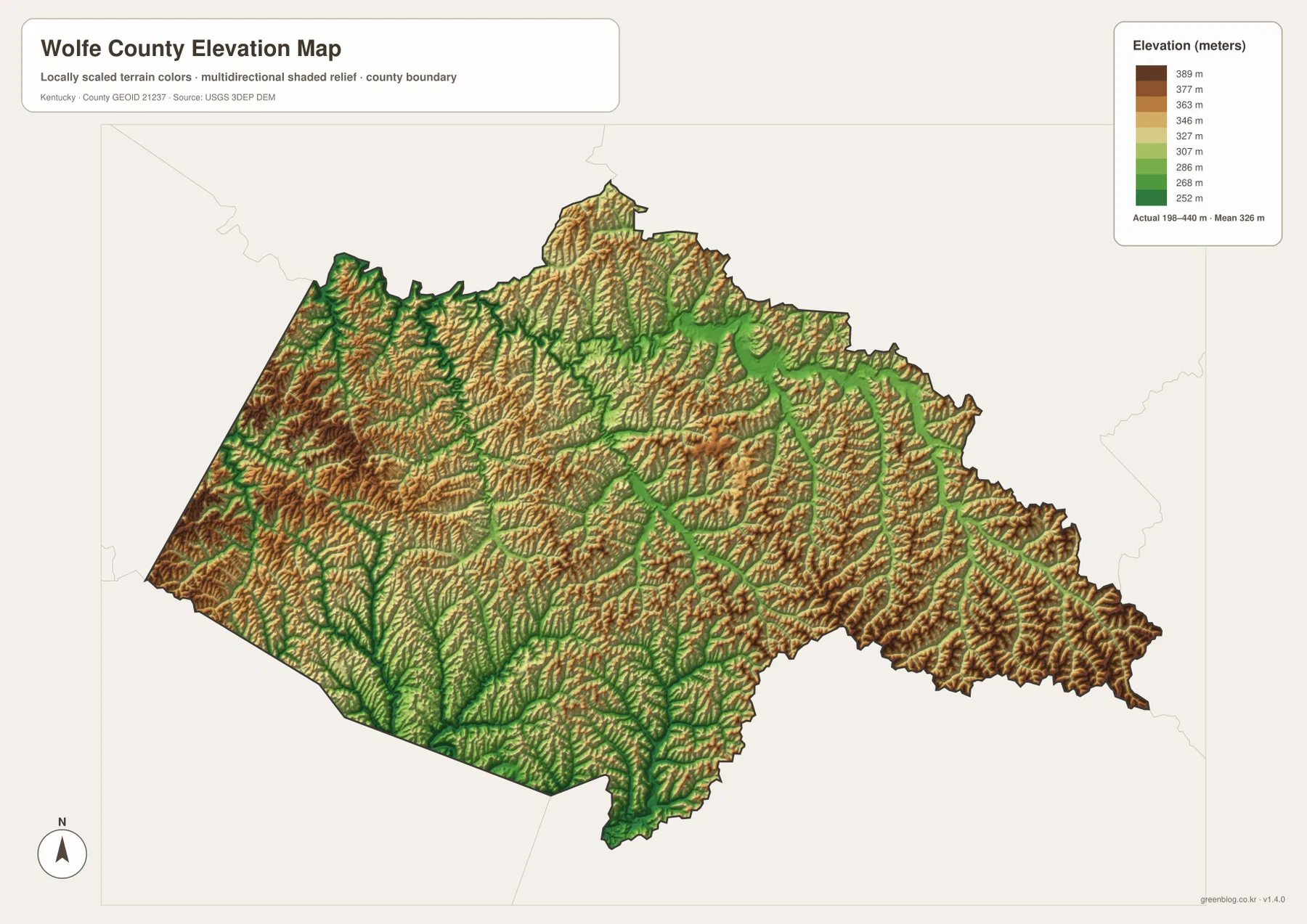
The elevation legend reports an actual county range of about 198 to 440 meters, with a mean near 326 meters. Green marks lower ground, while yellow, orange, and brown represent progressively higher ridges. The western and northwestern side contains many compact ridge groups, with the Red River and Middle Fork Red River cutting lower corridors between them.
Campton sits near a lower central valley, but higher ground rises quickly around it. Stillwater Creek and Lacy Creek can be followed as elongated green corridors, while the ridges between them turn yellow and brown. The county does not have one dominant summit or one broad plateau; instead, short ridges repeat almost continuously across the landscape.
The eastern tip continues the same pattern, with narrow stream valleys separated by elevated ridges. Lower Devil Creek and Upper Devil Creek create deep-looking green branches in the southwest, while Rose Fork marks another low corridor toward the southeast. This repeated ridge-and-valley structure explains why roads often change direction even when two places are relatively close in straight-line distance.
The 198–440 meter range is suitable for county-scale terrain comparison, not survey or engineering work. Building elevations, bridge grades, drainage calculations, and parcel-level measurements require higher-resolution USGS elevation data and, when necessary, professional field surveying.
Three directions from Campton show how the county changes over short distances
Northwest from Campton, KY 15 and nearby routes approach the Red River, Swift Camp Creek, and Campton Lake. The water map shows broad low corridors in that direction, while the elevation map places ridges immediately beside them. This is the easiest part of the county for seeing the connection between river valleys and the surrounding high ground.
Northeast toward Hazel Green, KY 191 provides the strongest road reference. Stillwater Creek and numerous short tributaries occupy the valleys around the route, and elevation changes repeatedly from green lows to higher brown ridges. East toward Burkhart, KY 205 and the Lacy Creek–Rose Fork side provide a second comparison across the county’s long eastern extension.
The southwest has a different set of valley references, especially Lower Devil Creek and Upper Devil Creek. Roads and streams both turn repeatedly through the ridges, making this side of Wolfe County feel more enclosed than the central Campton area. Comparing those three directions shows how much geographic variety fits inside a relatively small county.
Choose the Wolfe County file that matches the detail you need
The general county map is the best starting point for Campton, road numbers, and local place names. The city map is cleaner when Campton and neighboring counties are the main concern. The terrain-and-water file is strongest for the Red River and tributary network, while the elevation map makes the 198–440 meter relief easiest to compare.
- County map: Use it for Campton, Hazel Green, Burkhart, KY 15, KY 191, KY 205, KY 715, KY 11, KY 10, KY 402, KY 746, and KY 651.
- City map: Use it to place Campton relative to Menifee, Estill, Morgan, Magoffin, Breathitt, Lee, and Powell Counties.
- Terrain and water map: Use it for Red River, Middle Fork Red River, Swift Camp Creek, Stillwater Creek, Lacy Creek, Lower Devil Creek, Rose Fork, and Campton Lake.
- Elevation map: Use it to compare the approximately 198–440 meter range and the close relationship between low creek valleys and higher ridges.
Each original JPG measures 3638 × 2572 pixels in landscape orientation, preserving more small road and creek labels than the web previews. Keeping the original aspect ratio is recommended for printing.
Frequently Asked Questions
Which map is best for Campton, KY 15, and KY 191?
The general county map is the best choice because it combines Campton with KY 15, KY 191, KY 402, KY 746, KY 651, western routes such as KY 715 and KY 11, and KY 205 on the eastern side.
Where can I see Red River and Swift Camp Creek most clearly?
The terrain-and-water map shows Red River, Middle Fork Red River, Swift Camp Creek, Stillwater Creek, Lacy Creek, Lower Devil Creek, Rose Fork, Campton Lake, and many smaller tributaries. It is a geographic reference rather than a flood, depth, navigation, or legal-boundary map.
What stands out on the 198–440 meter elevation map?
Short ridges are packed closely around the county’s creek valleys. The mean elevation is about 326 meters, and the Red River, Stillwater Creek, Lacy Creek, and Devil Creek valleys appear as lower corridors between higher ground. The file is useful for regional comparison but not for construction or surveying.
Map File Information
The ZIP contains high-resolution JPG versions of the Wolfe County general map, city map, terrain-and-water map, and elevation map. Use the previews to check Campton, the main roads, Red River tributaries, Campton Lake, and the 198–440 meter relief before opening the original files.
- Included Files: Use only the versions confirmed in the article and supplied images
- File Type: Use the confirmed download contents
- Intended Use: Printing, education, presentations, and map-based projects
Related Maps
Sources and references
The geographic discussion is based primarily on the supplied Wolfe County maps, with Kentucky local-government records and federal boundary, hydrography, and elevation sources used for context.
- Kentucky Department for Local Government – Wolfe County — official county and Campton local-government information.
- Kentucky Department for Local Government – City of Campton — official Campton city record.
- U.S. Census Bureau TIGER/Line Shapefiles — official geographic boundary and road data.
- USGS National Hydrography — federal hydrography background for rivers, creeks, and water features.
- USGS 3D Elevation Program — federal elevation and terrain data program.
Green Map creates custom-edited map images using open geographic data sources such as geoBoundaries, Natural Earth, OpenStreetMap, and government open data. These maps are edited visual materials, not raw data files, and are provided for education, documents, presentations, and graphic reference.