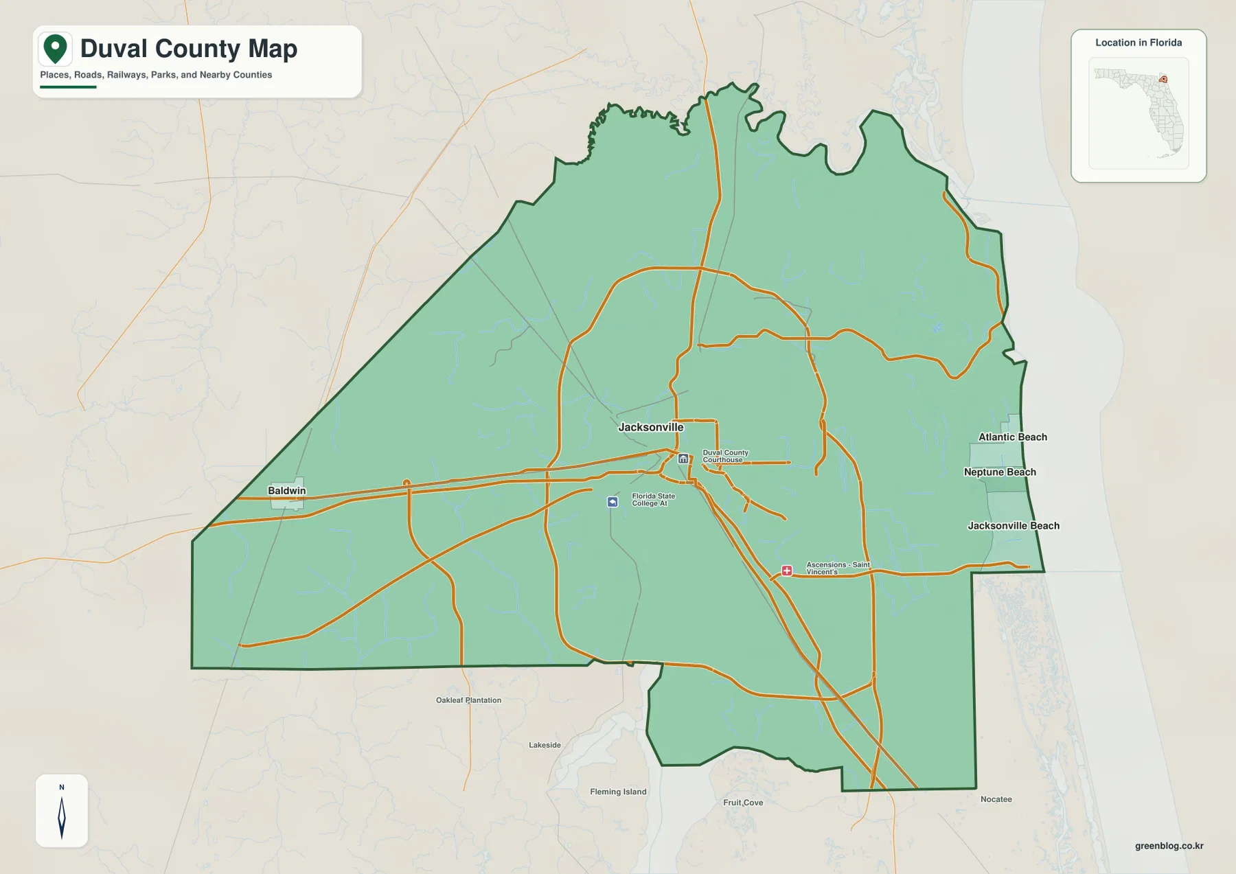
The Duval County Florida Map makes the most sense when Jacksonville is viewed together with the St. Johns River, the three Atlantic beach cities, and Baldwin on the far west side. Jacksonville covers most of the county under the consolidated city-county government, but Atlantic Beach, Neptune Beach, Jacksonville Beach, and Baldwin remain separate municipalities. Downtown is organized around the St. Johns River and the I-95/I-10 road network, while I-295 loops through a much larger suburban area. This page uses only the three maps supplied in the package: the county reference map, the city map, and the terrain-and-water map. Download the high-resolution A3 JPG map ZIP from the file box below when you need the full-size versions of all three maps.
Table of Contents
The St. Johns River Bend Is the Best Natural Reference for Jacksonville
Jacksonville is shown near the center of the county, where the St. Johns River creates one of the map’s most recognizable shapes. The river approaches from the south, continues north through the urban area, and then bends east toward the Atlantic. That change in direction explains why the same river appears as both a north-south waterway and an east-west estuary within Duval County.
The road pattern adds a second orientation system. I-95 runs north-south through Jacksonville, and I-10 arrives from the west and ends at I-95 west of downtown. I-295 forms a much wider loop around the central city and crosses the St. Johns River on the outer sides of the metro area. On the western edge, Baldwin is better located with US 90 and US 301 than with the downtown interstate network.
The county map also labels major local facilities, including Florida State College at Jacksonville and Ascension St. Vincent’s. These markers help indicate where the developed core lies, but the map is intended for county-scale orientation rather than street-level navigation or live traffic.
Jacksonville and Duval County Mostly Overlap, but They Are Not Identical
The City of Jacksonville material included in the package explains that Jacksonville and Duval County governments consolidated in 1968. That is why Jacksonville occupies most of the county on many maps and why the city and county are often discussed together. The consolidation did not eliminate every municipality inside the county, however.
Atlantic Beach, Neptune Beach, Jacksonville Beach, and Baldwin remain separate municipalities. This distinction matters especially on the Atlantic side. The three beach cities sit close together along the coast, but they are not simply Jacksonville neighborhoods for municipal purposes. The Intracoastal Waterway, marshes, and tidal channels also create a visible geographic separation between the beach strip and much of inland Jacksonville.
Baldwin provides the western counterpart. It is shown near the county edge rather than as part of the central Jacksonville cluster. Reading the map with this administrative structure in mind prevents a common mistake: assuming that every point inside the Duval County boundary belongs to the same municipal government.
The City Map Compares Jacksonville with the Beach Cities and Baldwin
The city map ranks five major municipal places. Its CITY INDEX lists Jacksonville at 977,670, Jacksonville Beach at 23,654, Atlantic Beach at 13,363, Neptune Beach at 7,168, and Baldwin at 1,298. These values are printed directly on the supplied map and are most useful for understanding the large scale difference between Jacksonville and the four smaller municipalities.
The location pattern is just as informative as the numbers. Jacksonville occupies the central and inland side, while Atlantic Beach, Neptune Beach, and Jacksonville Beach line up close together along the Atlantic coast. Baldwin sits alone near the western edge. This creates three distinct municipal settings: the huge consolidated Jacksonville area, a compact Atlantic beach group, and a small inland town far to the west.
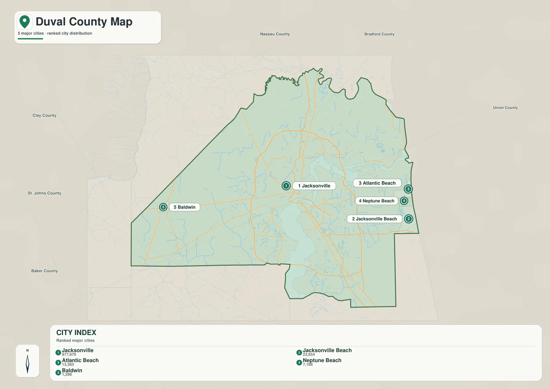
The surrounding county labels—Nassau, Baker, Clay, and St. Johns—add regional context. Baldwin lies toward the Baker County side, while the beach municipalities occupy the Atlantic edge. The city map is therefore useful when a county profile needs municipal relationships without the full detail of roads, port areas, tributaries, and wetlands.
The St. Johns Estuary Links Downtown, Port Areas, and the Northeast Marshes
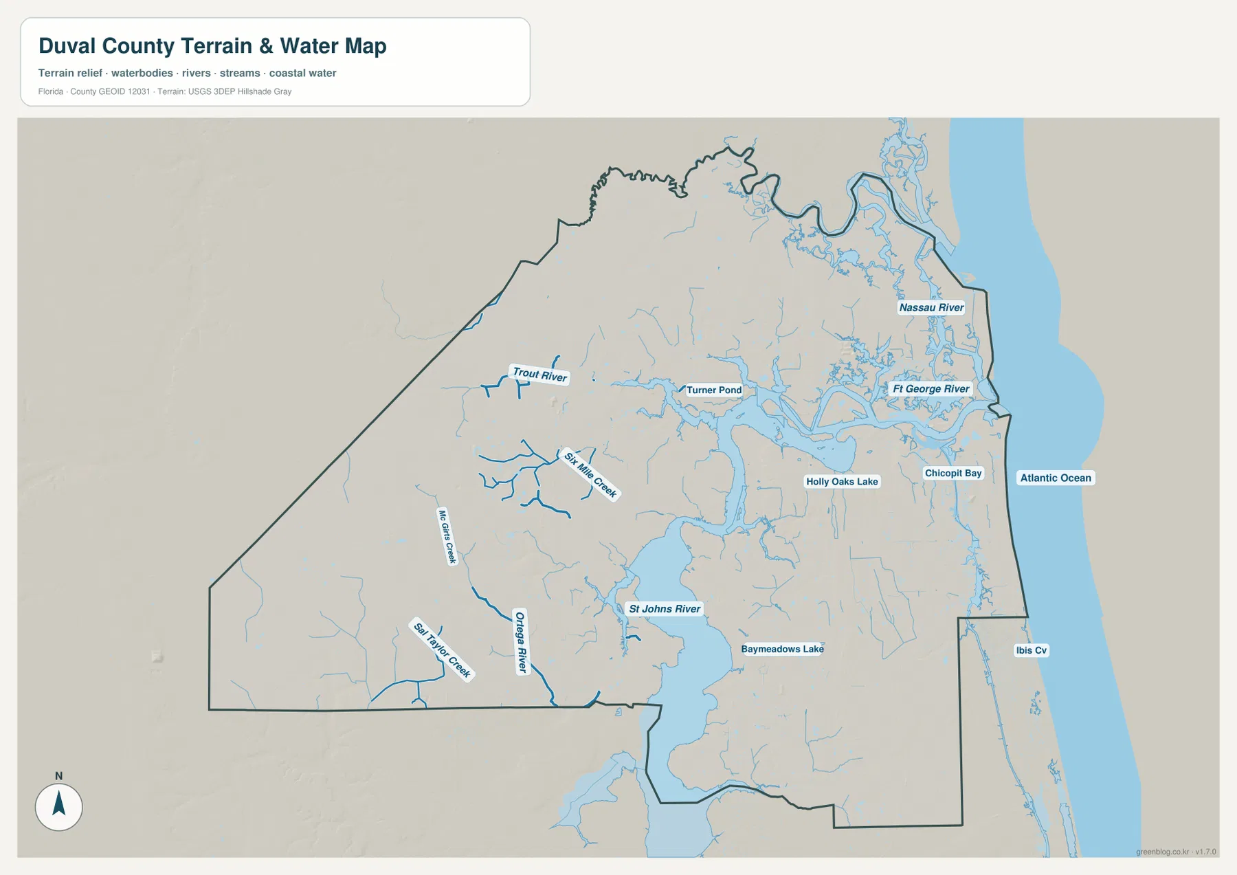
The terrain-and-water map gives the St. Johns River the strongest visual weight. The river enters from the south, widens through the Jacksonville area, and turns toward the Atlantic. The St. Johns River Water Management District source included with the package describes the river as a major north-flowing Florida river, with the lower Jacksonville reach influenced by tides as it approaches the sea.
Farther northeast, the map labels the Nassau River, Fort George River, and Chicopit Bay. This is a much more water-dominated landscape than central Jacksonville. The National Park Service source for Timucuan Preserve provides the supplied context for the broad estuary, salt-marsh, island, and tidal-channel environment near the river mouth and north side of the county.
JAXPORT information supplied in the package also helps explain the geography. Port facilities are distributed along the lower St. Johns River rather than concentrated at one downtown point. Following the river northeast from the central city is therefore a useful way to understand how Jacksonville’s urban core, shipping channel, port terminals, and Atlantic outlet fit into one continuous water corridor.
Trout River and Ortega River Show the County’s Smaller Drainage Systems
The water map includes many named waterways beyond the St. Johns. Trout River appears in the northwest, with Six Mile Creek nearby. McGirts Creek and Big Taylor Creek are labeled farther west and southwest, while the Ortega River runs toward the St. Johns from the southwest side. These waterways make it clear that Jacksonville’s inland area is divided by more creeks and wet lowlands than a highway-only map suggests.
The eastern half also contains smaller named water features such as Holly Oaks Lake, Baymeadows Lake, and Ibis Cove. They are not the main orientation landmarks for the county, but they help show how lakes, creeks, tidal areas, and developed neighborhoods are interwoven across the metro area.
The Atlantic Beaches and Baldwin Represent Opposite Edges of the County
Atlantic Beach, Neptune Beach, and Jacksonville Beach form a short coastal chain along the Atlantic. Baldwin is nearly the opposite kind of place: a small inland town at the western edge, oriented toward US 90 and US 301 rather than the beach and Intracoastal Waterway. Seeing both sides on the same county map shows how geographically broad Duval County is despite its strong association with Jacksonville.
This contrast also helps with map selection. The county map is the strongest single choice for downtown, highways, beaches, Baldwin, and county boundaries. The city map is cleaner for comparing municipalities. The water map is better for the St. Johns estuary, the northeast marshes, and inland tributaries. Selecting the map that matches the question usually produces a clearer handout or presentation.
Use These Maps for Orientation, Not Flood, Survey, or Navigation Decisions
No elevation map is included in this package, so exact elevations or contour lines should not be inferred from these files. The water map is not a flood-zone, parcel-boundary, or marine-navigation chart, and the road map does not provide live traffic or construction information. Within those limits, the supplied maps work well for county overviews, classroom material, travel orientation, and documents that need a clear visual reference for municipalities, highways, rivers, and the Atlantic coast.
For printing or larger documents, use the ZIP below rather than relying only on the smaller web previews. The archive contains three A3 high-resolution JPG files corresponding to the county, city, and terrain-and-water maps shown on this page. Each JPG can be used separately, so a project can include only the map that fits the task.
Frequently Asked Questions
Are Jacksonville and Duval County boundaries exactly the same?
Not exactly. Jacksonville and Duval County consolidated their governments in 1968, so Jacksonville covers most of the county, but Atlantic Beach, Neptune Beach, Jacksonville Beach, and Baldwin remain separate municipalities.
Why does the St. Johns River appear to run both north and east on the map?
The river flows north through much of Florida and then bends east in the Jacksonville area before reaching the Atlantic. Duval County therefore contains both a broad north-south river reach and an east-west estuary.
Are Atlantic Beach, Neptune Beach, and Jacksonville Beach inside Duval County?
Yes. All three are inside Duval County, but they maintain separate municipal governments. Their coastal location east of the Intracoastal Waterway also makes them appear distinct from inland Jacksonville on a county map.
Map File Information
Download one ZIP containing the three A3 high-resolution JPG files that match the county map, city map, and terrain-and-water map shown on this page.
- Included Files: County map, city map, and terrain-and-water map JPGs
- File Type: ZIP containing 3 JPG files
Related Maps
- Arcadia Roads and Peace River | DeSoto County Florida Map
- Baker County Florida Map
- Blountstown, SR 20, and the Apalachicola River | Calhoun County Florida Map
Sources
- U.S. Census Bureau QuickFacts — Duval County — county population and basic data reference
- City of Jacksonville — consolidated government overview — Jacksonville and Duval County government relationship
- St. Johns River Water Management District — St. Johns River — river and estuary reference
- JAXPORT — cargo terminal locations — lower St. Johns River port geography
- National Park Service — Timucuan Preserve — northeast estuary and marsh landscape
Green Map creates custom-edited map images using open geographic data sources such as geoBoundaries, Natural Earth, OpenStreetMap, and government open data. These maps are edited visual materials, not raw data files, and are provided for education, documents, presentations, and graphic reference.