Itasca County stretches from the Grand Rapids area in the south into a much more sparsely settled northern landscape filled with lakes, rivers, and forest. Grand Rapids, Cohasset, Coleraine, and Bovey sit close together in the south-central part of the county, while Keewatin and Nashwauk continue east and Deer River lies to the west. Farther north, Bigfork and Effie are separated by long distances and a dense field of water features.
This page uses the supplied county, city, water, and elevation maps to explain those differences with the actual place names shown in the package. The original high-resolution JPG files are also available together in one ZIP download for printing, classroom projects, presentations, or image editing.
Table of Contents
Grand Rapids anchors the southern road and settlement pattern
Grand Rapids is the easiest reference point on the general county map. Cohasset lies immediately to the west, while Coleraine and Bovey sit to the east. Taconite and Marble continue that eastward sequence, followed by Nashwauk and Keewatin closer to the county’s eastern side. The concentration of named communities makes the southern part of Itasca County look very different from the lightly settled north.
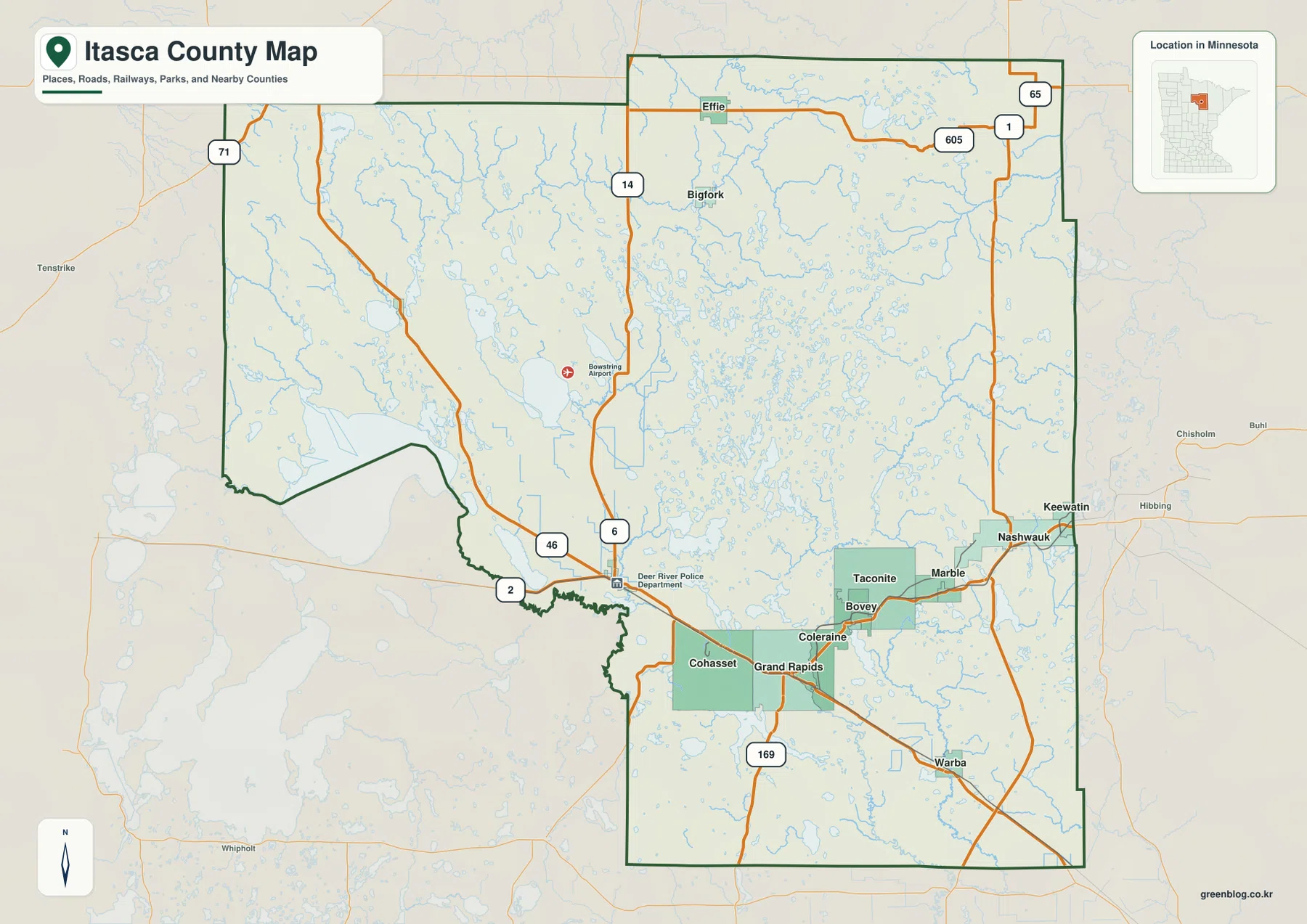
Routes 2 and 169 are especially useful for orienting the southern map. Route 169 approaches Grand Rapids from the south, while Route 2 connects the Deer River side with Grand Rapids and the communities farther east. Route 6 runs north from the Deer River area, and Route 46 is also visible to the west. These roads provide a practical framework for understanding the populated southern and western parts of the county.
The road pattern thins quickly toward the north. Bigfork sits in the northern interior, Effie is close to the top of the county, and Routes 1 and 65 appear across the northeastern side. Instead of a continuous chain of cities, the northern half contains long stretches where roads and place names are separated by lakes and streams. That contrast is one of the most obvious characteristics of the county map.
Outside labels add useful regional context. Hibbing and Chisholm appear to the east, while Tenstrike is shown to the west. Neighboring county names place Itasca County between St. Louis County and the broader Cass, Beltrami, and Koochiching County region. The map is a geographic overview rather than a live traffic service, so current construction, closures, and winter road conditions should be checked separately.
Six major cities concentrated across the southern third
The city map highlights Grand Rapids, Cohasset, Coleraine, Keewatin, Nashwauk, and Deer River. Grand Rapids is the central southern anchor, Cohasset sits just to its west, and Coleraine lies to the east. Keewatin and Nashwauk are farther east, while Deer River stands apart to the west. Together, the six markers form a broad east-west band across the southern portion of Itasca County.
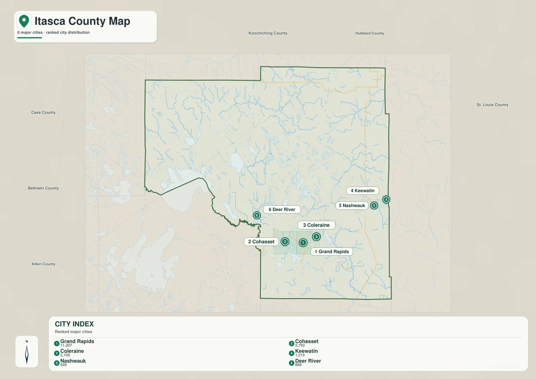
The CITY INDEX printed on the supplied map lists Grand Rapids at 11,207, Cohasset at 2,703, Coleraine at 2,150, Keewatin at 1,215, Nashwauk at 926, and Deer River at 889. These should be treated as the values embedded in the map rather than as a statement of the latest official population estimates. Their most useful message is comparative: Grand Rapids is represented as much larger than the other five selected communities.
Location is just as important as rank. Cohasset and Grand Rapids are close together, Coleraine provides an eastern reference, and Nashwauk and Keewatin extend the populated band toward the St. Louis County side. Deer River gives the west a separate town center. Bigfork and Effie do not appear in the six-city ranking, which reinforces how much of the county’s larger settlement is concentrated in the south.
This simplified city map is not a driving-distance chart. The visual gap between Grand Rapids and Deer River or Nashwauk does not account for road geometry, river crossings, or actual travel routes. Use the city view for quick orientation, then return to the general map or a current navigation service when road mileage matters.
The Mississippi River shapes the southern part of the county
The Mississippi River is the dominant named waterway in southern Itasca County. It crosses the lower part of the county near the Grand Rapids-Cohasset area and continues eastward through a landscape filled with smaller lakes and channels. Comparing the water map with the city view makes it clear that the county’s main urban cluster sits close to a major river corridor rather than on isolated dry ground.
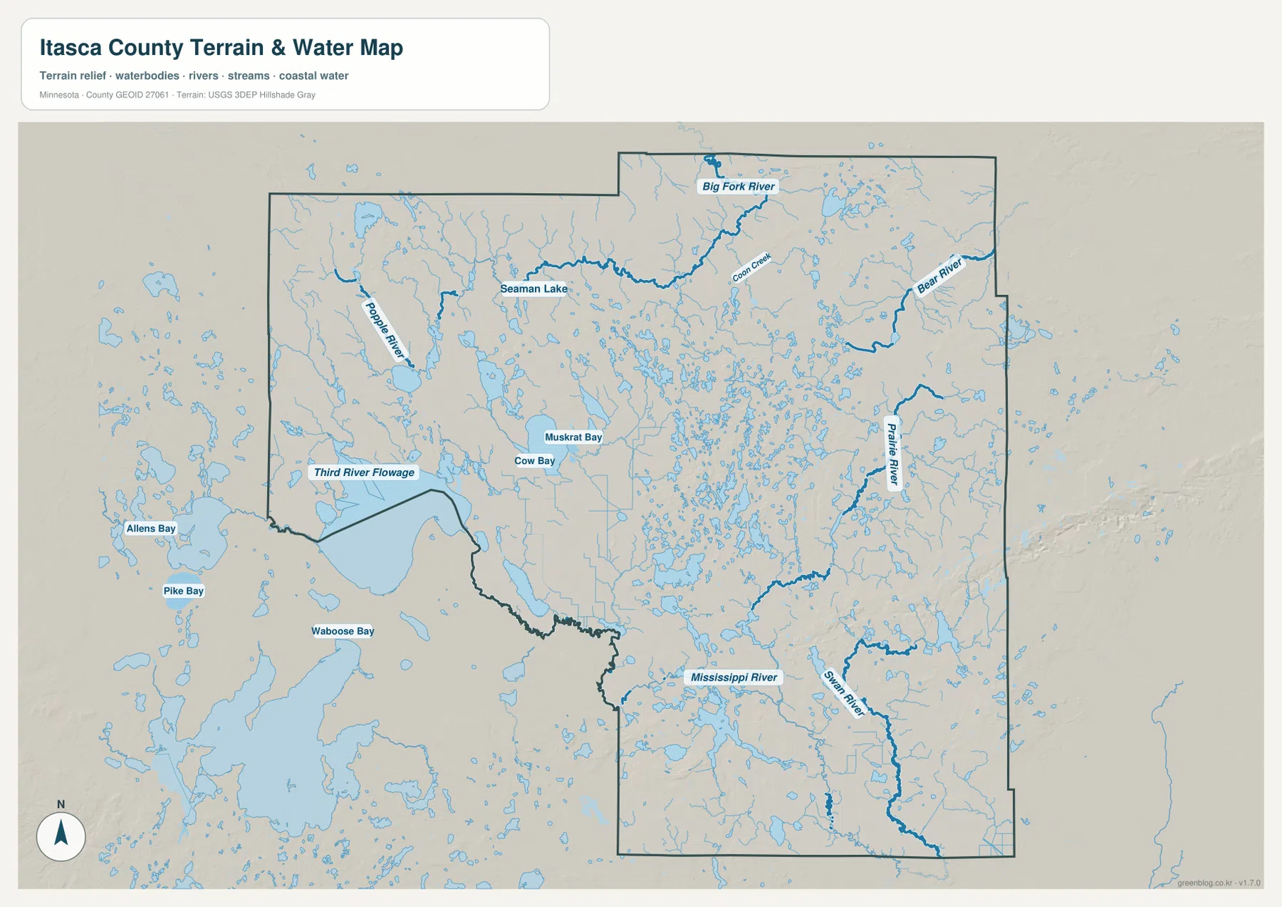
Prairie River and Swan River add another layer to the southern and eastern map. Prairie River runs through the eastern interior, while Swan River bends through the southeast. Their lower corridors connect with the broader lake-and-river landscape around Grand Rapids and the eastern communities, making the southern half much more hydrologically complex than the road map alone suggests.
Itasca County’s official Maps page provides a GIS Map Viewer, County Highway Map, Plat Book links, and GIS data download options. Those county tools are the better choice when a task requires parcel, highway, or detailed administrative information; the maps on this page are designed for readable county-wide orientation and downloadable reference.
Big Fork River and a lake-rich northern interior
Northern Itasca County has a very different water pattern from the Grand Rapids area. Big Fork River is the clearest named river near the north-central part of the map, surrounded by a remarkable number of small lakes and short tributaries. The community of Bigfork appears on the general map in the same broad northern region, but the river and town should still be located separately rather than assumed to occupy one exact point.
Turtle River winds through the northwest, with Seaman Lake providing another useful landmark nearby. Bear River is prominent in the northeast, and Coon Creek is labeled in the upper interior. Large cities are scarce across this half of the county, but water features are extremely dense, so rivers and lakes become more useful reference points than settlement names.
The map also shows large named waters beyond the western county boundary, including Allens Bay, Pike Bay, and Waboose Bay, while Third River Flowage sits near the western side. Those outside labels should not be confused with waters entirely inside Itasca County, but they help show how the county fits into a much larger lake landscape extending west toward the Cass and Beltrami County region.
A 351–529 meter range broken into several upland areas
The supplied elevation map reports an actual range of about 351 to 529 meters, with a mean near 414 meters. Higher brown terrain does not sit in one single corner. Distinct upland areas appear in the northwest, across parts of the northeast and east, and again in the southwest. Lower green terrain spreads through many central and southern lake and river basins.
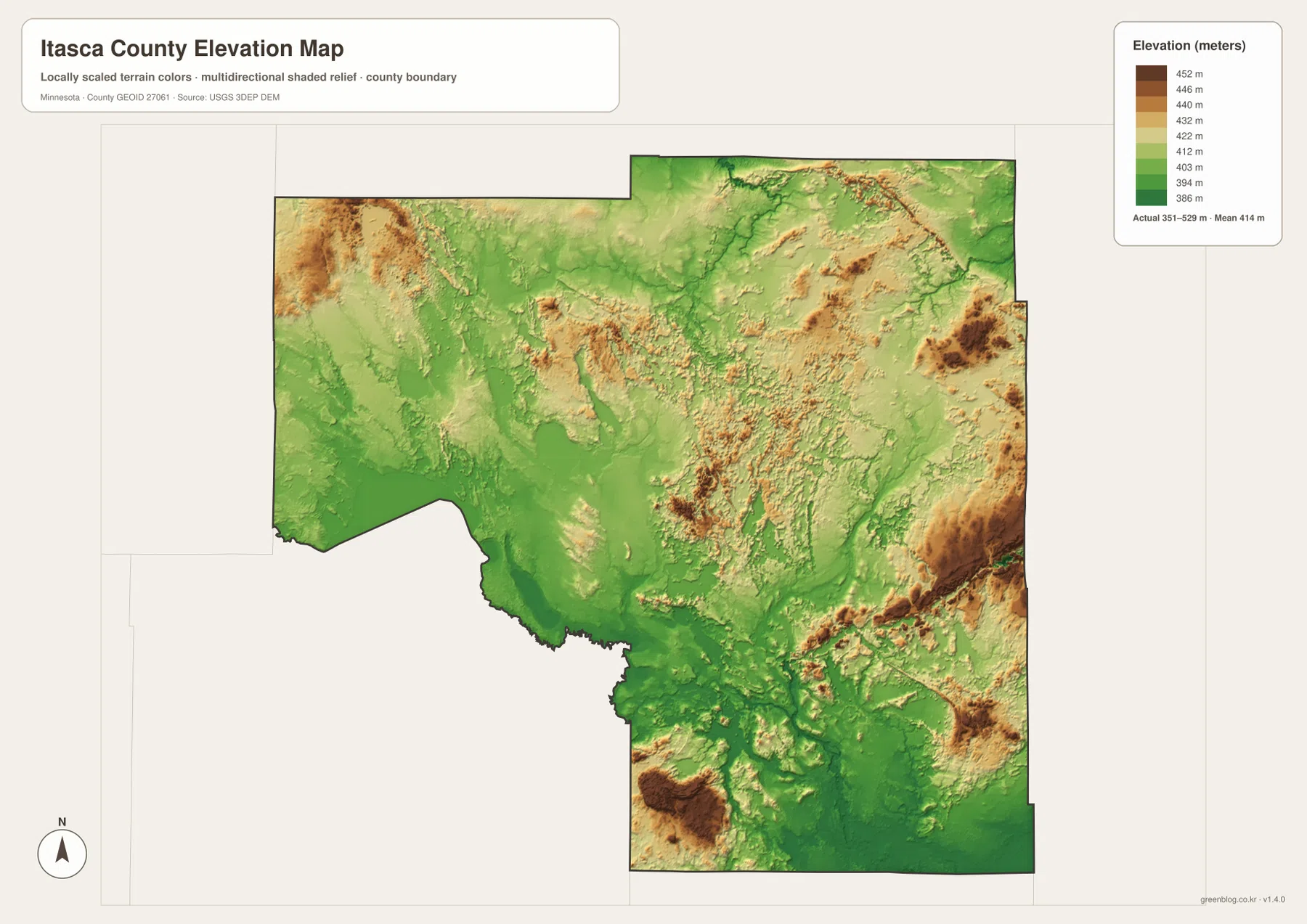
The northwest contains one of the clearest high areas, but the terrain drops toward broad green zones farther east and south. Another set of higher ridges appears through the northern and eastern interior. This makes the county more complicated than a simple west-to-east slope; high ground repeatedly gives way to low lake basins and river channels.
Eastern Itasca County also contains substantial relief. Lower corridors associated with Prairie River and Bear River cut through higher tan and brown terrain, while additional uplands appear near the southeastern edge. The water and elevation maps line up well here: named rivers follow visibly lower paths between more elevated areas.
The Mississippi River side of the south is generally lower than many northern and eastern uplands, although southern Itasca County is not uniformly flat. A separate high area appears toward the southwest, and smaller hills interrupt the Grand Rapids region. The better county-wide description is a collection of uplands divided by broad river and lake lowlands rather than one continuous ridge or plain.
This elevation surface is suitable for county-scale comparison, not surveying or engineering. It should not be used for exact building elevations, road grades, drainage design, or parcel-level contour decisions. Detailed USGS 3D Elevation Program products or professional survey data are appropriate when precise elevations matter.
Comparing the Grand Rapids corridor with the northern interior
The Grand Rapids area combines several features in a compact space: major communities, important roads, the Mississippi River, and many smaller lakes. Cohasset, Coleraine, and Bovey sit close enough to make the south-central part of the county feel connected, while Routes 2 and 169 provide clear transportation references. On the elevation map, the river corridor is generally lower than several uplands farther north and east.
North toward Bigfork and Effie, the pattern reverses. Towns and roads become less frequent, but Big Fork River, Turtle River, Bear River, and hundreds of small water bodies dominate the map. This difference is why a single settlement map cannot explain Itasca County well: the northern half is much easier to understand when the water and elevation views are added.
Nashwauk and Keewatin occupy an interesting transition on the eastern side. They extend the southern settlement band eastward, but the nearby landscape becomes increasingly shaped by rivers and higher terrain. On the city map they are simply eastern communities; on the water and elevation views they sit close to a much more rugged natural setting than Grand Rapids itself.
Choosing the best Itasca County map for the task
Use the general county map when roads, boundaries, and a wider set of place names need to appear together. The city map is cleaner when the goal is to compare Grand Rapids, Cohasset, Coleraine, Keewatin, Nashwauk, and Deer River without the distraction of every road and lake. Together, the two views make the strong southern concentration of settlement easy to explain.
The water map is the stronger choice for the Mississippi River, Big Fork River, Prairie River, Turtle River, Bear River, and the county’s dense lake landscape. Pair it with the elevation map when the goal is to show how river valleys and lake basins occupy lower terrain between several upland areas. In a water-rich county such as Itasca, those two natural-feature views add information that a road map cannot.
For printing or image editing, the original JPG files in the ZIP provide more resolution than the WebP previews embedded in the article. Each JPG measures 3638 by 2572 pixels, and the archive contains the county, city, water, and elevation maps.
Official county and federal sources for detailed work
Itasca County’s official Surveying and Mapping page provides a GIS Map Viewer, County Highway Map, Plat Book resources, and links for GIS data downloads. The county also lists its main contact location in Grand Rapids. Parcel, highway, legal boundary, and other administrative questions should rely on those current official county tools rather than on a general-purpose overview map.
U.S. Census Bureau TIGER/Line files are appropriate for boundary, road, and place data; USGS National Hydrography supports river and stream work; and the USGS 3D Elevation Program provides detailed elevation products. The maps on this page are intended to make the county’s major settlement, water, and relief relationships easy to understand and reuse.
Frequently Asked Questions
Are the main cities concentrated in southern Itasca County?
Yes. The supplied city map places Grand Rapids, Cohasset, Coleraine, Keewatin, Nashwauk, and Deer River in the southern or southeastern part of the county. Smaller northern communities such as Bigfork and Effie are visible on the general map but are not part of the six-city index.
Where does the Mississippi River cross Itasca County?
The water map shows the Mississippi River across the southern part of the county near the Grand Rapids-Cohasset area. Prairie River and Swan River are separate waterways in the eastern and southeastern interior.
What elevation range is shown for Itasca County?
The supplied elevation map reports an actual range of about 351–529 meters and a mean near 414 meters. Higher terrain appears in several separate areas, including the northwest, parts of the east, and the southwest, while many river and lake basins are lower. Exact site elevations require detailed USGS or survey data.
Map File Information
Download the original high-resolution JPG versions of the Itasca County maps shown on this page in one ZIP file.
- Included Files: county map, city map, water map, elevation map
- Printable Size: each JPG is 3638 × 2572 px
- File Type: ZIP containing 4 JPG files
Related Maps
Sources and references
- Itasca County Maps – official GIS Map Viewer, County Highway Map, Plat Book, and GIS data resources
- U.S. Census Bureau TIGER/Line Shapefiles – boundary, road, and place data
- USGS National Hydrography – river, stream, and water data
- USGS 3D Elevation Program – elevation data and products
Green Map creates custom-edited map images using open geographic data sources such as geoBoundaries, Natural Earth, OpenStreetMap, and government open data. These maps are edited visual materials, not raw data files, and are provided for education, documents, presentations, and graphic reference.