Manistee County occupies a broad section of northwestern Michigan’s Lower Peninsula, with Lake Michigan forming its western edge and the city of Manistee anchoring the southwest. From that shoreline, US-31 runs north toward Onekama and Bear Lake, while M-55 crosses the southern part of the county toward Wellston and the interior. The maps on this page connect those roads and communities with the Manistee River, inland lakes, and changing elevation. High-resolution JPG versions of all four supplied maps can also be downloaded together from the map file box near the end of the article.
A useful way to orient yourself is to start at Manistee and then move north and east. Onekama sits farther up the Lake Michigan side near Portage Lake, Bear Lake lies inland to the north, and Kaleva and Brethren occupy the interior. Copemish appears near the northeastern edge. Manistee County’s official profile describes the county as a Lake Michigan community with Portage Lake, Bear Lake, Manistee Lake, and numerous rivers and streams, a description that matches the strongest features visible in the supplied maps.
Table of Contents
US-31 and M-22 connect Manistee with the lakeside communities to the north
The general county map places Manistee and Eastlake close together in the southwest, near Manistee Lake and the Lake Michigan shore. Parkdale and Oak Hill are also marked nearby, giving the lower-left corner of the map the county’s most concentrated cluster of named places. US-31 passes through this area and continues north, making it the easiest road to use as a reference when comparing Manistee with Onekama and Bear Lake. M-22 bends toward Onekama and the coast, while M-110 appears as a shorter route just north of Manistee.
Farther inland, M-55 leaves the Manistee area and runs east across the southern half of the county toward Wellston. Brethren lies north of that corridor, and Kaleva is farther north again near the center of the county. In the northeast, M-115 passes near Copemish. The result is not a single continuous urban strip but a set of coastal and inland communities connected by a few important highways. Road spacing also changes noticeably: routes are relatively close together around Manistee, while larger gaps open across the central and eastern interior.
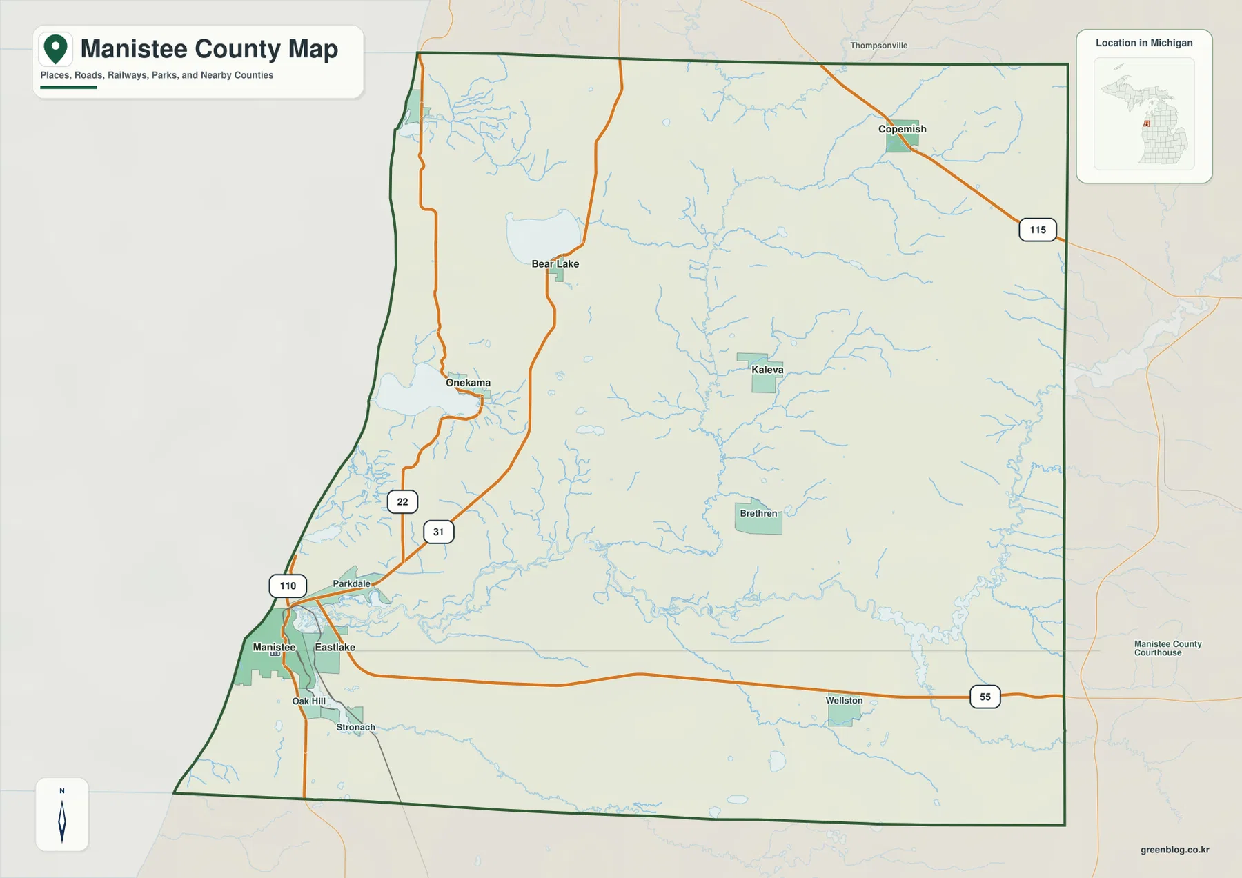
The county boundary adds another layer of context. Benzie County is to the north, Grand Traverse County is toward the northeast, and Wexford County lies to the east. Mason and Lake counties are on the southern and southeastern side, while the entire western side faces Lake Michigan. This map is useful for understanding broad location and connections, but it is not a parcel or legal-boundary product. Property lines, ownership questions, and current jurisdictional details should be checked against official county records or current Census boundary data.
The ranked community map separates the Manistee coast from smaller inland centers
The city distribution map highlights six communities rather than every settlement in the county. Manistee is ranked first and sits on the southwest shore. Eastlake, ranked third, is immediately to the east, creating a close pair at the lower end of the county. Onekama is positioned well to the north near Portage Lake, while Bear Lake lies still farther north and inland. Kaleva occupies a central-northern position, and Copemish is near the northeastern boundary. Those locations make the map especially useful for seeing how the county’s main named centers are spread between the coast and interior.
The index printed below the map lists Manistee at 6,275, followed by Kaleva, Eastlake, Onekama, Bear Lake, and Copemish. These figures belong to the supplied map’s city index and should not be treated as a substitute for a current Census population table. The geographic pattern is the more important part of this graphic. Manistee and Eastlake form the strongest southwestern concentration, Onekama and Bear Lake create a second northwestern reference area, and Kaleva and Copemish show how settlement continues inland rather than remaining entirely on the Lake Michigan shore.
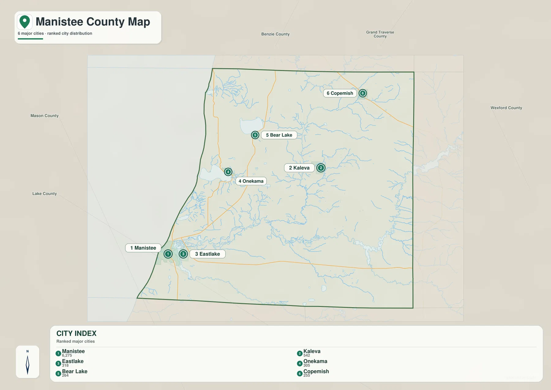
For trip planning or a classroom overview, the ranked map works best when paired with the general county map. The ranked version quickly identifies the main communities, but it omits smaller places such as Brethren, Wellston, Parkdale, and Stronach that help explain the interior. If your route stays near Lake Michigan, Manistee and Onekama provide useful anchors. If you are looking toward the Manistee River or the eastern part of the county, Brethren and Wellston on the general map become more important. In other words, the community index is a starting point rather than a complete settlement map.
The Manistee River crosses the southern interior while Bear Creek links the central and northern waters
The terrain and water map gives the Manistee River a strong visual role across the southern half of the county. The river enters from the east near Tippy Dam Pond, curves across the interior, and continues west toward Manistee Lake and Lake Michigan. Pine Creek approaches from the southeast and joins the broader river system. This water corridor helps explain why the southern interior looks different from the northern half of the county: instead of one large lake dominating the scene, a long river valley and many smaller tributaries occupy the landscape.
In the center of the county, Bear Creek and Cedar Creek are labeled, and farther north Lemon Creek and Little Bear Creek extend toward Bear Lake. Big Bear Creek and 3rd Creek appear in the northeastern portion of the map. Several lakes provide distinct landmarks along the western side and in the interior, including Portage Lake, Bear Lake, Bar Lake, Manistee Lake, Pine Lake, and Tippy Dam Pond. Together they show that Manistee County’s water geography is divided among the Lake Michigan coast, the Manistee River system, and a collection of inland lakes and tributaries.
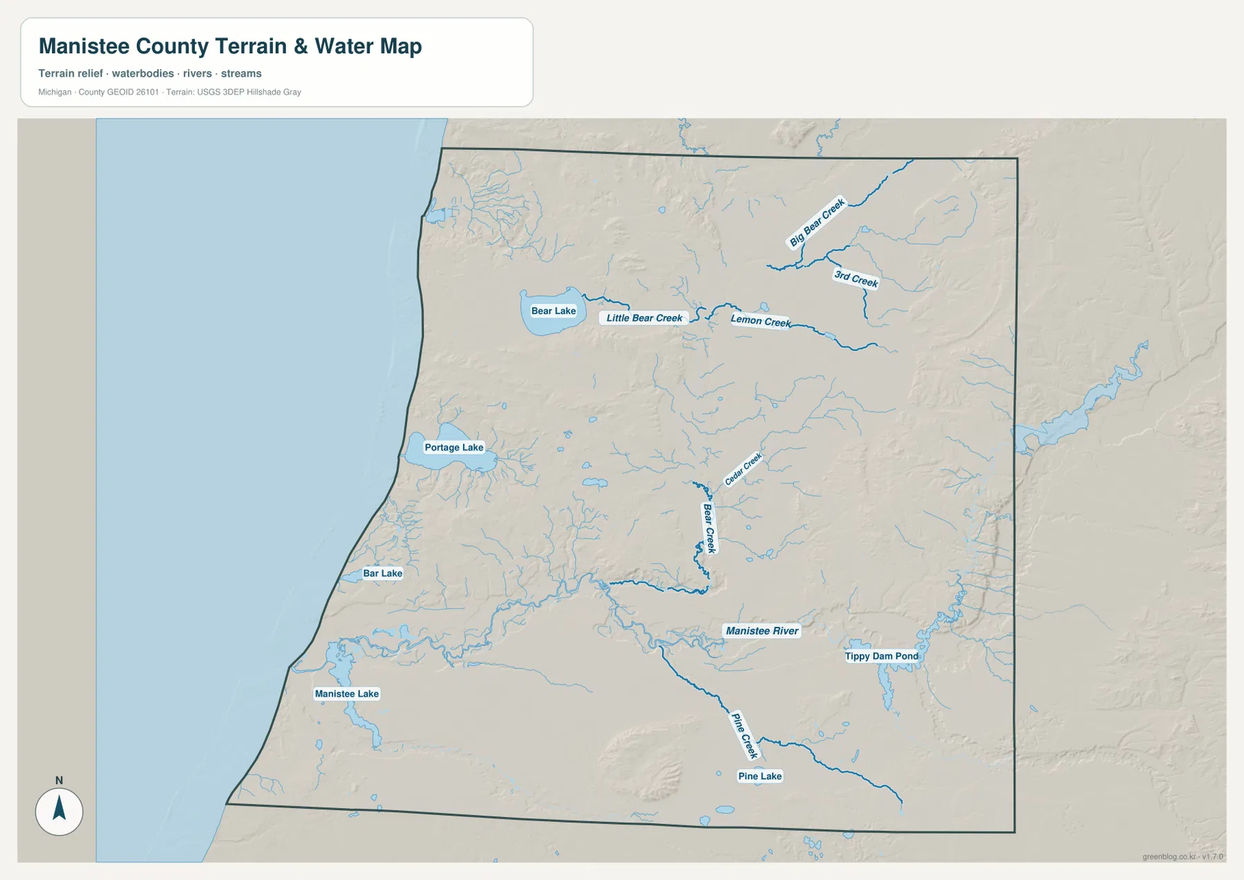
The county’s official overview also names Portage Lake, Bear Lake, and Manistee Lake among its important waters and notes the abundance of rivers and streams. The map is a useful reference for locating those features, but it is not designed for flood determination, boating navigation, water depth, wetland regulation, or real-time flow conditions. Those questions require current specialized sources. For general geographic study, however, it clearly shows where the main river corridor lies and how smaller creeks and lakes fill the areas between the highway network.
Low river corridors are framed by higher ground in the east and northwest
The elevation map reports an actual county range of roughly 176 to 352 meters, with a mean of about 239 meters. The lowest greens appear along parts of the Lake Michigan edge and, most clearly, through the broad Manistee River corridor across the southern interior. Manistee and Manistee Lake also sit within the lower western zone. This low band corresponds closely with the river shown on the water map, so the two graphics reinforce one another: the river occupies a broad low area that runs east-west before reaching the coast.
Higher terrain is much more obvious along the eastern side of the county and in parts of the northwestern interior. Brown and tan ridges rise near the Wexford County side, and several isolated uplands appear east of the central lowlands. In the northwest, higher ground sits behind the Lake Michigan shoreline, producing a quick change from low coastal areas to elevated inland terrain. The county therefore cannot be described simply as flat lakeshore country. Its relief combines low coast and river valleys with interior hills that approach or exceed 300 meters in several places.
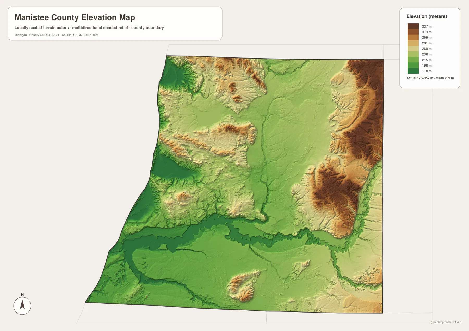
This is a generalized county-scale elevation surface rather than survey-grade measurement. It is appropriate for comparing major terrain differences, but not for determining an exact building-site elevation, drainage design, flood exposure, or road engineering. For those purposes, use the original USGS 3D Elevation Program data and, where necessary, professional field survey information. As a regional reference, the map is particularly helpful for understanding how the Manistee River occupies a lower corridor and how the surrounding tributaries descend from higher interior ground.
Choose the map by whether you need roads, communities, water, or relief
If you are unfamiliar with Manistee County, begin with the general county map. Find Manistee, follow US-31 north to Onekama and Bear Lake, then trace M-55 east toward Wellston. That sequence gives you a fast sense of the county’s main road framework. The ranked community map is better when you want a cleaner view of where the six highlighted population centers sit. It shows the strong southwest position of Manistee and Eastlake while keeping the more separated northern and northeastern communities visible.
For natural geography, start with the water map and locate the Manistee River between Tippy Dam Pond and the western lakes. Then compare it with the elevation map to see how the river follows a lower corridor between higher areas. Portage Lake and Bear Lake are useful reference points in the northwestern half, while Bear Creek and its related tributaries help fill in the central interior. Using these maps together makes it easier to connect a town or road with the nearest lake, river, or change in terrain rather than viewing each feature in isolation.
The WebP images in the article are sized for quick viewing online. The downloadable archive contains the original 3638 × 2572 pixel JPG versions, which are better for enlarging road labels, studying place names, or preparing printed material. They can support general travel orientation, teaching, presentations, and local geographic reference. They should not replace current navigation services, parcel records, legal boundary documents, flood maps, marine charts, or engineering and survey products.
Frequently Asked Questions
Which map is best for comparing Manistee, Onekama, and Bear Lake?
The general county map is the best starting point because it shows all three communities together with US-31 and M-22. Manistee is on the southwest shore, Onekama is farther north near Portage Lake, and Bear Lake is still farther north and slightly inland. The road network makes their relative positions easy to compare.
Where can I see the Manistee River and Tippy Dam Pond most clearly?
Use the terrain and water map. It emphasizes the Manistee River across the southern interior and labels Tippy Dam Pond on the eastern side. It also adds Bear Creek, Cedar Creek, Pine Creek, Bear Lake, Portage Lake, and Manistee Lake, making it easier to compare the river with nearby tributaries and lakes.
Can the 176–352 meter elevation range be used for construction or flood decisions?
No. The supplied elevation map is intended for county-scale geographic comparison. It shows broad differences between the low coast and river corridor and higher interior terrain, but it is not a survey, engineering surface, or flood map. Exact site work should use current official elevation data and professional measurements when required.
Map File Information
The ZIP contains high-resolution JPG originals of the Manistee County general map, ranked community map, terrain and water map, and elevation map. These originals are larger than the WebP images used in the article and are better suited to zooming and printing.
- Included Files: Use only the versions confirmed in the article and supplied images
- File Type: Use the confirmed download contents
- Intended Use: Printing, education, presentations, and map-based projects
Related Maps
Sources and References
- Manistee County – About Our County: official overview of the county’s Lake Michigan setting, communities, lakes, and rivers.
- Library of Michigan – Manistee County Guide: state library guide to local history, maps, government publications, and county resources.
- U.S. Census Bureau TIGER/Line Shapefiles: reference data for county boundaries and roads.
- USGS National Hydrography: reference source for rivers, streams, and lakes.
- USGS 3D Elevation Program: reference source for elevation data.
Green Map creates custom-edited map images using open geographic data sources such as geoBoundaries, Natural Earth, OpenStreetMap, and government open data. These maps are edited visual materials, not raw data files, and are provided for education, documents, presentations, and graphic reference.