Johnson County in northwestern Arkansas changes dramatically from the low Arkansas River Valley around Clarksville to the high Boston Mountains across the northern half. Clarksville, Lamar, Hartman, Coal Hill, and Knoxville are all concentrated near the southern valley and the Interstate 40 corridor, while Oark and Ozone sit much farther north among steep ridges and narrow stream valleys. The water map shows the Mulberry River, Big Piney Creek, Spadra Creek, Horsehead Creek, and Lake Dardanelle, and the elevation map spans roughly 103 to 722 meters. The four high-resolution JPG maps shown on this page are available together in one downloadable ZIP.
The north-south terrain contrast is the key to understanding the county. The Encyclopedia of Arkansas describes northern Johnson County as part of the Boston Mountains and Ozark National Forest, while the southern portion lies in the lower Arkansas River Valley. The supplied maps show the same division clearly. Clarksville, the county seat, sits in the low southern belt, and the land climbs rapidly toward Ozone and Oark. Starting with Clarksville gives readers an easy reference for roads, communities, streams, and the strong elevation change.
Table of Contents
Clarksville and the Interstate 40 corridor concentrate most major communities
Clarksville is the largest developed area on the general county map. Hartman and Coal Hill extend west along the same southern corridor, Lamar lies just east of Clarksville, and Knoxville occupies the southeastern extension near Lake Dardanelle. Interstate 40 and Route 64 pass through or near this line of communities, creating a much denser road network than anything visible in the northern mountains. Following the corridor from Coal Hill through Hartman and Clarksville to Lamar is the simplest way to understand the populated southern side of the county.
Roads become narrower and more winding as the map moves north. Route 21 heads into the interior toward Ozone, while Route 103 climbs through the western uplands. Around Hagarville, Routes 123 and 292 cross the eastern side, and farther northwest the Oark area is reached by roads including 34 and 215. Their curves and spacing reflect the terrain: the southern valley supports straighter east-west travel, while northern routes follow ridges, creek valleys, and mountain gaps.
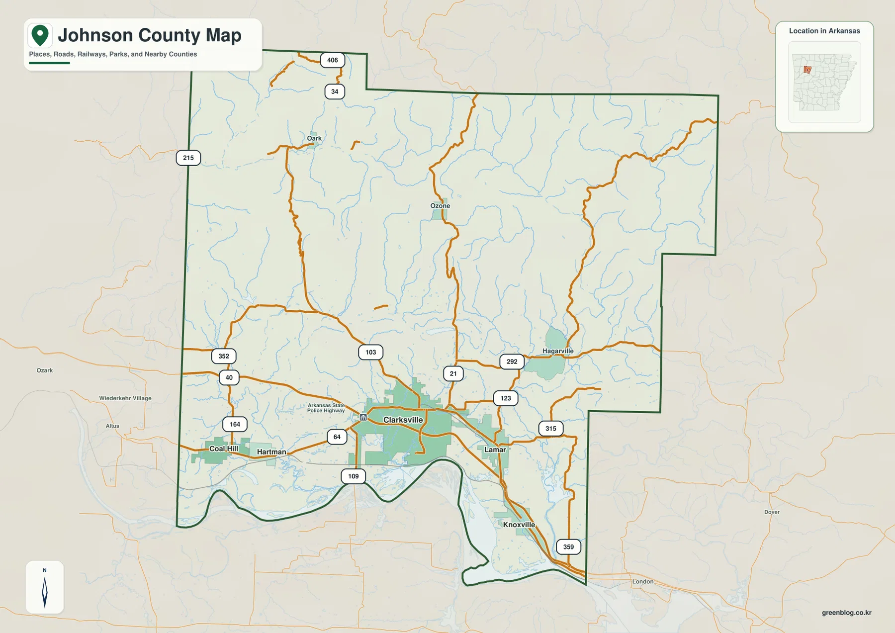
The county outline also changes with the landscape. A broad northern mountain block occupies most of the map, while the southern edge becomes irregular along the Arkansas River Valley and Lake Dardanelle side. The southeastern portion narrows around Knoxville before reaching the reservoir corridor. Franklin, Logan, Yell, Pope, Madison, and Newton counties are labeled outside the boundary, helping place Johnson County between the Ozark highlands and the river valley without losing the local detail.
The ranked city map keeps all five major communities in the southern valley
The city map ranks five major communities. Clarksville is number 1, followed by Lamar at 2, Coal Hill at 3, Hartman at 4, and Knoxville at 5. The numbered markers are rankings, not distance measurements. The most important pattern is geographic: every ranked community lies in the southern portion of the county. The broad mountain area to the north contains smaller settlements such as Oark and Ozone, but none appears among the five ranked cities on this map.
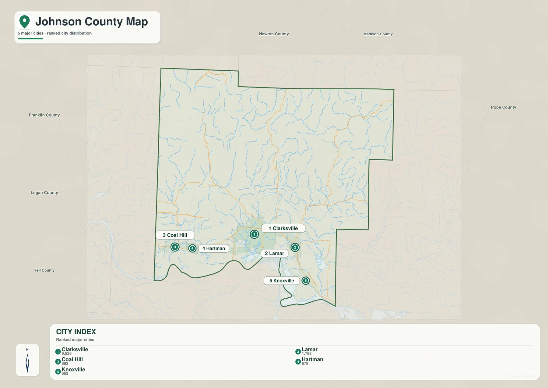
Clarksville and Lamar sit close together near the center of the southern road corridor, while Hartman and Coal Hill extend west. Knoxville is farther southeast near the Lake Dardanelle side of the county. Comparing the ranked city view with the road map helps explain why Interstate 40 and Route 64 are so important locally: they run through the same low valley that contains most of the county’s larger communities.
The city legend also displays numeric values next to the names, but this article does not treat those values as current population estimates. The supplied map clearly supports the ranking and locations of the five communities, so those are the facts used here. Current population or administrative statistics should be checked against recent Census data rather than inferred from a simplified map legend.
Mulberry River and Big Piney Creek cut through the northern mountain country
The Mulberry River is the most prominent named river across the northern half of the terrain and water map. It winds through deep valleys in the Boston Mountains, with many short tributaries dropping from the surrounding ridges. The Encyclopedia of Arkansas notes that the river rises in the mountain country of northern Franklin and Johnson counties before flowing toward the Arkansas River. On the supplied map, its bends are tightly connected to the rugged relief that dominates the northern landscape.
Big Piney Creek occupies the northeastern side, while Cedar Creek and Dry Creek descend through nearby mountain valleys. Farther south, Illinois Creek and Spadra Creek lead toward the Clarksville area, and Little Spadra Creek and Dry Spadra Creek branch across the west-central interior. These streams make the transition from high mountain drainage to the wider southern valley visible. The terrain shading is especially useful here because nearly every major creek follows a lower corridor between long ridges.
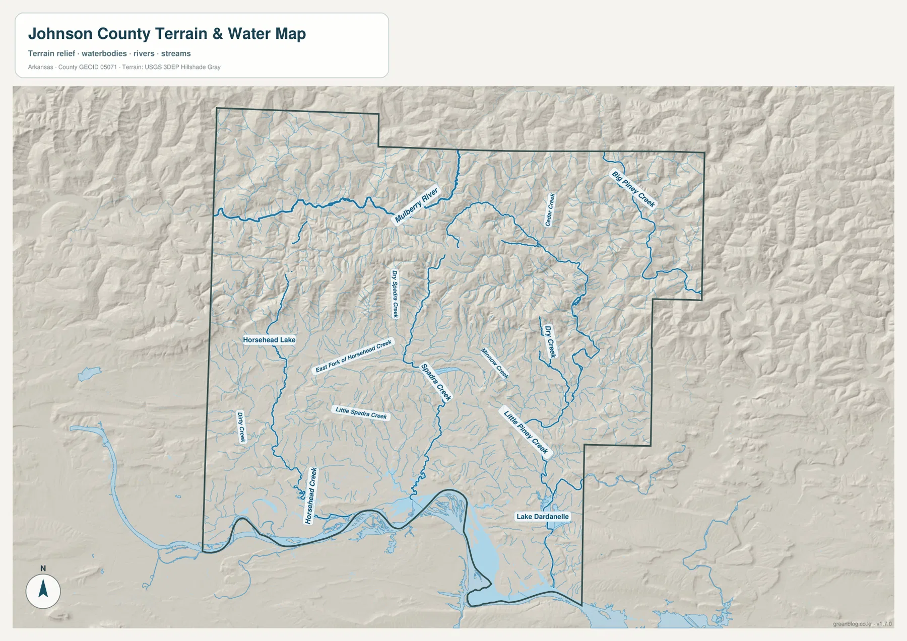
On the southwestern side, Horsehead Creek and the East Fork of Horsehead Creek pass near Horsehead Lake. Spadra Creek approaches the Clarksville lowland from the north, while Little Piney Creek drains the southeastern side toward Lake Dardanelle. The reservoir forms a broad water edge at the bottom of the county, which is visually very different from the narrow, twisting mountain streams to the north. Knoxville sits close to this lower reservoir landscape.
This terrain and water map is intended for general geographic reference. It does not show current river stage, whitewater conditions, flood risk, private-property boundaries, fishing regulations, or live road access. Conditions on the Mulberry River, Big Piney Creek, and smaller mountain streams can change quickly after rainfall. For recreation or safety decisions, use current USGS information and guidance from the agency responsible for the specific waterway.
Elevation rises from about 103 meters near the river valley to more than 700 meters in the north
The supplied elevation map shows an actual range of about 103 to 722 meters, with a mean near 308 meters. That is roughly 619 meters of relief within Johnson County. Dark green covers much of the southern Clarksville-Lamar-Hartman corridor, but elevation increases quickly north of the valley. Brown and tan ridges dominate the Boston Mountains, and the highest terrain is spread across a broad northern area rather than concentrated at one isolated peak.
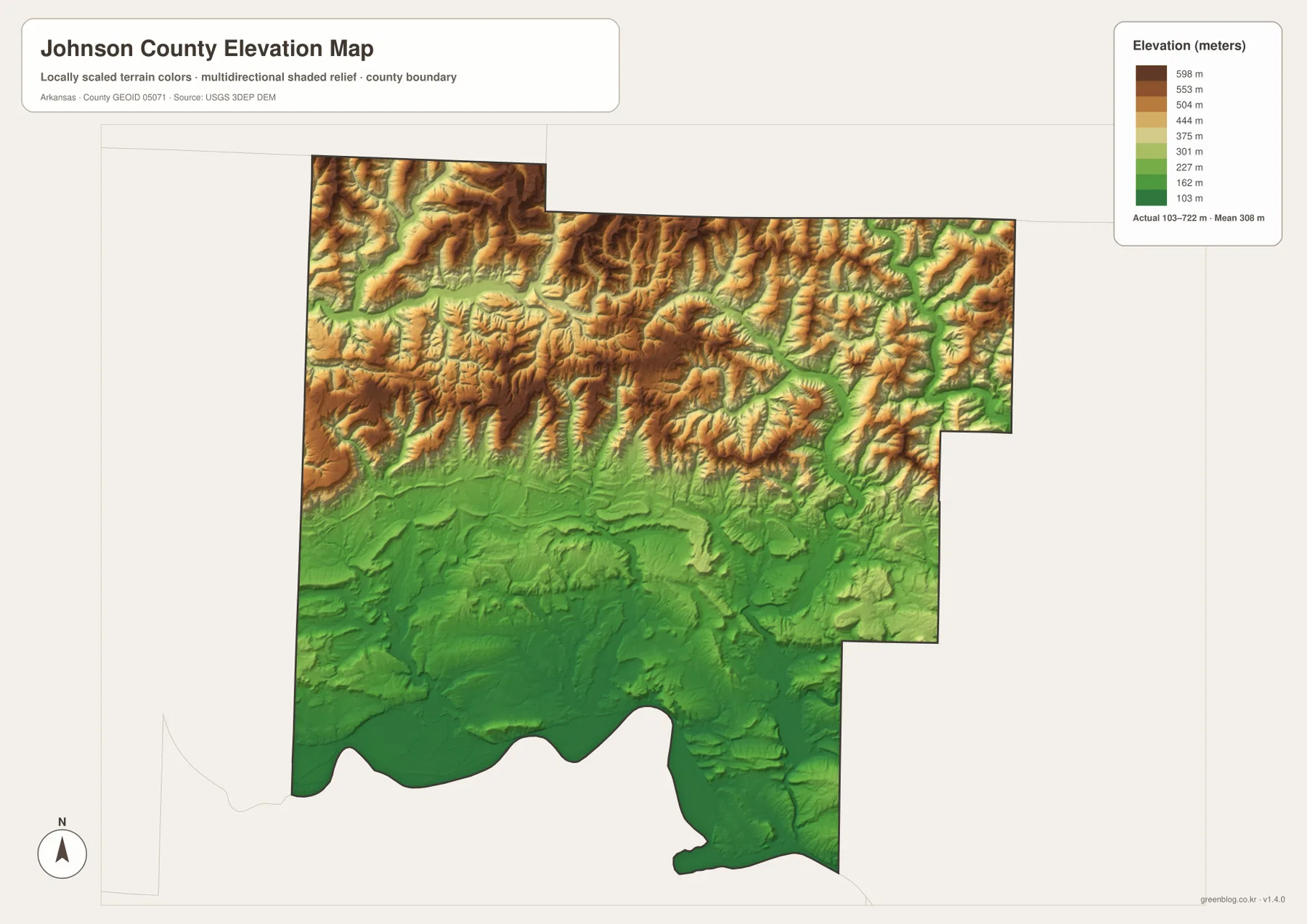
The northern highlands are built from repeated ridges separated by deep stream valleys. Around Oark, Ozone, and the northeastern corner, the elevation colors alternate rapidly between brown ridges and greener channels. The Mulberry River, Big Piney Creek, Cedar Creek, and their tributaries occupy many of those lower corridors. The same terrain also explains why mountain roads twist and why communities are much more widely spaced than along Interstate 40 in the south.
South of the mountain front, the land falls quickly toward the Arkansas River Valley. Clarksville sits near this transition, where the high ridges give way to a broader low surface. Lamar and Knoxville remain in lower terrain toward Lake Dardanelle, while Hartman and Coal Hill lie near the western edge of the valley with foothills rising not far to the north. The county is therefore best understood as a direct meeting of Boston Mountain uplands and river-valley lowlands rather than as one uniform mountain landscape.
A northbound trip from Clarksville reveals the county’s geography fastest
A useful way to compare all four map views is to begin at Clarksville and move north toward Ozone and Oark. Around Clarksville, the road network is dense, the elevation is low, and Spadra Creek approaches the valley. Following Routes 21 and 103 northward, larger towns disappear, the roads become more winding, and the terrain rises sharply. The water map also shifts from broad southern drainage toward the Mulberry River and tightly confined mountain streams.
Turning southeast from Clarksville creates the opposite comparison. Lamar and Knoxville remain in the lower Arkansas River Valley, and Lake Dardanelle becomes a stronger reference feature. Roads are straighter and communities are closer together than in the northern mountains. The fact that all five ranked cities lie in this southern zone becomes much easier to understand once the elevation and water maps are viewed beside the road map.
High-resolution JPG files for Clarksville roads and mountain-water detail
The WebP images in the article are optimized for quick page viewing. The download ZIP contains the same four maps as high-resolution JPG files, each measuring 3638 × 2572 pixels in landscape orientation. Use the general map for communities and roads, the ranked city map for the five major places, the terrain and water map for the Mulberry River, Big Piney Creek, Horsehead Creek, and Lake Dardanelle, and the elevation map for comparing the southern valley with the Boston Mountains.
The JPG files are suitable for classroom reference, presentations, trip preparation, personal printing, and general orientation. They should not replace legal boundary records, parcel surveys, flood or whitewater safety information, engineering plans, or live navigation. When exact or current information is required, consult Census TIGER/Line boundaries, USGS hydrography, USGS elevation data, and the appropriate state or local source for the specific decision.
Frequently Asked Questions
Why is northern Johnson County so much higher than the south?
Northern Johnson County lies in the Boston Mountains, while Clarksville and the southern communities occupy the lower Arkansas River Valley. The supplied elevation map shows an actual range of about 103–722 meters with a mean near 308 meters, so the change from valley to mountain terrain is substantial.
Do the numbers 1 through 5 on the city map show distances?
No. They are ranking markers for the five major communities shown on the map. Clarksville is ranked first, followed by Lamar, Coal Hill, Hartman, and Knoxville. The numbers do not represent straight-line mileage or driving distance.
Where are the Mulberry River and Lake Dardanelle on the map?
The Mulberry River winds across the northern mountain portion of Johnson County, while Lake Dardanelle forms a broad water feature along the southern and southeastern edge. Comparing them shows the difference between narrow Boston Mountain river valleys and the much wider Arkansas River Valley landscape.
Map File Information
The ZIP contains the general county map, ranked city map, terrain and water map, and elevation map as high-resolution JPG files for printing or offline reference.
- File Type: ZIP containing 4 JPG files
Related Maps
Sources and references
- Encyclopedia of Arkansas – Johnson County – county seat, Boston Mountains, Arkansas River Valley, and county geography
- Encyclopedia of Arkansas – Clarksville – Clarksville and county-seat information
- Encyclopedia of Arkansas – Mulberry River – Mulberry River geography in northern Johnson County
- U.S. Census Bureau TIGER/Line Shapefiles – county boundary and road data
- USGS National Hydrography – rivers, streams, lakes, and hydrography data
- USGS 3D Elevation Program – elevation and terrain data
Green Map creates custom-edited map images using open geographic data sources such as geoBoundaries, Natural Earth, OpenStreetMap, and government open data.
These maps are edited visual materials, not raw data files, and are provided for education, documents, presentations, and graphic reference.