Lafayette County in southwestern Arkansas is easy to recognize by its long north-south shape, the large bends of the Red River along the western side, and the cluster of Stamps, Lewisville, and Buckner near U.S. 82 in the north. The county is mostly low, but short ridges rise across the north-central and northeastern sections, creating a clear contrast with the flatter river country to the west and southwest. This page shows communities, roads, city connections, creeks, lakes, and an actual elevation range of about 54 to 121 meters. The same four maps are available as high-resolution JPG files in one downloadable ZIP.
Lewisville is the county seat, while Stamps is used as the hub city on the supplied city-connections map. That distinction is useful when reading the maps. The Lafayette County Courthouse is labeled in Lewisville, and Stamps lies just to the east where several roads meet. Buckner is farther east along the same general northern corridor, while Bradley is much farther south near Route 29. Looking at the northern towns first and then following the long county shape toward Bradley makes the road and water patterns much easier to understand.
Table of Contents
U.S. 82 ties Stamps, Lewisville, and Buckner together across the north
U.S. 82 is the clearest east-west road on the general county map. It passes through the Lewisville-Stamps area and continues toward Buckner, placing the three northern communities close to one another. Route 29 turns south from Lewisville toward Bradley, while Route 313 follows another long north-south path from the Stamps side. Once U.S. 82 is located, these two roads provide an easy framework for reading the rest of the county.
The southern half is much less urban. Route 29 remains an important reference around Bradley, Routes 314 and 360 cross the lower western side, and Routes 160 and 53 run close to the eastern boundary. Route 3 is labeled along the southern edge. Compared with the compact northern road cluster, the south has fewer towns, greater spacing between major routes, and a much denser pattern of small streams and low drainage corridors.
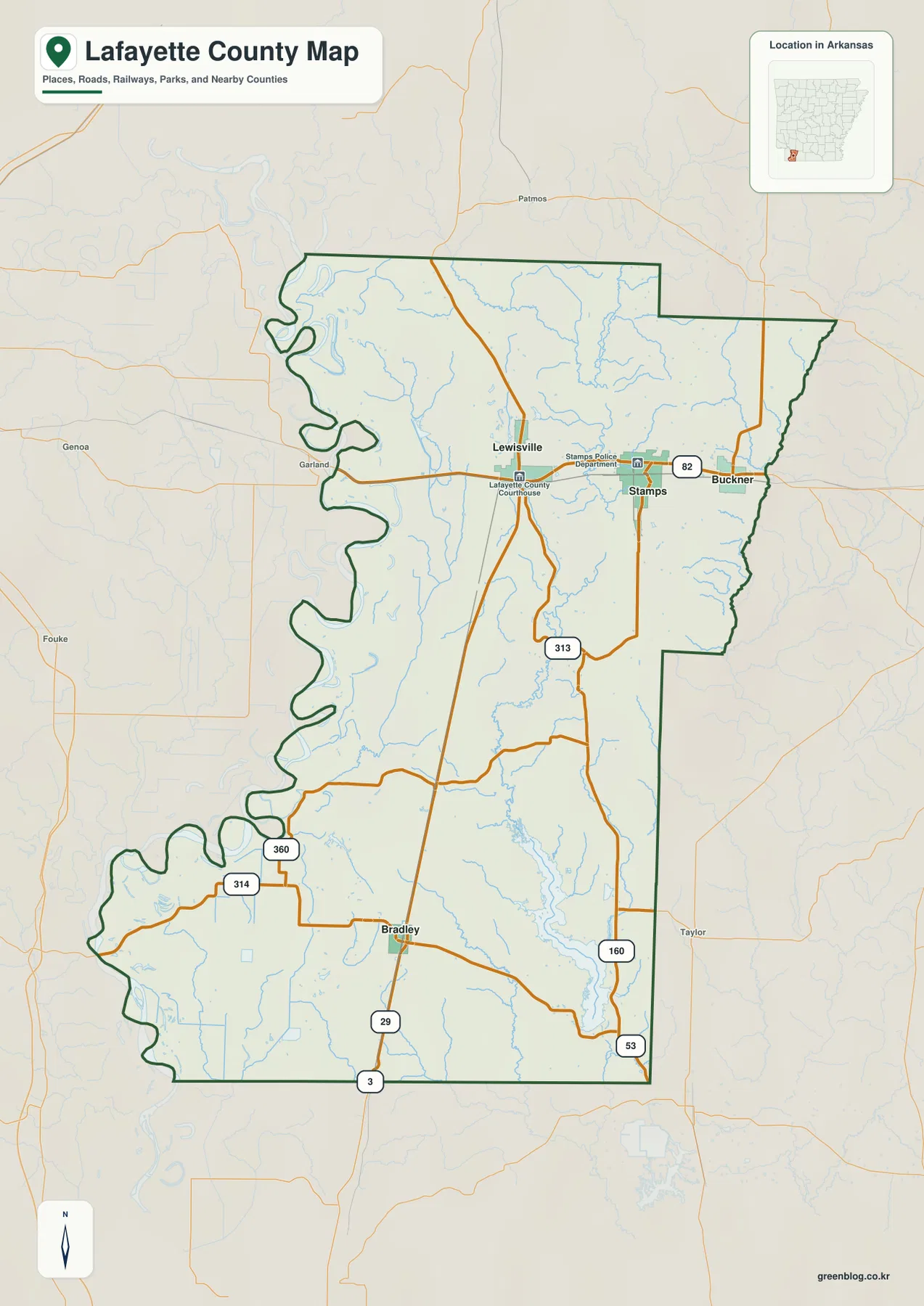
The western boundary is one of the map’s most distinctive features. Large curves and narrow projections repeat from the northwest to the southwest because the county follows the Red River side of southwestern Arkansas. The eastern boundary contains much longer straight segments and a rectangular northeastern projection. Nearby labels for Hempstead, Columbia, Miller, and Nevada counties provide regional orientation, while the southern edge lies close to the Arkansas-Louisiana border area.
Stamps is the hub for three direct city connections
The city-connections map uses Stamps as the hub and shows direct point-to-point distances to Lewisville, Buckner, and Bradley. Lewisville is about 5 miles west of Stamps, Buckner about 3 miles east, and Bradley about 19 miles to the south. These values are straight-line distances rather than driving mileage. They are useful for comparing relative position and scale, while actual road distance and travel time should be checked with a current navigation or road map.
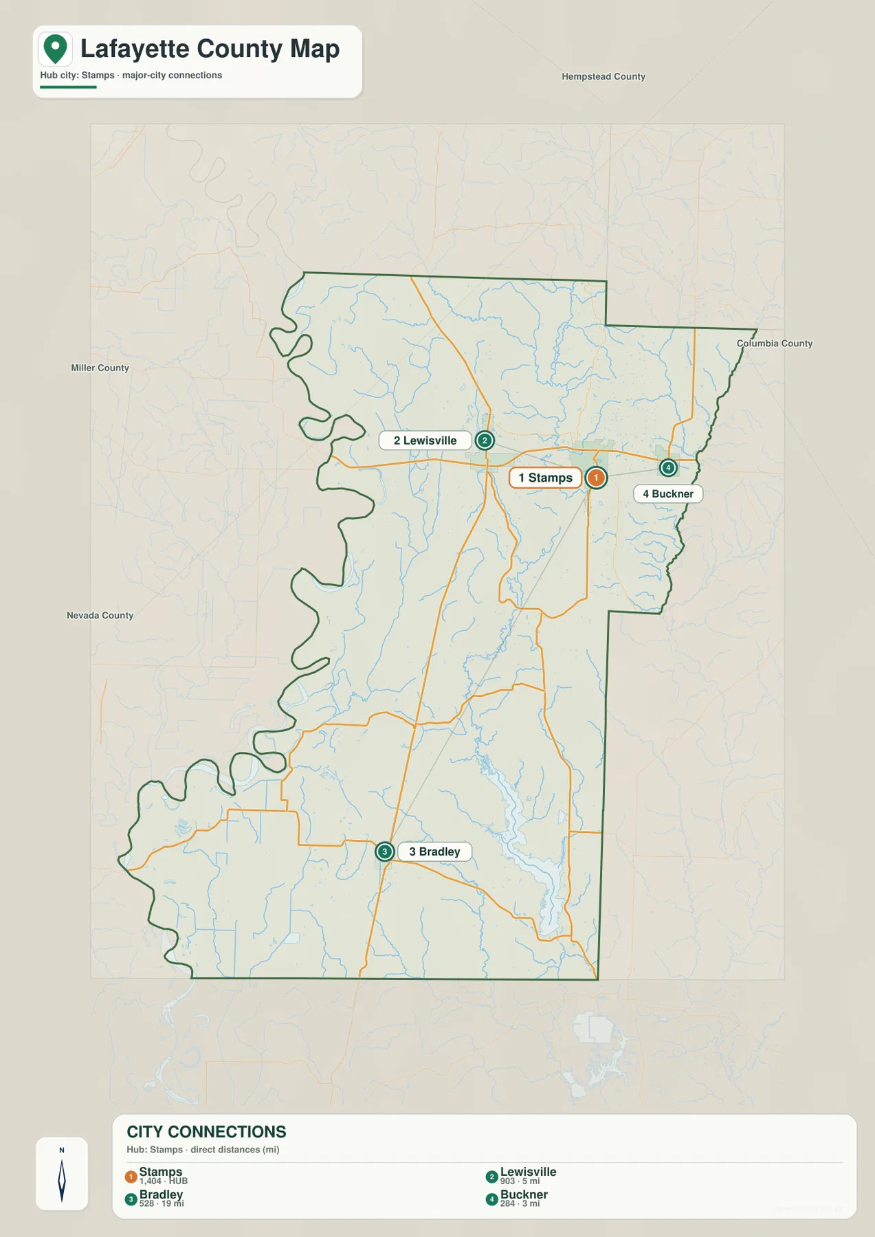
The distance pattern reinforces what the general map already suggests. Lewisville and Buckner are close enough to Stamps to form a compact northern group, all associated with the U.S. 82 corridor. Bradley is separated from that cluster by a much longer stretch of rural county and is reached by following Route 29 south. Using the city map first for scale and the general map second for actual roads gives a much clearer picture than relying on either view alone.
The legend also displays numeric values next to the city names, but this article does not treat those figures as current population statistics. The supplied map clearly supports the hub city, the three connected communities, and the straight-line distances. Lewisville’s status as county seat comes from separate county-specific reference information, while Stamps remains the map’s chosen distance hub.
Red River lowlands meet the Bodcau Creek drainage across the interior
The large river channel along the western side is the Red River, a major geographic feature of southwestern Arkansas and Lafayette County. The water map does not print the river name prominently inside the county frame, but the broad bends along the boundary match the county’s Red River setting described in county reference sources. Mays Lake, Battle Lake, and Swan Lake are clustered near this low western corridor, and Big Bayou follows another low route nearby. On the elevation map, the same area is among the lowest ground in the county.
Across the northern and central interior, the Bodcau Creek system provides another set of landmarks. Little Bodcau Creek enters from the north and descends through rolling terrain, while Bodcau Creek continues through the middle of the county. New Meriwether Pond and Meriwether Lake are labeled in the north-central area, and Lake June appears farther east. Field Bayou Ditch follows the western interior through lower ground closer to the Red River side.
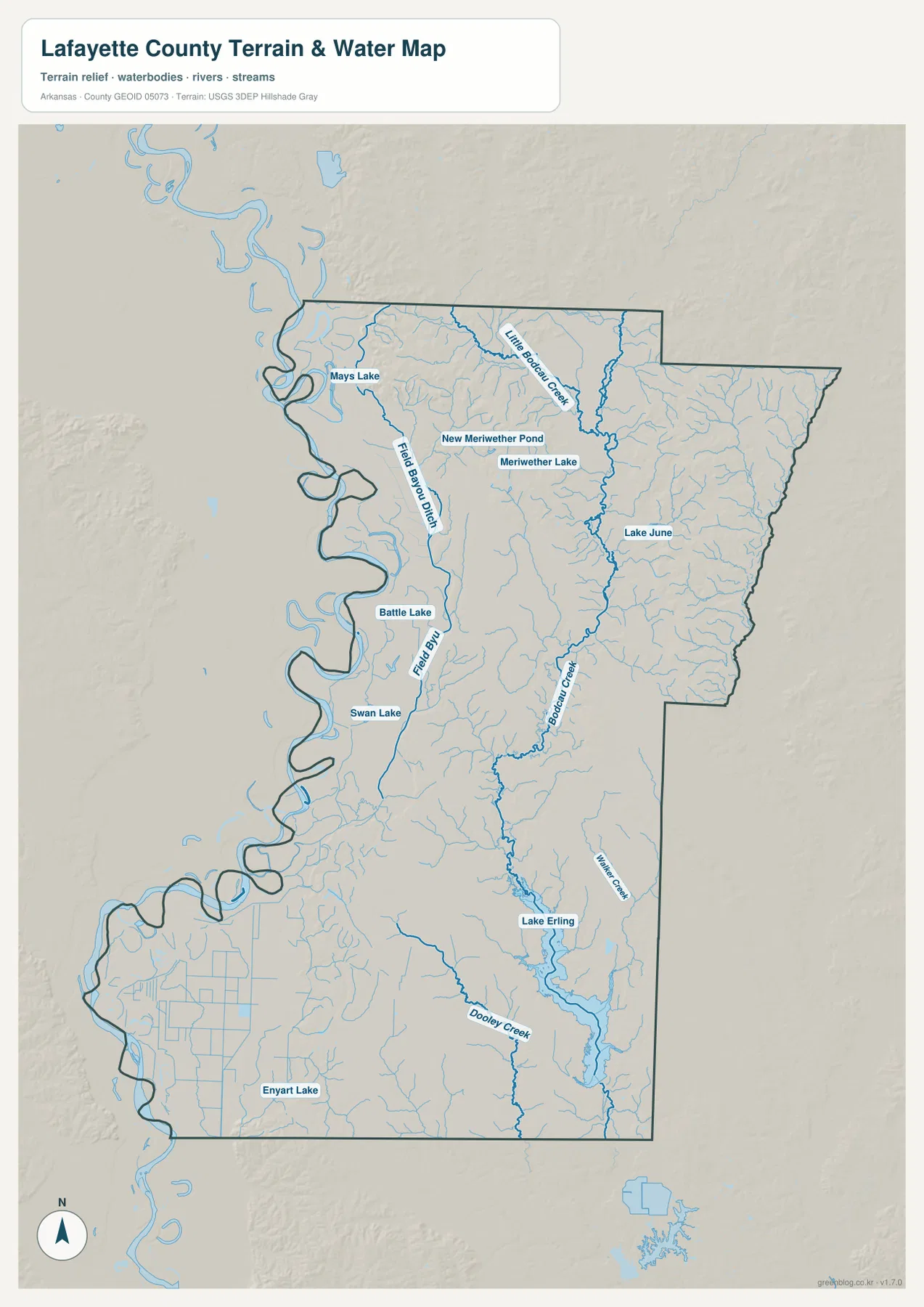
Farther south, Walker Creek and Dooley Creek run through long low valleys, and Lake Erling becomes the most prominent named lake in the southeastern part of the county. Enyart Lake is labeled in the southwest. The southern water pattern differs from the ridge-cut northern drainage: streams tend to occupy broad, gently sloping lowlands and are accompanied by many smaller channels. Comparing the water and elevation maps makes that transition especially clear.
This terrain and water map is intended for general geographic reference. It does not show current Red River stage, flood risk, Lake Erling water level, fishing regulations, property boundaries, or live road access. River and creek conditions can change with rainfall and upstream conditions. For recreation, flooding, or safety decisions, use current USGS information and guidance from the agency responsible for the specific waterway.
Elevation ranges from 54 to 121 meters, with higher ground concentrated in the north
The supplied elevation map shows an actual range of about 54 to 121 meters, with a mean near 76 meters. That is roughly 67 meters of relief across Lafayette County. The difference is modest compared with mountain counties, but the pattern is easy to see because the higher ground is concentrated in the north-central and northeastern sections. Brown and tan ridges stand above broad green lowlands along the Red River side and across much of the southwest.
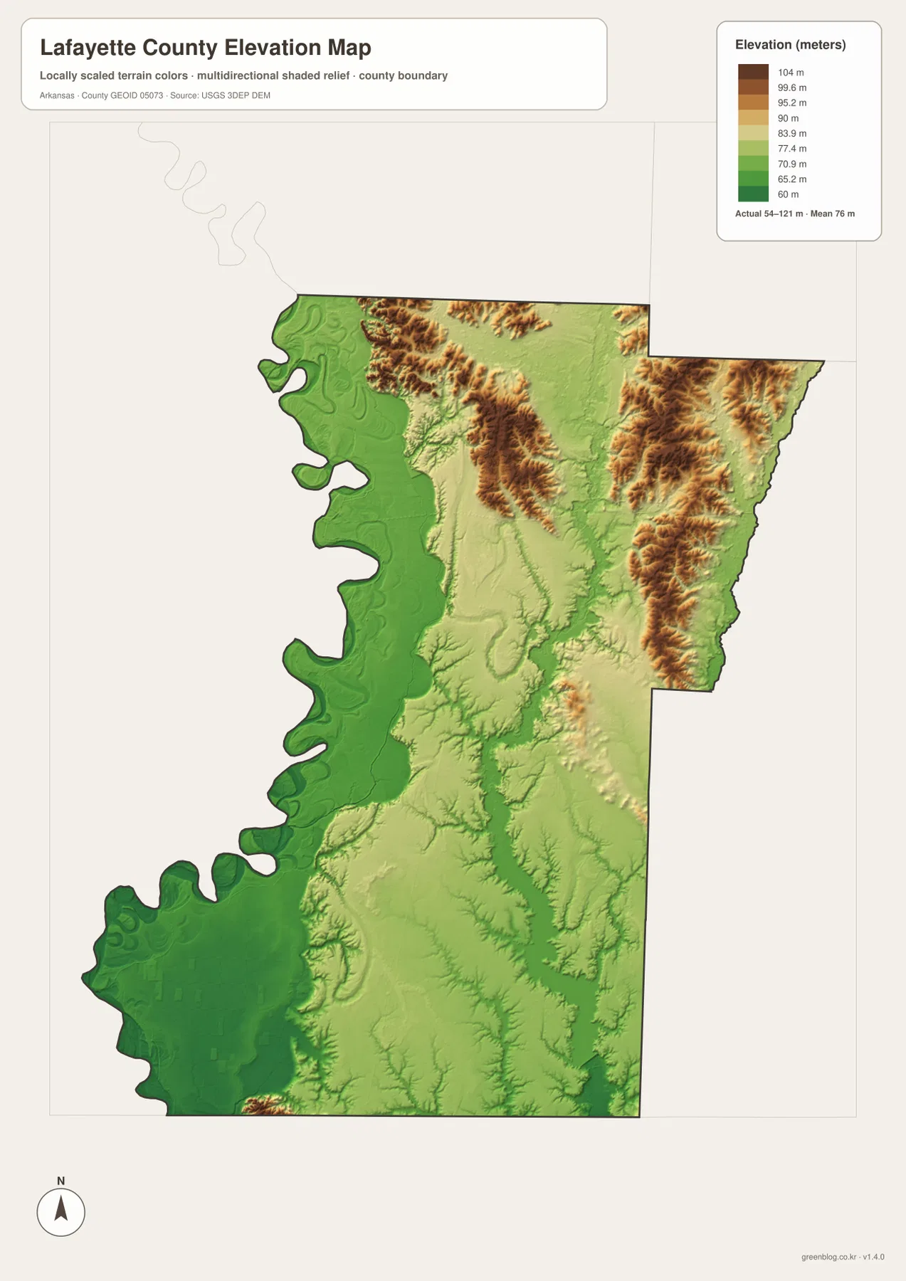
The northern high ground is not a single hill. Short ridges branch around lower creek valleys, especially near Little Bodcau Creek and the interior east of Lewisville and Stamps. Moving west from that area, elevation drops quickly toward the Red River plain. The Lewisville-Stamps corridor itself occupies more moderate terrain between the low river edge and the higher ridges farther north and east.
The southern half has gentler relief. Around Bradley and toward Lake Erling, small ridges and creek valleys remain visible, but the elevation differences are less pronounced than in the north. The southwest near the Red River is among the lowest terrain on the map. This elevation image is designed for county-scale comparison rather than survey-grade measurement, so exact heights for parcels, roads, buildings, or engineering work require original elevation data or a professional survey.
Compare the Red River side with Lake Erling from the Lewisville area
A practical way to compare the four maps is to begin around Lewisville and look in two directions. To the west, the county boundary quickly reaches the Red River’s broad bends, low ground, and small lakes such as Mays Lake and Battle Lake. To the south and southeast, Route 29 leads toward Bradley and the long lower half of the county, while Lake Erling and Walker Creek provide useful water landmarks. The two directions reveal different combinations of roads, water features, and relief.
The Stamps-Buckner side adds another contrast. Roads and communities are packed more closely together, but the north and northeast also contain higher ridges cut by Little Bodcau Creek and smaller tributaries. Switching between the general, water, and elevation maps shows how that northern road corridor sits between low river country to the west and more rolling ground to the east. Reading the same location across several maps is much easier than trying to memorize every road or creek separately.
High-resolution JPG files for Stamps roads and Red River water features
The WebP images in the article are optimized for quick page viewing. The download ZIP contains the same four maps as high-resolution JPG files, each measuring 2572 × 3638 pixels in portrait orientation. Use the general map for communities and roads, the city-connections map for direct distance and direction from Stamps, the terrain and water map for the Red River side, Bodcau Creek system, and Lake Erling, and the elevation map for comparing northern ridges with western and southwestern lowlands.
The JPG files are suitable for classroom reference, presentations, trip preparation, personal printing, and general orientation. They should not replace legal boundary records, parcel surveys, flood studies, engineering plans, or live navigation. When exact or current information is required, consult Census TIGER/Line boundaries, USGS hydrography, USGS elevation data, and the appropriate local or state source for the specific decision.
Frequently Asked Questions
Is Lewisville or Stamps the county seat?
Lewisville is the county seat of Lafayette County. Stamps is used as the hub city on the supplied city-connections map, which is a separate mapping choice. The map compares straight-line distances from Stamps, while the county courthouse is labeled in Lewisville.
What distances are shown from Stamps on the city-connections map?
The map shows about 5 miles from Stamps to Lewisville, 3 miles to Buckner, and 19 miles to Bradley. These are straight-line distances rather than driving mileage, so road distance and travel time should be checked with a current navigation map.
Where is the lowest terrain in Lafayette County?
The supplied elevation map shows the lowest terrain mainly along the western and southwestern Red River side. The countywide elevation range is about 54–121 meters with a mean near 76 meters. Higher ridges are concentrated farther north and northeast.
Map File Information
The ZIP contains the general county map, city-connections map, terrain and water map, and elevation map as high-resolution JPG files for printing or offline reference.
- File Type: ZIP containing 4 JPG files
Related Maps
Sources and references
- Encyclopedia of Arkansas – Lafayette County – county seat, Red River setting, and county background
- Encyclopedia of Arkansas – Lewisville – Lewisville and county-seat information
- Encyclopedia of Arkansas – Red River – Red River geography in southwestern Arkansas
- U.S. Census Bureau TIGER/Line Shapefiles – county boundary and road data
- USGS National Hydrography – rivers, streams, lakes, and hydrography data
- USGS 3D Elevation Program – elevation and terrain data
Green Map creates custom-edited map images using open geographic data sources such as geoBoundaries, Natural Earth, OpenStreetMap, and government open data.
These maps are edited visual materials, not raw data files, and are provided for education, documents, presentations, and graphic reference.