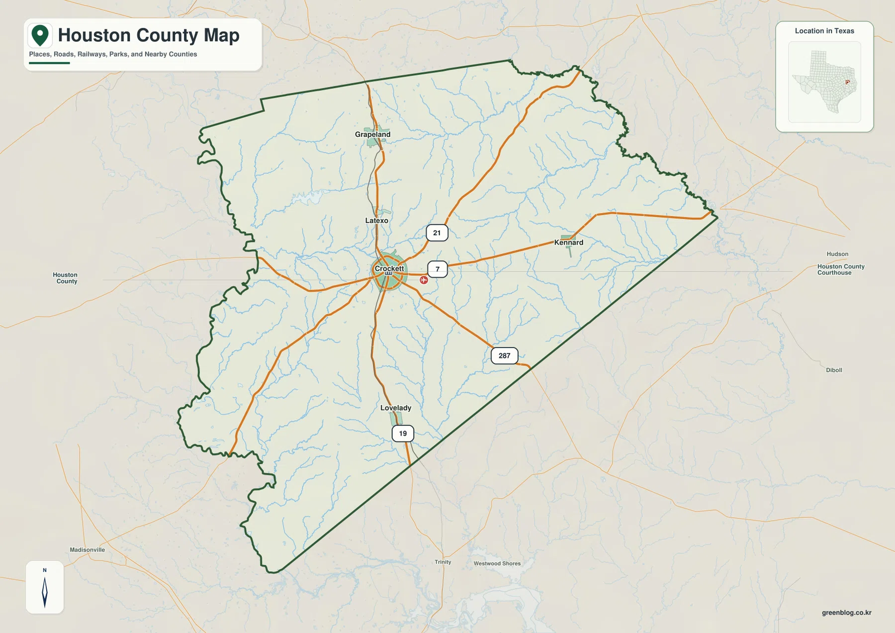
Download the map files on this page if you need a clear Houston County reference for printing, study, or local orientation. Houston County sits in East Texas, and the supplied maps make the county easiest to understand from Crockett outward. Crockett is near the middle of the county, Grapeland and Latexo are to the north, Lovelady is to the south, and Kennard lies to the east. Rather than treating those names as an isolated list, the maps show how roads, creeks, county boundaries, and changes in elevation separate and connect the communities.
The strongest geographic feature is not a single city or river but the combination of a central road hub, a dense network of small waterways, and rolling relief. The water map places the Neches River along the northeastern side and the Trinity River along the western side, while named creeks cross the interior. The elevation map ranges from about 40 to 165 meters, with an average near 93 meters, and shows higher ground concentrated more strongly across the north and northwest. High-resolution JPG versions corresponding to all four maps are available together in the download box below.
Table of Contents
Crockett gives the county map a practical center
On the county map, Crockett sits close to the center of Houston County and is the clearest place to begin reading the road pattern. Several numbered routes meet or pass near the city, then spread toward the other communities and the county boundary. Grapeland and Latexo occupy the northern part of the main settlement corridor, Lovelady is well to the south, and Kennard is east of Crockett. The result is not a continuous urban belt. Instead, the named communities are separated by long rural stretches, which makes direction and road connection more useful than simply comparing label size.
The county outline itself helps with orientation. Its western and northern sides are irregular, while a long, straighter boundary runs across the southeast. Around the outside are Anderson, Cherokee, Angelina, Trinity, Walker, Madison, and Leon counties. Seeing those neighboring names matters because roads and streams continue beyond the administrative line. A reader planning a regional trip can therefore use the boundary as a reference without mistaking it for a barrier in the real landscape.
Five mapped communities show how settlement spreads north, south, and east
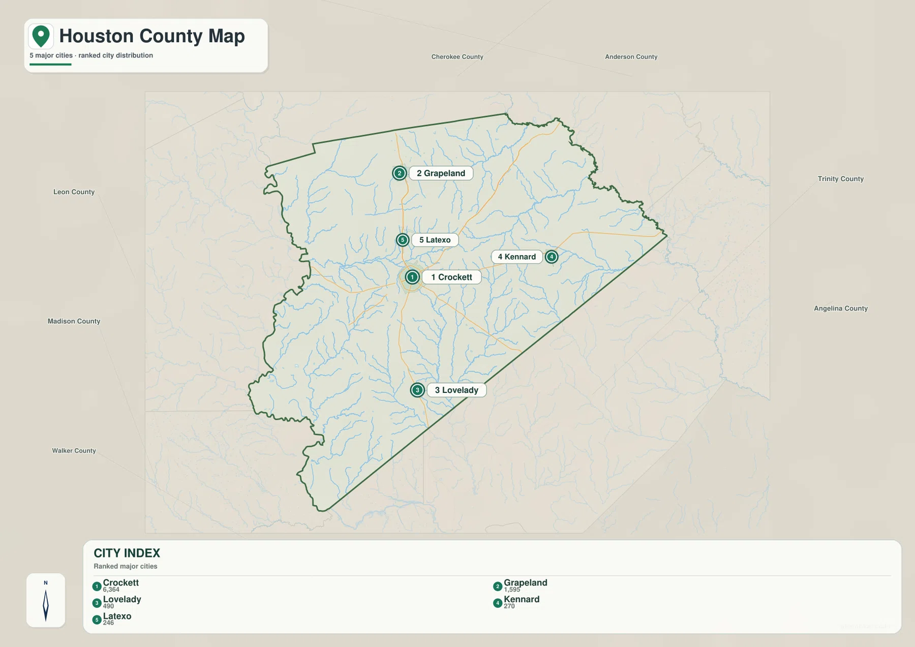
The city-distribution map ranks five communities and gives a compact picture of their relative size within the supplied dataset. Crockett is listed first at 6,364, followed by Grapeland at 1,595, Lovelady at 490, Kennard at 270, and Latexo at 246. These are the values printed on the map, so they are best used to compare the mapped communities rather than treated as a replacement for a separately dated population table. Their placement is even more useful: Grapeland and Latexo line up north of Crockett, Lovelady is distinctly south, and Kennard stands apart to the east.
That pattern makes Crockett the most convenient reference point for understanding the rest of the county. A trip toward Grapeland follows a different part of the county than a trip toward Lovelady, while Kennard represents the eastern side. Because the communities are not packed closely together, the spaces between them are part of the map story. Rural roads and creek crossings fill those gaps, and the route network becomes the practical link between settlements that otherwise look separated on the page.
The general map labels routes 21, 7, 287, and 19 around the Crockett area. Route 19 forms a strong north-south reference through the county, while 287 reaches southeast from the Crockett area and the east-west roads provide additional cross-county movement. The map is useful even without assigning every road a formal highway class: the important point is where the numbered corridors meet and which community lies along each direction. Reading the road numbers after locating Crockett makes the county much easier to navigate visually.
Between the Neches and Trinity, small creeks shape the interior
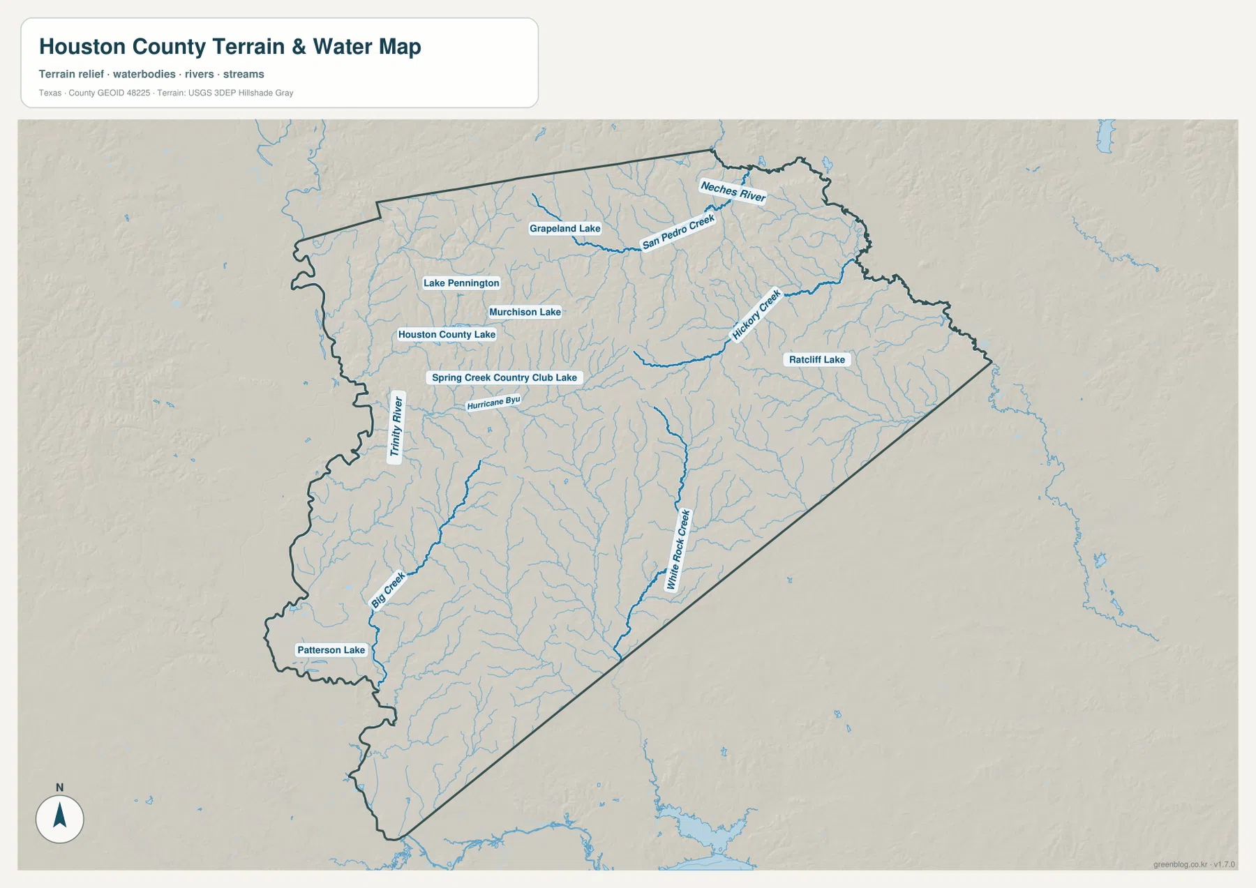
The terrain-and-water map gives Houston County a very different appearance from the road map. The Neches River is labeled along the northeastern side, while the Trinity River appears along the west. Between them is a dense branching network of smaller streams. San Pedro Creek crosses the northern part of the county, Hickory Creek is prominent farther east, White Rock Creek runs through the south-central area, and Big Creek is marked in the southwest. These waterways help explain why the interior is broken into many small drainage corridors rather than one broad, uniform surface.
Several lakes are also named on the supplied map. Grapeland Lake appears in the north, Lake Pennington and Murchison Lake lie farther west, Houston County Lake and Spring Creek Country Club Lake are shown in the west-central area, Ratcliff Lake is to the east, and Patterson Lake is near the southwest. Hurricane Bayou is another labeled water feature. The distribution is important because water is scattered across the county instead of concentrated around one dominant reservoir. Comparing this map with the settlement map shows that the towns are not simply arranged along a single river corridor.
This water map should be read as a geographic reference, not as a flood-risk, parcel, navigation, or legal-boundary product. It is most useful for seeing which streams occupy each part of the county and how frequently drainage lines cut across the landscape. For example, the eastern side near Kennard sits among a different set of creek branches than the southern area toward Lovelady. That distinction becomes clearer when the water layer is viewed together with the relief map.
Relief rises from roughly 40 meters to 165 meters
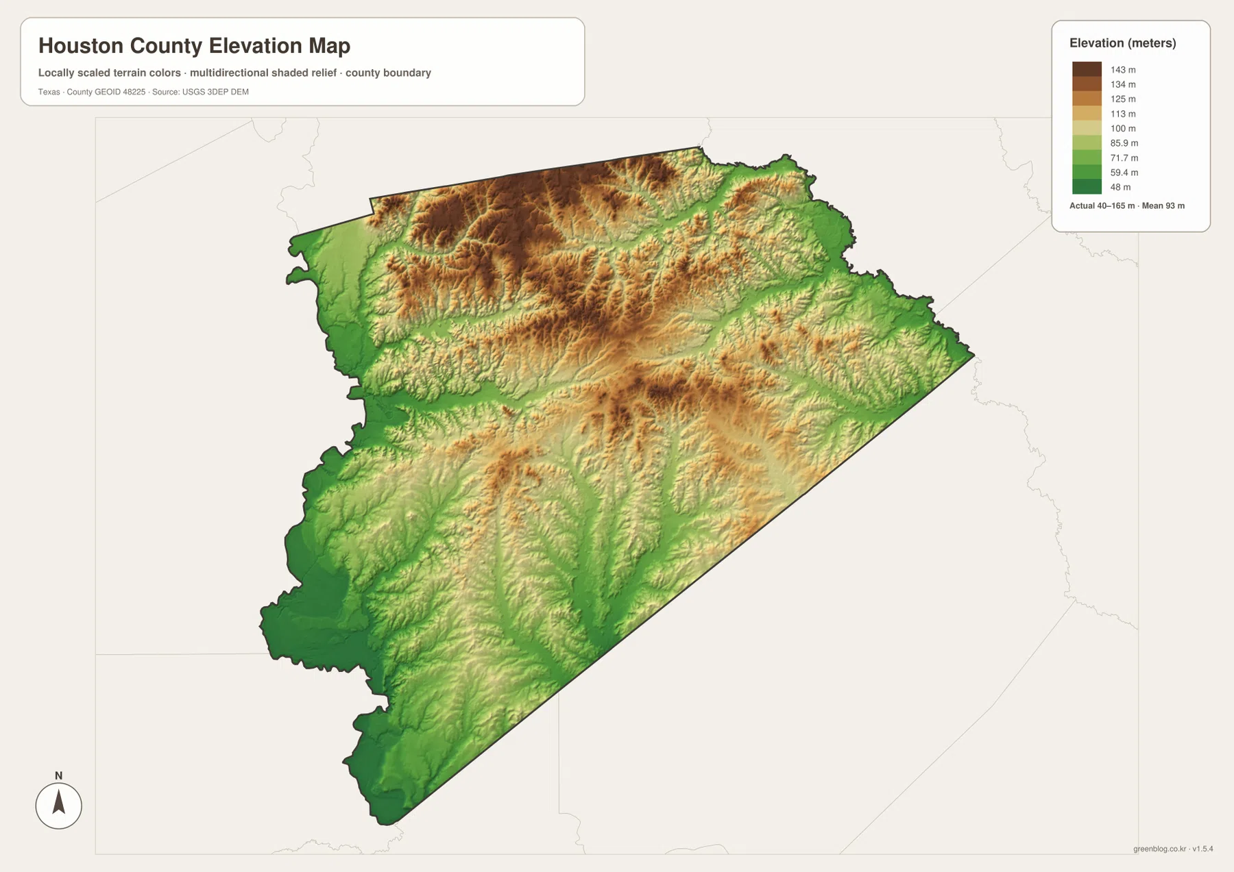
The elevation map reports an actual range of about 40 to 165 meters and a mean near 93 meters. Higher brown and tan terrain is most extensive across the north and northwest, where ridges and narrow valleys create a textured surface. Lower green areas become more common toward the southwest and along some drainage corridors. This is enough variation to make Houston County look distinctly rolling rather than flat, especially when the shaded relief is compared with the branching creeks on the water map.
The northern half contains many short ridges separated by narrow low areas, while the center also includes pockets of higher ground. Farther south, lower terrain becomes broader in places, though ridges continue to cross the county. The western lowlands make sense beside the Trinity River reference, and the northeastern edge also drops toward the Neches River. The relationship between elevation and drainage is therefore more informative than the minimum and maximum numbers alone: the map shows where water has a lower path through otherwise rolling ground.
For classroom work, general route planning, or regional comparison, this generalized surface is a useful way to understand the county. It is not survey-grade elevation and should not be used to determine the exact height of a property, engineering point, or legal boundary. A better use is to compare broad high and low zones, then switch to the water map to see which valleys contain named creeks. That two-map comparison is one of the clearest ways to understand the physical shape of Houston County.
The neighboring counties make the boundary easier to understand
Houston County is easier to place within East Texas when the surrounding counties remain visible. Anderson and Cherokee counties sit to the north and northeast, Angelina and Trinity counties are on the eastern and southeastern side, and Walker, Madison, and Leon counties are toward the west and southwest. Those names turn the boundary from an abstract outline into a regional locator. A road leaving Crockett can be understood not only as a line toward the edge of the map, but as a connection to another county and another group of communities.
The same is true for natural features. The Neches and Trinity systems extend beyond Houston County, so their importance cannot be understood by stopping at the county line. Smaller creeks also continue into a larger drainage network. For readers comparing multiple county maps, keeping the neighboring labels in view helps explain why similar terrain or stream patterns continue across an administrative border. It also makes the long southeastern boundary and the more irregular western side easier to recognize when switching between maps.
Choose the map by the question you need to answer
Use the general county map when the priority is a quick combination of boundary, towns, and numbered roads. Use the city-distribution map when the question is where the main communities sit relative to Crockett and one another. The water map is the better choice for tracing the Neches and Trinity sides of the county, finding named creeks, or comparing lakes. The elevation map is most useful when the difference between northern ridges, creek valleys, and lower southwestern terrain matters.
For a printed worksheet or presentation, selecting one or two maps is often clearer than trying to combine every layer. A road-and-town exercise can use the general and city maps, while a physical-geography exercise can pair the water and elevation maps. The four JPG files in the archive correspond to the four map views shown on this page, so the same geographic references remain available at higher resolution for offline use.
Frequently Asked Questions
Where should I start when reading the Houston County map?
Start with Crockett because it lies near the middle of the county and several numbered roads meet around it. From there, place Grapeland and Latexo to the north, Lovelady to the south, and Kennard to the east, then use the county boundary as a wider reference. This sequence makes the layout easier to understand without treating the communities as an isolated list.
Does the Neches River tell the whole water story of Houston County?
No. The Neches River is an important northeastern reference, but the Trinity River also appears on the western side and many named creeks cross the interior. Looking at smaller waterways and scattered lakes together gives a much better picture of how water is divided between the two larger river systems.
What stands out most on the Houston County elevation map?
The clearest contrast is between higher ground in the north and northwest and lower terrain toward the southwest and along creek valleys. The map reports roughly 40 to 165 meters of elevation with a mean near 93 meters. It is intended for regional terrain reference rather than precise surveying or engineering measurements.
Sources and Reference Data
The article is based primarily on the supplied Houston County maps and package materials. The official resources below are useful for checking the underlying categories of geographic information, including county boundaries, hydrography, and elevation.
- U.S. Census Bureau TIGER/Line Shapefiles — official geographic boundary and line data.
- USGS National Hydrography — official information for rivers, streams, and water features.
- USGS 3D Elevation Program — elevation data and 3DEP program information.
- USGS The National Map Viewer — a viewer for multiple official U.S. geographic layers.
Map File Information
Download the high-resolution JPG files that correspond to the county, city-distribution, water, and elevation maps shown on this page.
- Included Files: Four Houston County map images
- File Type: JPG
Related Maps
- Anderson County Texas map
- Angelina County Texas map
- Trinity County Texas map
- Walker County Texas map
- Nacogdoches County Texas map
Green Map creates custom-edited map images using open geographic data sources such as geoBoundaries, Natural Earth, OpenStreetMap, and government open data.
These maps are edited visual materials, not raw data files, and are provided for education, documents, presentations, and graphic reference.