This page uses Groveton as the central road reference for a Trinity County Texas Map, then compares the larger town of Trinity in the southwest, the Neches River along the eastern side, and a network of creeks and small lakes across the county. Download the high-resolution A3 JPG map ZIP from the box below when you need printable or editable files; it contains separate county-reference, ranked-city, terrain-and-water, and elevation maps.
Trinity County is not dominated by one large urban center. Groveton sits closer to the middle of the county and works well as a road anchor, while Trinity lies much farther southwest. Between them and across the northern interior, numerous creeks cut through rolling terrain. The elevation map shows the highest ground in the central-western and central-southern interior, while the southwest near Trinity and the eastern Neches River side are distinctly lower.
Table of Contents
Groveton organizes the road map while Trinity anchors the southwest
Groveton is the easiest place to locate first on the county reference map. Route 287 approaches from the northwest toward the central part of the county, and route 94 extends northeast from the Groveton area. On the southwestern side, route 19 is the clearest numbered reference near Trinity. Those three route labels make it possible to orient the county quickly without treating every orange road line as equally important.
Trinity lies southwest of Groveton and is accompanied by nearby labels such as Mill Town and Westwood Shores. Riverside appears farther south near the county edge. These places create a useful sequence for the lower southwestern part of the map, while Groveton remains the better reference for traveling toward the northeast and the wider interior. The difference between the two town locations becomes especially useful when the road map is compared with the water and elevation layers.
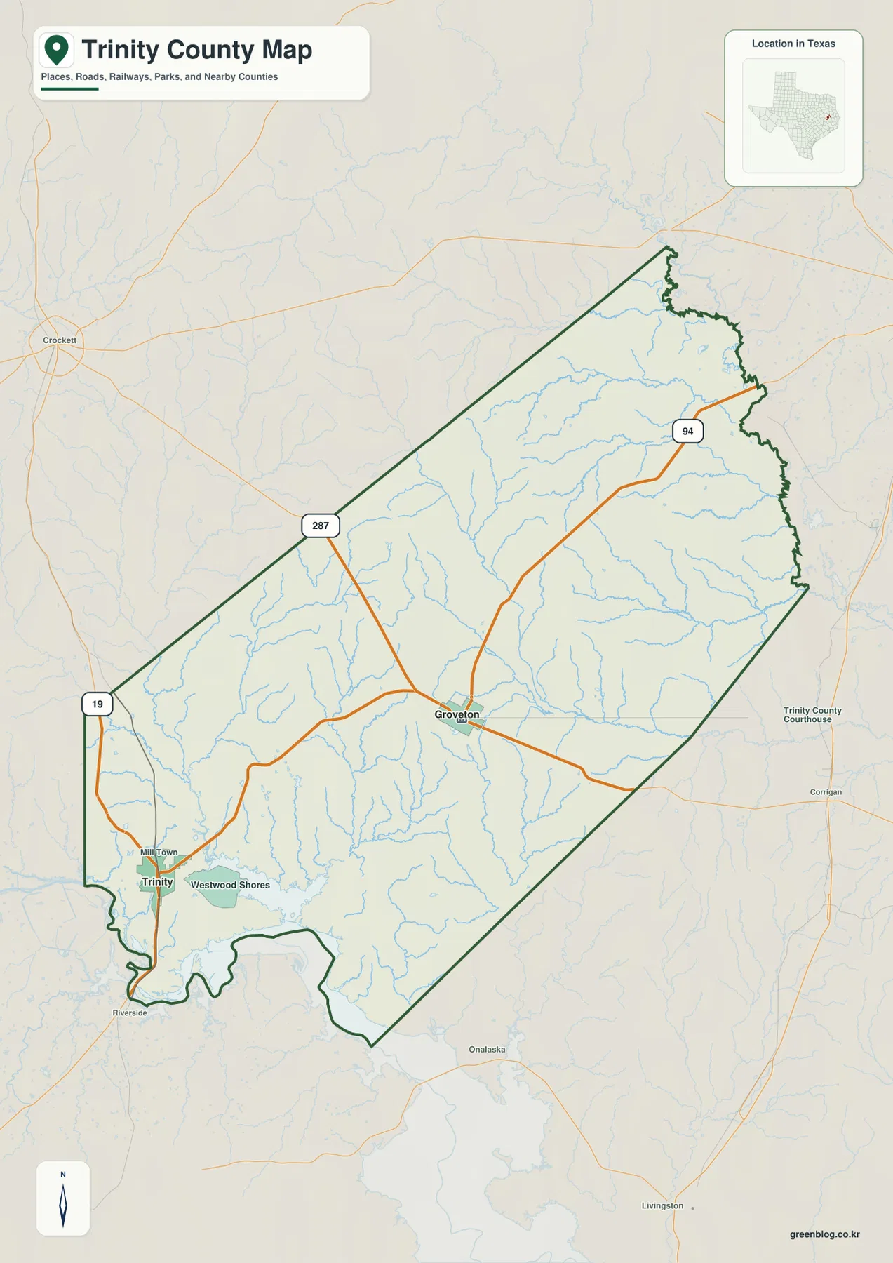
The blue drainage lines are unusually prominent compared with the sparse settlement labels. Streams branch repeatedly across the interior, especially north and east of Groveton, while the southwest around Trinity also contains low creek corridors and lake areas. This makes the reference layer useful for more than road orientation: it already suggests a landscape of rolling uplands separated by many narrow valleys.
The ranked city map compares Trinity and Groveton directly
The city map highlights only two major mapped communities. Trinity is number 1 in the southwest, and Groveton is number 2 nearer the central part of the county. Because the two points are widely separated, the simplified map makes it clear that the county’s main settlements do not form one compact cluster. Large rural areas and creek networks occupy the space between them.
The CITY INDEX prints map values of 2,258 for Trinity and 924 for Groveton. Those values explain the ranking used in the supplied graphic and should be treated as map values rather than guaranteed current population estimates. Anyone needing current demographics should consult an official statistical source. For geographic reading, the useful information is the relative size and position of the two communities.
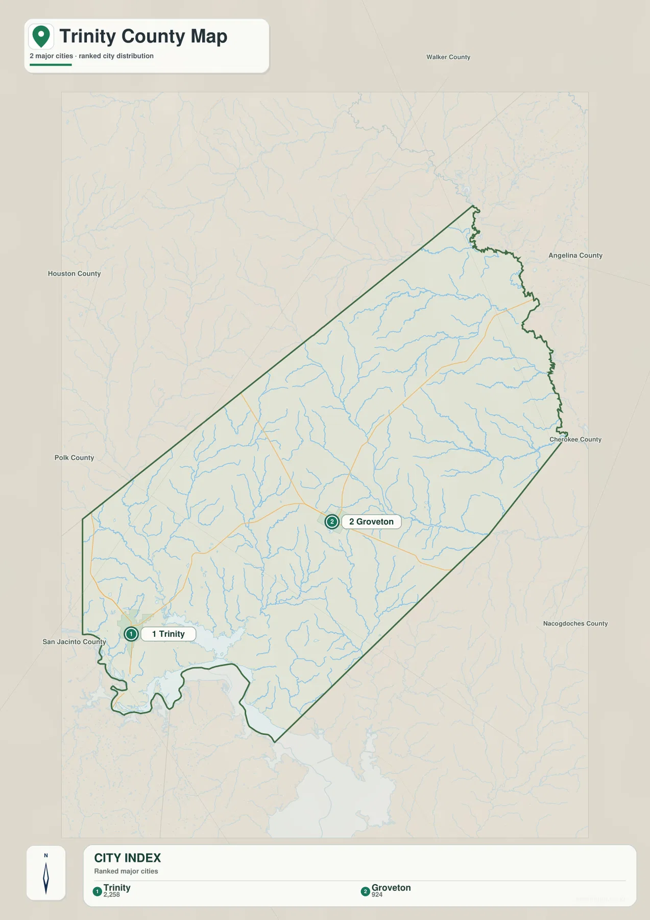
The neighboring county labels help place those towns in a larger regional frame. Walker County is north, Houston County lies to the northwest, and Polk County is on the western side. Angelina and Cherokee counties appear to the east and northeast, Nacogdoches County is southeast, and San Jacinto County is southwest. Trinity therefore sits closer to the lower southwestern edge, while Groveton occupies a more central location within the county.
Piney Creek crosses the interior toward the Neches River side
The terrain-and-water map is easiest to organize by starting with the Neches River along the northeastern and eastern boundary. Sandy Creek and North Creek occupy nearby valleys, and Alabama Creek forms another strong east-central drainage line. These channels help explain why the eastern edge of the elevation map contains broad low green terrain rather than the higher brown uplands seen farther west.
Piney Creek is one of the longest and most useful named interior channels. It runs through the central part of the county toward the southeast and receives many smaller tributaries. Lake Pennington sits farther northwest, while Avery Lake and Rice Lake are closer to the central-southern interior. These small water bodies give the otherwise creek-dominated middle of the county several easy reference points.
The southwest has a different set of water landmarks. Caney Creek forms a strong drainage line, with Little White Rock Creek farther west. Cameron Lake lies near that system, and Lake Jennifer and Sentell Lake appear closer to the southwestern edge. Westwood Shores Lake is the largest clearly labeled lake reference near the Trinity and Westwood Shores area, connecting the settlement map to the lower water-rich terrain in the southwest.
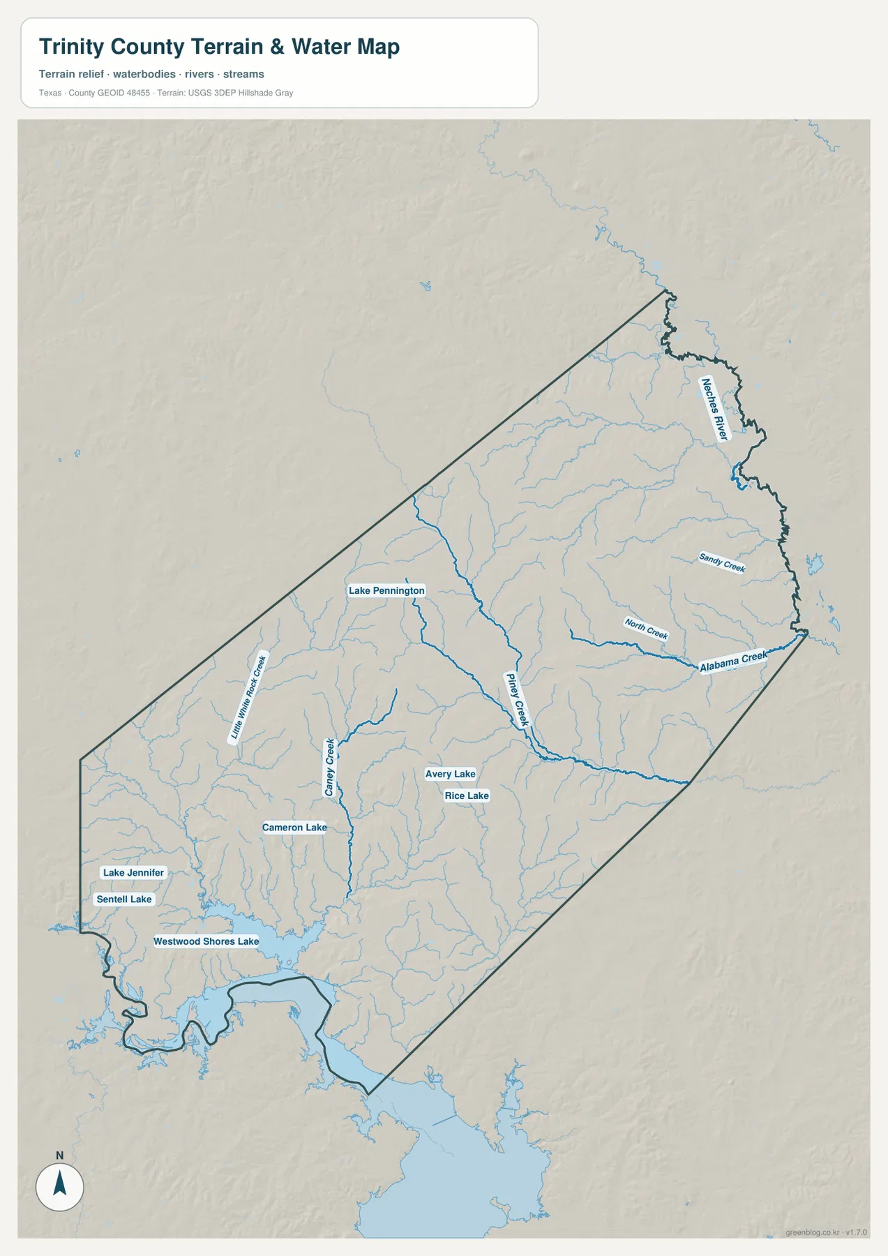
This layer is intended for geographic water and terrain reference rather than flood-risk analysis, parcel boundaries, navigation, water depth, or lake-management decisions. Its main value here is to show how the central creek network relates to Groveton, how the Neches River defines the eastern side, and why the Trinity area in the southwest appears lower and more water-oriented.
Central uplands rise above the southwest and eastern river lowlands
The elevation map reports an actual range of about 40 to 130 meters and a mean elevation of 76 meters. The strongest brown high ground is concentrated in the central-western interior and another elevated belt runs through the central-southern part of the county. Higher ridges also appear near the northwestern boundary. In contrast, the southwest and much of the eastern edge are predominantly green and therefore much lower.
The high ground is broken rather than continuous. Piney Creek and Caney Creek occupy lower valleys between the central ridges, and the southwestern lake area sits within broad low terrain. Along the Neches River side, lower elevations extend for long stretches, although small ridges remain between tributaries. The result is a county of rolling uplands separated by repeated creek corridors rather than a simple west-to-east slope.
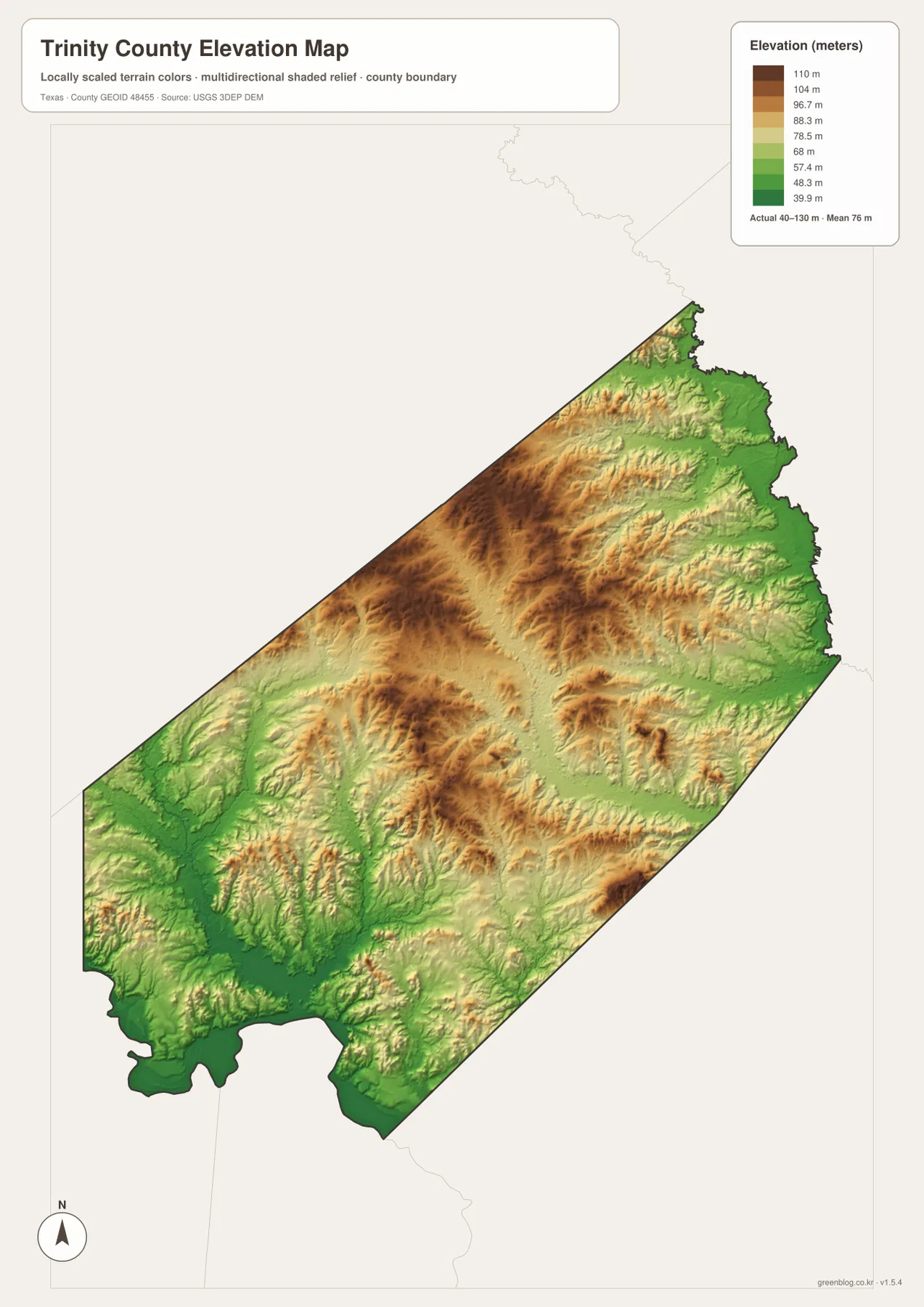
This countywide elevation surface is designed for broad terrain comparison rather than parcel surveying, engineering, or construction design. It is useful for seeing why the central interior looks more rugged, where Piney Creek and other tributaries cut through the uplands, and how the Trinity and Neches River sides occupy lower ground. Exact site elevation should be checked with detailed source data or a local survey.
Choose the view by whether roads, towns, creeks, or relief matters most
Use the county reference map when Groveton, Trinity, route labels, smaller communities, and the county boundary need to appear together. The ranked city view is cleaner for comparing only Trinity and Groveton. The terrain-and-water layer is the best place to trace Neches River, Piney Creek, Alabama Creek, Lake Pennington, and the southwestern lake group, while the elevation map makes the central uplands and lower eastern and southwestern terrain easiest to compare.
The downloadable ZIP contains four separate high-resolution A3 JPG files for Trinity County: county reference, ranked city, terrain and water, and elevation. You can inspect the lighter WebP versions in the article first and then use the larger JPG files for printing, classroom material, presentations, or an editable local-reference document.
Frequently Asked Questions
Where is Trinity compared with Groveton?
Trinity is southwest of Groveton on the supplied maps. Route 19 is the clearest numbered road reference near Trinity, while Groveton is closer to routes 287 and 94.
Where does the Neches River border Trinity County?
The terrain-and-water map shows the Neches River along the northeastern and eastern side of the county. That river corridor also appears as generally lower terrain on the elevation map.
What elevation range is shown for Trinity County?
The supplied elevation map states an actual range of about 40 to 130 meters and a mean elevation of 76 meters. The central-western and central-southern interior is higher, while the southwest and eastern edge are lower.
Map File Information
The ZIP contains the four Trinity County maps in high-resolution A3 JPG format.
- Included Versions: County reference, ranked city, terrain and water, elevation
- Included Files: 4 A3 JPG maps
Related Maps
Sources and data references
Roads, settlement locations, and the Trinity County boundary can be cross-checked with the U.S. Census Bureau TIGER/Line Shapefiles. Neches River, Piney Creek, Alabama Creek, lakes, and other named drainage features can be checked against USGS National Hydrography, while terrain height data are available through the USGS 3D Elevation Program. City index values, route references, named waters, and the 40–130 meter elevation range described above are based on the Trinity County maps supplied in this package.
Green Map creates custom-edited map images using open geographic data sources such as geoBoundaries, Natural Earth, OpenStreetMap, and government open data.
These maps are edited visual materials, not raw data files, and are provided for education, documents, presentations, and graphic reference.