Download the Hopkins County Texas Map set as high-resolution JPG files for printing, study, or offline reference. The page also provides web previews that place Sulphur Springs near the center of the county’s road network, with Cumby to the west, Como to the southeast, and Tira to the north. Separate county, city-connection, water-and-terrain, and elevation maps make it easier to compare roads, settlements, creeks, lakes, and changes in terrain without forcing all of that information into a single crowded view.
A useful way to understand Hopkins County is to begin with Sulphur Springs, then move outward along the major roads and compare those routes with the waterways and elevation. I-30 provides the clearest east-west corridor, while state highways extend north and south from the central area. The northern boundary is noticeably irregular, the western side includes higher terrain, and the eastern side contains broader areas of lower elevation. Looking at the maps in combination makes those contrasts much easier to recognize.
Table of Contents
Sulphur Springs at the center of the county layout
The general county map places Sulphur Springs close to the middle of Hopkins County and shows how several major roads converge around it. Cumby appears near the western boundary, Como is southeast of Sulphur Springs, and Tira is north of the county seat. Outside the county, labels such as Commerce to the west, Mount Vernon to the east, and Winnsboro to the southeast provide additional orientation and make it easier to see how Hopkins County fits among nearby communities.
The boundary itself is also worth noticing. Much of the southern edge is comparatively straight, while the northern edge bends and curves for a long distance. That irregular northern outline sits beside a landscape with many small drainage channels, so the water and terrain maps add useful context that is not obvious from the boundary line alone.
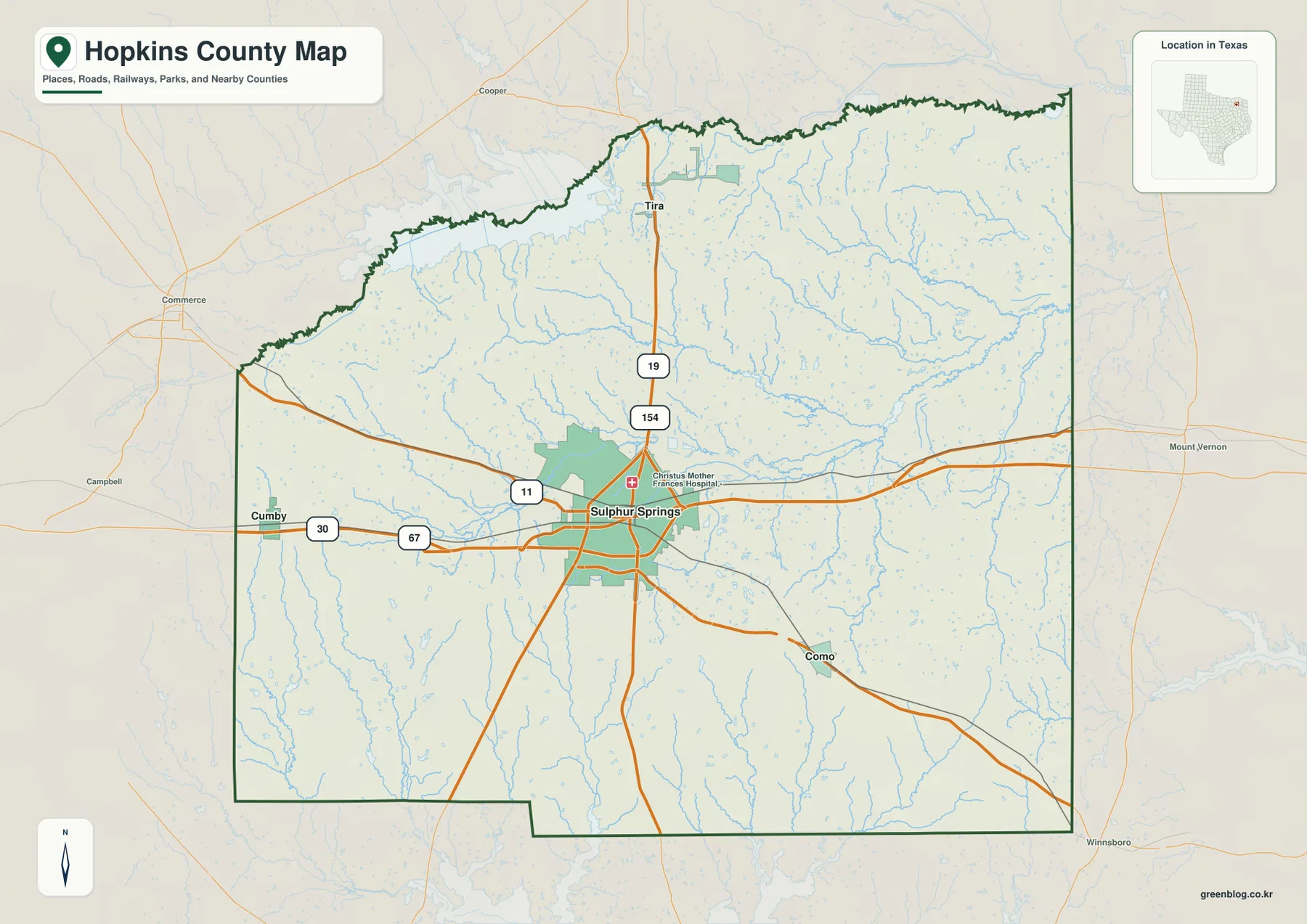
I-30 crosses the western and central part of the county, passing Cumby and continuing through the Sulphur Springs area before heading east. US 67 also approaches the central area from the west, while State Highways 11, 19, and 154 add important connections in other directions. This road pattern makes Sulphur Springs the easiest reference point for understanding both local movement and travel beyond the county.
The map also shows a denser street pattern around Sulphur Springs than in the surrounding rural areas. Instead of treating every small road as equally important, it is more useful to identify I-30 and the numbered highways first, then use them to locate the smaller communities and water features. That sequence gives the county a clear structure without turning the map into a list of road names.
Cumby, Como and Tira form three distinct directions from Sulphur Springs
The city-connections map simplifies the county around four labeled communities. Sulphur Springs is the hub, Cumby is west, Como is southeast, and Tira is north. Because those three smaller communities spread in different directions rather than following one straight corridor, the map quickly shows that local settlement is organized around a central town with separate western, northern, and southeastern branches.
The distances printed on this map are direct, straight-line distances rather than driving distances. Cumby is shown at about 14 miles from Sulphur Springs, Como at about 9 miles, and Tira at about 12 miles. Actual road travel will be longer or shorter depending on the route used, so the figures are best treated as a quick comparison of relative separation rather than a trip-planning mileage table.
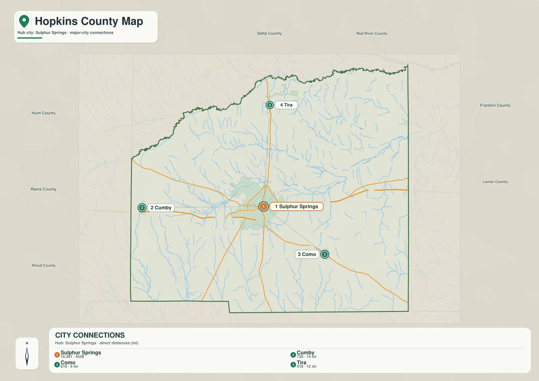
Cumby’s position aligns closely with the I-30 and US 67 corridor on the western side. Como is connected with the southeastern road pattern, while Tira lies along the northward route associated with Highways 19 and 154. Those differences are useful when preparing classroom maps, regional orientation sheets, or simple travel references because the communities can be understood by direction as well as by name.
The supplied existing material describes Sulphur Springs as the county’s main service center and notes a local economy connected with dairy history, cattle, manufacturing, distribution, retail, health care, and highway services. The maps do not show the locations or size of those activities in detail, but that background helps explain why the road network becomes more concentrated around Sulphur Springs than around the smaller communities.
South Sulphur River, local creeks and a chain of small lakes
The water-and-terrain map reveals one of the most distinctive features of Hopkins County: a dense network of streams crossing much of the county. South Sulphur River is labeled near the northwestern boundary, while North Caney Creek, White Oak Creek, and Rock Creek appear farther inside the county. Numerous smaller tributaries branch from these named waterways, especially across the northern and central portions.
Several lakes are also labeled around and south of Sulphur Springs. Lake Sulphur Springs and Century Lake sit close to the central area, with Lake Coleman and Helm Lake farther south. Crush Lake and Alberta Lake are shown in the southern half of the county. Rather than one dominant reservoir occupying a large part of Hopkins County, the map shows multiple smaller water bodies distributed among many creeks.
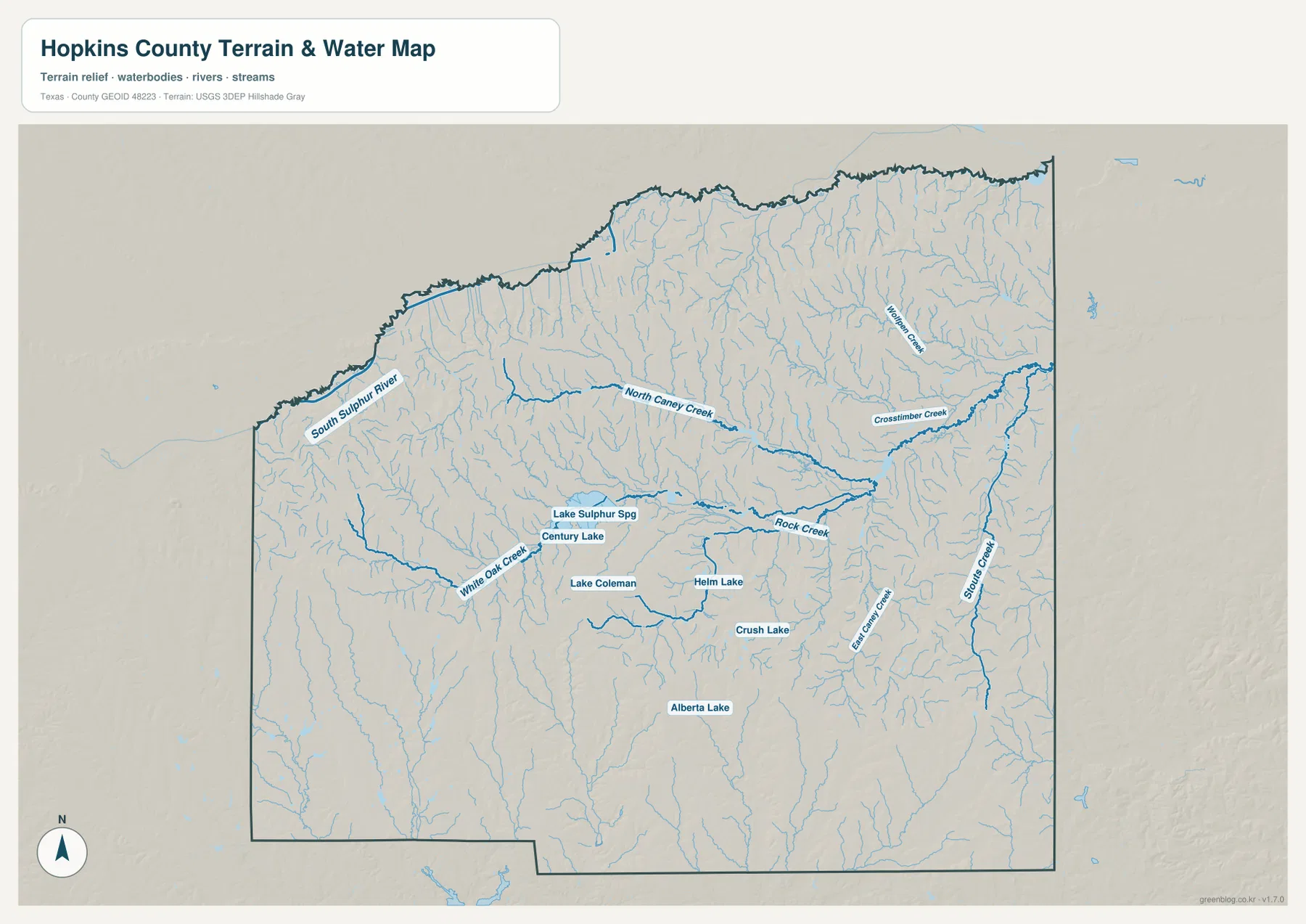
This map is intended as a geographic reference to the visible rivers, creeks, lakes, and terrain. It should not be used as a flood-risk map, a parcel or legal-boundary product, or a navigation chart. Its main value is in showing where water features are concentrated, which roads cross them, and how the central lakes relate to Sulphur Springs and the surrounding countryside.
Comparing the general map with the water map is especially helpful around I-30 and Sulphur Springs because several small drainage lines cross the developed road network. Farther north, tributaries become visually denser and the boundary is more irregular. To the south, long creek lines continue through less densely settled areas. Those contrasts explain the county more clearly than a generic description of northeast Texas terrain would.
Higher western ridges and lower ground toward the east
The elevation map shows an actual mapped range of approximately 102 to 199 meters, with a mean elevation of about 146 meters. The western and southwestern parts contain broad areas of brown and tan, indicating relatively higher ground. Green tones become more common toward the east and northeast, where lower elevations occupy larger connected areas.
The western side is not simply a flat high platform. The shaded relief shows many short ridges and valleys, creating a textured surface with repeated rises and depressions. Central and southeastern areas also contain locally higher ridges, so the county does not decline evenly from west to east. A practical reading is to notice the broad west-to-east contrast first and then look at the smaller ridges that interrupt that pattern.
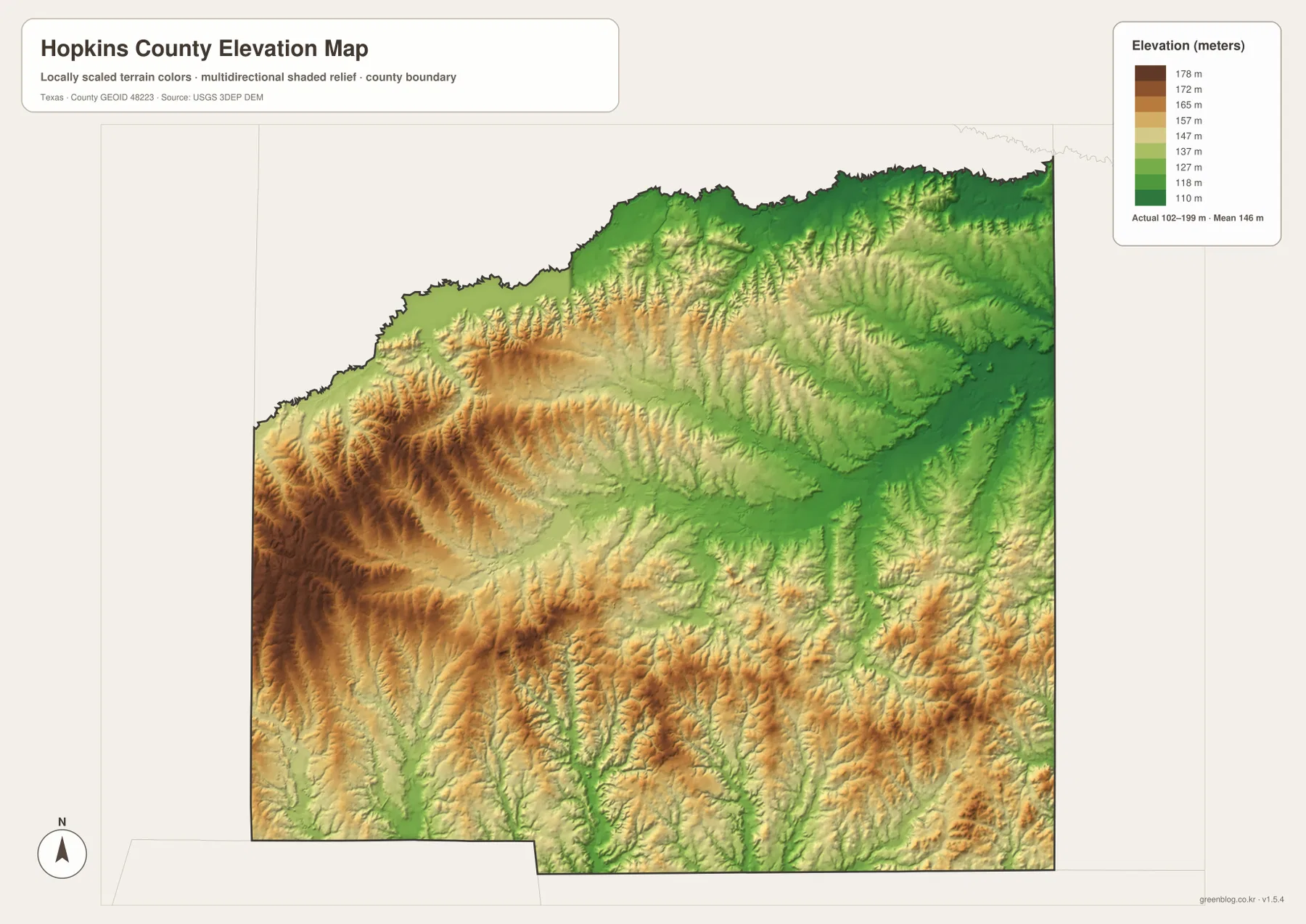
The elevation and water maps complement each other. Many drainage lines occupy lower corridors between ridges, so some of the branching pattern on the water map makes more sense after looking at the shaded relief. The elevation surface is generalized for county-scale interpretation, however, and it is not survey-grade data for construction, engineering, drainage design, or property-level elevation decisions.
For educational use, exact elevation numbers are less important than the overall contrast. Students can compare the higher western terrain, the lower east, the irregular northern boundary, and the central position of Sulphur Springs. That combination gives a more complete picture of the county than treating roads, settlements, water, and relief as unrelated subjects.
Which Hopkins County map works best for your purpose?
Use the general county map when you need the quickest overview of the boundary, Sulphur Springs, surrounding communities, and the major highway pattern. Choose the city-connections map when the main question is the direction and relative distance of Cumby, Como, or Tira from the county seat. The water-and-terrain map is the better choice for creeks and lakes, while the elevation map is designed to show differences in height and the shape of ridges and valleys.
For a classroom handout, a useful sequence is to begin with the county map so readers can establish location and transportation, then add the water or elevation map according to the lesson. For a field visit, the same overview can help with orientation before a more detailed road source is consulted. If the subject is specifically Lake Sulphur Springs, South Sulphur River, or the county’s relief, starting with the specialized map avoids unnecessary detail from the other layers.
The four files describe the same county but are not interchangeable. Place names and highways are easiest to read on the general map, straight-line city relationships are clearest on the connection map, named waterways stand out on the water map, and terrain height is the focus of the elevation map. Selecting the file that matches the question usually produces a cleaner printout and a more useful reference.
Reading Hopkins County with its neighboring counties
The city map labels Hunt and Rains counties to the west and southwest, Delta and Red River counties to the north, Franklin County to the east, Lamar County toward the northeast, and Wood County to the south. Those labels matter because roads, streams, and day-to-day travel do not stop visually at the Hopkins County boundary. They help show why Sulphur Springs can be central within the county while still being part of a wider northeast Texas network.
The general map adds nearby places outside the boundary, including Commerce, Mount Vernon, and Winnsboro. Their positions provide useful reference points when someone is unfamiliar with the county itself. Rather than interpreting the county as an isolated shape, it can be placed between recognizable communities and along the I-30 corridor, with water systems continuing across administrative lines.
Preparing the maps for printing or offline use
The preview images on this page are WebP files intended for efficient viewing on the web. The download package contains the corresponding high-resolution JPG versions, with separate files for the county map, city-connections map, water-and-terrain map, and elevation map. Keeping the maps as separate files makes it easy to print only the layer you need or place different maps on separate pages of a report or presentation.
For printing, it is usually better to insert the original JPG into the document and scale it down to the page rather than enlarging a smaller screenshot. That approach preserves labels and linework more clearly. If you plan to annotate a map, keep an untouched original and work on a copy so the high-resolution source remains available for another use.
Frequently Asked Questions
What is the easiest place to locate first on a Hopkins County map?
Start with Sulphur Springs. It sits close to the center of the county and is the point where the major road pattern is easiest to recognize. From there, Cumby is west, Como is southeast, and Tira is north, giving you three clear directions for understanding the rest of the county.
Can Lake Sulphur Springs and South Sulphur River be seen on the same map?
Yes. Both are labeled on the water-and-terrain map, but they occupy different parts of the county. Lake Sulphur Springs is close to the central Sulphur Springs area, while South Sulphur River appears near the northwestern boundary. The shared word “Sulphur” does not mean they are the same feature.
Are the 102–199 meter elevations suitable for engineering or property surveys?
No. The elevation map is a county-scale visual reference designed to show broad differences in height and relief. It is useful for comparing the higher western terrain with lower areas to the east, but engineering, construction, drainage, or property decisions require the original elevation data and appropriate field or survey measurements.
Sources and reference links
Boundary and geographic line data can be checked through the U.S. Census Bureau TIGER/Line Shapefiles. Official hydrography information is available from USGS National Hydrography, while elevation source information is available through the USGS 3D Elevation Program. For an interactive view of national map layers, see the USGS The National Map Viewer.
Map File Information
Download high-resolution JPG files for the Hopkins County general map, city-connections map, water-and-terrain map, and elevation map.
- Included Files: County map, city-connections map, water-and-terrain map, elevation map
- File Type: JPG
Related Maps
- Rains County Texas map
- Wood County Texas map
- Red River County Texas map
- Titus County Texas map
- Rockwall County Texas map
Green Map creates custom-edited map images using open geographic data sources such as geoBoundaries, Natural Earth, OpenStreetMap, and government open data.
These maps are edited visual materials, not raw data files, and are provided for education, documents, presentations, and graphic reference.