Butler County, Kentucky is easiest to understand by starting with two names: Morgantown and the Green River. Morgantown sits near the middle of the county and serves as the clearest reference point for the road network, while the river bends through the central and western landscape toward Rochester. Woodbury lies much closer to Morgantown on the eastern side. Together, those places provide a simple framework for locating roads, waterways, and the rolling terrain shown across the county. High-resolution map files are available for download in the section below.
The maps on this page can be viewed online and downloaded as high-resolution JPG files for printing or offline use. The set includes a county reference map with roads and neighboring counties, a simplified city-connections map, a water map with named rivers and creeks, and an elevation map showing relative height across Butler County. These files work well for classroom material, local orientation, and general geographic reference, but they are not substitutes for current parcel, flood, engineering, or traffic data.
Table of Contents
Morgantown provides the clearest starting point for roads and communities
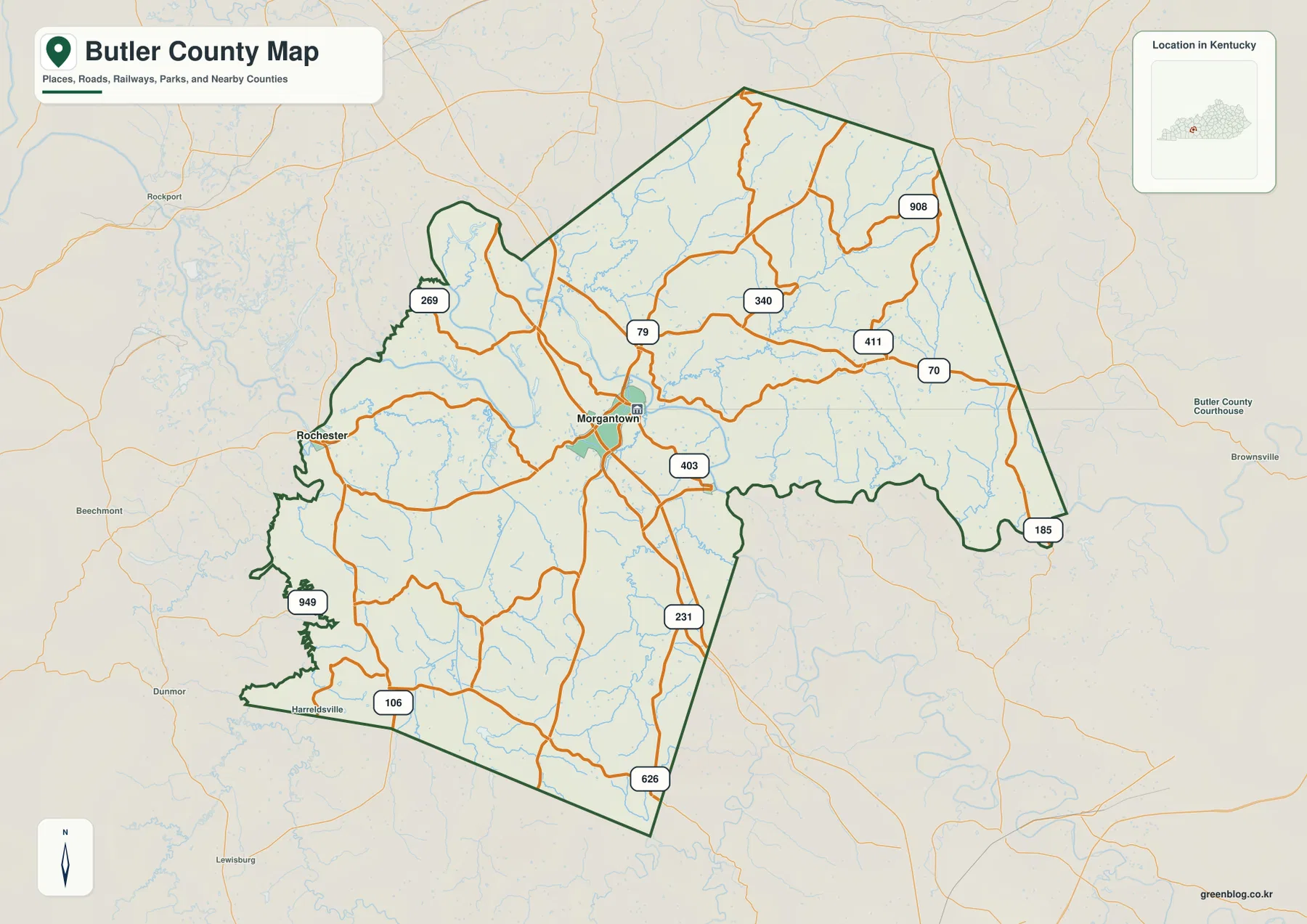
On the county reference map, Morgantown stands out because several important roads pass through or near the city. KY 79, KY 70, and US 231 make it possible to trace the county in several directions without first learning every smaller route. From Morgantown, the road pattern spreads toward the Green River corridor, the eastern county line, and the southern part of Butler County. The routes are not arranged in a rigid grid; they bend and branch around the same valleys and hills that appear more clearly on the water and elevation maps.
Rochester appears to the west near the Green River, giving the map a useful second landmark. Roads such as KY 269, KY 403, KY 411, KY 185, and other state routes fill in the interior and outer portions of the county. The boundary labels also help with regional orientation: Ohio County lies to the north, Grayson County to the northeast, Edmonson County to the east, Warren County to the southeast, Logan County to the south, and Muhlenberg County to the west.
The city-connections map removes most of that detail and focuses on Morgantown, Rochester, and Woodbury. Rochester is labeled at roughly 10 miles from Morgantown, while Woodbury is about 4 miles away. Those measurements are straight-line distances between mapped points rather than driving distances, so they should not be used to estimate a road trip. Their value is simpler: they show that Rochester is the more distant western point and Woodbury is a nearby eastern reference.
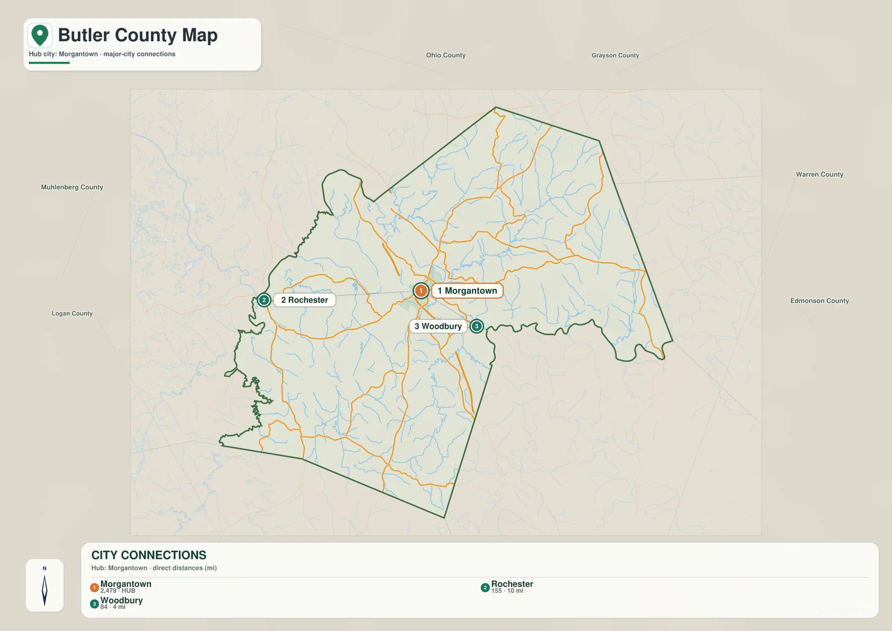
Using both maps together keeps the geography clear without overloading the page. The city map answers the basic question of where the three communities sit relative to one another. The reference map then adds the roads, county lines, and surrounding context. A reader can find Rochester on the simple map, switch to the county map, and immediately see its relationship to the Green River and the western road network. Woodbury works the same way on the eastern side of Morgantown.
Green River ties together the central and western landscape
The Green River is the dominant named waterway on the Butler County water map. It bends through the county and passes close enough to Morgantown and Rochester to serve as a practical geographic guide. Several small named lakes also appear near the river corridor, including Doolin Lake, Middle Lake, and Dotson Lake, with Martin Lake farther east. These are useful local reference points rather than large reservoirs that define the county as a whole.
The tributaries show how much more detailed the drainage picture becomes away from the main river. Indian Camp Creek and East Prong Indian Camp Creek appear in the northern and northeastern portion of the county, while Welchs Creek is another prominent name in that area. Little Reedy Creek and Big Reedy Creek extend through the eastern side. Renfrow Creek, Muddy Creek, and Little Muddy Creek are labeled farther south and southwest, and the Barren River appears near the southeastern edge.
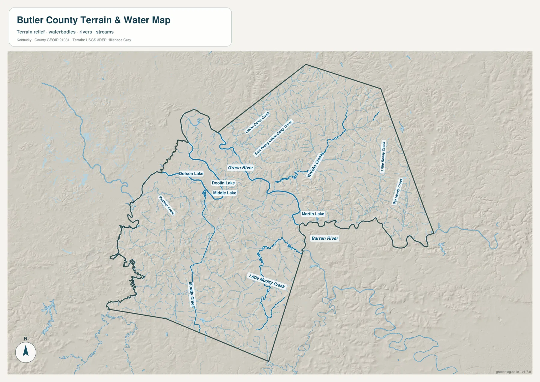
The map is especially useful when the communities are kept in mind. Morgantown sits near the central Green River corridor, Rochester is farther west along the same broad river landscape, and Woodbury is closer to Morgantown on the eastern side. This makes the water layer more than a list of stream names: it helps explain why the county’s roads and communities are distributed around valleys instead of forming a simple checkerboard pattern.
This water map is intended for geographic reference, not for flood or navigation decisions. It does not show current river stage, flood-frequency zones, water quality, safe boating depth, or property ownership. Kentucky Tourism’s material on Morgantown and the Green River provides useful local recreation context, but current weather, access, and river conditions should always be checked separately before a trip.
Elevation ranges from about 117 to 246 meters across valleys and ridges
The elevation map shows a mapped range of roughly 117 to 246 meters, with an average near 156 meters. The lowest colors follow broad parts of the Green River corridor and several tributary valleys. Higher colors appear repeatedly between those waterways, especially toward the northeastern and eastern interior and in parts of the south. Butler County therefore looks less like a surface that steadily rises in one direction and more like a sequence of lower valleys separated by rolling ridges.
That pattern is easy to miss on a road-only map. A route can look fairly direct at county scale even though the surrounding ground rises and falls between creeks. On the elevation layer, those changes become visible as alternating bands and patches of green, yellow, and brown. The northeastern section has many short valleys and higher divides, while central and western areas contain broader low corridors associated with the Green River and its tributaries.
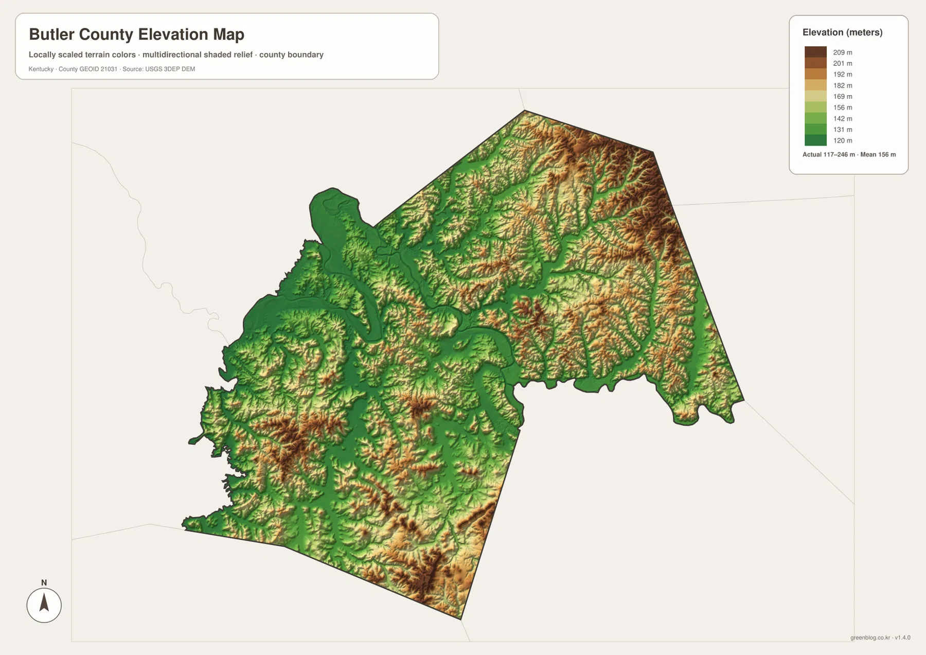
The water and elevation maps are most informative when viewed as a pair. Find the Green River, Welchs Creek, Big Reedy Creek, or Muddy Creek on the water layer, then compare the same area on the elevation map. Many of the lower colors follow those valleys, while higher ground occupies the land between them. This relationship also helps explain why smaller roads frequently curve rather than crossing the county in long straight lines.
The elevation values are suitable for countywide comparison, not site design. A building lot, bridge approach, drainage system, road grade, excavation plan, or legal survey requires more detailed authoritative elevation information and, when appropriate, field measurements. The county map is best treated as a clear overview of relative relief rather than a substitute for engineering data.
Which Butler County map is most useful for your task?
For general orientation, start with the county reference map and locate Morgantown first. From there, follow the Green River toward Rochester and use the road labels to understand how the county connects north, east, south, and west. This is the best choice when neighboring counties or state routes matter. The city-connections map is cleaner when the goal is simply to compare Morgantown, Rochester, and Woodbury without the distraction of many minor roads.
For natural geography, begin with the water map and use the Green River as the main guide. Named creeks such as Indian Camp Creek, Welchs Creek, Big Reedy Creek, and Muddy Creek make it easier to divide the county into smaller areas. Then move to the elevation map and compare the same places to see which valleys are lower and where the ridges rise between them. This sequence is useful for classroom explanations because it links place names to visible landforms instead of presenting them as separate lists.
For printing, choose the map that best matches the question. The county map emphasizes roads and boundaries, the city map simplifies community positions and straight-line distances, the water map highlights rivers and named tributaries, and the elevation map shows relative relief. All four use the same county extent, so a location found on one map can be compared with the others without changing geographic context.
Frequently Asked Questions
How far are Rochester and Woodbury from Morgantown on the city map?
The city map labels Rochester at about 10 miles from Morgantown and Woodbury at about 4 miles. These are straight-line distances between mapped points, not driving distances. Use a current routing service when road mileage or travel time is important.
Which waterways are labeled besides the Green River?
The water map labels the Barren River, Indian Camp Creek, East Prong Indian Camp Creek, Welchs Creek, Little Reedy Creek, Big Reedy Creek, Renfrow Creek, Muddy Creek, and Little Muddy Creek. Dotson Lake, Doolin Lake, Middle Lake, and Martin Lake are also shown.
Can the 117–246 meter elevation range be used for construction or surveying?
No. The elevation map is designed to compare lower valleys and higher ridges across the county. Construction design, road grading, drainage engineering, and legal surveying require higher-resolution official data and, when necessary, field measurements.
Map File Information
The original Butler County map files are bundled as high-resolution JPG images for printing and offline use. Each file is 3638 × 2572 pixels, providing more detail than the web preview for roads, waterways, and terrain.
- Included Files: county map, city map, water map, elevation map
Related Maps
Sources and references
Local Green River context is available from Kentucky Tourism’s Morgantown Trail Town feature. Boundary data are available through the U.S. Census Bureau TIGER/Line program, water data through USGS National Hydrography, and elevation data through the USGS 3D Elevation Program.
Green Map creates custom-edited map images using open geographic data sources such as geoBoundaries, Natural Earth, OpenStreetMap, and government open data. These maps are edited visual materials, not raw data files, and are provided for education, documents, presentations, and graphic reference.