Carter County stretches across northeastern Kentucky with two clear town anchors: Grayson in the eastern half and Olive Hill to the west. Grayson is the county seat and the more concentrated highway reference, while Olive Hill provides a useful western point for following US 60 and roads toward the county’s hillier western side. Interstate 64 crosses the county from the Rowan County line to the Boyd County line, so the relationship among I-64, US 60, Grayson, and Olive Hill is the simplest way to build an initial sense of direction. High-resolution map files are available for download in the section below.
This page provides four Carter County map views for screen use, and the original high-resolution JPG files can be downloaded together in a ZIP archive for printing and closer inspection. The maps separate the road network, the two principal cities, the river-and-lake system, and elevation. Named water features include the Little Sandy River, Tygarts Creek, Grayson Lake, Rose Lake, and Olive Hill Reservoir, while the elevation map shows an actual county range of about 167 to 397 meters. The files are intended for general geographic reference, not parcel boundaries, flood determinations, engineering, surveying, or live navigation.
Table of Contents
Grayson and Olive Hill make the highway pattern easier to understand
Grayson is the strongest orientation point on the general map. It sits in the eastern half of Carter County, where several important routes come together. The Kentucky Transportation Cabinet’s 2026 state primary road listing identifies I-64 as an east-west interstate across the entire county, US 60 as the route running through Olive Hill and Grayson, KY 7 as a north-south connection into Grayson, KY 9 as the AA Highway northwest of the city, and KY 1 as a short primary connection north of Grayson. Those routes explain why the road pattern becomes denser around the county seat.
Olive Hill lies well to the west and is surrounded by a different group of local routes. The map labels KY 2, KY 59, KY 174, KY 182, KY 396, KY 474, KY 955, and KY 986 in the western and central parts of the county. East of Grayson, US 60 continues toward the county boundary, with KY 207 and KY 773 providing additional references near the eastern side. Rather than forming a regular grid, many of these roads bend through narrow valleys and around ridges, which is why the water and elevation maps add useful context to the route map.
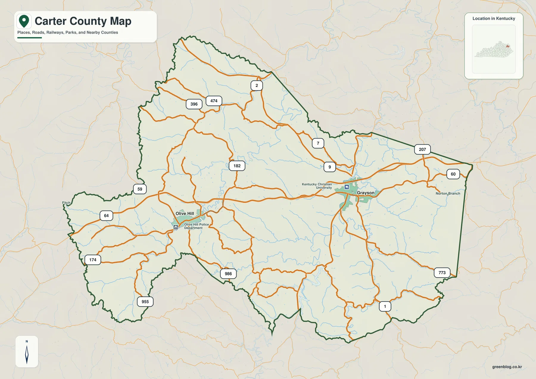
The map also includes several useful local labels beyond the two cities. Kentucky Christian University appears at Grayson and helps identify the urban area, Norton Branch is marked to the east, and Fitch appears near the western edge. These smaller labels are helpful because Carter County is long enough that the space between Grayson and Olive Hill contains many road junctions and creek valleys rather than one continuous developed corridor. Following the major roads first, then adding the minor place labels, is an effective way to keep the map readable.
The City of Grayson’s official site describes Grayson as the Carter County seat and notes the convergence of I-64, US 60, and the John Y. Brown Jr. AA Highway. That local description matches the visual concentration of routes on the map. Olive Hill plays a different role: it is the most useful western town reference and the community associated with access to Carter Caves State Resort Park. Seeing the two towns as separate anchors is more informative than treating the county as if all roads radiated from a single center.
The two-city map reveals an east-west settlement pattern
The city map intentionally simplifies Carter County to two ranked cities, Grayson and Olive Hill. Grayson sits east of center, while Olive Hill occupies the western half. That separation is the key point. A large area of wooded ridges, creek valleys, and smaller communities lies between and around them, so the county does not read as one compact urban cluster. The simplified city layer is especially useful when a presentation or handout needs the basic settlement pattern without the visual weight of route numbers and terrain detail.
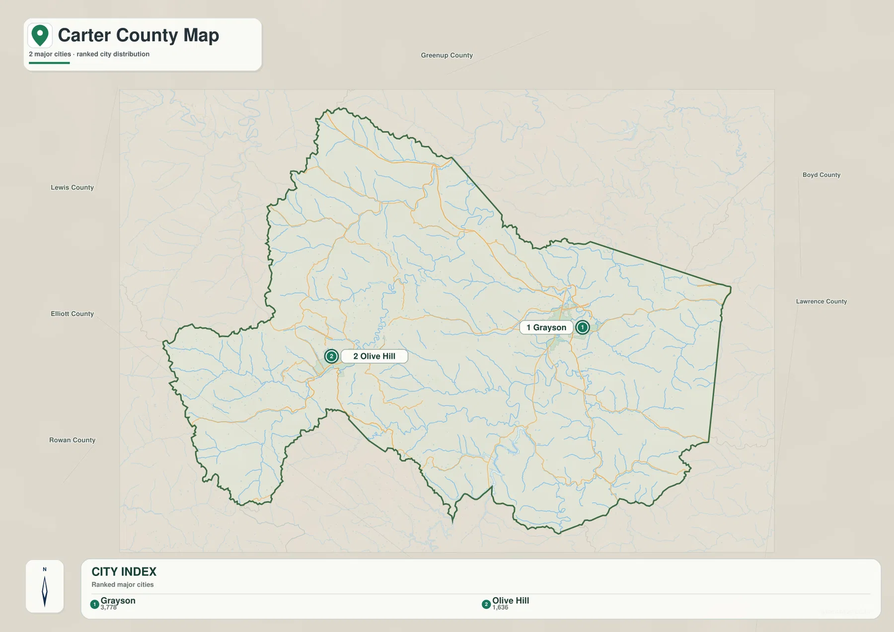
When the city layer is paired with the general map, the transportation differences become clearer. Grayson is close to the junctions of KY 1, KY 7, and KY 9 and sits near both I-64 and US 60. Olive Hill is also tied to the interstate and US 60 corridor, but its surrounding road pattern spreads into the western hills through several smaller state routes. The two places therefore work well as bookends for a county-wide explanation: Grayson helps orient the east and southeast, while Olive Hill is the better starting point for the west and northwest.
Olive Hill also provides useful local context for Carter Caves State Resort Park. Kentucky State Parks lists the park at an Olive Hill address and describes wooded hills containing numerous caves, natural bridges, sinkholes, and other features. The park itself is not plotted as a labeled point on these county maps, so this page should not be used as a park trail or entrance map. Still, the official park information helps explain why Olive Hill is a meaningful western reference when discussing the county’s rugged terrain and recreational geography.
Little Sandy River, Tygarts Creek, and three mapped lakes organize the valleys
The water map shifts attention away from highways and toward Carter County’s valleys. In the east-central part of the county, the Little Sandy River forms the most prominent named river corridor. The Little Fork Little Sandy River approaches from the south, while Barrett Creek, Everman Creek, Little Fork, and Straight Creek occupy adjoining valleys. Grayson Lake lies south of Grayson and stands out as the largest mapped water body in that part of the county, giving the southern road-and-valley pattern a clear geographic reference.
Farther west, Tygarts Creek is the dominant named stream through the central and western hills. Smoky Creek enters from the west, and Big Sinking Creek crosses the south-central area toward the Little Sandy system. Rose Lake is visible near the Tygarts Creek corridor, while Olive Hill Reservoir sits farther west. Grassy Creek is labeled in the northern section. Together, these features show that Carter County is divided by many narrow drainage valleys rather than by one broad river plain.
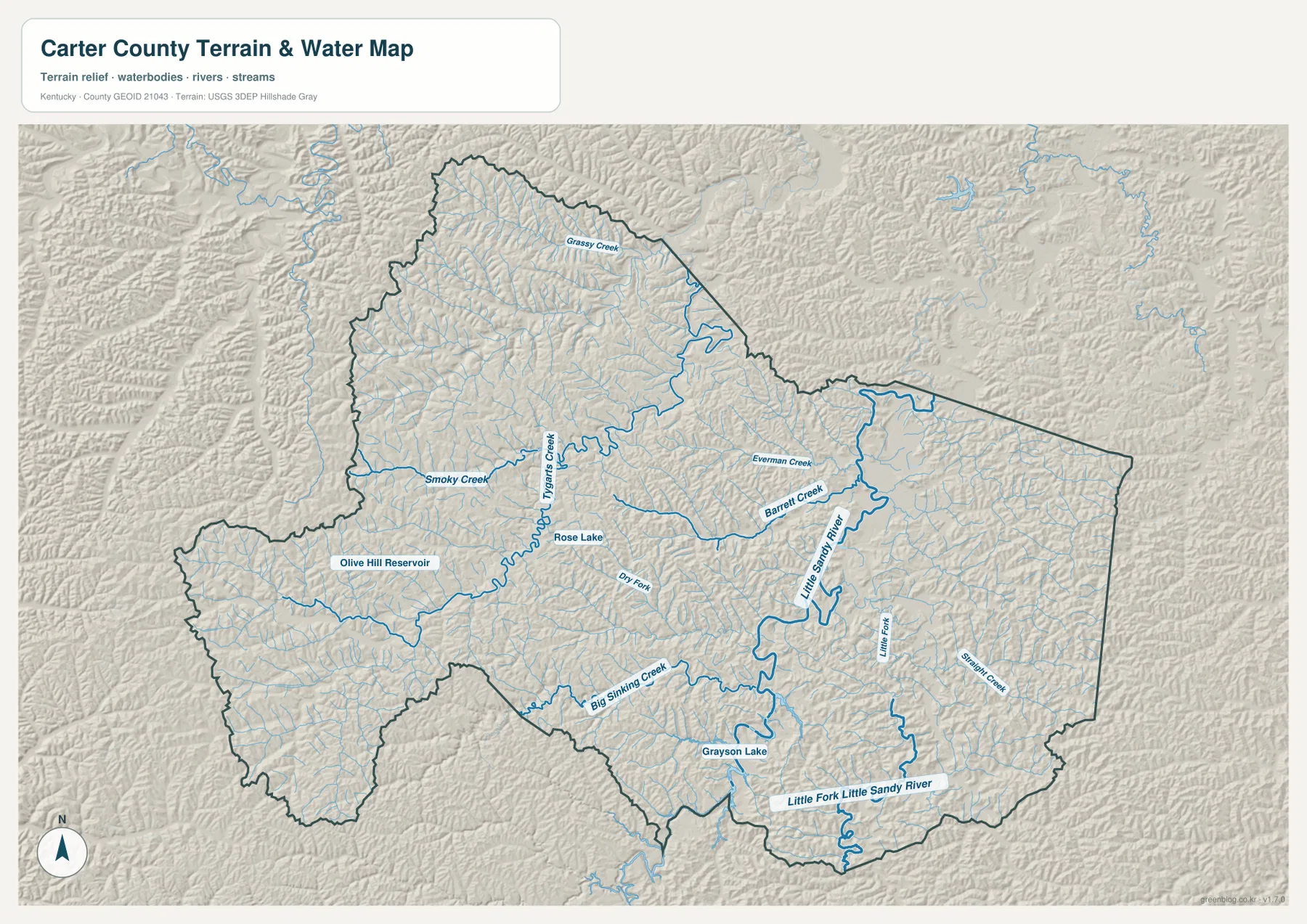
The shaded terrain beneath the waterways makes the relationship between streams and relief easy to see. The Little Sandy River follows a broader low corridor than many of the smaller creeks, while Tygarts Creek and Big Sinking Creek wind through narrower valleys. Grayson Lake occupies a low basin where several valley lines converge. The Kentucky Department of Fish and Wildlife Resources identifies the Grayson Lake Wildlife Management Area in Carter and Elliott counties, reinforcing the importance of the lake as a southern Carter County landmark rather than just a small local pond.
This map is not a current flood, water-level, water-quality, boating-access, or property-boundary product. Reservoir operations and stream conditions can change, and the presence of a mapped blue line does not establish public access or safe crossing conditions. For recreation or property decisions, consult current park, water, and flood information. The purpose here is to compare named rivers, creeks, lakes, and reservoirs and see how their valleys fit into the county as a whole.
A 167–397 m elevation range separates western ridges from eastern low corridors
The elevation map shows an actual Carter County range of roughly 167 to 397 meters, with a mean near 265 meters. The western and northwestern sections contain the broadest concentrations of brown and tan ridges, and the terrain around Olive Hill alternates quickly between narrow valleys and higher slopes. By contrast, the Grayson area and the Little Sandy River corridor in the eastern half contain more green lowlands. The difference is strong enough that the county reads as two related but visually distinct terrain zones.
Several low corridors extend into the northern hills, and Tygarts Creek creates another green route through the central part of the county. Around Grayson Lake in the south, the water and valley floor are low, but steep short ridges rise close to the shoreline and tributaries. The southwest projection of the county also contains high, closely spaced ridge tops. Comparing these areas with the water map shows a consistent pattern: streams occupy the lower gaps while narrow ridges fill the spaces between them.
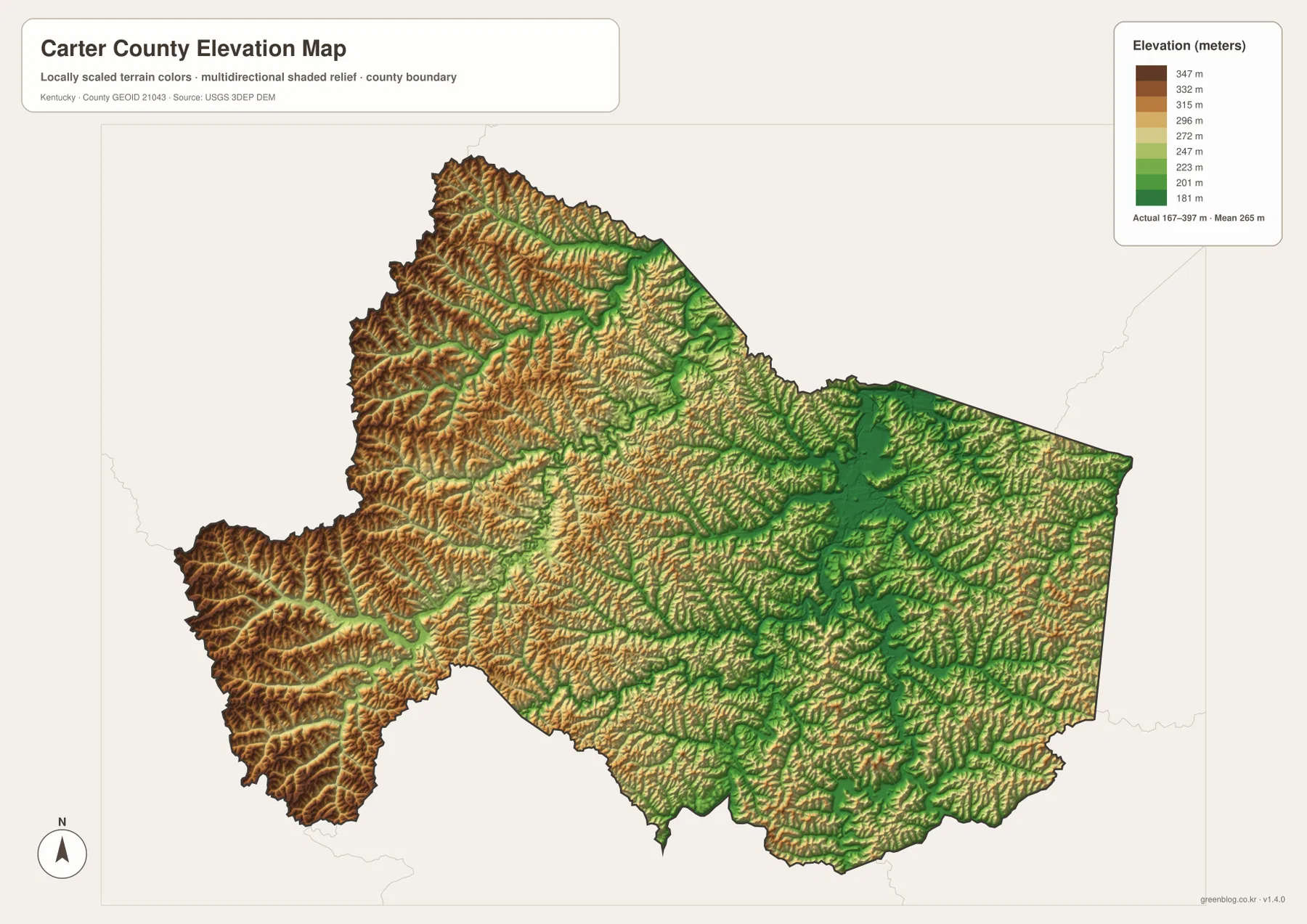
Carter County is better described as a landscape of repeated ridges and valleys than as a county dominated by one high mountain or one flat plain. That relief helps explain the curved road network. US 60 connects Olive Hill and Grayson, but many smaller routes must follow valleys, cross ridges, or turn around steep ground. On the general map those bends can look irregular; on the elevation map they make more sense because the terrain leaves a limited number of low passages through the hills.
The colors are generalized for county-scale comparison. They are useful for seeing where the land is relatively low or high, but they are not survey measurements for a particular lot, road grade, building site, or drainage project. Detailed engineering or property work requires source elevation data such as the USGS 3D Elevation Program and, where appropriate, professional surveying. For this page, the main takeaway is the county-wide contrast between higher western ridges and lower river-and-lake corridors in the east and south.
Choose the map by question: highways, towns, water, or relief
The general map is the best single choice for county orientation because it combines Grayson, Olive Hill, the boundary, I-64, US 60, and the state highway network. The city map is cleaner when the only question is where the two principal cities sit relative to one another. Used together, they provide a simple sequence: learn the east-west town pattern first, then add road numbers and smaller place references only when they are needed.
The water map is more useful when the subject is Grayson Lake, the Little Sandy River, Tygarts Creek, or the many tributary valleys. The elevation map answers a different question by separating the 167–397 m relief into lower corridors and higher ridges. It is especially effective for explaining why the western side around Olive Hill looks more dissected and why the Grayson and Little Sandy River area contains broader low zones. Pairing those two physical-geography maps gives a fuller picture than either one alone.
For a classroom handout or presentation, choose the layer that matches the point you are making instead of crowding every label into one graphic. A transportation page may use the general and city maps, while a lesson about Grayson Lake or creek valleys may use the water and elevation maps. For trip planning, these county-scale maps are a useful first reference, but current turn-by-turn directions, park entrances, trail conditions, water access, and safety information should come from the appropriate official sources.
Frequently Asked Questions
Which map is simplest for comparing Grayson and Olive Hill?
The city map is the cleanest choice because it strips away most road and terrain detail and places Grayson in the eastern half and Olive Hill in the western half. If you also need to understand how they connect, switch to the general map to add I-64, US 60, and the state routes around each town.
Which file best shows Grayson Lake and the Little Sandy River system?
Use the water map. It shows Grayson Lake together with the Little Sandy River, Little Fork Little Sandy River, Barrett Creek, Big Sinking Creek, Tygarts Creek, and other named tributaries. The elevation map is useful as a companion when you want to see how those waterways occupy lower valleys between surrounding ridges.
What is the main contrast on the 167–397 m elevation map?
The most visible contrast is between the higher, more tightly ridged west and northwest and the lower corridors around Grayson, the Little Sandy River, and Grayson Lake. The mean is about 265 meters, but the colors are intended for relative county-wide comparison and should not be treated as precise site elevations.
Map File Information
Carter County map files
- Included Files: county map, city map, water map, elevation map
- File Type: JPG
Related Maps
Sources and references
County government information is available from the official Carter County website, and the City of Grayson provides local context for the county seat and its major highway connections. Route classifications for I-64, US 60, KY 1, KY 7, and KY 9 can be checked in the Kentucky Transportation Cabinet Carter County State Primary Road System. Western county context is available from Kentucky State Parks’ Carter Caves State Resort Park page. Boundary data can be referenced through U.S. Census Bureau TIGER/Line, hydrography through USGS National Hydrography, and elevation through the USGS 3D Elevation Program.
Green Map creates custom-edited map images using open geographic data sources such as geoBoundaries, Natural Earth, OpenStreetMap, and government open data. These maps are edited visual materials, not raw data files, and are provided for education, documents, presentations, and graphic reference.