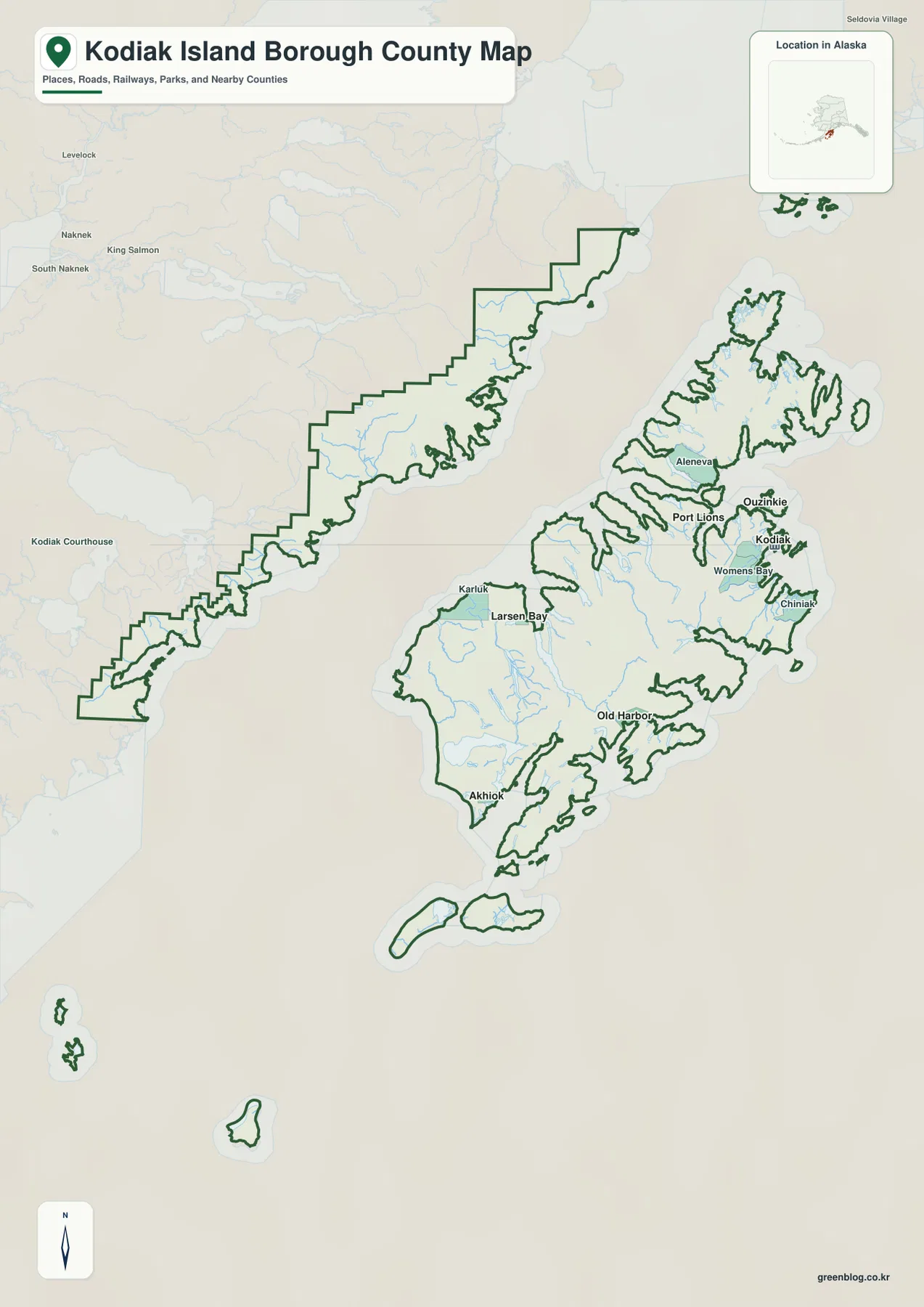
Kodiak Island Borough is easier to understand as a network of islands, coastal settlements, bays, and a separate western mainland section than as a single compact land area. On the supplied general map, Kodiak is the clearest northeastern reference point on the main island. Ouzinkie and Port Lions sit farther north and northwest, while Old Harbor and Akhiok are much farther south. Larsen Bay and Karluk appear on the western side of the main island. The article below follows only features shown in the supplied maps and county package, and the matching high-resolution JPG files can be downloaded together from the map file box near the end of the page.
The borough outline is unusually broken up compared with a simple inland county map. In addition to Kodiak Island, the mapped boundary includes smaller islands to the north and south and a long coastal mainland section to the west. The terrain-and-water map adds Uyak Bay, Karluk River, Thumb River, Falls Creek, Olga Bay, Kamishak Bay, Soluka Creek, and the Pacific Ocean, along with shaded mountain relief. A useful way to read the page is to locate the settlements first, then use the water map to understand how bays, rivers, and rugged coastal terrain separate those places.
Table of Contents
Kodiak anchors the northeast while other communities spread around the island
The densest concentration of place labels on the general map is around Kodiak. Womens Bay appears immediately to the west of the city, Chiniak lies farther along the eastern side, and Ouzinkie and Port Lions are positioned to the north and northwest. Aleneva is also labeled on an island farther north. This cluster gives readers an easy starting point because several settlements can be compared within a relatively small part of the full borough map.
The pattern changes quickly as the eye moves south and west. Old Harbor is shown on the southeastern coast of the main island, Akhiok is near the far southwestern end, and Larsen Bay and Karluk occupy separate locations along the west side. Large areas of water and mountain terrain lie between many of these labels. The map therefore does not look like a continuous urban corridor. Instead, settlements appear as distinct coastal reference points around a very irregular island outline.
The borough boundary includes the main island, smaller islands, and a western mainland strip
The general map makes an important point that the borough name alone does not fully communicate: the mapped area is not limited to Kodiak Island. Several separate islands are enclosed by the boundary, and the western side of the borough extends along a long piece of mainland coast across a broad body of water from the main island. Nearby administrative labels include Kenai Peninsula Borough, Dillingham Census Area, and Bristol Bay Borough, which help place Kodiak Island Borough within the larger Alaska map.
The shoreline is deeply indented rather than smooth. Small bays, points, and narrow coastal sections repeat around the main island and western mainland. That makes the map useful for regional orientation but unsuitable for estimating exact travel distance simply by looking at how close two points appear on the page. For legal boundary work or survey-level use, the proper choice is an official boundary dataset rather than this reference map.
The city index highlights six settlement reference points
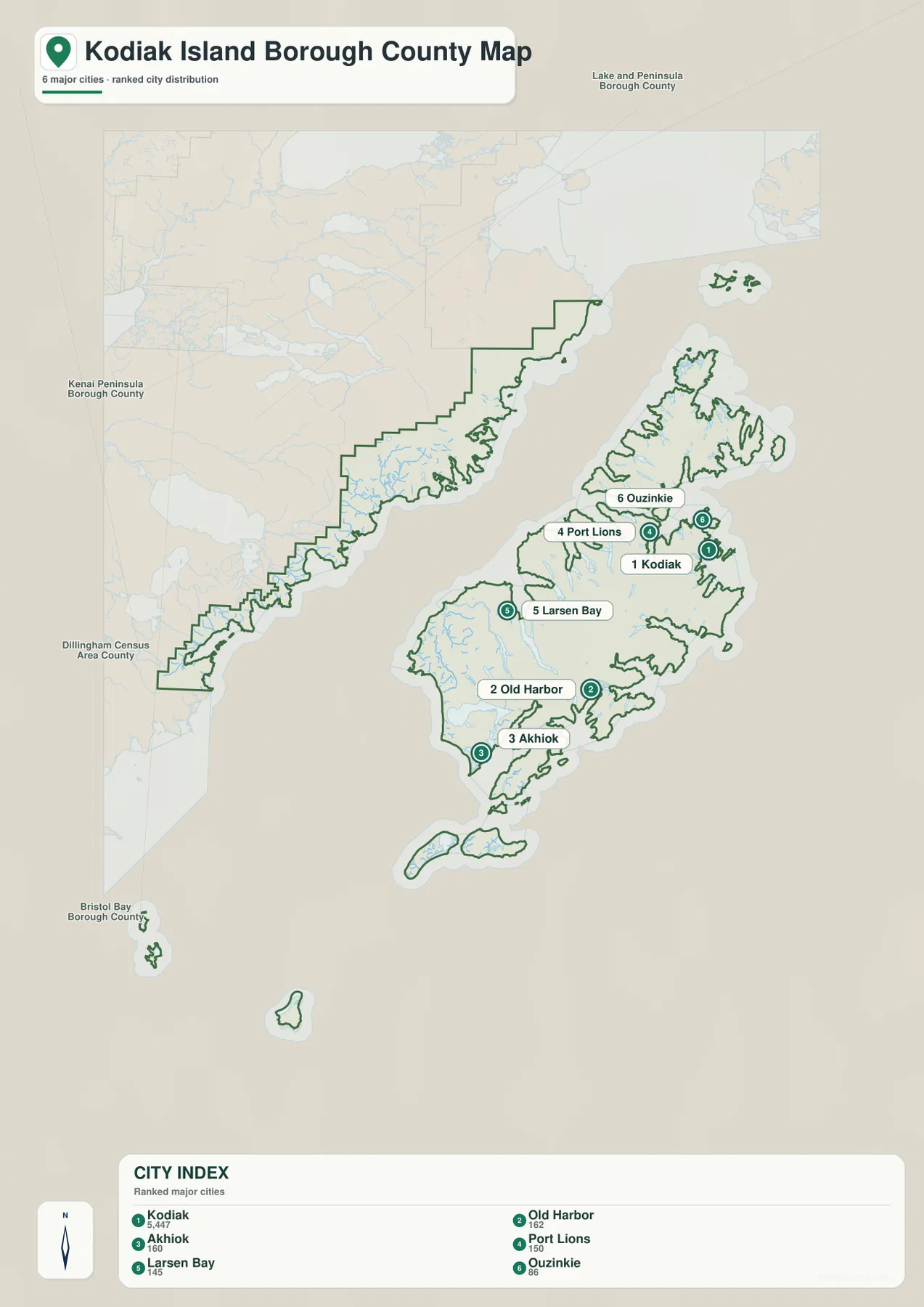
The city-index map simplifies the settlement picture by ranking six places: Kodiak, Old Harbor, Akhiok, Port Lions, Larsen Bay, and Ouzinkie. Kodiak is marked first, while the other five are distributed around the northern, western, and southern parts of the main island area. The map is especially helpful for readers who want to compare the relative positions of the principal labeled communities without the additional smaller place names that appear on the general map.
The index also displays a number beside each city name. Those values are part of the supplied map, but the package does not provide a separate date or statistical note that would justify treating them as a current population table in this article. For that reason, the safer use is to treat the map as a ranked city-location reference. Anyone who needs current population figures should check the latest Census data separately.
The difference between the city index and the general map is useful in practice. Womens Bay, Chiniak, Karluk, and Aleneva appear on the general map but are not among the six ranked city labels on the index. The omission does not mean those places are absent from the borough. It simply reflects the narrower purpose of the city-index sheet. Using both maps together gives a fuller picture without forcing every label into one crowded view.
Uyak Bay and Karluk River define the western side of the main island
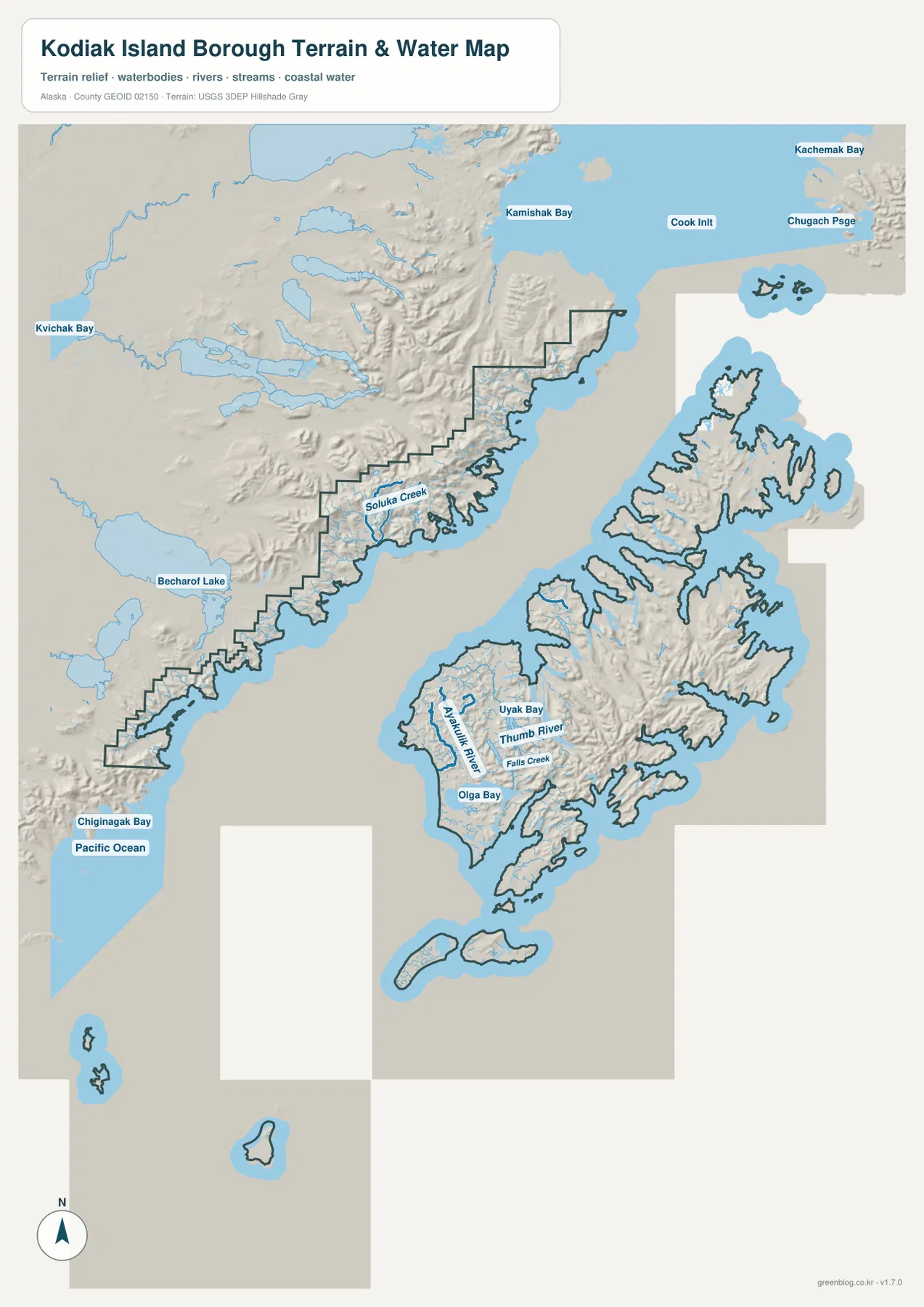
On the terrain-and-water map, Uyak Bay stands out on the western side of the main island. Karluk River, Thumb River, and Falls Creek are labeled nearby, and Olga Bay appears farther south. Together these names show that the western coast is not a single unbroken shoreline. Rivers and narrow coastal inlets divide the terrain into separate local areas, while the shaded relief shows rugged ground between the waterways.
Karluk River is a useful cross-reference between the maps. A reader can first locate Karluk on the general map, then move to the terrain-and-water map to see the nearby river and western coastal setting. Larsen Bay can be compared in the same way. The two settlements both lie on the west side of the island, but they occupy different coastal positions rather than one continuous built-up strip.
The western mainland section sits between large coastal waters
The left side of the terrain-and-water map shows the borough’s western mainland section. Kamishak Bay and Cook Inlet are labeled to the north outside the borough boundary, while Chignik Bay and the Pacific Ocean appear toward the southwest. Kvichak Bay and Becharof Lake are also labeled outside the borough and help orient the reader to the broader region. Within the western section itself, Soluka Creek is one of the named water features shown on the map.
This sheet should be read as a terrain-and-water reference, not as a nautical chart or flood map. It does not provide water depth, tides, navigation routes, current streamflow, or flood probability. The map is useful for understanding where major labeled waters and coastal terrain lie relative to the borough boundary. More detailed hydrographic work should rely on official USGS or other purpose-built datasets.
Old Harbor and Akhiok sit within a rugged southern coastline
The southern half of the main island has a very different visual character from the Kodiak area. Old Harbor is positioned on the southeastern coast, while Akhiok lies much farther southwest. The shoreline between and around them is cut by numerous bays and points, and the terrain shading reaches close to the coast. Even when two labels appear reasonably close on the page, the map does not imply an easy or direct overland route between them.
The same contrast helps explain why settlement labels are more concentrated around Kodiak and more widely separated in the south and west. The supplied maps do not provide a transportation analysis, but they clearly show large areas of mountainous terrain and water between the communities. Shaded relief is useful for comparing broad terrain form, yet it should not be used to read an exact peak elevation or slope. Detailed elevation questions belong with an official elevation dataset such as the USGS 3D Elevation Program.
Using all three maps reveals how settlements relate to islands, bays, and mountain terrain
The general map is the best starting point for the borough outline and the broad distribution of place names. From Kodiak, a reader can move north toward Ouzinkie and Port Lions, south toward Old Harbor and Akhiok, and west toward Larsen Bay and Karluk. The city index then reduces the page to six principal settlement markers, which makes their relative positions easier to compare. Finally, the terrain-and-water map explains the physical setting around those labels with bays, rivers, coastal water, and shaded mountain relief.
For example, someone comparing Kodiak and Old Harbor can first find both on the general map, then use the city index to see the large north-south separation. The terrain-and-water sheet adds the rugged southern coastline and mountain relief between the two areas. A reader interested in Karluk or Larsen Bay can instead begin on the west side of the general map and then look for Uyak Bay and Karluk River on the water sheet. This step-by-step approach is much easier than trying to interpret every feature from a single crowded map.
- For the borough outline and the widest set of place labels: start with the general map.
- For a quick comparison of six principal city locations: use the city-index map.
- For bays, rivers, coastal water, and broad terrain relief: use the terrain-and-water map.
- For legal boundaries, detailed hydrography, or exact elevation: consult the relevant official dataset.
Which map is best for printing, teaching, or regional reference?
The general map works well when a handout or presentation needs the full borough outline and multiple community names. The city-index map is cleaner when the goal is only to compare Kodiak, Old Harbor, Akhiok, Port Lions, Larsen Bay, and Ouzinkie. The terrain-and-water map is the better choice for explaining Uyak Bay, Karluk River, the western mainland section, and the rugged coastal landscape. Selecting the map that matches the question keeps the visual material focused.
The downloadable ZIP below contains the three larger JPG originals corresponding to the WebP maps used in the article. They are suitable for personal geographic reference, classroom handouts, presentations, and printed regional materials. High resolution does not turn them into survey plats, legal boundary documents, flood studies, nautical charts, or engineering terrain products. Any decision that depends on exact boundaries, water conditions, or elevation should be checked against the appropriate official source.
Frequently Asked Questions
Where are Kodiak and Old Harbor on the map?
Kodiak is shown on the northeastern side of the main island, while Old Harbor is much farther south on the eastern coast. The general map and city index make that separation easy to see. The terrain-and-water map also shows the rugged coastal and mountain setting between the two parts of the island.
Which map is best for Uyak Bay and Karluk River?
The terrain-and-water map is the best choice. Uyak Bay is prominently labeled on the west side of the main island, with Karluk River, Thumb River, Falls Creek, and Olga Bay also shown nearby. It helps to locate Karluk and Larsen Bay on the general map first and then switch to the water sheet for the surrounding coastal features.
What is included in the downloadable ZIP?
The archive contains three high-resolution JPG files matching the subjects used in the article: the general borough map, the city-index map, and the terrain-and-water map. They are intended for geographic reference, printing, classroom use, and presentations rather than legal surveying, navigation, flood determination, or engineering design.
Map File Information
The Kodiak Island Borough maps shown in this article are available as high-resolution JPG files. The ZIP contains the larger originals for the general map, city-index map, and terrain-and-water map.
- Included Files: 3 high-resolution JPG images
- File Type: JPG files in one ZIP archive
Related Maps
Sources and further reference
For official administrative boundary files, see the U.S. Census Bureau TIGER/Line Shapefiles. Detailed river and water information is available through USGS National Hydrography, and more precise elevation data can be found through the USGS 3D Elevation Program. The geographic descriptions in this article are based on the supplied Kodiak Island Borough maps and asset manifest.
Green Map creates custom-edited map images using open geographic data sources such as geoBoundaries, Natural Earth, OpenStreetMap, and government open data. These maps are edited visual materials, not raw data files, and are provided for education, documents, presentations, and graphic reference.