Renville County sits in south-central Minnesota, where a broad agricultural interior meets the deeply cut Minnesota River valley along the county’s southern edge. Olivia is the county seat, and the county government lists 10 incorporated cities and 27 townships. The maps on this page separate the county into four useful views: a boundary-and-road map, a ranked city map, a terrain-and-water map, and an elevation map. High-resolution JPG copies of all four are available in the file box later on the page, so you can inspect the web versions first and then download the originals for printing or reference.
Two geographic lines organize much of the county. Across the middle, Renville, Danube, Olivia, Bird Island, Hector, and Buffalo Lake form an east-west chain associated with U.S. Highway 212. Farther south, the Minnesota River bends across the county edge while Morton, Franklin, and Fairfax occupy a second band of settlement closer to the valley. Waterways run from the higher interior toward that river, and the elevation map makes the drop especially visible. Looking at the maps together explains why the county’s cities, roads, creeks, and relief do not form a simple rectangular pattern even though much of the interior is open rural land.
Table of Contents
An east-west line of towns centered on Olivia
The county map gives the clearest overall orientation. Renville County has a mostly straight northern edge, but the southern boundary becomes irregular where it follows the winding Minnesota River. The eastern side also steps inward before continuing south, producing a shape that is easy to recognize on the map. Nearby county labels help place it within the region: Kandiyohi lies to the north, Redwood and Yellow Medicine are to the west and southwest, while Sibley, McLeod, and Nicollet lie to the east and southeast.
Olivia stands near the center of the main settlement corridor. Renville County’s planning profile describes Trunk Highway 212 and the Twin Cities & Western rail line as an east-west route serving Renville, Danube, Olivia, Bird Island, Hector, and Buffalo Lake. That same sequence is easy to follow on the supplied map. U.S. 71 runs south from the Olivia area toward Morton, providing a visible north-south connection between the central corridor and the Minnesota River side of the county. This crossroads position helps explain why Olivia functions as the county seat even though the county includes several other small cities.
The southern towns create a different pattern. Highway 19 runs across the lower part of the county near Morton, Franklin, and Fairfax rather than following the U.S. 212 chain. Morton sits close to both the river and the road leading south from Olivia. Franklin occupies the river-side band farther east, while Fairfax is near the southeastern part of the county where north-south and east-west roads meet. The result is a county with two readily visible settlement zones: a central line of towns and a lower group associated more closely with the river valley.
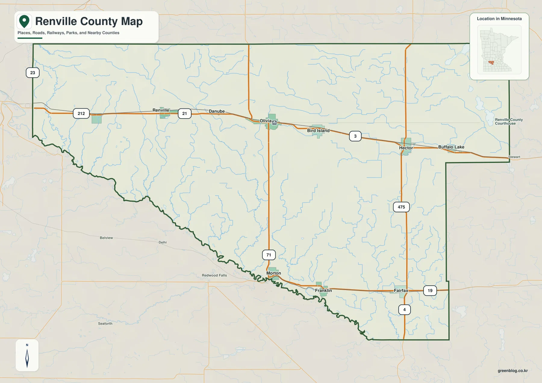
This version is the best starting point when the question is simply “where is everything?” It keeps cities and roads readable without hiding the dense creek network that crosses the interior. It also shows outside reference points such as Redwood Falls and Stewart, which are useful when placing the county relative to better-known nearby communities. The road symbols should not be treated as live navigation data, however. Current construction, closures, route restrictions, and turn-by-turn travel information should always be checked with an official transportation source.
What the six-city index reveals—and what it leaves out
The city map deliberately simplifies the county by ranking six larger communities rather than labeling every incorporated place. Its index lists Olivia at 2,205, Renville at 1,503, Hector at 1,130, Fairfax at 1,088, Bird Island at 930, and Buffalo Lake at 635. Those figures are part of the supplied map’s city index and are useful for understanding the map itself; they should not be assumed to be the latest population estimates. Anyone who needs current demographic figures should verify them separately with the U.S. Census Bureau.
The arrangement is more important than the numbers. Olivia occupies the central position, with Renville to the west and Bird Island and Hector to the east. Buffalo Lake sits near the eastern side of the county, while Fairfax is separated from the other five in the southeast. That pattern makes the U.S. 212 corridor particularly obvious: five of the six ranked cities form a loose east-west line, and Fairfax represents the southern settlement band. The visual contrast is helpful when explaining why local travel and services are not concentrated in one large urban center.
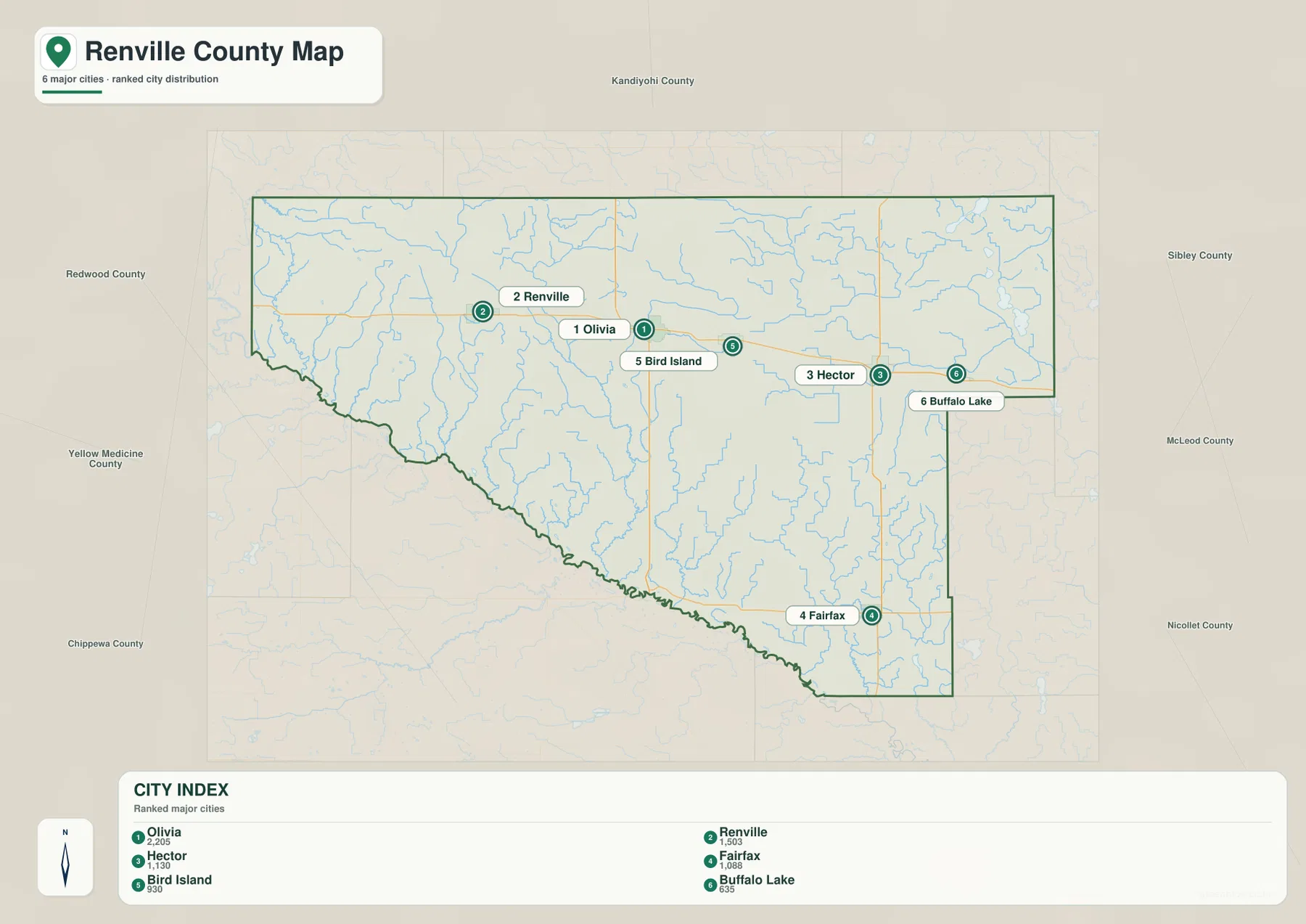
Renville County officially has 10 cities, so the six-city view is not a complete municipal inventory. Danube, Franklin, Morton, and Sacred Heart are also incorporated communities. Some of them appear on the general county map even though they are not included in this ranking. That distinction matters when the map is used in a report or classroom setting: the city index is a quick comparison of selected larger places, not evidence that the other communities are outside the county or unimportant.
The surrounding county labels add another layer of orientation. Kandiyohi County is directly north, Redwood County lies west of much of the map, and Yellow Medicine County is to the southwest. Sibley and McLeod appear on the east side, with Nicollet to the southeast. This makes the city map useful for regional context even when road detail is not needed. A reader can quickly see that Renville County stretches a long way east to west and that its principal communities are not clustered tightly around a single central point.
Minnesota River bends, Beaver Creek forks, and eastern lakes
The terrain-and-water map shifts attention away from roads and toward drainage. The Minnesota River is the dominant feature, tracing a long, irregular line along the southern side of the county. Because the county boundary follows many of the river’s bends, the waterway explains the jagged lower edge seen on the general map. Renville County’s parks department also emphasizes the river valley as a landscape of wooded bluffs, native prairie, bedrock exposures, and historic sites, so the river is both a boundary and one of the county’s strongest natural features.
Several named creeks organize the interior. West Fork Beaver Creek and East Fork Beaver Creek descend through the central part of the county and merge before reaching the river system. Hawk Creek appears in the west, Sacred Heart Creek runs through the southwestern interior, and Chetomba Creek is labeled in the northwest. Buffalo Creek crosses the eastern side. Smaller unnamed tributaries fill the spaces between them, showing that surface water reaches the Minnesota River through many branching channels rather than one single trunk stream.
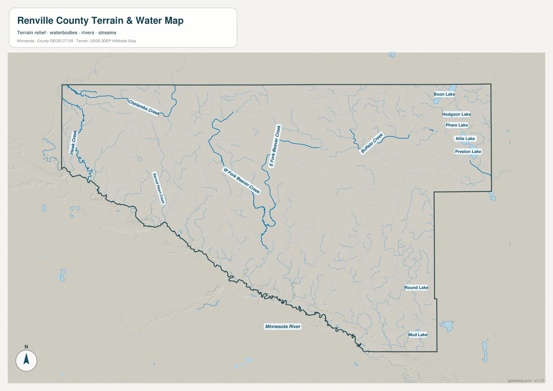
Lakes are more conspicuous in the eastern half. Boon Lake, Hodgson Lake, Phare Lake, Allie Lake, and Preston Lake appear near the northeast, while Round Lake and Mud Lake are farther south. The west and center show fewer large water bodies and a denser pattern of narrow streams. Comparing those areas is useful because it prevents the county from being described too simply as “river country.” The Minnesota River is the largest feature, but the eastern lakes and the many creek branches create very different local water settings inside the same county.
This map is intended as a geographic reference, not as a flood-risk, parcel, or navigation product. A creek shown here may pass through private land, and the visible river width or shoreline should not be used to make legal or safety decisions. For hydrologic data, the USGS National Hydrography program is a more appropriate authoritative reference. The map’s strength is comparative: it makes it easy to see which valleys connect to the Minnesota River and where the named lakes sit relative to the rest of the county.
A high interior surface dropping sharply to the river valley
The elevation map explains why the drainage pattern looks the way it does. Its legend reports an actual mapped range of about 246 to 348 meters, with a mean near 323 meters. Much of the northern interior appears in the higher brown and tan colors. The lowest green band hugs the Minnesota River, and additional low corridors extend inland along creek valleys. Instead of a perfectly level plain, the county looks like a broad high surface cut by drainage channels that become progressively lower toward the southern river.
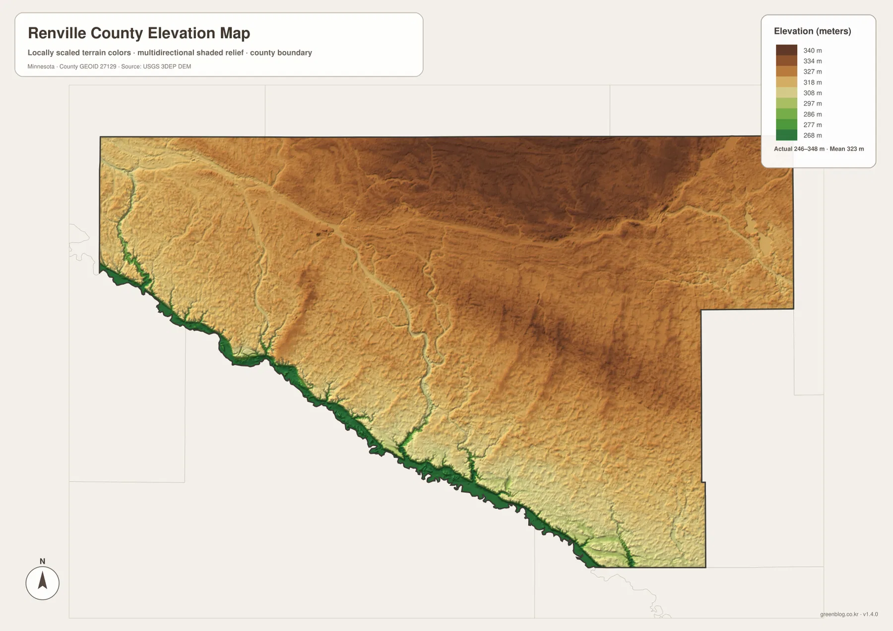
The relationship becomes clearer when this image is compared with the water map. The Beaver Creek forks occupy lower corridors running south through the interior, and the Hawk Creek and Sacred Heart Creek areas also follow visible depressions. Near the Minnesota River, the color changes are compressed into narrow bands, indicating steeper local relief than on the broad uplands. That visual evidence fits the county parks department’s description of steep wooded bluffs and exposed bedrock along the river valley.
Vicksburg County Park is a useful real-world example of that river-edge terrain. The county describes granite and gneiss outcrops, hiking trails, a large sandbar, and oxbow ponds at the park along the Minnesota River. Those features are much more varied than the smooth agricultural surface that dominates many interior areas. The elevation map cannot show individual rock exposures or trail conditions, but it provides the broad topographic setting that makes such river-valley features possible.
The elevation colors are generalized from digital elevation data and are not survey-grade measurements. They are appropriate for explaining countywide relief, comparing high and low areas, or adding terrain context to a presentation. They are not appropriate for engineering design, drainage construction, property-boundary work, or determining the exact elevation of a house or field entrance. For those needs, users should consult the USGS 3D Elevation Program or a qualified survey source.
Choosing the map that fits the question
Start with the general county map when you need a balanced overview. It is the only version here that combines city names, principal roads, the county outline, streams, and nearby places in one image. It works well for questions such as how Olivia relates to Renville and Hector, where Morton sits compared with the Minnesota River, or which direction to look for Redwood Falls. Because it retains more detail, it is also the best choice when a reader is unfamiliar with the county and needs several reference points at once.
Use the ranked city map when the main topic is settlement rather than transportation. It removes much of the road information and makes the positions of Olivia, Renville, Hector, Fairfax, Bird Island, and Buffalo Lake immediately visible. Choose the terrain-and-water map for river, creek, and lake questions, especially when explaining the Minnesota River boundary or the Beaver Creek system. The elevation map is the clearest option when the subject is relief, because it separates the higher northern interior from the lower southern valleys without requiring the reader to interpret contour lines.
For printed work, the downloadable originals are preferable to the smaller WebP previews embedded in the page. The archive contains the same four map subjects as high-resolution JPG files, each at 3638×2572 pixels. That resolution gives more room for resizing while keeping labels and boundaries legible. You can use one map by itself or pair the water and elevation versions when a project needs to connect stream locations with the shape of the land.
Frequently Asked Questions
Which side of Renville County follows the Minnesota River?
The Minnesota River follows much of the county’s southern and southwestern edge. Its winding channel creates the irregular lower boundary seen on the general map. Morton, Franklin, and Fairfax are all in the southern part of the county, and the elevation map shows that the river corridor is lower than most of the interior upland.
Why does the city map show six cities when Renville County has ten?
The supplied city map is a ranked view of six larger communities: Olivia, Renville, Hector, Fairfax, Bird Island, and Buffalo Lake. The county government lists four additional incorporated cities—Danube, Franklin, Morton, and Sacred Heart. Use the general county map when you need more place names, and treat the city map as a simplified comparison rather than a complete municipal list.
What does the elevation map say about the county’s relief?
The mapped range is about 246 to 348 meters. Higher terrain occupies much of the northern interior, while the lowest areas follow the Minnesota River and tributary valleys. The map is useful for understanding that countywide contrast, but it is generalized and should not be used as a survey or engineering elevation source.
Map File Information
The ZIP contains the original high-resolution JPG versions of the Renville County general, city, water, and elevation maps shown on this page.
- Included Files: Use only the versions confirmed in the article and supplied images
- File Type: Use the confirmed download contents
- Intended Use: Printing, education, presentations, and map-based projects
Related Maps
Sources and references
- Renville County — About — county location, cities, townships, and background
- Renville County Comprehensive Plan, Chapter 1 — Olivia, U.S. 212, Highway 19, and county settlement context
- Renville County Parks — Minnesota River valley parks, bluffs, prairie, and bedrock features
- Vicksburg County Park — sandbar, oxbow ponds, granite and gneiss outcrops along the river
- USGS National Hydrography — authoritative hydrography reference
- USGS 3D Elevation Program — elevation and terrain data reference
Green Map creates custom-edited map images using open geographic data sources such as geoBoundaries, Natural Earth, OpenStreetMap, and government open data. These maps are edited visual materials, not raw data files, and are provided for education, documents, presentations, and graphic reference.