Greeley County lies in far western Kansas, where Tribune provides the clearest starting point for understanding settlements, roads, drainage, and the high-elevation plains. Tribune is the county seat and main community, while Horace sits only a short distance to the west. K-27 gives the county its strongest north-south road reference. High-resolution JPG versions of the supplied maps can be downloaded together from the ZIP box later on this page. High-resolution map files are available for download in the section below.
The landscape is defined less by a large river than by long, shallow creek valleys crossing a broad High Plains surface. South Ladder Creek follows the northern side of the county, and White Woman Creek crosses the middle. Smaller tributaries branch from both systems. The elevation map ranges from about 1,035 to 1,205 meters with a mean near 1,118 meters, showing a pronounced drop from higher western terrain toward lower ground in the east.
Greeley County also has an unusual local-government structure. The official county website explains that Greeley County and the City of Tribune combined as a Unified Government in 2009, while Horace retained its own city council. That arrangement helps explain the “Unified Government (balance)” label on the city map: it is a statistical area connected with the consolidated government rather than simply another town name.
Table of Contents
Using Tribune and K-27 to orient the county
Tribune is the strongest anchor on the general map. The community sits slightly north of the county center, with K-27 running north and south just east of the built-up area. A major east-west road connects Tribune with Horace and continues toward the county boundaries. The Greeley County Courthouse label also appears along the central corridor, reinforcing Tribune’s role as the administrative center.
Horace lies immediately west of Tribune, while most of the remaining county consists of open rural land crossed by long straight roads. Kanorado appears outside the county to the west and provides a useful regional reference. Because Greeley County contains so few sizable settlements, the simplest approach is to place Tribune first and then use K-27, Horace, and the major creek valleys to understand the rest of the map.
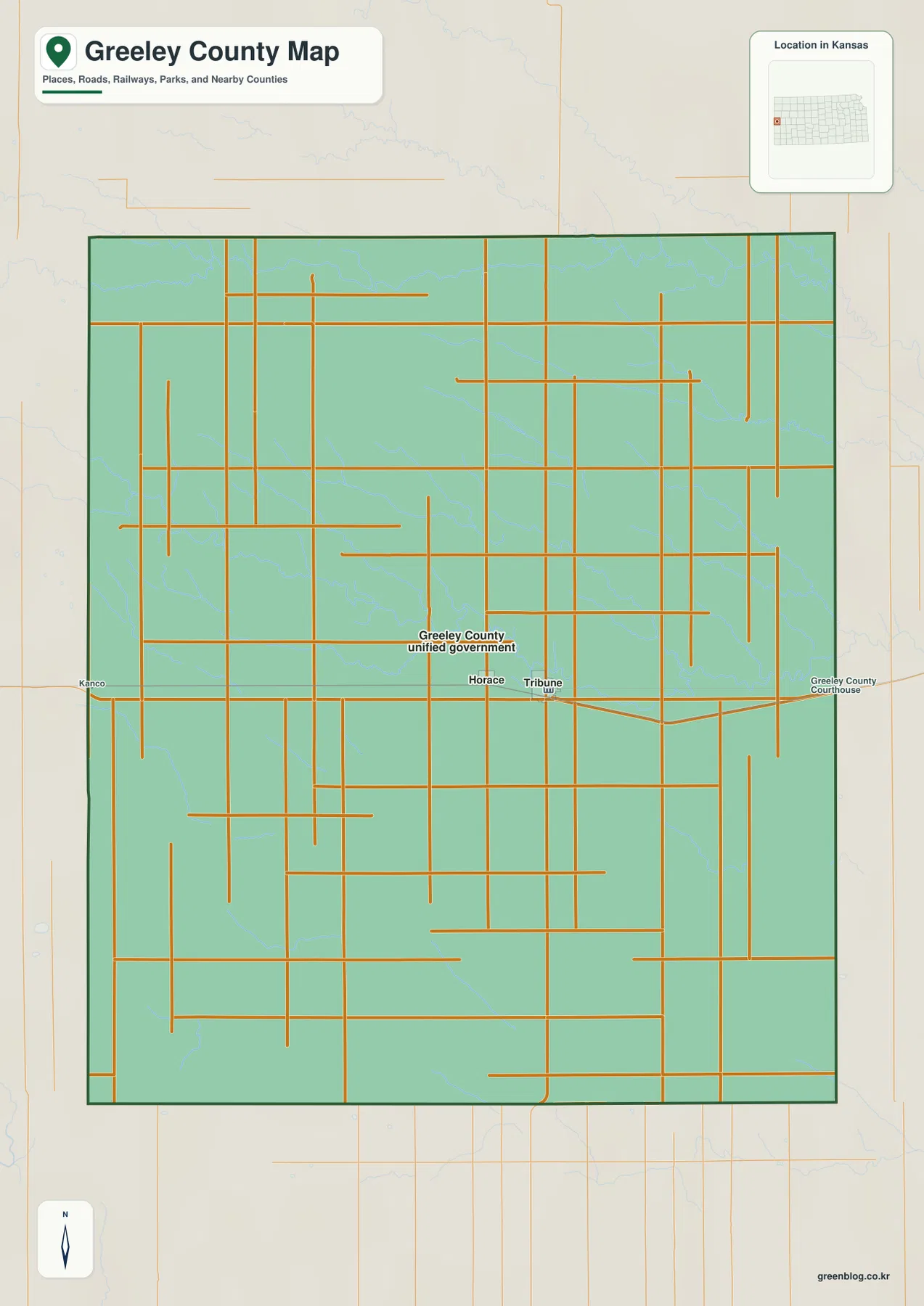
The road grid can make the county look completely flat at first glance, but the terrain maps tell a different story. Creeks wind between the straight roads, and the land steadily drops from west to east. The general map is intended for county-scale orientation rather than live navigation, so current construction, unpaved-road conditions, winter weather, and high-wind travel issues should be checked with up-to-date sources.
Tribune, Horace, and the Unified Government label
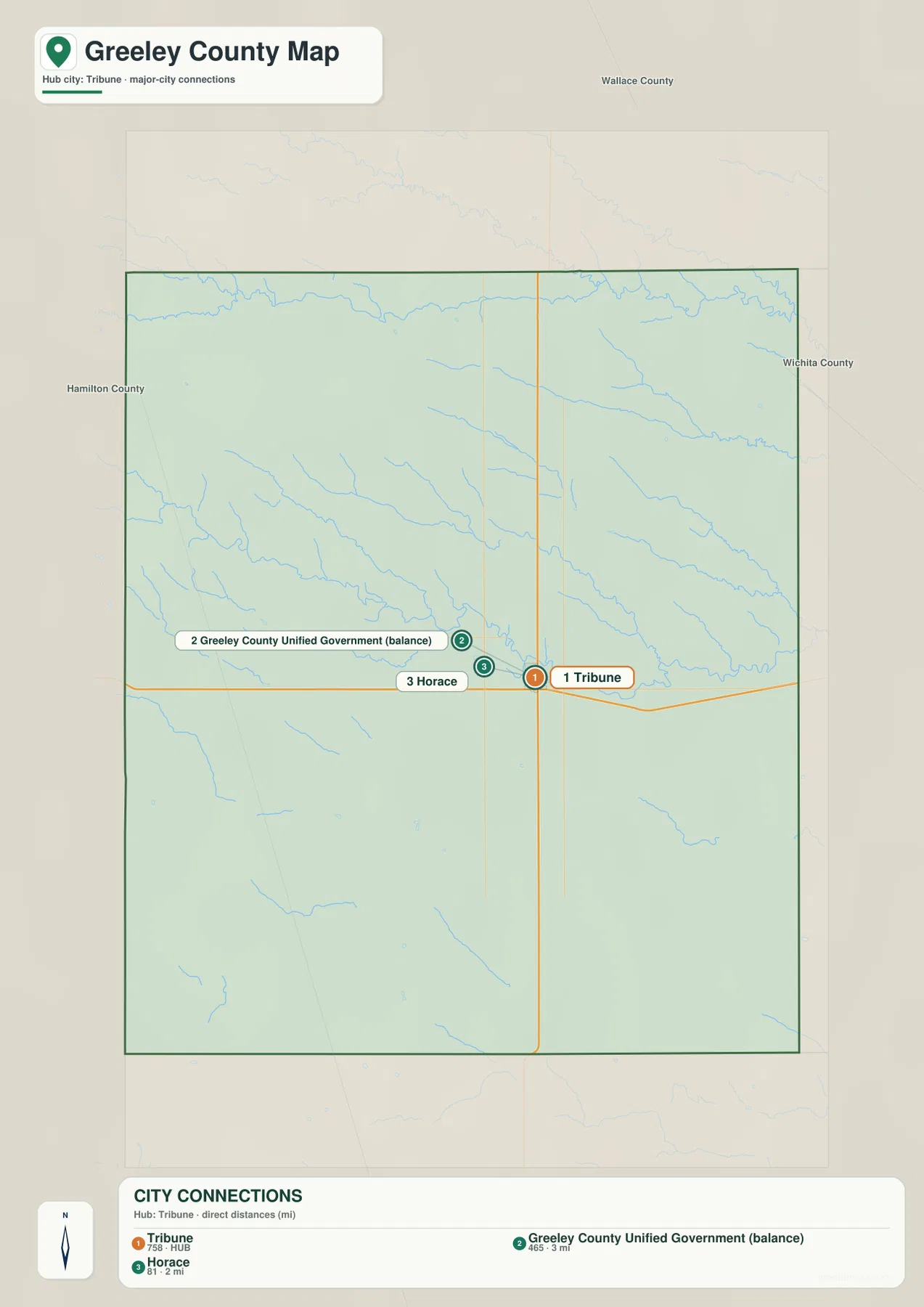
The city connection map uses Tribune as the hub and places Horace about 2 miles to the west in a straight line. Their close spacing makes the two communities easy to locate together. The map also contains a separate entry labeled “Greeley County Unified Government (balance),” which can be confusing if it is read as though it were a conventional city.
The official county government explains the distinction. Greeley County and the City of Tribune merged their governments on January 1, 2009, while Horace retained its own city council. In Census-style geography, the “balance” label refers to the portion of the consolidated government outside the separately identified place, so it is better understood as an administrative-statistical area than as a third community comparable to Tribune or Horace.
The Kansas Historical Society lists Tribune as the county seat and explains that Greeley County was named for newspaper editor Horace Greeley. The names Tribune and Horace therefore carry an additional historical connection: both recall Greeley and the New York Tribune. This background makes the city map more informative than a simple population ranking.
South Ladder Creek and White Woman Creek across the High Plains
The terrain and water map is dominated by two long drainage features. South Ladder Creek runs along the northern part of Greeley County from west to east, while White Woman Creek crosses the central portion on a similar general course. Both are joined by numerous smaller tributaries that cut shallow valleys into the surrounding uplands.
North and south of White Woman Creek, short branching channels create a delicate network that is easy to miss on the general road map. Chalk Creek is labeled outside the county to the northeast, but inside Greeley County the two primary creek systems provide the clearest structure. There are no large reservoirs or broad river channels dominating the map, so small valleys become especially important for reading the terrain.
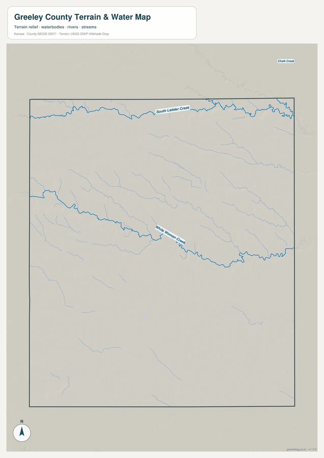
This map is a geographic reference rather than a live hydrology product. Small western Kansas streams can vary greatly with precipitation and season, so current flow, flood conditions, or water quality should be checked with USGS or responsible local agencies. Here, the creek network is most useful for showing how drainage cuts through an otherwise broad and open High Plains surface.
A 1,035–1,205 meter drop from western uplands to eastern valleys
The elevation map shows an actual county range of approximately 1,035 to 1,205 meters and a mean elevation near 1,118 meters. Brown and orange colors dominate the west and southwest, marking the highest broad surfaces. Moving east, the map shifts through yellow and light green into darker green, revealing a clear county-wide decline in elevation.
South Ladder Creek and White Woman Creek form lower green corridors within that broader slope. Their tributaries create smaller fingers of low terrain that reach back into the uplands. The eastern side is especially green because both the overall surface and the creek valleys lie below much of the western county.
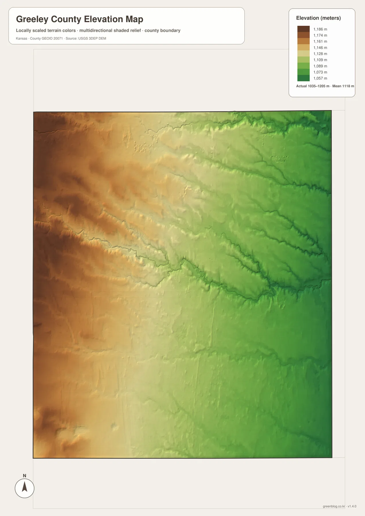
This elevation surface is intended for county-scale comparison rather than survey-grade measurement. It should not be used to establish exact parcel elevations, design drainage, or replace engineering and legal survey data. Its value is visual context: even a county that appears broadly flat can contain roughly 170 meters of elevation difference from one side to the other.
Horace Greeley, Tribune, and the county’s settlement history
The Kansas Historical Society records that Greeley County was established in 1873 and organized in 1888. It was named for Horace Greeley, the founder and editor of the New York Tribune, who became well known for advocating western settlement. The county seat, Tribune, and the nearby community of Horace both echo that naming history.
Settlement increased during the 1880s, and Tribune emerged as the county seat as railroad development reached the area. Kansas Historical Society records from the county-organization period document the formation of local government and confirm Tribune’s central administrative role. The modern map continues to reflect that pattern because county offices, the principal community, and the main road references all cluster around Tribune.
The 2009 creation of the Unified Government added another distinctive chapter. Consolidating the county and Tribune governments reduced duplication while Horace kept a separate city council. For a map reader, that arrangement explains why community geography and administrative geography do not line up as neatly as they might in a conventional county with several independent incorporated cities.
Using the maps for study, printing, and county orientation
For basic orientation, begin with Tribune, Horace, and K-27. For physical geography, follow South Ladder Creek along the north and White Woman Creek across the middle, then compare the same locations with the elevation map. In a sparsely settled county like Greeley, drainage and elevation can be more useful than city labels for distinguishing one part of the landscape from another.
The high-resolution JPG files in the ZIP are better suited than the reduced web previews for printing, classroom projects, local-government explanations, and close inspection of labels. They are useful for county overviews and regional comparison, but current roads, live stream conditions, parcel boundaries, and exact elevations should always be checked against the latest authoritative sources when those details matter.
Frequently Asked Questions
Where is Tribune on the Greeley County map?
Tribune sits slightly north of the county center and serves as the county seat. K-27 runs north and south just east of the community, while Horace lies about 2 miles west in a straight line, making the pair the easiest urban reference for the county.
Is “Unified Government (balance)” a separate city?
Not in the ordinary sense. Greeley County and Tribune operate a consolidated government, and Census-style geography uses the balance label for the remainder of that unified-government area. Horace remains a separate community with its own city council.
Can the 1,035–1,205 meter elevation map be used for surveying?
No. The elevation map is a county-scale visual reference for comparing uplands and creek valleys. Exact parcel elevations, construction design, drainage engineering, and legal surveys require purpose-built data and professional methods appropriate to those tasks.
Map File Information
Download the high-resolution JPG files corresponding to the Greeley County general, city connection, terrain-and-water, and elevation maps in one ZIP archive.
- Included Files: Use only the versions confirmed in the article and supplied images
- File Type: Use the confirmed download contents
- Intended Use: Printing, education, presentations, and map-based projects
Related Maps
Sources and references
- Unified Greeley County official website — county government and community information
- Unified Greeley County — Board of Supervisors — consolidated-government structure since 2009
- Kansas Historical Society — Greeley County, Kansas — county seat, name origin, and local history
- U.S. Census Bureau TIGER/Line — boundary, road, and geographic data resources
- USGS National Hydrography — hydrography and stream-network data information
- USGS 3D Elevation Program — elevation data information
Green Map creates custom-edited map images using open geographic data sources such as geoBoundaries, Natural Earth, OpenStreetMap, and government open data.
These maps are edited visual materials, not raw data files, and are provided for education, documents, presentations, and graphic reference.