Clarke County is in southern Iowa, and Osceola provides the clearest starting point for understanding its road network, communities, waterways, and relief. U.S. 34 crosses the county from west to east through Osceola, while I-35 and U.S. 69 add important north-south connections around the county seat. Murray appears west of Osceola and Woodburn to the east, giving the road map a simple town-to-town frame. The maps on this page separate those subjects so labels remain readable, and the same map subjects are available as high-resolution JPG files in the download box below.
The county becomes more interesting when transportation is compared with water and elevation. The terrain-and-water map labels White Breast Creek, South White Breast Creek, Chariton Creek, several Long Creek branches, and a group of small lakes near Osceola. The elevation map then shows a broad contrast between higher western ground and lower terrain toward the east, with an actual range of 271 to 373 meters and a mean of 332 meters. Instead of treating each image as a separate illustration, you can use them together to understand why towns, roads, valleys, and lakes occupy the positions shown.
Table of Contents
Osceola sits where the county’s main road directions come together
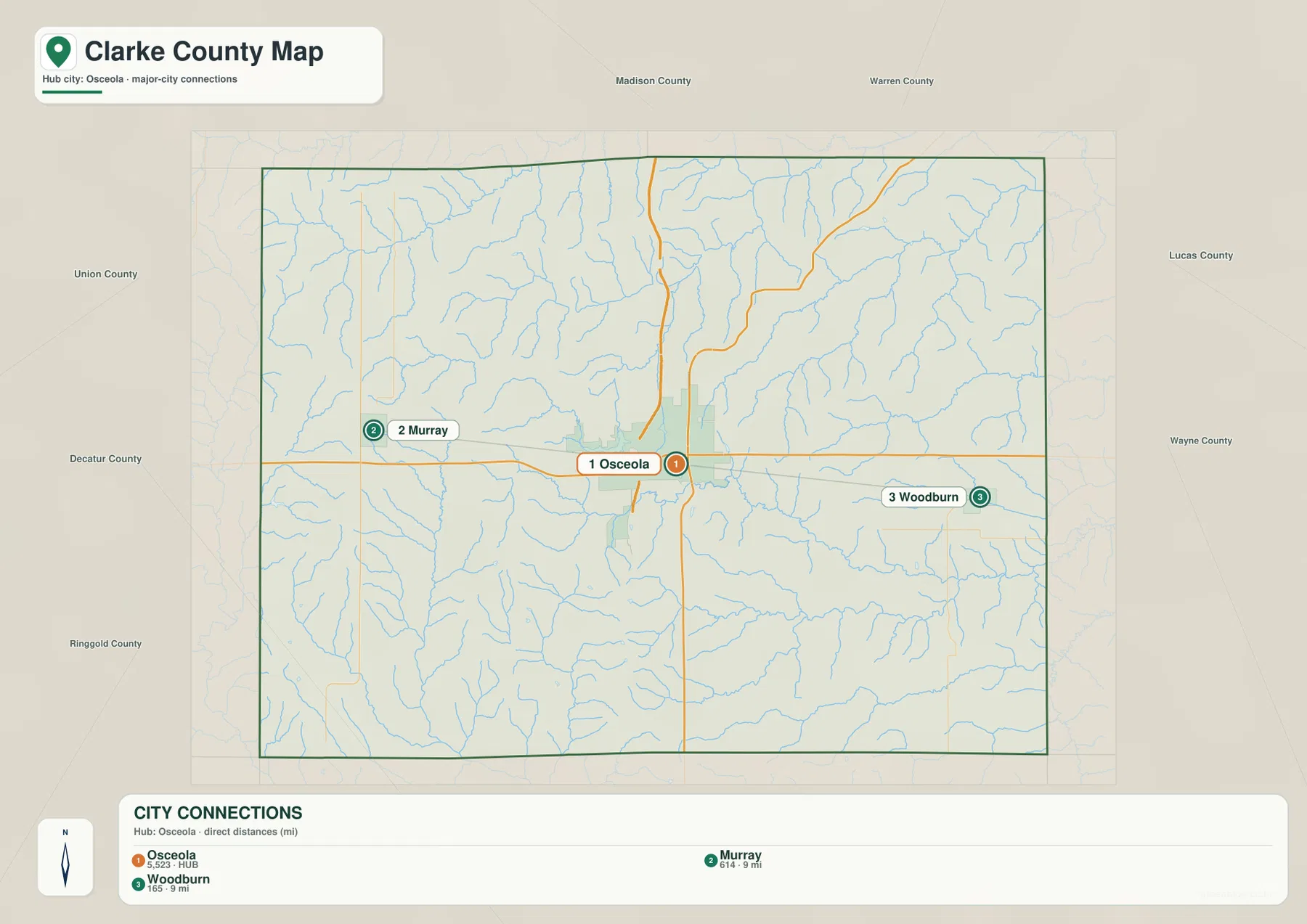
On the general county map, U.S. 34 forms the most obvious east-west route. It approaches Osceola from the Murray side, passes through the city, and continues toward Woodburn and the eastern county line. I-35 is shown on the north-south side of the Osceola area, while U.S. 69 also connects the county in a north-south direction. Seeing those three routes together explains why Osceola is the easiest place to use as a reference point when locating smaller roads or communities elsewhere in Clarke County.
The map also shows a dense network of local roads spreading away from the main highways into rural parts of the county. Murray is clearly marked to the west, Woodburn to the east, and the Osceola urban area occupies the middle of the map. A viewer planning a general route can first locate one of those three communities, then follow the nearest major road before examining the smaller grid. This is much easier than trying to interpret every local line at once.
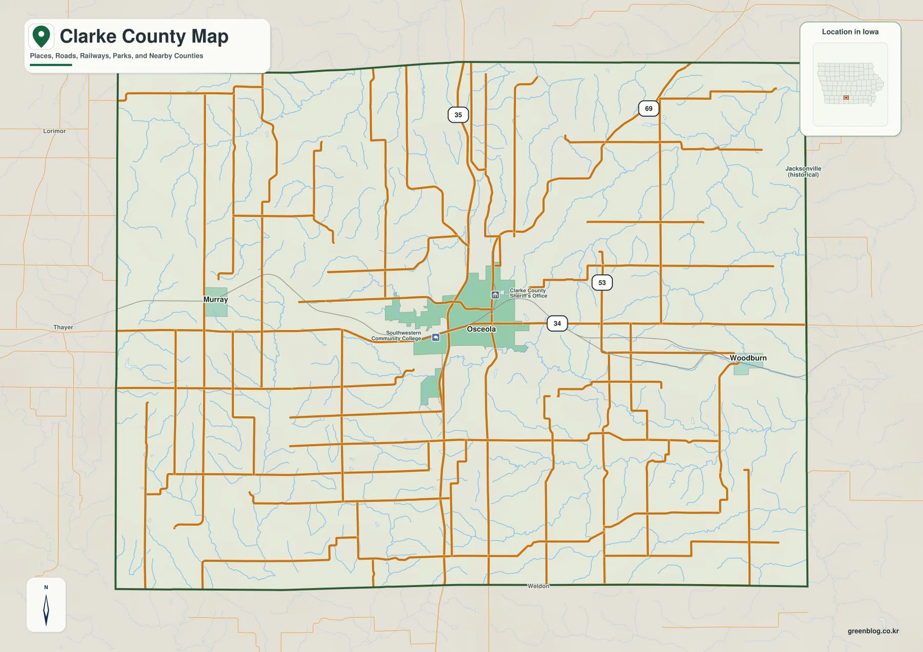
This road map is intended for orientation rather than turn-by-turn navigation. Construction, closures, speed limits, and intersection details can change, so a current road or navigation source should be used for an actual drive. The county outline is also a geographic reference, not a parcel or property-boundary product. Its strength is showing how the principal communities and larger routes fit together across the county.
White Breast Creek links the Osceola lake area with the eastern half of the county
The terrain-and-water map brings a different set of names into focus. West Lake, East Lake, Grade Lake, and Q Pond are clustered near the middle of the county around the Osceola area. White Breast Creek runs away from that central lake area toward the east and southeast, while South White Breast Creek and Chariton Creek appear farther south. On the western side, East Long Creek and West Long Creek form prominent named channels, and South West Creek lies farther north. South River is labeled near the northwest edge.
Those names make the water map especially useful when a road map feels too busy. Rather than following highways, the eye can trace blue channels and compare them with the small lakes around Osceola. The official Clarke County parks material gives additional local context for East Lake, which is associated with East Lake Park on the outskirts of Osceola, and county history material describes a long local connection between East Lake, West Lake, and community water needs. The map itself remains the best source for seeing where the named features lie relative to one another.
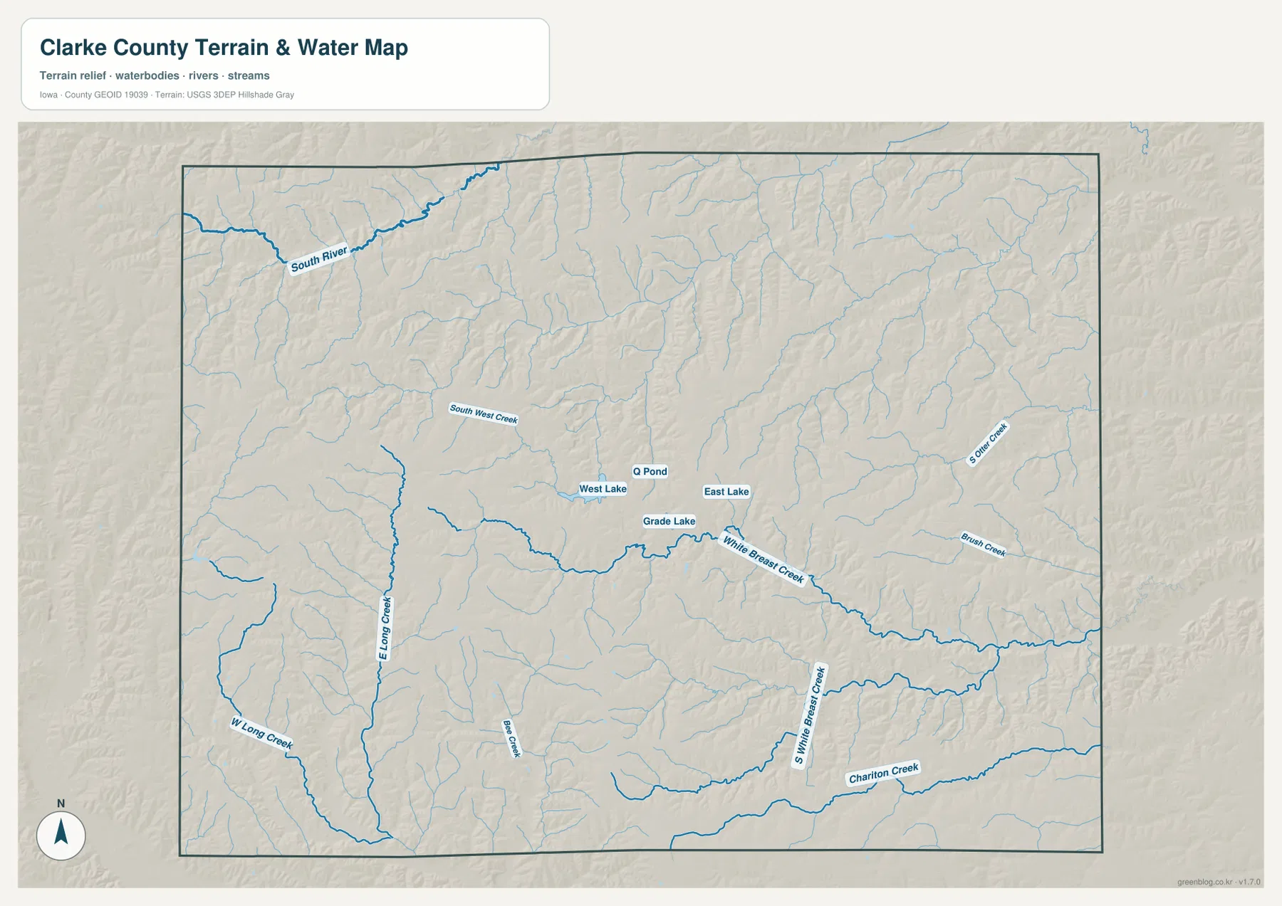
The blue lines should be treated as a geographic water reference, not as a flood-zone, legal-boundary, or navigation layer. A creek shown here may cross many private and public properties, and the map does not indicate current flow, depth, access, or flood regulation. It is most useful for identifying named water features and comparing their positions with roads, towns, and lower terrain.
Murray and Woodburn sit on opposite sides of the Osceola hub
The city-connections map strips away most of the detail and leaves three main markers: Osceola, Murray, and Woodburn. Osceola is the hub in the center, Murray lies to the west, and Woodburn to the east. The legend gives a direct distance of about 9 miles from Osceola to Murray and about 9 miles from Osceola to Woodburn. These are straight-line distances, not driving distances, so they are useful for comparing relative position rather than estimating travel time.
Neighboring county labels make the location easier to place within southern Iowa. Madison and Warren counties are shown to the north, Union County to the west, Lucas County to the east, and Decatur, Ringgold, and Wayne counties around the southern side. The result is a useful regional frame: Clarke County sits between those neighbors, with Osceola near the center and the two smaller labeled cities on opposite east-west sides.
This simplified view is useful before opening the more detailed road map. A visitor unfamiliar with the county can first learn that Murray is west of Osceola and Woodburn is east, then switch to the county map to see U.S. 34 and the local road network. The two maps are therefore complementary: one is a quick location index, while the other supplies transportation detail.
Higher western ridges give way to lower eastern valleys
The elevation map uses locally scaled colors to show relief across Clarke County. Its legend gives an actual range from 271 to 373 meters, with a mean elevation of 332 meters. Brown and tan colors are concentrated across much of the west and southwest, indicating higher ground, while green colors become more common toward the east and northeast. The center of the county contains a mixture of both, showing a gradual change rather than one sharp escarpment.
Narrow green corridors cut through the higher colors in many places. When the elevation map is compared with the terrain-and-water map, many of those lower corridors line up with creeks and valleys. This makes the elevation layer particularly helpful for understanding why the stream network looks so branching and why the eastern half appears lower overall. It also shows that the county is not flat even though the road map can make the landscape look like a simple rural grid.
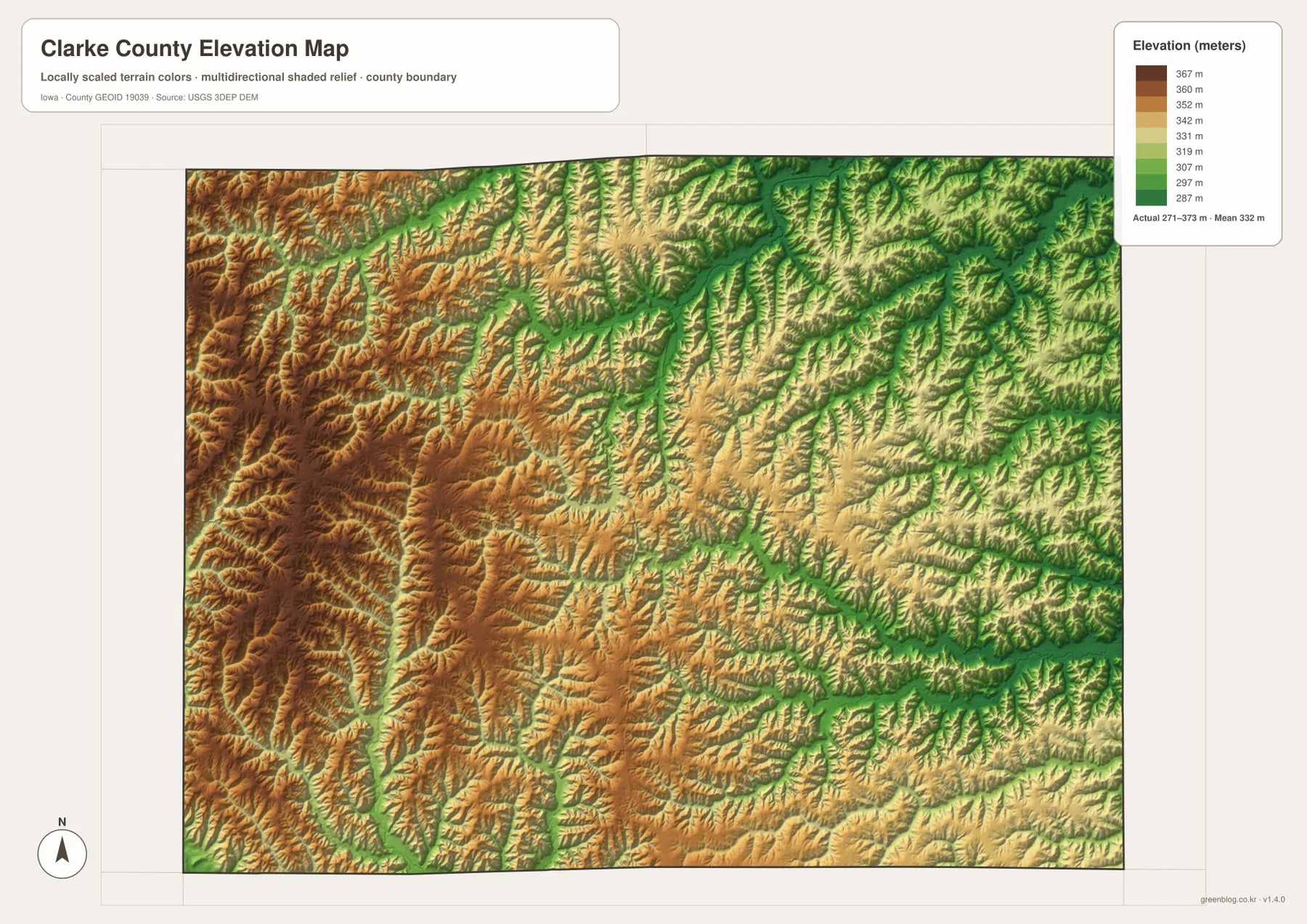
The elevation values are appropriate for county-scale comparison, not for surveying, engineering design, or determining the exact height of a building site. If a project depends on precise elevation, slope, or drainage measurements, use a purpose-specific authoritative dataset. For general geographic study, however, the color contrast gives a clear view of where the county rises and falls.
Reading the roads, lakes, and relief as one county landscape
One practical way to use the set is to begin with Osceola on the road map, then locate the nearby lakes on the terrain-and-water map. East Lake and West Lake become easy to place once U.S. 34 and the Osceola urban area are already familiar. From there, White Breast Creek can be followed toward the eastern side of the county. Switching to the elevation map reveals that much of that eastern side occupies lower terrain than the browner western ridges.
The same method works for the smaller cities. Start with Murray or Woodburn on the city-connections map, use the road map to understand its relationship to Osceola and U.S. 34, and then compare the nearby terrain with the water and elevation layers. Murray sits on the higher western side of the county, while Woodburn is placed toward the lower eastern side. That contrast is easier to appreciate after the town locations are already clear.
Clarke County’s official history notes that the site of Osceola was selected as the county seat in 1851. The modern map still shows Osceola as the most prominent settlement and transportation reference point in the county. That historical note is useful context, but the article does not depend on history to explain the geography: the current map itself makes the central role of Osceola obvious through its road connections, larger urban footprint, and position between the western and eastern parts of the county.
Choose the map that matches the question you are trying to answer
Use the general county map first when the question is about roads, town locations, or the county boundary. It is the best single image for seeing Osceola in relation to Murray, Woodburn, U.S. 34, I-35, and U.S. 69. If the only goal is to compare the positions of the three labeled cities, the city-connections map is faster because it removes most secondary detail and shows the straight-line distances from the Osceola hub.
For rivers, creeks, or lakes, the terrain-and-water map should be the first choice. White Breast Creek, South White Breast Creek, Chariton Creek, East Lake, West Lake, and Grade Lake are all easier to find there than on the road map. For landform questions, the elevation map is more informative because it shows the west-to-east relief contrast and the lower valleys that are hard to notice on a plain transportation map.
The WebP images in the article are sized for quick viewing on the page. The archive below contains the original high-resolution JPG versions of the same four map subjects, which are more suitable for printing, presentations, offline notes, or viewing labels at a larger size. Keeping each subject in a separate file also makes it easier to choose only the information needed for a lesson, report, trip plan, or personal reference.
Frequently Asked Questions
Are the 9-mile Osceola-to-Murray and Osceola-to-Woodburn distances driving distances?
No. The city-connections map labels direct, straight-line distances from the Osceola hub. A road trip may be longer because highways and local streets do not follow a perfectly straight line. Use a current routing source when travel time or actual driving mileage matters.
Which map is best for locating East Lake, West Lake, and White Breast Creek together?
The terrain-and-water map is the clearest choice. It labels East Lake, West Lake, Grade Lake, White Breast Creek, South White Breast Creek, Chariton Creek, and several smaller channels on the same image. If you also need nearby roads, compare it with the general county map rather than expecting the water layer to serve as a navigation map.
Can the 271–373 meter elevation range be used for construction or land surveying?
No. The elevation map is designed for county-scale geographic comparison. It shows where the terrain is generally higher or lower, but it is not a survey or engineering product. Use authoritative site-specific elevation data when a decision depends on precise height or slope measurements.
Map File Information
Download the original high-resolution JPG versions of the county map, city-connections map, terrain-and-water map, and elevation map shown on this page.
- Included Files: 4 high-resolution JPG maps
Related Maps
Sources and references
These official sources provide county context and authoritative background for local roads, waterways, and elevation information.
- Clarke County, Iowa official website
- History of Clarke County
- Clarke County Parks and Public Areas
- Iowa DOT Primary Route Descriptions
- USGS National Hydrography
- USGS 3D Elevation Program
These maps are intended for geographic reference and general understanding. They do not replace current road-control notices, flood-regulation products, property or parcel records, land surveys, or engineering-grade elevation data. When an official decision depends on a current or precise measurement, consult the responsible agency’s source material.
Green Map creates custom-edited map images using open geographic data sources such as geoBoundaries, Natural Earth, OpenStreetMap, and government open data.
These maps are edited visual materials, not raw data files, and are provided for education, documents, presentations, and graphic reference.