Hodgeman County sits in southwestern Kansas, and Jetmore is the easiest place to begin. It is the county seat and largest city, while Hanston is the smaller eastern community. K-156 links the two areas, and U.S. 283 runs south from Jetmore. The county is mostly rural, but its creek valleys and strong west-to-east drop in elevation give the landscape more variation than the road grid first suggests. High-resolution JPG versions of the maps are available together in the ZIP box below. High-resolution map files are available for download in the section below.
Buckner Creek is the county’s main natural reference. It crosses the central area in a long low valley, while the Pawnee River shapes the northwest and Sand Creek cuts through the northeast. Elevation ranges from about 637 to 815 meters with a mean near 725 meters, so the western side stands well above the greener eastern drainage country.
The Kansas Historical Society places Hodgeman County at the meeting of the High Plains and Smoky Hills. Jetmore began under the name Buckner during a disputed county-seat era, and Hanston grew from a Santa Fe Railway station and shipping point. Those stories fit the map because both communities developed where travel and local services could concentrate within a sparsely settled county.
Table of Contents
Jetmore provides the simplest road reference
Jetmore lies close to the county center and gives travelers the clearest reference for the local road system. K-156 heads east toward Hanston, while U.S. 283 continues south from the Jetmore area. K-200 and a wide grid of county roads serve the western and southern agricultural lands, but the main structure is easiest to understand from the Jetmore junction.
Hanston sits east of Jetmore along the principal settlement corridor. Burdett appears beyond the eastern boundary in Pawnee County, while Orwell is a smaller reference in the southeast. Dungans Crossing in the northeast is notable because the place name is tied to older travel across the Pawnee River area.
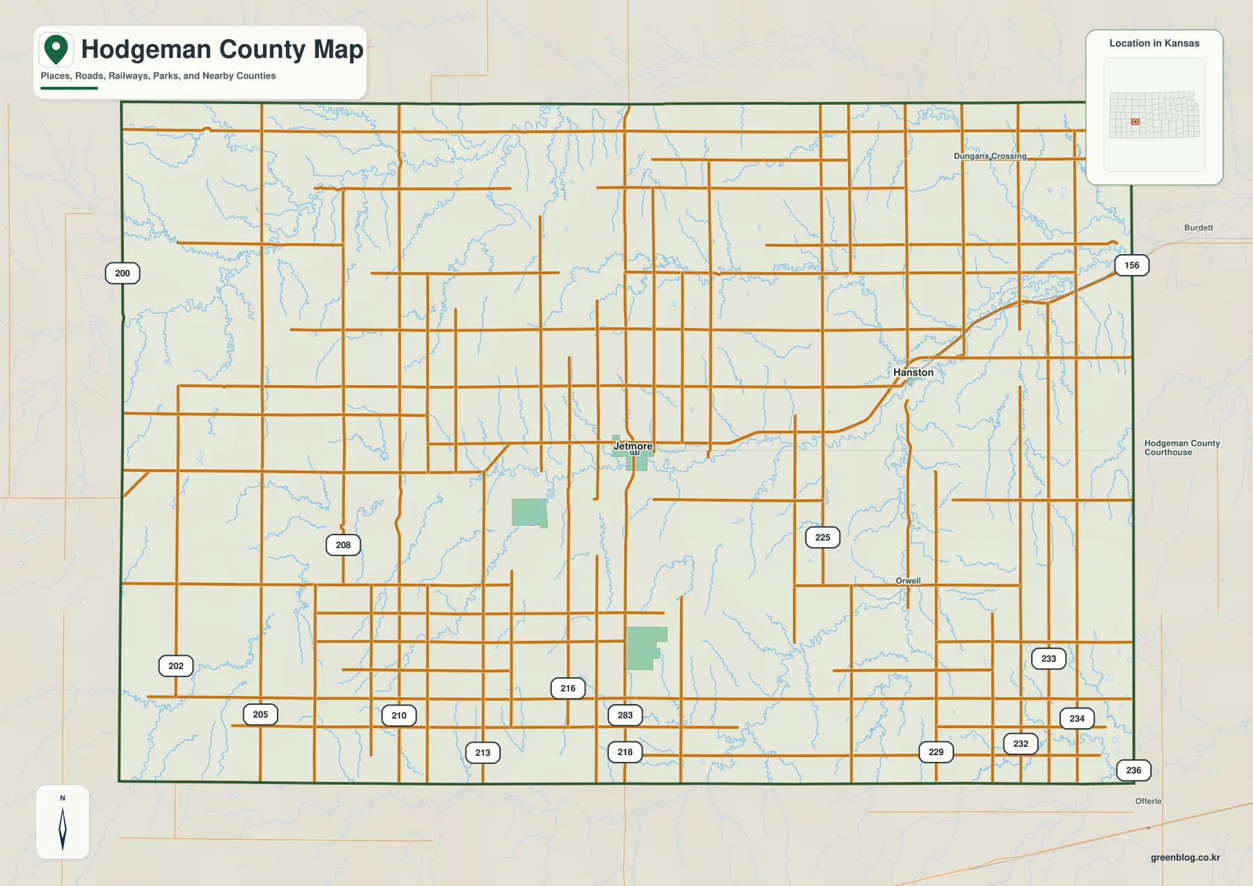
The straight road grid can make the county look almost featureless, but creek crossings become more frequent toward the east and north. Those valleys explain why local roads do not always follow a perfect rectangular pattern. This map is best used for county-scale orientation, while current construction, winter weather, and unpaved-road conditions should be checked separately.
Two towns carry most of the county’s urban activity
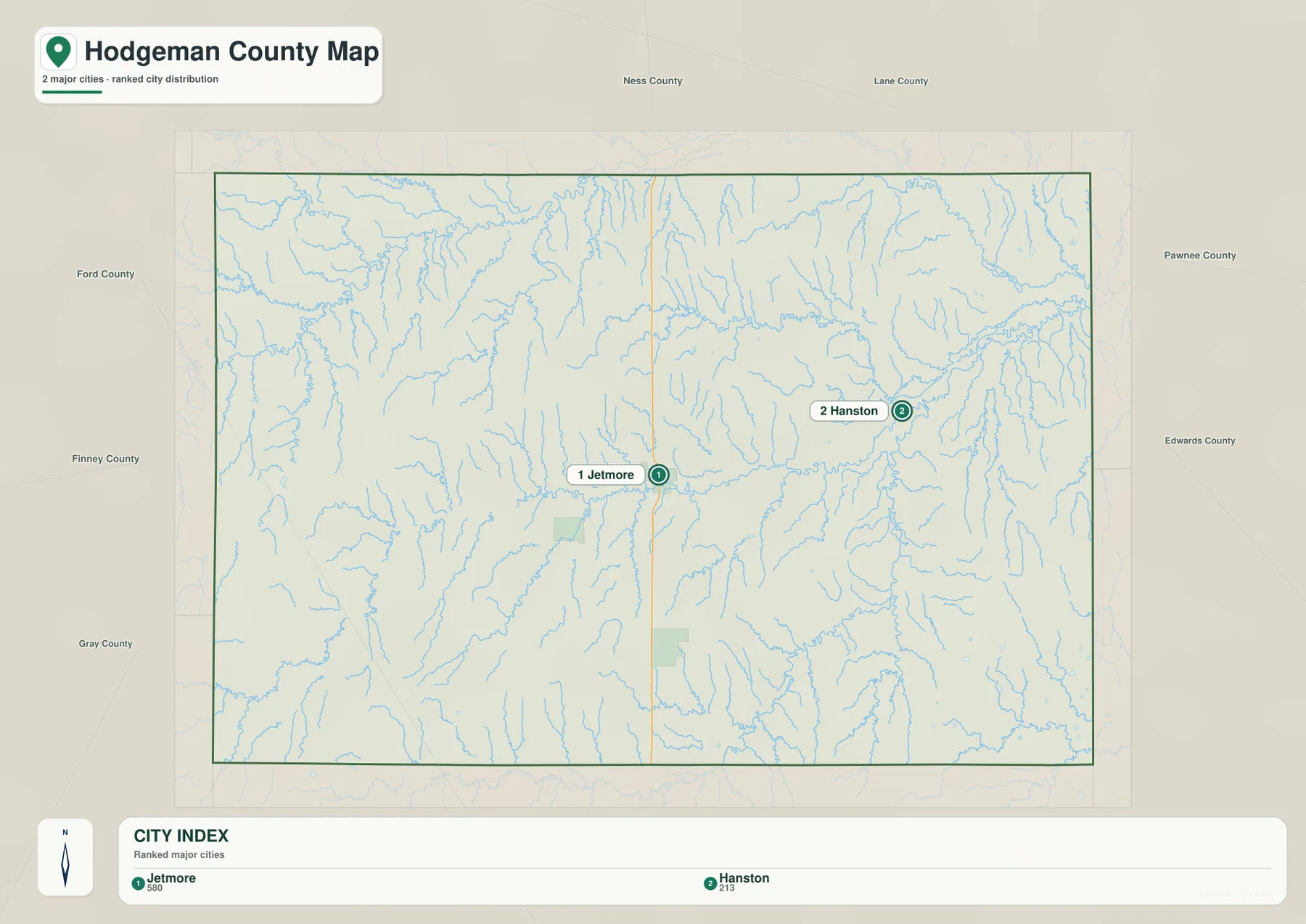
The city distribution map contains only Jetmore and Hanston as the ranked major communities. Jetmore is shown with 580 residents and Hanston with 213 in the source used for the map. Those numbers can change over time, but the settlement pattern is stable: nearly all visible urban concentration is found in these two places.
Jetmore holds the county’s administrative functions, and Hanston gives the eastern farming area a second local center. Between them, Buckner Creek and its tributaries cross broad agricultural land. Pairing the city map with the water map makes the county’s sparse settlement pattern easier to understand because the communities sit within a landscape of low valleys and broad uplands.
Jetmore’s role grew from an early county-seat dispute. The first seat was selected under the name Buckner, and a contested election eventually reached the Kansas Supreme Court. Buckner retained the seat and was later renamed Jetmore, leaving the county’s present administrative center in the same general location.
Buckner Creek ties together the central landscape
Buckner Creek forms the county’s longest continuous low corridor. The valley crosses the middle of Hodgeman County and passes south and east of Jetmore before continuing toward the Hanston side. Many short tributaries descend into it, which is why the creek stands out so clearly on both the water and elevation views.
The northwest has a different character. The Pawnee River winds through higher country, with Hackberry Creek and Plum Creek cutting additional valleys into the surrounding uplands. Farther east, Sand Creek creates a deeper northeastern drainage that opens into lower terrain near the county boundary.
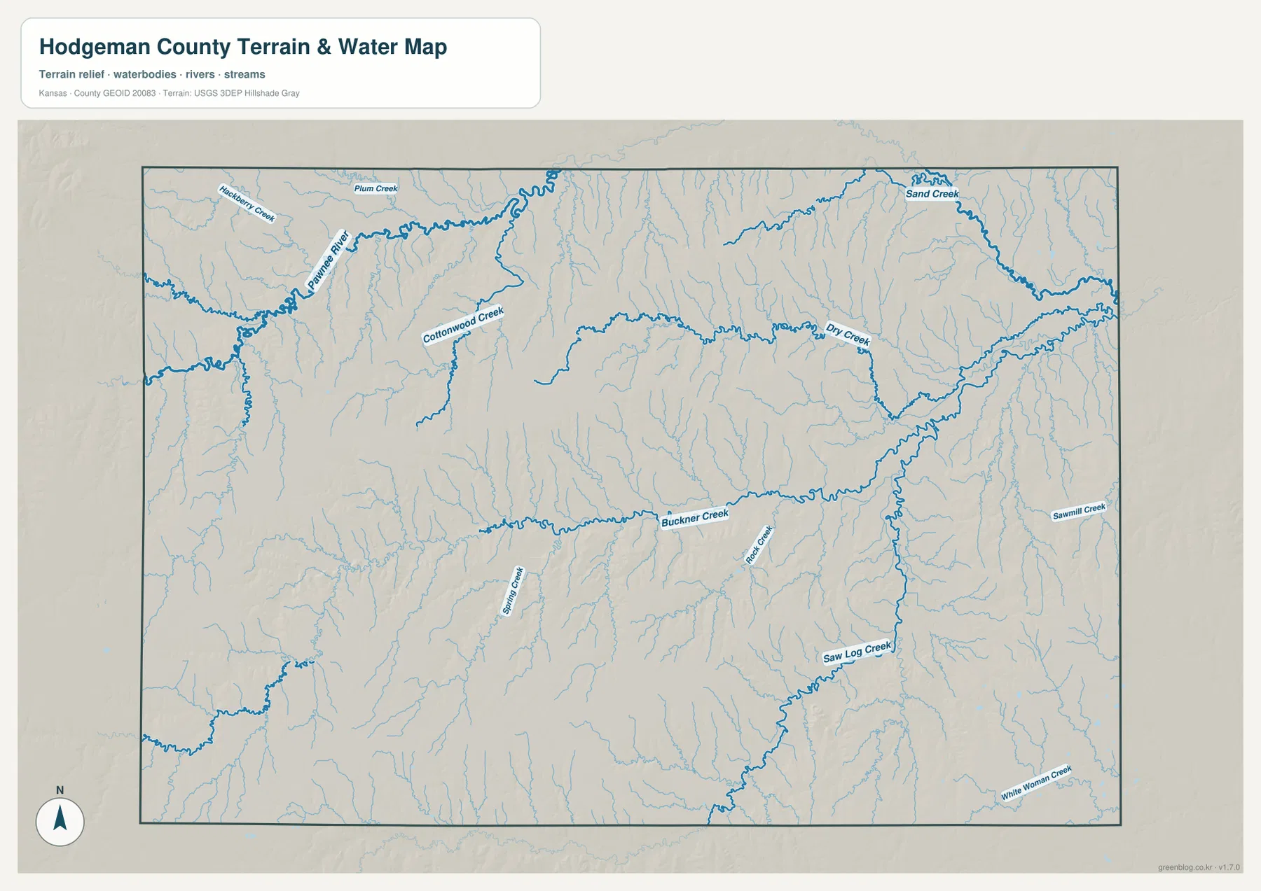
Saw Log Creek is the strongest southeastern drainage, while White Woman Creek reaches the county edge farther south. Spring Creek and Rock Creek divide the central-southern uplands. These channels are useful geographic references, but the map is not a live flood or streamflow product; current conditions should be checked through USGS or local agencies.
The county falls almost 180 meters from west to east
Hodgeman County ranges from about 637 to 815 meters in elevation and averages near 725 meters. The highest brown and orange terrain covers much of the west and southwest. Moving through Jetmore toward Hanston, the colors become progressively greener, showing the county-wide decline toward the east.
Buckner Creek creates a low band across the middle of that slope. Sand Creek and Saw Log Creek occupy even greener eastern valleys, while the Pawnee River cuts deeply into the northwest without changing the fact that western uplands remain higher overall. The map therefore shows both a broad regional slope and smaller local valleys superimposed on it.
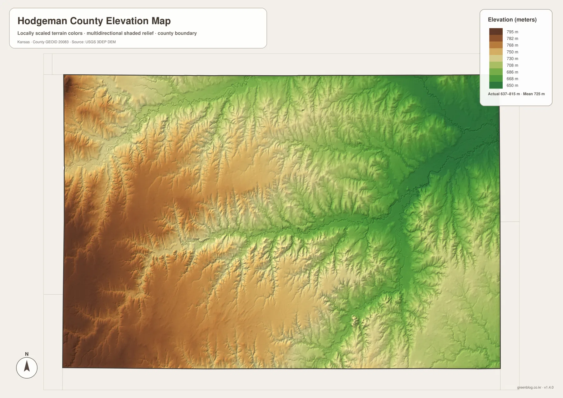
This surface is intended for visual comparison rather than survey-grade measurement. It should not be used to establish exact parcel elevations, design drainage, or replace engineering and legal survey data. Its main value is showing how sharply the county changes from the high west to the lower Hanston and eastern creek country.
A county seat called Buckner became Jetmore
Hodgeman County was organized in 1879, and the first county-seat contest quickly became controversial. According to the Kansas Historical Society, Buckner won the election, but opponents challenged the result and the dispute reached the Kansas Supreme Court. The town remained the seat and was later renamed Jetmore.
The county itself honors Amos Hodgman, a soldier in the Seventh Kansas Cavalry, although the county spelling includes an extra letter. That naming detail, combined with the Buckner-to-Jetmore change, gives the county an unusually layered set of place names.
Jetmore remains the administrative center today and still occupies the most useful position for understanding the road network. Its central location is one reason the city functions so effectively as the first reference on every county-scale map.
Military-road travel and Hanston’s railroad beginning
Before modern highways, the Fort Hays–Fort Dodge military road crossed this part of Kansas. Army scouts and supply wagons used the route, and Pawnee River crossings influenced where travelers could move safely. Dungans Crossing on the modern map preserves a place name associated with that older transportation geography.
Hanston followed a later transportation story. It began in 1878 as Marena, a Santa Fe Railway station and shipping point, and was renamed Hanston in 1902. The town remains the principal eastern settlement, so its early rail role still makes sense when viewed against the modern road map.
Both histories were shaped by terrain. Broad uplands allowed long overland routes, but creeks and river valleys determined practical crossings and stopping points. The terrain maps make those older travel constraints much easier to visualize than a road-only view.
High Plains uplands meet the Smoky Hills
The western side of Hodgeman County has the broad, high character associated with the High Plains, while the eastern side becomes more dissected as the landscape transitions toward the Smoky Hills. The change is obvious on the elevation map, where western browns and oranges give way to eastern greens.
Local geology also influenced settlement. Kansas Historical Society sources describe Greenhorn limestone formed from ancient marine deposits, and early residents used stone for fence posts and buildings where timber was scarce. Those stone features became a recognizable part of western Kansas agricultural scenery.
Horse Thief Canyon southeast of Jetmore adds another example of local relief. Historical accounts describe a rocky area used for picnics and horseback riding, with legends connecting it to cattle rustlers and horse thieves. It is a useful reminder that Hodgeman County contains rugged local features within its broader plains setting.
Using and downloading the map files
For road orientation, start with Jetmore and follow K-156 toward Hanston or U.S. 283 to the south. For physical geography, trace Buckner Creek across the center and compare the Pawnee River, Sand Creek, and Saw Log Creek. The elevation map then explains why the western uplands sit well above the eastern creek country.
The ZIP below contains high-resolution JPG files that are better suited than the web previews for printing, classroom work, local-history projects, and close inspection of labels. For current road conditions, live stream information, parcel boundaries, or exact elevations, use the latest authoritative source for the specific task.
Frequently Asked Questions
Where is Jetmore on the Hodgeman County map?
Jetmore sits close to the county center and serves as the county seat and largest city. K-156 runs east toward Hanston, while U.S. 283 heads south, making Jetmore the easiest first reference for county orientation.
Why is Buckner Creek important in Hodgeman County?
Buckner Creek forms the longest central low corridor in the county and receives many smaller tributaries from the surrounding uplands. On the elevation map, the valley appears distinctly lower than much of the western county.
Can the 637–815 meter elevation map be used for surveying?
No. The elevation map is a county-scale visual reference for comparing uplands and valleys. Exact parcel elevations, construction design, drainage engineering, and legal surveys require purpose-built data and professional methods.
Map File Information
Download the high-resolution JPG files corresponding to the Hodgeman County general, city distribution, terrain-and-water, and elevation maps in one ZIP archive.
- Included Files: Use only the versions confirmed in the article and supplied images
- File Type: Use the confirmed download contents
- Intended Use: Printing, education, presentations, and map-based projects
Related Maps
Sources and references
- Hodgeman County community and government website — Jetmore, Hanston, county services, and local information
- Kansas Historical Society — Hodgeman County, Kansas — county-seat history, Hanston railroad background, High Plains, and Smoky Hills context
- U.S. Census Bureau TIGER/Line — boundary, road, and geographic data resources
- USGS National Hydrography — hydrography and stream-network data information
- USGS 3D Elevation Program — elevation data information
Green Map creates custom-edited map images using open geographic data sources such as geoBoundaries, Natural Earth, OpenStreetMap, and government open data.
These maps are edited visual materials, not raw data files, and are provided for education, documents, presentations, and graphic reference.