Download the high-resolution A3 JPG ZIP for the Houston County Tennessee Map directly from this page; it contains the county, city, water, and elevation maps shown below. Erin is the county seat, Tennessee Ridge is the larger ranked city on the supplied city layer, and the Tennessee River forms the major water reference along the western side. Between the river and the eastern county edge, short ridges and creek valleys shape the road network.
The county becomes much easier to understand when Erin and Tennessee Ridge are treated as inland anchors rather than as isolated town dots. West of them, the terrain falls toward the river and broad low valleys. East and southeast, the landscape rises into rolling ridges cut by Gillies Creek, Willow Creek, and smaller branches. The base road map, water map, and elevation layer all reflect the same change from river-side lowland to interior hills.
Table of Contents
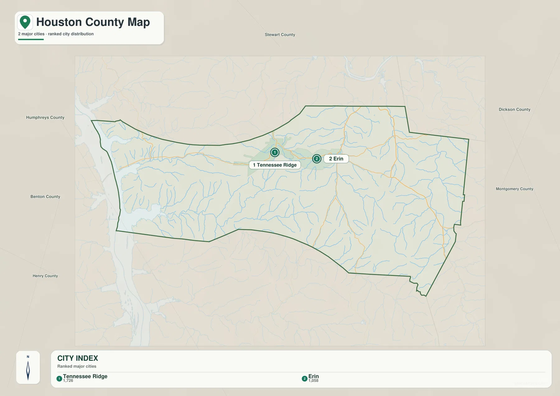
Tennessee Ridge ranks first, while Erin serves as the county seat
The city map ranks Tennessee Ridge at 1,726 residents and Erin at 1,058. Tennessee Ridge therefore carries the larger population label on this layer, but Erin remains the county seat. That distinction matters because population rank and county-government function point to different places.
Both cities sit in the north-central half of the county, with Tennessee Ridge west of Erin. Their positions provide a useful scale for the rest of Houston County: the Tennessee River lies farther west, while the county stretches east and southeast through rolling creek-cut terrain. Surrounding labels such as Stewart, Dickson, and Montgomery counties help with broader orientation without replacing the two main internal references.
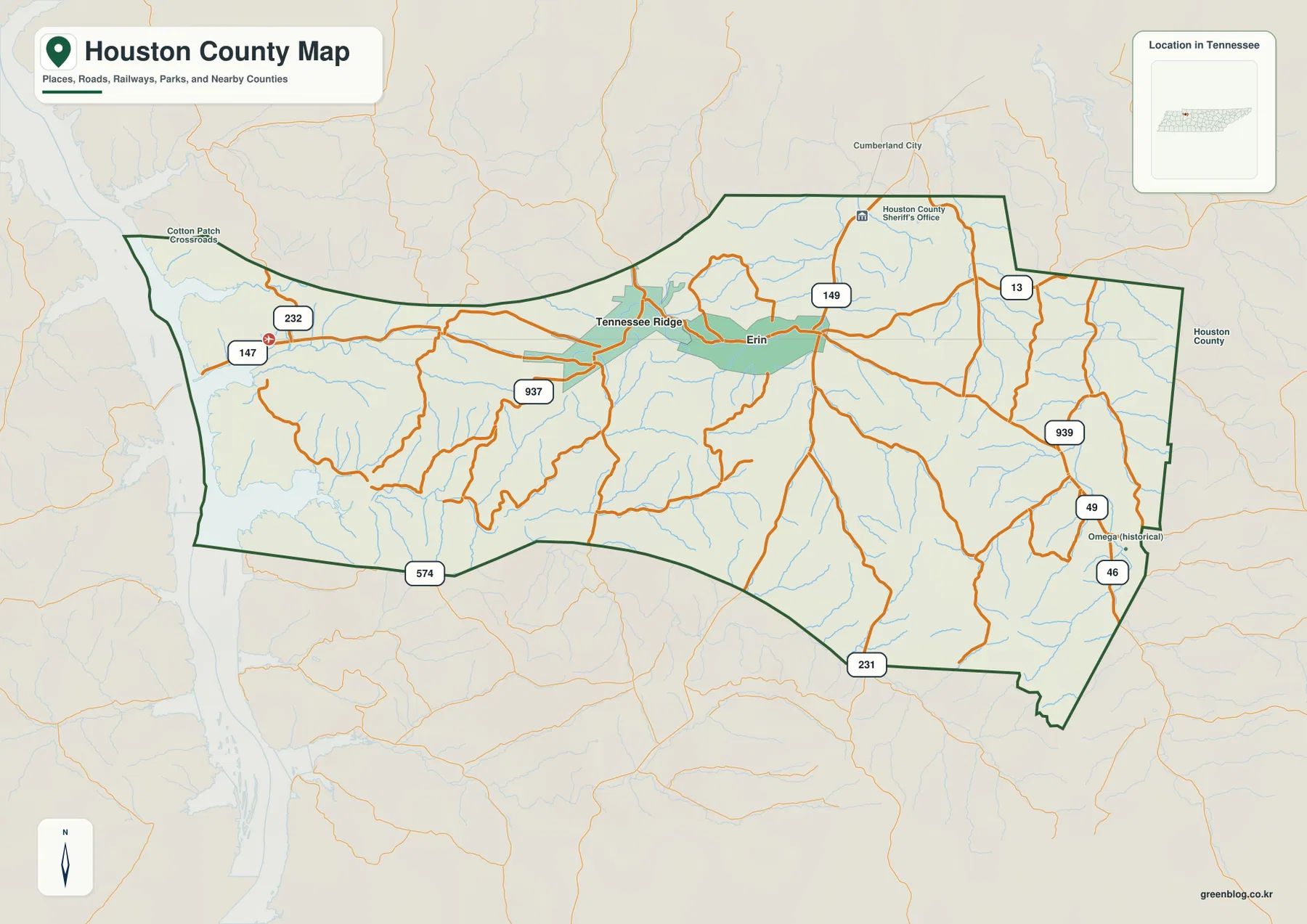
The base map adds the Houston County Sheriff’s Office just northeast of Erin, making the county-seat area easy to locate even when the local road lines become dense. Starting with Erin and Tennessee Ridge, then moving toward the western river edge or southeastern roads, is a much clearer approach than trying to interpret every minor road at once.
Roads leave the river side, meet near Erin, and fan into the southeastern hills
Routes 147 and 232 are clear references near the western edge of the county, while several local roads converge around Tennessee Ridge. Near Erin, Route 149 continues northward. Route 13 serves the northeastern side, and Routes 49 and 46 are prominent farther southeast. Route 231 reaches the southern part of the long eastern extension.
Route 937 appears west of Erin, and Route 574 is visible along the southwestern boundary. The road pattern does not resemble a single highway crossing a flat county. Near the Tennessee River, roads respond to water and lower valleys; farther inland they bend through short ridges and creek corridors. This is why the base map makes more sense when viewed beside the elevation image.
Omega is labeled as a historical place near Routes 49 and 46 in the southeast, while Route 13 provides a convenient reference on the northeastern side. For practical map reading, choose one direction from Erin: west toward Tennessee Ridge and Routes 147–232, northeast toward 149–13, or southeast toward 49–46–231. That keeps the road network manageable.
The Tennessee River lowland gives way to Camp, Whiteoak, and eastern creek valleys
The broad western water body is the strongest feature on the supplied water map and corresponds to the Tennessee River side of Houston County. Camp Creek and Whiteoak Creek extend inland from the west through long low valleys. Their positions line up closely with the green terrain corridors on the elevation map.
Whiteoak Creek is joined by Flint Branch, Lewis Branch, and Long Branch. Together they create a branching valley network in the western half of the county, showing that the land rises into short ridges between each drainage rather than forming a single broad flat river plain. Erin and Tennessee Ridge sit farther inland from the strongest western creek cuts.
The eastern half has its own dense drainage. Gillies Creek is prominent in the northeast-central area, while Willow Creek and Leathermoon Creek run through the east. Bateman Branch, Pond Branch, Salmon Branch, and Dog Branch occupy neighboring valleys, and Brigham Branch provides a northern interior reference. These streams explain much of the irregular relief visible away from the river.
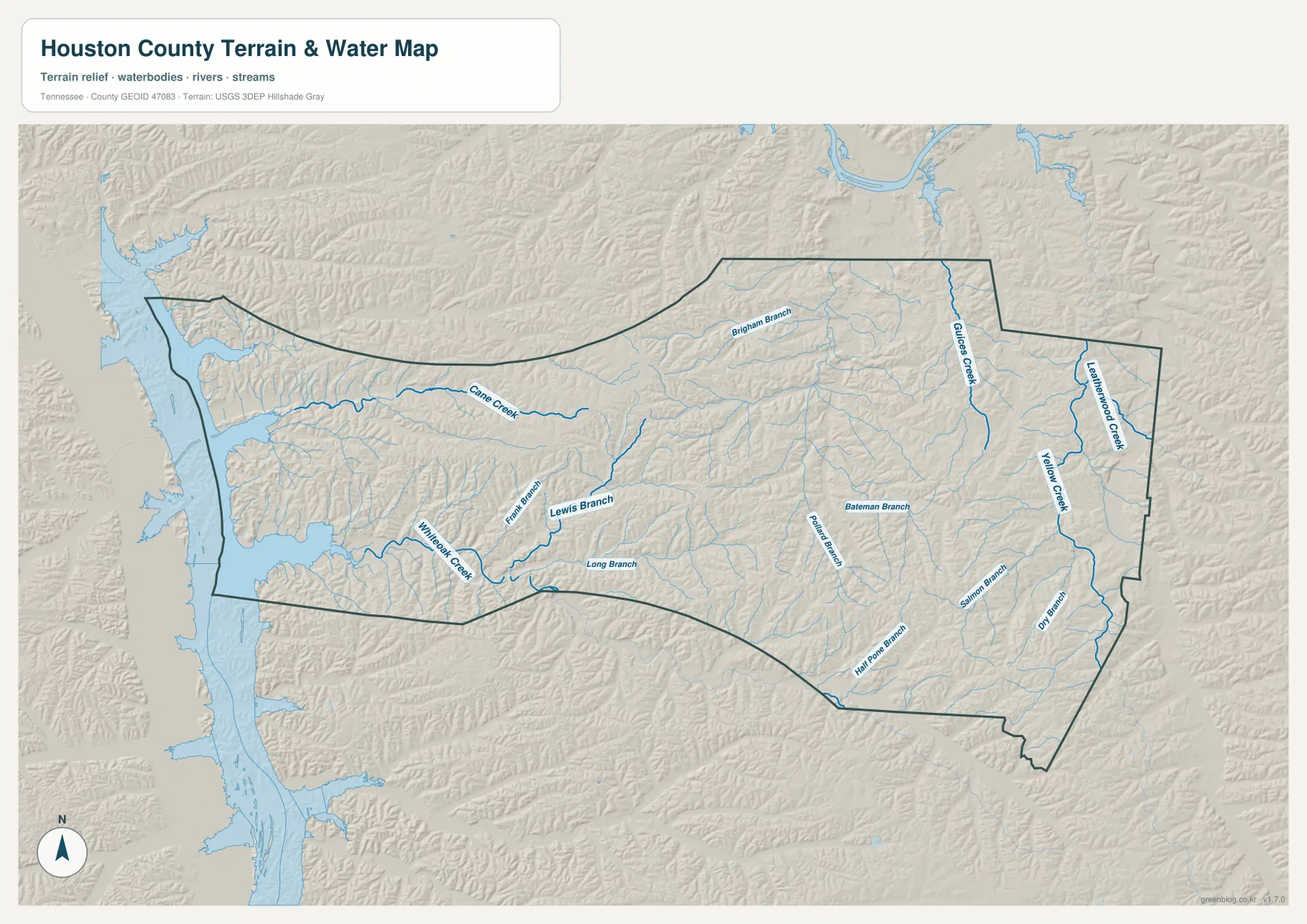
This is a geographic reference layer rather than a live river-conditions product. Tennessee River stage, flood conditions, and access can change, so those questions require current agency information. Here the water layer is used to explain how Erin, Tennessee Ridge, and the road network fit between the western river and the interior creek valleys.
A 108–262 m range shows a low western edge and higher interior ridges
The elevation map shows an actual range of about 108 to 262 meters, with a mean near 176 meters. Dark green low terrain is concentrated along the Tennessee River side and in the deepest creek valleys. Moving into the central and southern interior, the map shifts through yellow-green and tan into broad areas of higher rolling ground.
Higher terrain is especially noticeable through the north-central and west-central interior, where Camp Creek and Whiteoak Creek cut green corridors into brown ridges. The east is more finely broken, with short ridges alternating with the valleys of Gillies, Willow, and Leathermoon creeks. Erin occupies this rolling interior rather than a wide level basin.
The southeastern corner contains some of the strongest brown high ground on the map, while Dog Branch and neighboring streams create narrow lower passages. On the opposite side, the river edge drops into broad low terrain. Houston County is not a mountain county, but the more than 150-meter countywide range is large enough to make the river-to-ridge transition obvious.
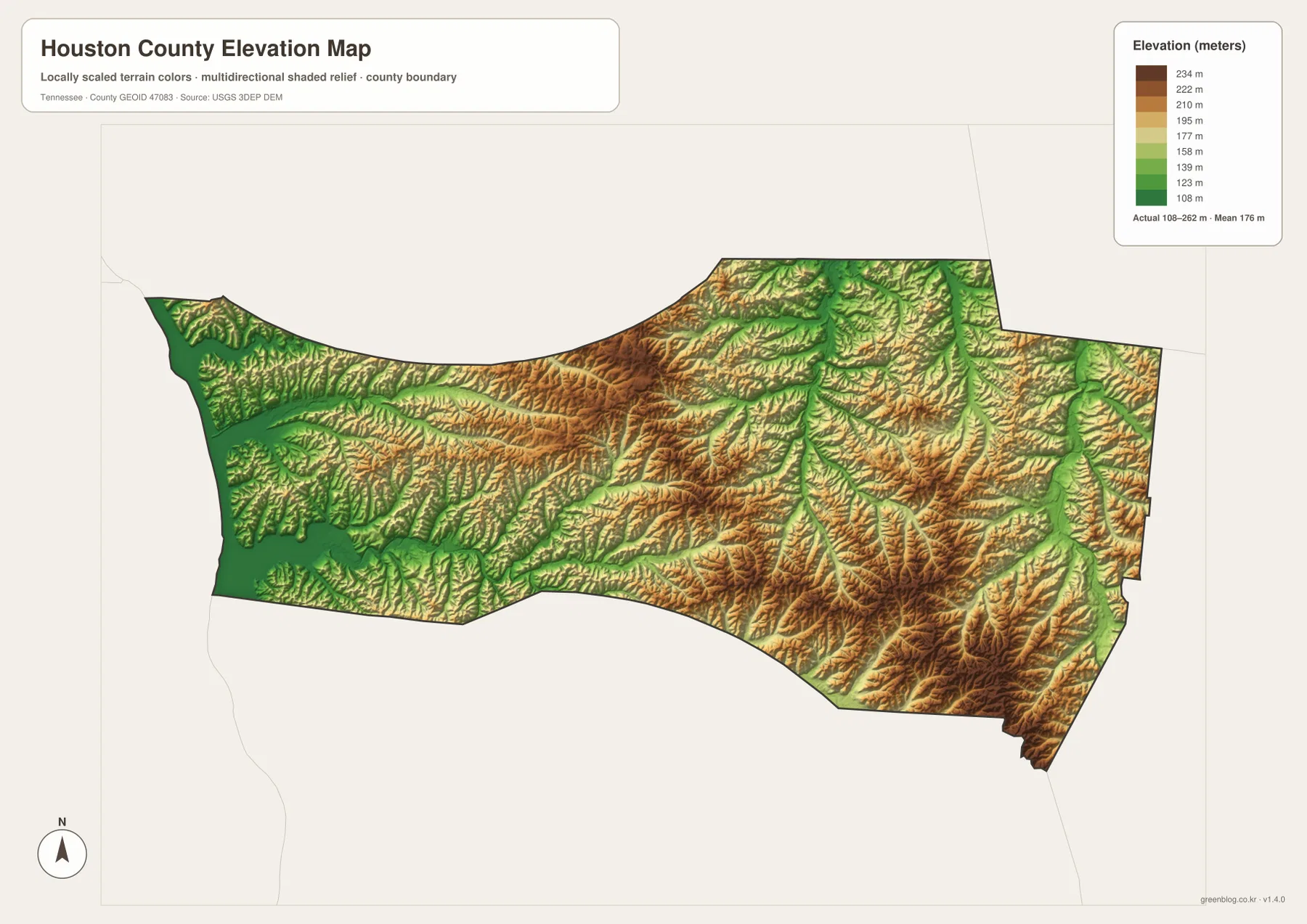
The elevation surface is useful for comparing terrain across the county, not for replacing a surveyed height at a house or parcel. It clearly shows the rise from the western river corridor toward Erin and the way named creeks occupy lower slots between the interior ridges.
Erin and Tennessee Ridge connect the river lowland with the inland hills
The city map reduces Houston County to two strong settlement references. The base map then shows how roads leave those towns in several directions, while the water layer divides the county into the western river-and-creek system and the eastern branch network. The elevation map supplies the final link by showing where those valleys are low and where the ridges rise between them.
A westbound view from Erin passes Tennessee Ridge and moves toward lower river-side terrain. A southeastward view instead follows Routes 49, 46, or 231 into higher rolling ground cut by smaller streams. Those two directions use very different landmarks, even though both begin from the same county-seat area.
Use the city map when Erin and Tennessee Ridge are the main question, the county map for route numbers and smaller place labels, the water map for the Tennessee River and named creeks, and the elevation map when the change from low western ground to interior ridges matters most.
The browser previews are sized for quick reading. The A3 JPG originals are better when route labels around Erin or creek names such as Camp, Whiteoak, and Gillies need to be enlarged or printed. Keeping road notes on the base map and water notes on the hydrography map also prevents the dense branch labels from covering one another.
The ZIP below packages the high-resolution A3 JPG originals used to compare the county boundary and roads, the two ranked cities, the creek network, and the elevation surface. It is suitable for classroom use, presentations, local orientation, or offline reference when the web images are too small.
Frequently Asked Questions
Why is Erin the county seat if Tennessee Ridge is larger on the city map?
The supplied city map ranks Tennessee Ridge at 1,726 residents and Erin at 1,058. Erin is the county seat and government center, while Tennessee Ridge is the larger ranked city on this map, so the two labels describe different roles.
How different is the Tennessee River side from the interior hills?
The elevation map shows roughly 108–262 meters. The western river edge and major creek bottoms are the lowest green areas, while central, southern, and southeastern ridges rise substantially higher within a relatively short distance.
Sources and reference data
County history and local reference material are available from the Tennessee State Library and Archives Houston County fact sheet. Boundary data can be compared with U.S. Census Bureau TIGER/Line, and Tennessee regional river-crossing information is available through Tennessee Department of Transportation ferry services.
For additional hydrography reference, see USGS National Hydrography. Elevation data can be compared with the USGS 3D Elevation Program. The descriptions here follow the places, roads, creek labels, western water, and elevation differences visible in the supplied Houston County maps.
Map File Information
The archive contains the A3 JPG originals for the Houston County road, city, water, and elevation maps used on this page.
- Included Files: County map, city map, water map, elevation map
- File Type: ZIP containing 4 JPG files
Related Maps
Green Map creates custom-edited map images using open geographic data sources such as geoBoundaries, Natural Earth, OpenStreetMap, and government open data. These maps are edited visual materials, not raw data files, and are provided for education, documents, presentations, and graphic reference.