Chautauqua County sits along the southern edge of Kansas, immediately north of Oklahoma. Sedan is the clearest central reference point on the supplied maps, while Cedar Vale lies far to the west and Peru, Niotaze, Chautauqua, and Elgin are spread across the southern and eastern parts of the county. This page brings together a county map, a ranked city map, a terrain-and-water map, and an elevation map. High-resolution JPG versions of the same mapped views are also available in the download ZIP below.
The county becomes easier to understand when its towns are viewed together with the Caney River system and the surrounding hills. Turkey Creek and the Caney River stand out in the west, while North Caney Creek, Middle Caney Creek, and the Little Caney River cut through the eastern half. The supplied elevation map reports an actual range of about 220 to 433 meters and a mean near 294 meters, showing a strong contrast between higher western uplands and lower stream valleys toward the east and southeast.
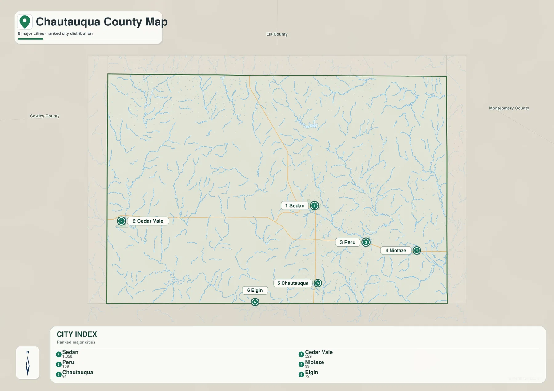
Roads provide another useful way to orient the map. K-99 passes through Sedan and continues south, while U.S. 166 is visible near Peru and Niotaze in the southeast. The communities are not arranged in one compact cluster, so a road or town label alone does not tell the whole story. Comparing those labels with the streams and relief makes it much easier to see why different parts of the county feel separated by broad uplands and branching valleys.
Table of Contents
Using Sedan as the main reference point
On the county map, Sedan is positioned a little east of center and works well as the first place to locate. K-99 runs through the area, giving a clear north-south reference. Cedar Vale is much farther west near the county edge, while Peru and Niotaze are in the southeast. Chautauqua and Elgin sit close to the Oklahoma line, so the southern border is also a useful guide when reading the map.
Peru and Niotaze are associated with the U.S. 166 corridor in the southeast, whereas Chautauqua lies farther west along the southern portion of the county. Elgin appears even closer to the state line. Cedar Vale is separated from these places by a broad western area of hills and drainage lines. Because the communities are spread so widely, the map is most useful when town names, road numbers, and waterways are read together rather than as separate layers of information.
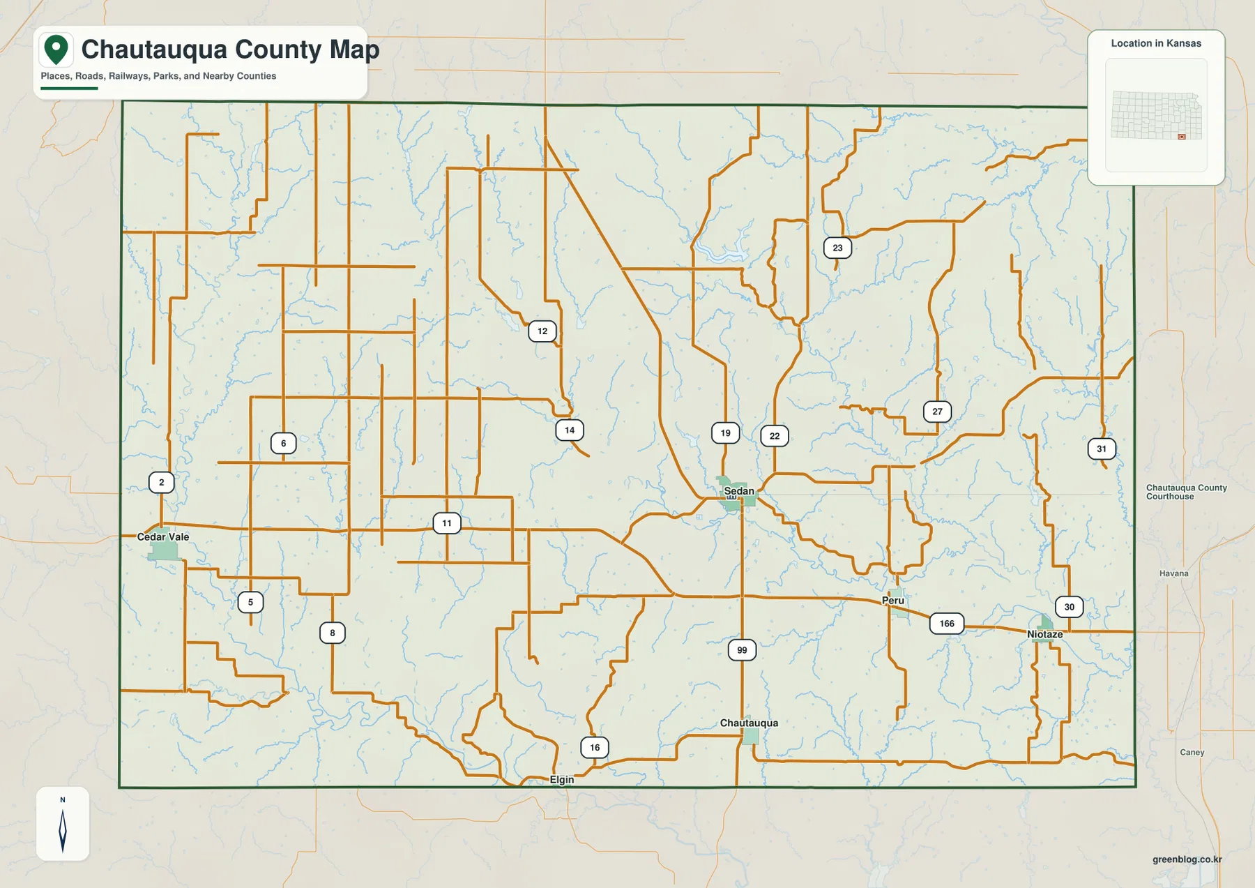
The city-distribution view also labels Elk County to the north, Cowley County to the west, and Montgomery County to the east. Those neighboring counties help place Chautauqua County within southeastern Kansas without adding clutter to the main road view. The map should be treated as a general geographic reference, not as a parcel or legal-boundary product. Property, survey, or legal questions require the current records maintained by the appropriate local or state offices.
A dispersed set of towns rather than one compact cluster
The ranked city map marks six communities and gives a value for each: Sedan 1,050, Cedar Vale 529, Peru 139, Niotaze 99, Chautauqua 91, and Elgin 72. These figures are best used as the values shown on the supplied map for comparing relative size. Anyone who needs the latest official population count should check current Census or local-government data. What the map makes immediately clear is that Sedan and Cedar Vale stand well above the other four labeled places in the displayed ranking.
Location matters just as much as the ranking. Sedan is near the middle of the six mapped communities, Cedar Vale is isolated to the west, and Peru and Niotaze form a closer pair in the southeast. Chautauqua and Elgin lie near the southern edge. The pattern is quite different from a county where several towns line up along one highway, because here the communities occupy separate valleys and road connections across a broad rural landscape.
Comparing the city map with the water map adds useful context. Sedan is surrounded by small drainage lines and lies near Sedan City Lake, while the Peru-Niotaze area is closer to the network formed by North Caney Creek, Middle Caney Creek, and the Little Caney River. Cedar Vale, on the other hand, is associated with the western side of the county where Turkey Creek and the Caney River are prominent. The maps do not prove why each community developed where it did, but they clearly show the physical setting around each town.
The ranked city view is not a travel-time or commuting map. Road conditions, construction, and weather can change the practical distance between places, especially in a county where the towns are widely separated. For route planning, the city map is best used as an orientation tool before checking a current road source or navigation service.
Caney River branches, lakes, and deeply cut local valleys
The western side of the terrain-and-water map is dominated by Turkey Creek and the Caney River. Turkey Creek runs through a long north-south valley, while the Caney River bends along the southwest. Both waterways cut through higher ground that is visible in the shaded terrain. Farther east, Spring Creek and Cedar Creek create additional valleys through the central part of the county, giving the landscape a much more dissected appearance than a simple flat plain.
The eastern half contains an even denser collection of named waterways. North Caney Creek and Middle Caney Creek run toward the southeast, and the Little Caney River becomes a major reference near the eastern edge. Bee Creek and Coon Creek occupy smaller valleys nearby. Their names are similar enough that it is easy to confuse them in text, but the map separates the branches clearly and shows how each one occupies a different strip of lower ground.
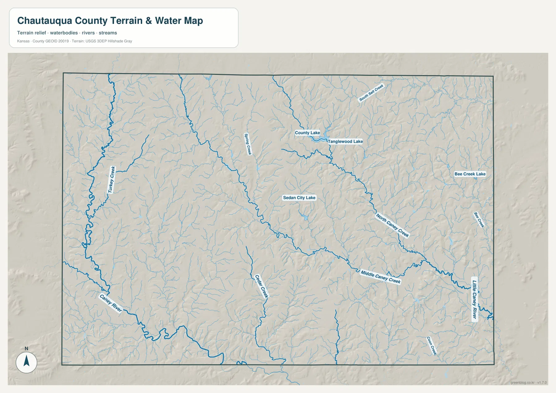
Several lakes also provide useful landmarks. County Lake and Tanglewood Lake are labeled north and northeast of Sedan, Sedan City Lake appears closer to the center, and Bee Creek Lake is shown in the east. These water bodies are helpful for identifying locations, but the map is not intended to provide current water levels, fishing regulations, access permissions, or flood conditions. Those details should come from the agency or property manager responsible for the specific site.
When the water view is compared with the county road map, the frequent changes in road direction make more sense. Many roads cross or skirt branching valleys rather than following a single straight corridor across the county. The relationship is especially noticeable around Sedan and in the southeast, where several streams occupy relatively low ground between ridges. This comparison is useful for understanding the landscape, even though it should not be treated as an explanation for every road alignment.
From 220 to 433 meters: higher west, lower stream corridors
The elevation map reports an actual county range of roughly 220 to 433 meters, with a mean of about 294 meters. Broad brown and orange areas mark higher terrain, especially across much of the western and northwestern side. Green shades are more common along the lower stream corridors in the east and southeast. With more than 200 meters between the mapped low and high values, Chautauqua County has a much stronger relief pattern than a uniformly level landscape.
Long narrow ridges are especially easy to see in the west, where Turkey Creek and the Caney River have lower valleys between the uplands. The central portion is also broken by drainage lines rather than forming one broad flat surface. East of Sedan, the map contains larger areas of low green terrain around the Caney-related streams, but smaller ridges still rise between the branches. That pattern explains why the water network looks so dense in the terrain view.
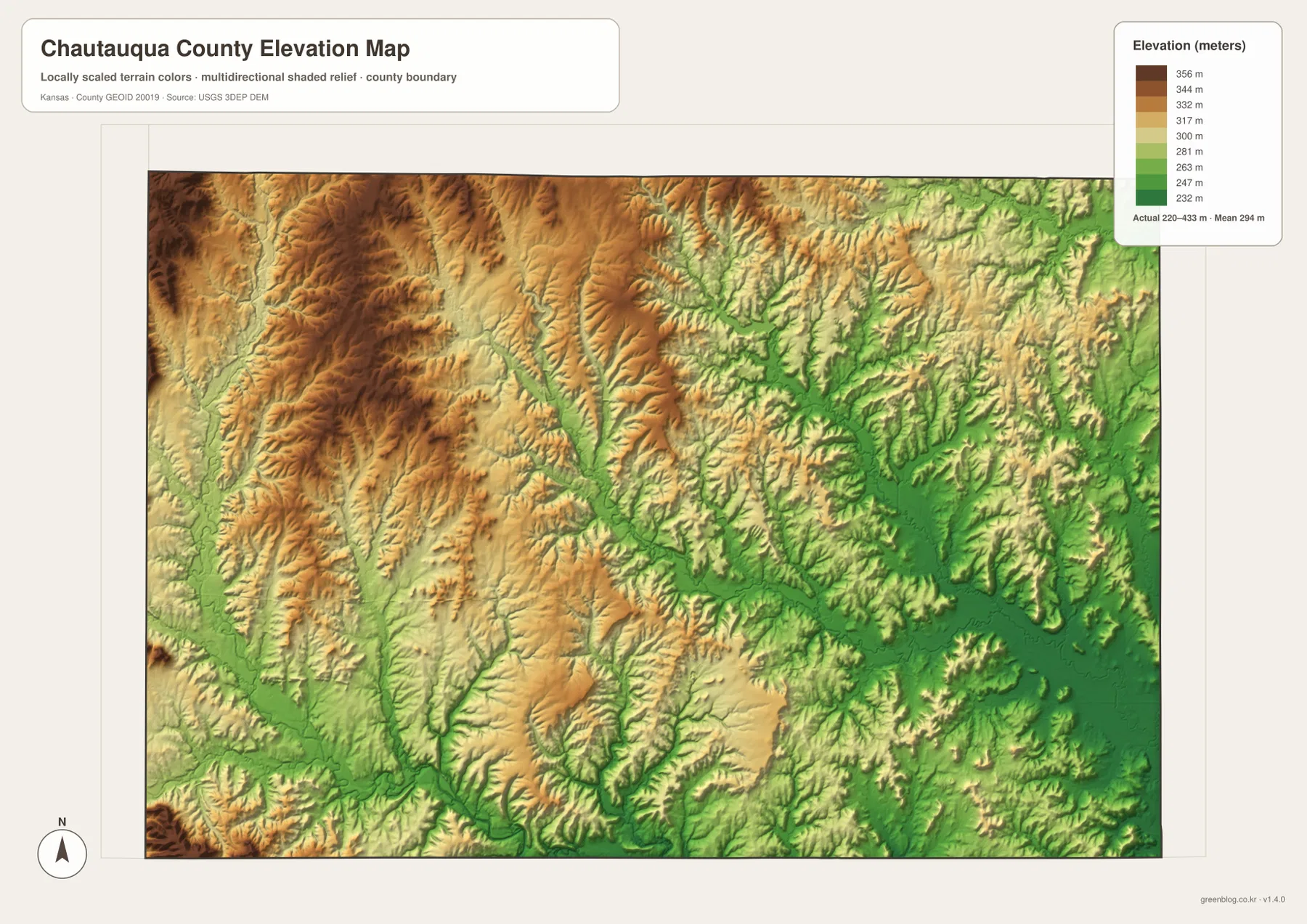
The colored relief is intended for regional comparison rather than survey-grade measurement. Shading makes ridges and valleys easier to recognize, but it can visually emphasize slopes and should not be used to determine a precise property elevation, drainage design, or construction requirement. For work that needs exact elevation values, the underlying USGS 3D Elevation Program data or a professional survey is the better source.
Reading the southeast without losing track of the county as a whole
The southeast can look busy because Peru, Niotaze, U.S. 166, and several Caney-related streams occupy the same part of the county. A simple way to read it is to start at Sedan, trace K-99 southward, and then locate Peru and Niotaze farther east. After the towns are fixed in mind, the water map adds North Caney Creek, Middle Caney Creek, and the Little Caney River. This sequence keeps the drainage labels from becoming a list of unfamiliar names.
The western side is easier to organize around Cedar Vale. Once its distance from Sedan is clear on the city map, Turkey Creek and the Caney River provide natural references on the terrain view. The elevation map then shows why this side of the county has such a different appearance: large areas of higher brown and orange relief are cut by narrow lower valleys. Comparing those three views gives a practical sense of how settlement, water, and topography fit together without requiring technical GIS terminology.
Chautauqua and Elgin are useful southern reference points because both are close to the Oklahoma border. Their position helps keep the state line in view when following local roads or the southern drainage pattern. For a classroom presentation, trip overview, or general county study, beginning with one town and one nearby water feature is often more effective than trying to memorize every label at once.
Choosing and downloading the high-resolution map files
Use the county map when the main goal is to find towns and roads, and choose the ranked city map when relative community size and spacing matter most. The terrain-and-water map is the strongest choice for stream names, lakes, and valley patterns, while the elevation map makes the west-to-east relief contrast easier to see. Looking at the county, water, and elevation views together is especially helpful when you want to understand why a road or town occupies a particular part of the landscape.
The web images are sized for quick viewing, while each original JPG measures 3638 × 2572 pixels. The larger files are better for zooming into smaller creek labels, road numbers, town positions, and relief shading, and they are more convenient for slides, classroom handouts, personal reference, or general printing. The ZIP contains the four JPG files corresponding to the county, city, terrain-and-water, and elevation maps shown on this page.
These maps are designed for general geographic reference. They do not replace current navigation, flood warnings, legal boundary records, engineering plans, or professional surveying. If a task depends on live road conditions, current water levels, or a precise elevation at one site, use the appropriate official source in addition to the downloadable map files.
Frequently Asked Questions
Which map is best for finding Sedan and Cedar Vale?
The county map is the quickest choice. Sedan sits a little east of center with K-99 running through the area, while Cedar Vale is far to the west near the county edge. The ranked city map is useful as a second view if you also want to compare their displayed relative size.
Are the Caney River and Little Caney River shown in the same part of the county?
No. On the supplied terrain-and-water map, the Caney River is prominent in the west and southwest, while the Little Caney River appears along the eastern and southeastern side. North Caney Creek and Middle Caney Creek occupy separate branches between them.
What is included in the download ZIP?
The ZIP contains four high-resolution JPG files matching the county map, ranked city map, terrain-and-water map, and elevation map on this page. Each original is 3638 × 2572 pixels, making small road labels, stream names, and relief details easier to inspect than in the web previews.
Map File Information
Download the high-resolution JPG originals corresponding to the Chautauqua County map, ranked city map, terrain-and-water map, and elevation map shown on this page.
- File Type: ZIP containing 4 JPG files
Related Maps
Sources and reference links
Boundary and general geographic data can be checked through the U.S. Census Bureau TIGER/Line Shapefiles. Waterway information is available from USGS National Hydrography, and elevation data can be reviewed through the USGS 3D Elevation Program. The descriptions on this page are based on the towns, roads, waterways, lakes, and elevation range visible in the supplied Chautauqua County maps.
Green Map creates custom-edited map images using open geographic data sources such as geoBoundaries, Natural Earth, OpenStreetMap, and government open data.
These maps are edited visual materials, not raw data files, and are provided for education, documents, presentations, and graphic reference.