Sully County sits in central South Dakota with a distinctive western edge shaped by Lake Oahe and a broad rural interior centered on Onida and Agar. The county maps on this page are designed to make that geography easy to follow: one view combines the boundary, communities, and roads; another isolates the ranked city markers; the terrain-and-water layer labels creeks and lakes; and the elevation surface shows where the land rises away from the reservoir. The original high-resolution JPG files represented by these WebP previews can be downloaded together from the map file box near the end of the page.
The county government describes Sully County as about thirty miles north of Pierre, organized in 1883, and home to the two communities of Onida and Agar. Onida is the county seat and the courthouse location. The same official page lists a 2020 population of 1,446 and a total area of 1,070 square miles. Those figures fit what the maps show visually: a large county with only a small number of concentrated settlement points, long stretches of open land, and a western shoreline that makes the county outline far less regular than its straight northern, eastern, and southern sides.
Table of Contents
US 83 links Onida and Agar while Lake Oahe reshapes the western boundary
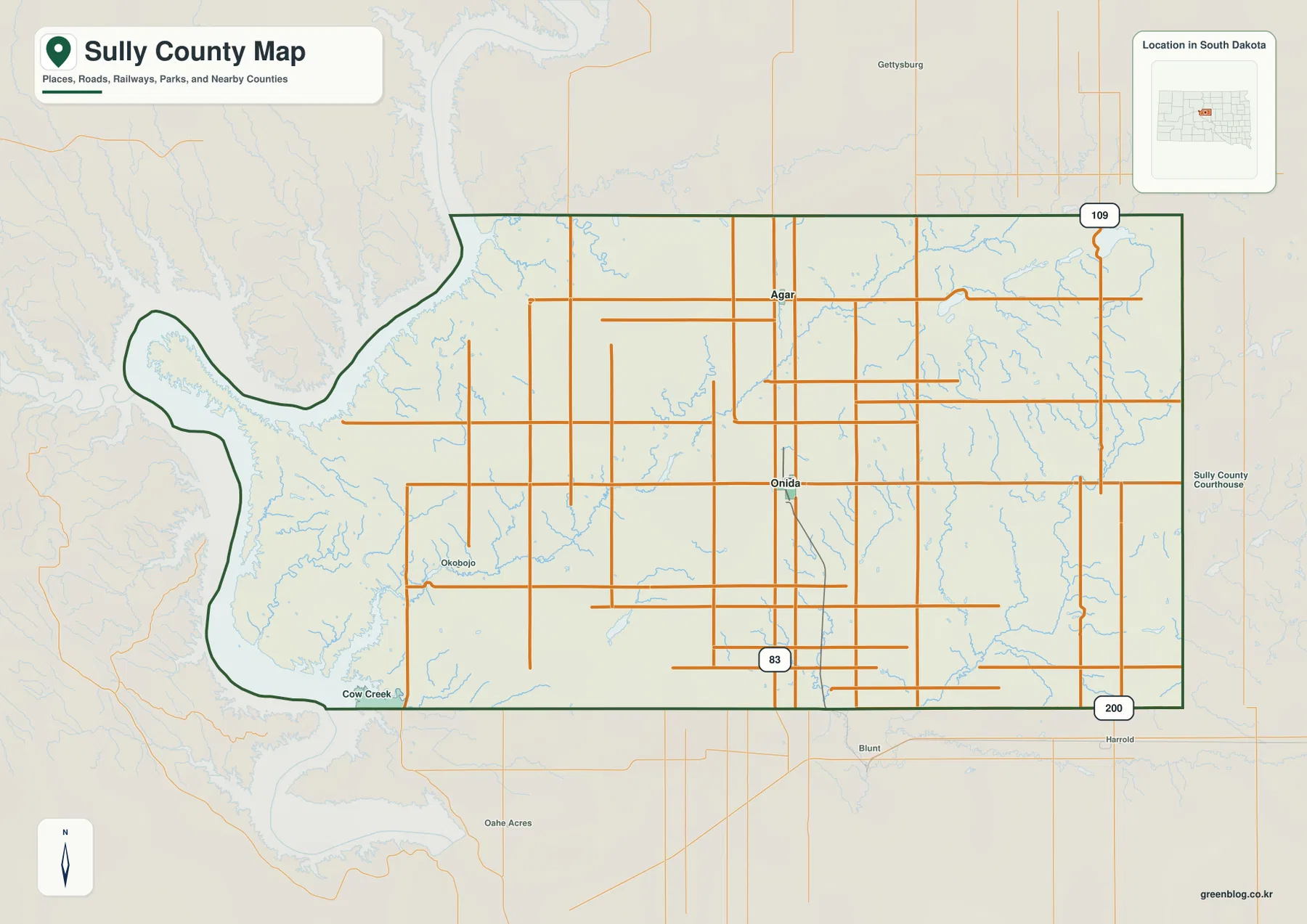
Onida is the most useful starting point on the general county map because it sits a little south of the county center and serves as the county seat. Agar appears farther north. US 83 runs through the same central part of the county, giving the map a clear north–south reference even though many local roads follow an east–west and north–south grid. The pattern is sparse in terms of named settlements but not in terms of roads: long rural routes spread across the interior and connect back toward the two communities and the larger highway corridor.
The western side breaks that grid-like appearance. Instead of a straight county line, the boundary bends around long reservoir arms, points, and creek mouths. Okobojo is labeled near the western interior, and Cow Creek appears near the southwest. The large water body outside the boundary is Lake Oahe, the reservoir on the Missouri River. Its shoreline pushes deeply into the western side of the county, producing a shape that is immediately different from the relatively straight line against Potter County to the north, Hyde County to the east, and Hughes County to the south.
The surrounding counties shown on the map help orient the less obvious western corners. Dewey County lies to the northwest across the Lake Oahe side, while Stanley County touches the southwest. Potter is north, Hyde is east, and Hughes is south. This is useful when comparing county maps because Sully County is not simply a rectangle between neighboring counties; part of its identity comes from the reservoir boundary and the way the western land projects toward the water. A cropped map that removed the shoreline would lose one of the county’s most recognizable geographic features.
For road orientation, the general map is more useful than the ranked city view because it keeps the broader network visible around Onida and Agar. It should still be treated as a reference map rather than a turn-by-turn navigation product. Seasonal road conditions, closures, construction, or route changes need current South Dakota Department of Transportation information. The same caution applies to boundaries: the county outline is appropriate for general geographic reference, but parcel ownership and legal land questions require current county GIS and recorded property information.
The ranked city view reduces a large county to two clear markers
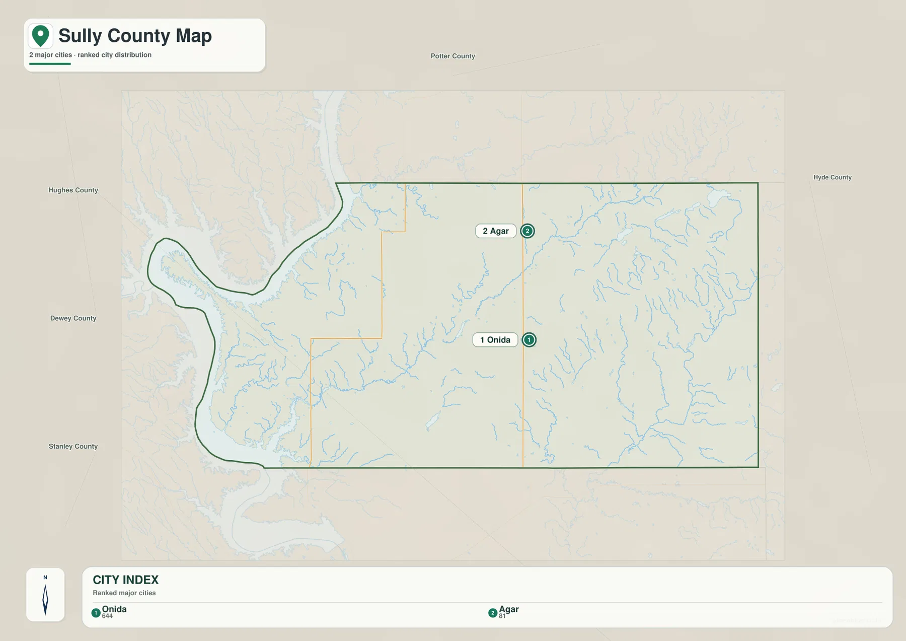
The city map intentionally removes much of the detail found on the general map. Only Onida and Agar receive numbered markers. The index at the bottom shows Onida first with a value of 644 and Agar second with a value of 81. Those figures are best read as the values used by this specific ranking layer, not automatically as current population estimates. The map’s job is to make relative position and ranking easy to see without asking the reader to sort through every road and water feature at the same time.
Onida is south of the county midpoint, while Agar sits north of it. They are not pushed toward opposite eastern and western edges; instead, both fall within the central interior. That arrangement is important because the county’s largest visual feature, Lake Oahe, occupies the west, yet the two selected community markers remain inland. The official county website also identifies Onida and Agar as Sully County’s two communities and names Onida as the county seat, so the simplified city layer is consistent with the county’s own basic description.
A map with only two markers can look empty, but that emptiness should not be interpreted as missing geography. The western shoreline contains named recreation and creek areas, and the general map carries a much larger set of rural roads. The ranked city view is simply a narrower tool. It works well when a slide, worksheet, or printed comparison needs to answer a direct question such as “Where are Onida and Agar relative to each other?” For countywide transportation, drainage, or terrain, another provided map gives a better answer.
Creeks from the interior reach Lake Oahe, while small lakes dot the east
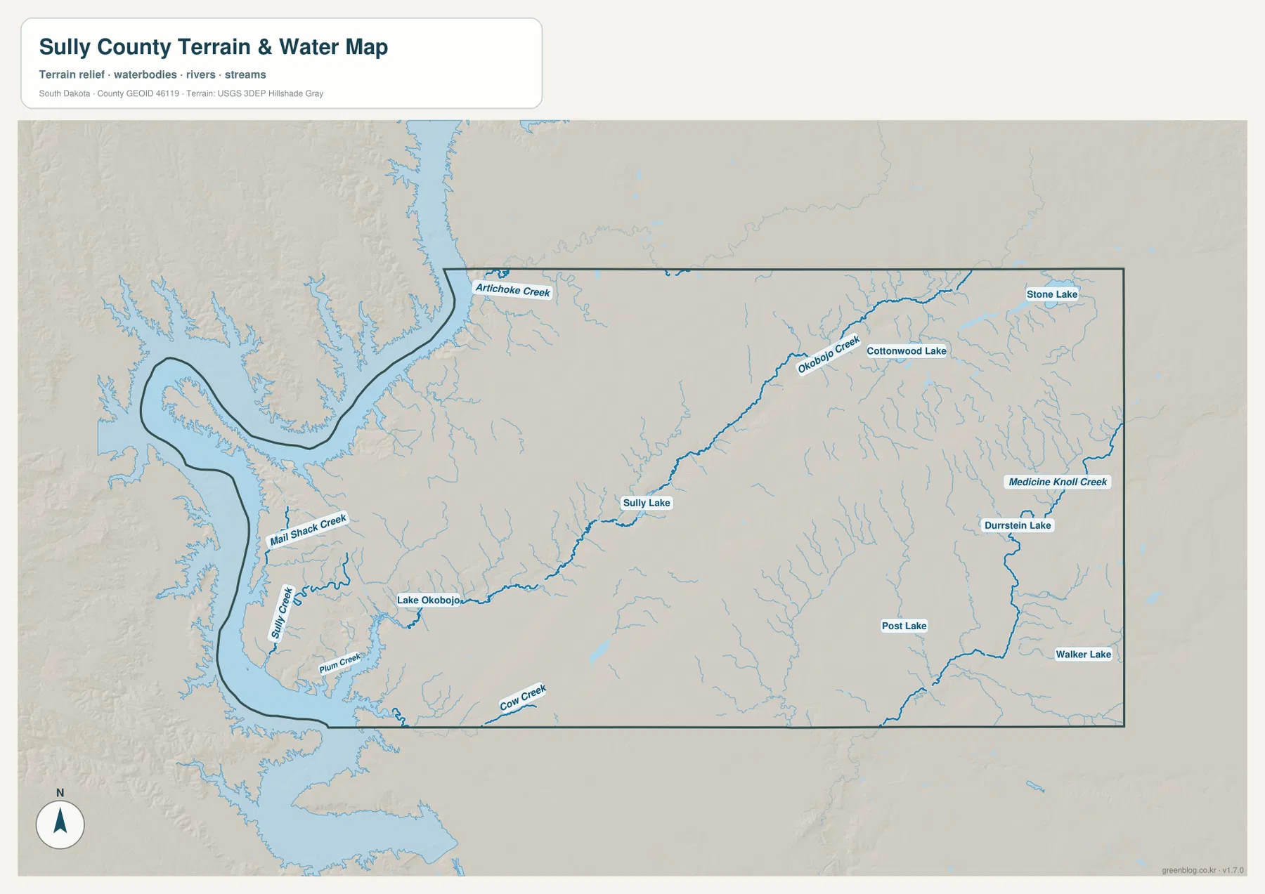
Water is the feature that most clearly separates the western side from the rest of Sully County. Lake Oahe forms the broad reservoir margin, and several named creeks approach it from short valleys. Artichoke Creek is labeled near the northwest, while Mail Shack Creek, Sully Creek, Plum Creek, and Cow Creek appear farther south. South Dakota Game, Fish and Parks describes nearby Okobojo Point as a recreation area on Lake Oahe, confirming the identity of the reservoir that dominates this side of the map. The many inlets explain why the county boundary becomes so irregular near the water.
Farther inland, the water pattern becomes more linear. Lake Okobojo appears in the west-central interior, and a prominent drainage continues northeast through the Okobojo Creek system. Sully Lake is labeled along this broad route, with Cottonwood Lake farther toward the northeast. Stone Lake is close to the far northeastern edge. These features are much smaller than Lake Oahe, but together they show that the county interior is not devoid of surface water. Small lakes and creek valleys break up the prairie across a wide area.
The eastern and southeastern portion has another recognizable network. Medicine Knoll Creek runs through the east and bends southward, with Durrstein Lake, Post Lake, and Walker Lake shown nearby. Numerous finer tributaries branch across the surrounding terrain. The contrast is useful: western creeks are visually tied to the large reservoir, while the east shows a wider web of small drainage lines and isolated lakes. Comparing those two sides helps explain why the terrain map contains much more detail than the simple city layer.
This map does not show flood probability, legal access, water depth, current streamflow, water quality, navigation hazards, or fishing regulations. A blue line confirms the mapped location of a water feature, not whether it is safe, navigable, flowing at a particular time, or open to the public. Anyone planning activity around Lake Oahe or a named creek should use current USGS, South Dakota, and local information for the specific decision. The map is most appropriate for geographic orientation and for understanding how named water features relate to the county boundary and terrain.
Low reservoir margins give way to higher northern and northeastern ridges
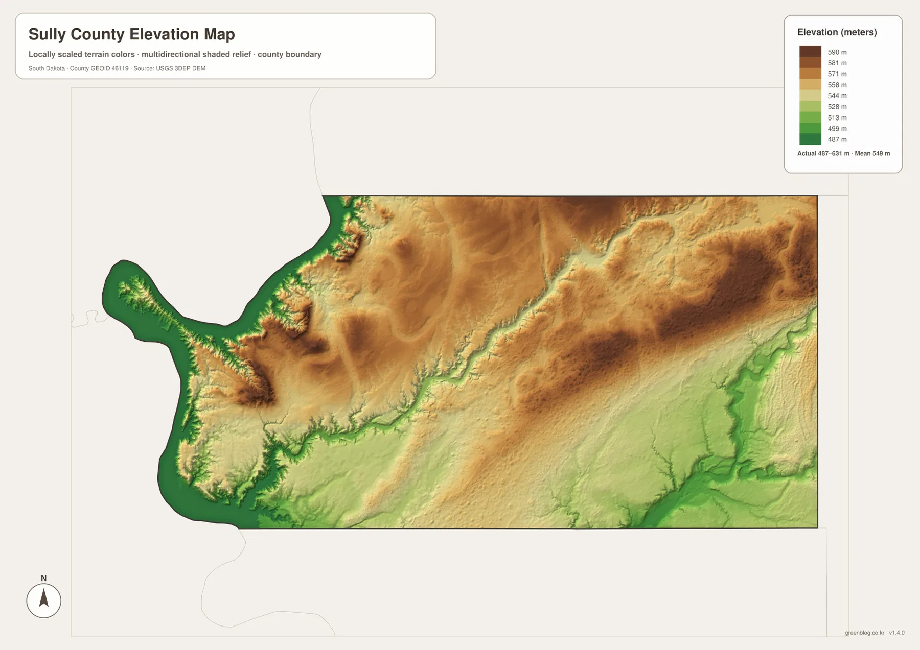
The elevation legend spans about 487 to 631 meters, with a mapped mean near 549 meters. Green tones line much of the Lake Oahe side, marking the lowest elevations on the surface. The low colors follow reservoir inlets and creek valleys before the land rises inland. This makes the western boundary easier to interpret: the water map shows where the creeks reach the reservoir, while the elevation view shows the lower valleys that carry those drainage paths toward the shore.
Higher terrain occupies broad parts of the north and northeast. Orange and brown colors spread across the north-central interior, and a pronounced higher area appears near the northeastern side. Smaller steep rises also occur close to the western reservoir where the land climbs quickly above incised creek valleys and bays. Sully County therefore does not read as one flat plane on the elevation surface. The broad prairie is interrupted by rolling high ground and sharper local relief near parts of the Lake Oahe margin.
The southeast introduces another change. Green valleys extend through a lower drainage area, roughly corresponding with the denser water network visible around Medicine Knoll Creek and its tributaries. The central Okobojo Creek corridor also follows lower ground through parts of the county. Viewing the water and elevation maps together is especially helpful here because the relationship is easier to see than it would be from either legend alone: named streams generally occupy lower routes between the higher interior surfaces.
The elevation image is a generalized reference surface based on USGS 3D Elevation Program data. Its colors and legend are suitable for comparing broad differences across the county, but the map is not survey-grade or engineering-grade. It should not be used to set a building elevation, calculate a precise road slope, establish drainage design, or resolve a property dispute. Site-specific work requires the original elevation data and, where appropriate, professional field measurements.
Choose the file according to the question, not simply by the amount of detail
For a first look at Sully County, the general map is the strongest choice because it puts Onida, Agar, US 83, the road grid, streams, and the western boundary into one frame. If the only purpose is to compare the two selected communities, the ranked city map is cleaner and faster to read. A presentation about county government can use Onida as a clear location reference, while a regional comparison can keep Agar visible to show how settlement extends north of the county seat.
For physical geography, the terrain-and-water and elevation maps work better as a pair. The water layer names the creeks and lakes; the elevation layer explains the broad rise from low reservoir margins toward higher northern and northeastern ground. Lake Okobojo, Sully Lake, Okobojo Creek, Medicine Knoll Creek, and the eastern lakes provide concrete reference points when comparing the two. This county-specific detail is more informative than treating the page as a generic collection of printable maps.
The WebP images in the article are sized for fast on-page viewing. The downloadable archive contains the corresponding original JPG files at 3638×2572 pixels each, which is more useful when small labels need to be enlarged or the map will be placed in a printed handout, presentation, classroom worksheet, or personal research document. The archive includes the general county map, ranked city map, terrain-and-water map, and elevation map. Keeping the originals together also makes it easier to compare the same county across different kinds of information without searching for separate files.
No single version should be treated as a substitute for purpose-specific official data. Legal boundary or property work needs current county and Census resources; travel decisions need current road information; water safety and access need current hydrologic and state guidance; and exact elevations need original USGS data or professional surveying. These maps are designed to answer the more basic but important geographic questions: where the communities sit, how the road network crosses the county, where water is concentrated, and how the land rises and falls from west to east and north to south.
Frequently Asked Questions
Why does the ranked city map show only Onida and Agar?
The ranked city layer is not intended to catalog every named place, rural address, road junction, or recreation area in Sully County. It highlights two selected community markers, with Onida ranked first and Agar second. The county government’s own overview also identifies Onida and Agar as the county’s two communities and names Onida as the county seat. Use the general map when you need the surrounding road network and additional geographic context rather than just the two ranked points.
Is the large western water body on the map Lake Oahe?
Yes. The western reservoir is Lake Oahe on the Missouri River. South Dakota Game, Fish and Parks identifies Okobojo Point in this area as a Lake Oahe recreation site. Several labeled creeks, including Artichoke Creek, Sully Creek, Plum Creek, and Cow Creek, approach the reservoir side of the county. The terrain-and-water map is suitable for locating these features, but current water levels, access conditions, and safety information must be checked separately.
Can the 487–631 meter elevation range be used for surveying or construction?
No. That range describes the elevation values used by the countywide reference surface. It is useful for seeing the low Lake Oahe margin and the higher northern and northeastern terrain, but it does not provide site-specific survey accuracy. Precise construction, drainage, or property work should use original USGS 3DEP data and appropriate professional measurements rather than values estimated from the colored map.
Map File Information
The archive contains the Sully County general map, ranked city map, terrain-and-water map, and elevation map as original high-resolution JPG files.
- Included Files: 4 high-resolution JPG maps
- Printable Size: 3638×2572 pixels each
- Intended Use: Printing, education, presentations, and geographic reference
Related Maps
Sources and References
- Sully County, South Dakota: official county overview covering location, Onida and Agar, county-seat status, 2020 population, and total area
- South Dakota Game, Fish and Parks – Okobojo Point Recreation Area: official Lake Oahe and Missouri River context for the western side of the county
- South Dakota Department of Transportation – CADD Mapping: official county-level road and water map resources, including Sully County
- U.S. Census Bureau TIGER/Line Shapefiles: authoritative county-boundary and geographic reference data
- USGS National Hydrography: official reference for rivers, lakes, streams, and other hydrographic features
- USGS 3D Elevation Program: elevation-data reference for the county elevation surface
Green Map creates custom-edited map images using open geographic data sources such as geoBoundaries, Natural Earth, OpenStreetMap, and government open data.
These maps are edited visual materials, not raw data files, and are provided for education, documents, presentations, and graphic reference.