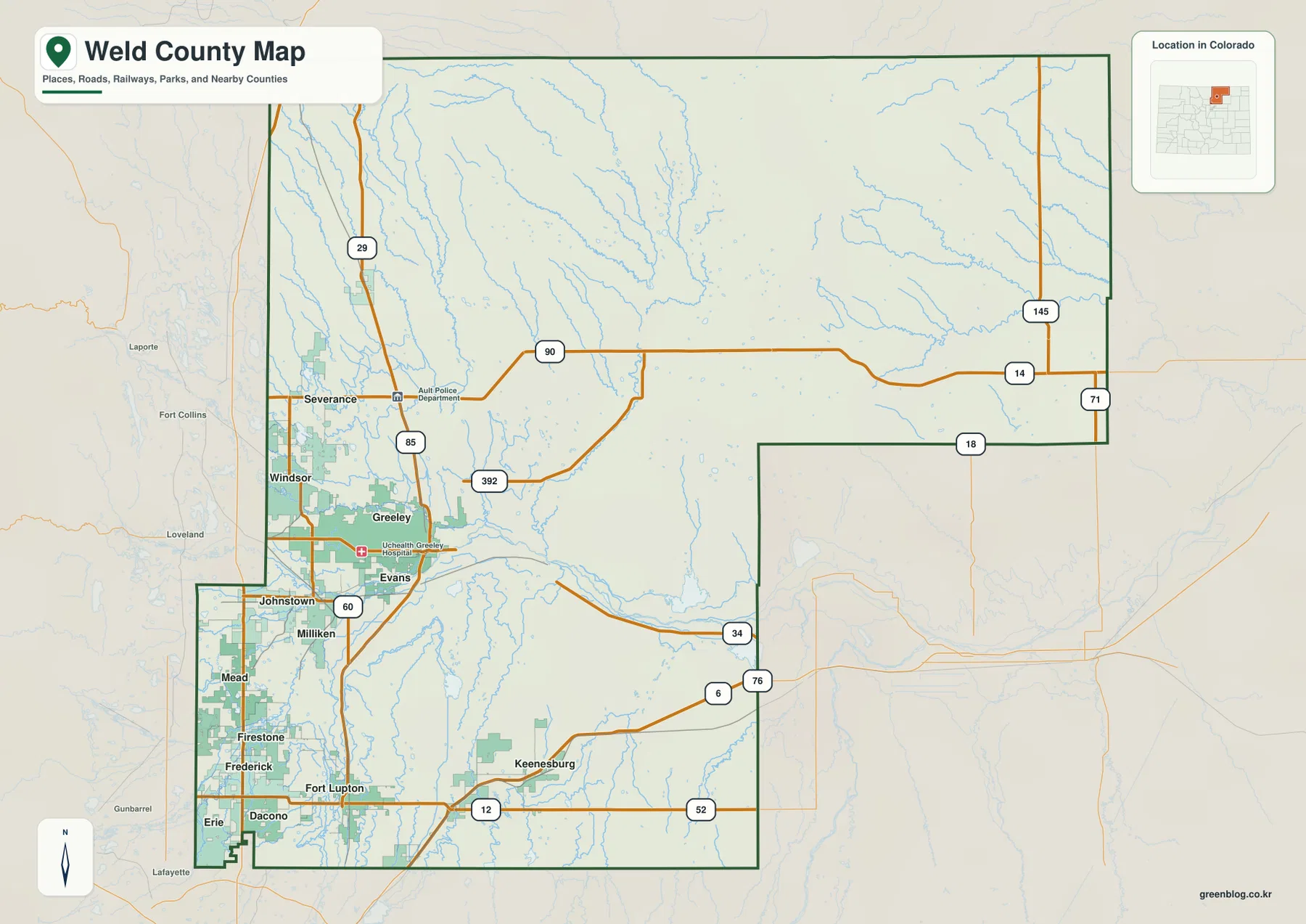
Download the high-resolution JPG originals for this Weld County Map in the ZIP below. The page covers Greeley, Windsor, Evans, and the dense group of southwestern communities, along with major roads, the Poudre and South Platte river systems, reservoirs, and an elevation range that falls from higher northwestern ground toward broad central and eastern plains. WebP versions are provided for quick browsing, while the full-size JPG files are better for printing, close inspection, and offline reference.
Weld County combines two very different settlement patterns. Greeley, Windsor, and Evans form a strong urban cluster on the western side, and a second chain of communities extends south through Johnstown, Milliken, Mead, Firestone, Frederick, Dacono, and Erie. Much of the central and eastern county is far more open, with long highways, agricultural land, reservoirs, and branching prairie streams. Using Greeley as the first reference point makes the contrast much easier to read.
Table of Contents
Greeley, Windsor, Evans, and the southwest urban corridor
Greeley is the most prominent place on the county map and sits near the junction of several important roads. U.S. 85 runs north-south through the western side of the county, while U.S. 34 extends east from Greeley into open plains. Windsor and Severance sit to the northwest and north, connected by Colorado 392 and other local routes. Evans is immediately south of Greeley, creating a closely linked urban area along the river and highway corridors.
The settlement pattern becomes even denser farther southwest. Johnstown, Milliken, Mead, Firestone, Frederick, Dacono, Erie, and Fort Lupton appear in a relatively compact area near major north-south and east-west roads. East of Keenesburg, town labels become much less frequent and long routes such as U.S. 34 and Colorado 14, 71, and 145 cross a much broader rural landscape. The county map therefore shows a clear transition from the Front Range urban edge to northeastern Colorado’s agricultural plains.
Weld County’s official history of incorporated towns explains that Greeley developed as the Union Colony between the Cache la Poudre and South Platte rivers, where irrigation supported agricultural settlement. That history helps explain the modern map: Greeley remains a major road and population center in the same water-rich western part of the county. The county map is intended for general location and road reference, not parcel boundaries or legal right-of-way work.
Six ranked cities concentrated on the western side
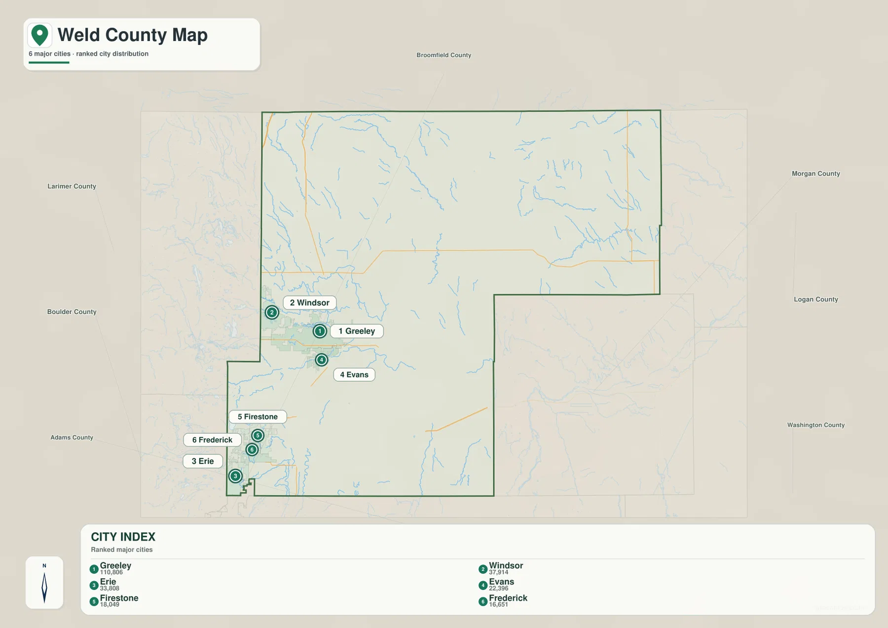
The city layer is a ranked distribution map rather than a connector-distance map. Its CITY INDEX lists Greeley first, Windsor second, Erie third, Evans fourth, Firestone fifth, and Frederick sixth. No straight-line mileage or driving distance is drawn between the cities, so the map is best used to compare rank and geographic concentration rather than travel distance.
The distribution is striking. Greeley and Evans occupy the west-central part of the county, Windsor sits northwest of them, and Erie, Firestone, and Frederick cluster close to the southwestern boundary. The eastern half of Weld County contains none of the six ranked city markers, even though the county extends far across the plains. That difference shows how a very large county can contain both one of northern Colorado’s strongest urban areas and extensive rural territory.
Labels for Larimer, Boulder, Broomfield, Adams, Morgan, Logan, and Washington counties provide regional context. Weld County reaches from the edge of the Front Range urban corridor toward the much more sparsely settled plains to the east. The ranked city layer makes this geographic transition visible without needing to add any mileage that is not present in the source map.
Poudre River, South Platte River, tributaries, and reservoir country
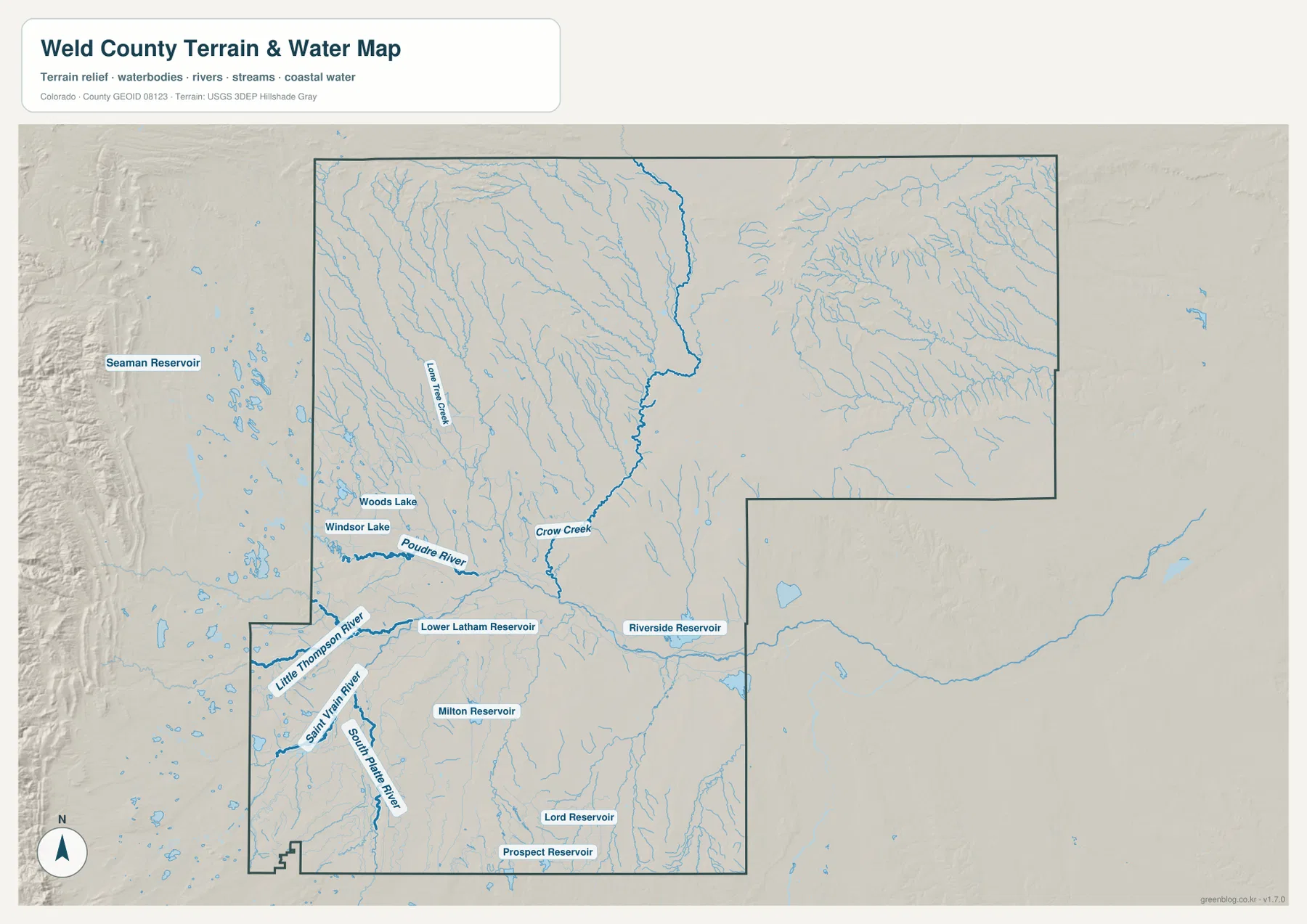
The Poudre River is the most important water reference in the western urban part of the terrain map. It passes through the Windsor–Greeley area and continues east across the plains. Woods Lake and Windsor Lake are labeled nearby, while numerous smaller drainage lines spread north and east from the western side. Weld County’s agricultural history describes how irrigation diversions from the Poudre River helped transform local farming, which matches the dense water network visible around the county’s western communities.
The South Platte River becomes another major reference in the southwest and southern part of the county. Saint Vrain River and Little Thompson River approach from the west, while Crow Creek crosses the central county and Lone Tree Creek appears farther northwest. Together these waterways show that Weld County is not organized around a single river valley. Several river systems and smaller prairie drainages overlap in the same county and help shape settlement and agriculture.
Reservoirs add another layer to the water map. Lower Latham Reservoir lies east of Greeley, Riverside Reservoir appears farther east, and Milton Reservoir is labeled in the central-southern area. Lord Reservoir and Prospect Reservoir sit still farther south. These water bodies are useful landmarks when reading the broad plains and agricultural areas between towns. The water layer is for general geographic reference and should not be used as a flood-hazard map, water-rights document, legal channel boundary, or navigation chart.
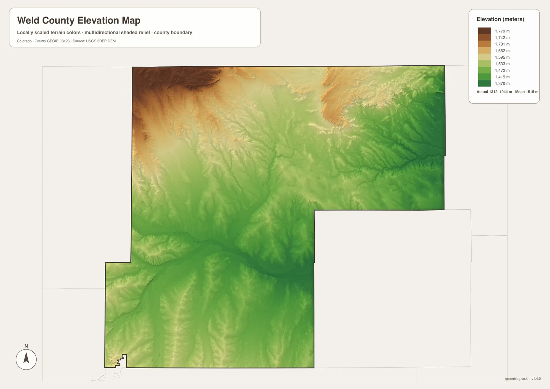
Elevation from about 1,312 to 1,944 meters
The elevation map reports an actual county range of about 1,312 to 1,944 meters, with a mean near 1,515 meters. Much of the central and eastern county is shown in lower green tones, matching the broad plains crossed by U.S. 34 and the major river systems. Greeley and Evans also sit in relatively low terrain compared with the county’s highest northwestern section.
Elevation rises most clearly toward the northwest, where broad tan and brown areas replace the greener plains. This is not steep alpine terrain, but the difference is substantial enough to change the drainage pattern: many small streams descend from higher western and northwestern ground toward the central and eastern county. North-central Weld County also shows a network of shallow valleys that adds more relief than a simple flat-plains description would suggest.
Comparing elevation and water explains why the Poudre and South Platte corridors occupy lower routes while smaller tributaries come down from higher ground. The same comparison also helps make sense of the county’s settlement geography, where the western side combines rivers, irrigation systems, major roads, and dense communities. This elevation layer is intended for countywide comparison, not site-specific surveying, construction, or engineering.
Greeley, irrigation, and the agricultural landscape
Weld County’s agricultural history connects local growth directly to water. County historical material describes the No. 3 Ditch from the Poudre River as an early irrigation system built specifically to grow food, and later farming expanded with water from the Poudre, St. Vrain, Big and Little Thompson, Boulder Creek, and the South Platte system. The modern water map still reflects that legacy through rivers, reservoirs, and dense drainage features around the western and central agricultural landscape.
This makes Greeley especially useful as a combined urban and agricultural reference point. The city map shows it as the county’s top-ranked city, the road map places it at major highway connections, and the water map shows important river and reservoir systems nearby. Reading those maps together gives a more complete picture than treating Weld County as only a suburban county or only an agricultural county.
Which map should you use first?
Start with the county map when you need Greeley, Windsor, Evans, the southwest communities, U.S. 85, U.S. 34, I-76, and the county boundary in one view. The ranked city map is best for comparing the six major cities, but it does not provide mileage. Use the water and terrain layer for the Poudre and South Platte rivers, tributaries, lakes, and reservoirs. Choose the elevation map when you want to compare the lower plains with higher northwestern terrain.
For example, to understand the Greeley–Windsor–Evans urban area, compare the county and city maps first. Add the water layer to see how closely the Poudre and South Platte systems relate to this western settlement zone. If you want to understand why the eastern half looks much more open and rural, the elevation and water maps show the broad plains and dispersed drainage network that continue far beyond the main cities.
Frequently Asked Questions
Does the city map show the distance between Greeley and Windsor?
No. The ranked city layer shows Greeley, Windsor, Erie, Evans, Firestone, and Frederick, but it does not include connector lines, straight-line mileage, or driving distance. Use it to compare city rank and location rather than travel distance.
Which map is best for the Poudre and South Platte rivers?
The water and terrain map is the best choice. It shows the Poudre and South Platte rivers, Saint Vrain and Little Thompson rivers, Crow Creek, Lone Tree Creek, and reservoirs including Lower Latham, Riverside, Milton, Lord, and Prospect.
Can the 1,312-to-1,944-meter elevation range be used for surveying?
No. The range is intended for broad geographic comparison between lower plains and higher northwestern terrain. Surveying, engineering, construction, or site-specific elevation work should use authoritative source data or professional survey measurements.
Map File Information
The ZIP contains the original high-resolution JPG versions of the county, ranked city, water/terrain, and elevation maps shown on this page. Use the larger files for printing, detailed viewing, or offline reference.
- Included Files: Use only the versions confirmed in the article and supplied images
- File Type: Use the confirmed download contents
- Intended Use: Printing, education, presentations, and map-based projects
Related Maps
Sources and references
- Weld County History – Incorporated Towns – Greeley, surrounding communities, and county-seat history
- Weld County History – Agriculture – irrigation, Poudre River water, and agricultural development
- Weld County official history – county formation and regional history
- U.S. Census Bureau TIGER/Line Shapefiles – county boundaries, roads, and place reference
- USGS National Hydrography – rivers, streams, lakes, and reservoirs
- USGS 3D Elevation Program – elevation and terrain reference
Green Map creates custom-edited map images using open geographic data sources such as geoBoundaries, Natural Earth, OpenStreetMap, and government open data.
These maps are edited visual materials, not raw data files, and are provided for education, documents, presentations, and graphic reference.