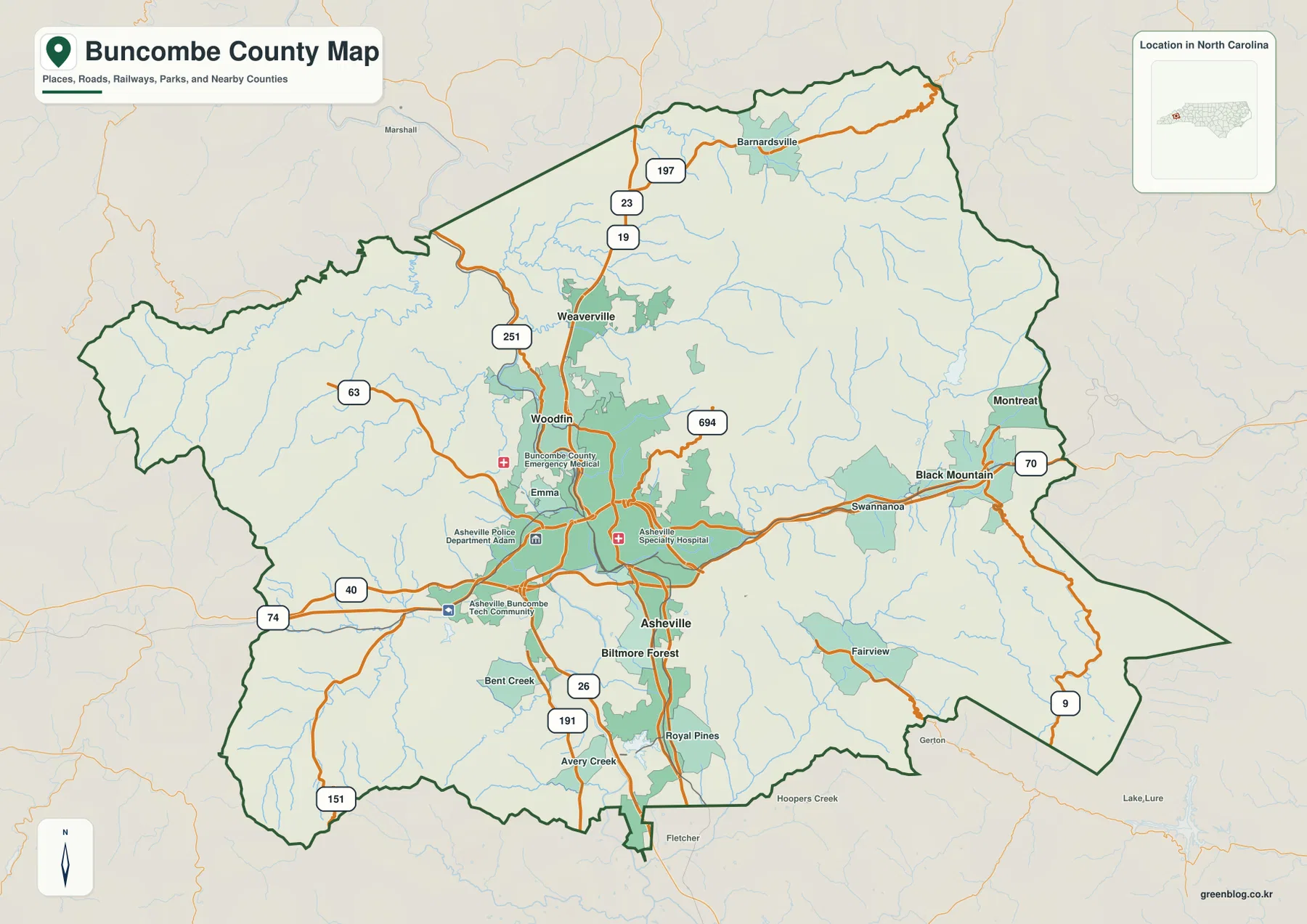
Buncombe County is easier to understand when the Asheville urban area is read together with the mountains and rivers around it. The county map shows a dense road network around Asheville, but that concentration quickly gives way to more widely spaced communities and rugged terrain toward the outer boundary. The French Broad River runs through the central part of the county, while the Swannanoa River approaches from the east. This page explains those relationships with the supplied county, city, and terrain-and-water maps, and the matching A3 high-resolution JPG map files can be downloaded as one ZIP archive.
Asheville is the strongest settlement reference on the maps, yet it is not the only useful point of orientation. Woodfin and Weaverville extend the settlement pattern northward, Black Mountain and Montreat sit well to the east in a different mountain setting, and Biltmore Forest lies close to Asheville on the south side. Major roads such as I-40 and I-26 meet the Asheville area and then continue toward different parts of western North Carolina. Reading the roads together with the river valleys makes the county’s layout much clearer than treating every place name as if it occupied the same kind of terrain.
The three maps serve different questions without turning the page into a technical GIS report. The boundary-and-road map is best for locating communities and routes, the city map simplifies the distribution of six major places, and the terrain-and-water map shows the mountain relief, rivers, creeks, reservoirs, and lakes that shape the physical setting. The download box near the end of the article provides the corresponding JPG files for printing or closer inspection.
Table of Contents
Asheville sits where the county road network becomes most concentrated
On the county map, Asheville occupies the south-central part of Buncombe County and is surrounded by the densest cluster of roads and mapped urban areas. I-40 crosses the county from west to east through the Asheville area, while I-26 provides a major north-south connection. Other labeled routes, including US 70, NC 191, NC 251, NC 9, NC 63, NC 151, and NC 197, spread into different valleys and outer parts of the county. This creates a clear contrast between the road-rich Asheville basin and the more widely spaced network toward the mountain edges.
Immediately north of Asheville, Woodfin appears along the central corridor, and Weaverville is farther north. The two places help show that the built-up area does not stop abruptly at the Asheville label. At the same time, they are not simply one continuous block on the map. Mountain ridges, river valleys, and changes in road spacing separate the communities, especially as the map moves toward Barnardsville and the northern boundary. The result is a northward sequence of settlements rather than a flat metropolitan grid.
East of Asheville, the map follows a different pattern. Swannanoa sits along the route toward Black Mountain, and Black Mountain is close to the eastern edge of the county. Montreat lies north of Black Mountain in the mountain terrain rather than along the main east-west route. Fairview is southeast of Asheville, while Biltmore Forest, Royal Pines, and Avery Creek occupy the southern side of the broader Asheville area. These placements make it useful to think of Buncombe County as several valley-based settlement groups connected by mountain roads, not as one evenly developed surface.
Six mapped communities reveal a strong center and separate eastern and northern nodes
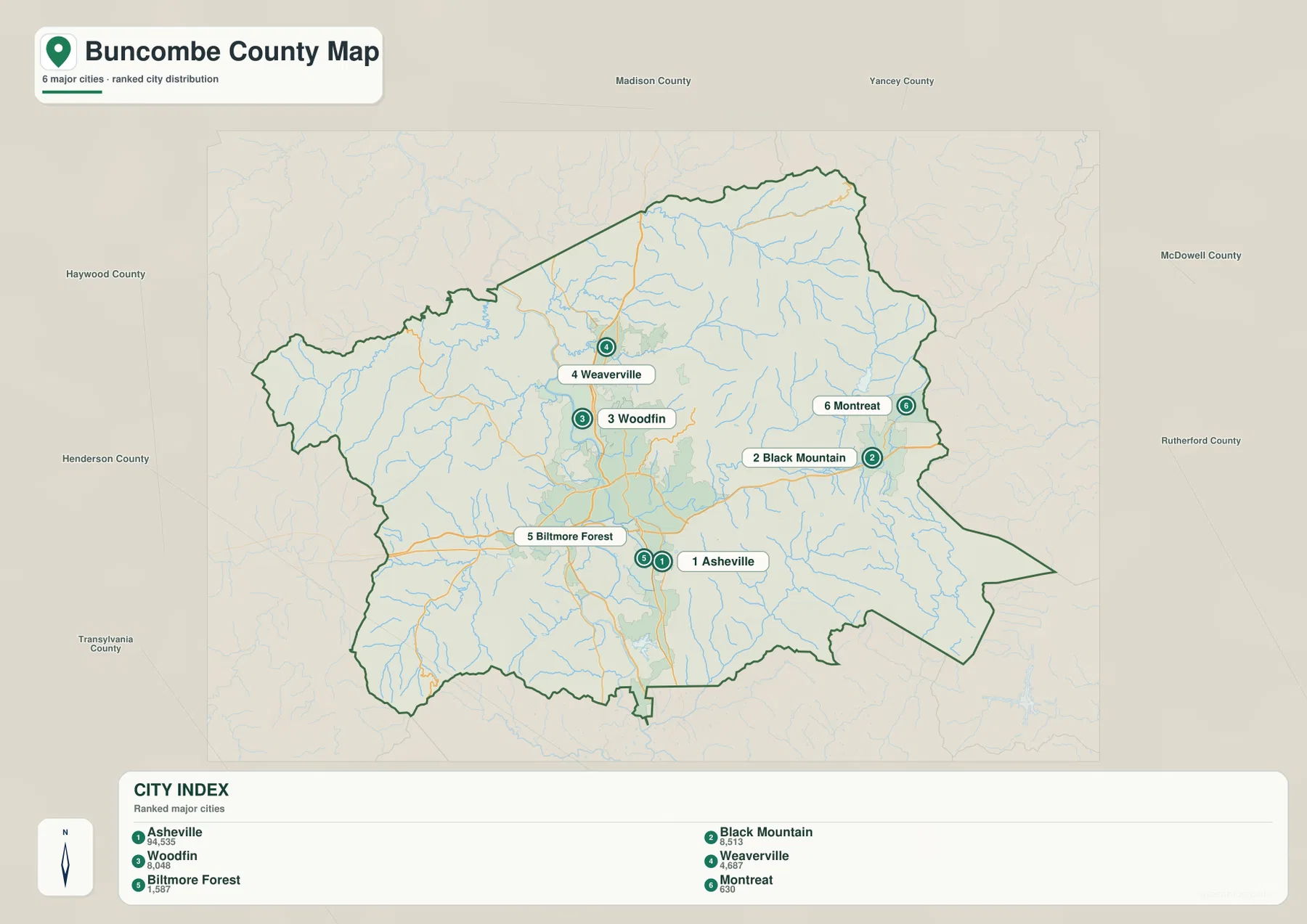
The city map removes much of the road detail and emphasizes six ranked communities: Asheville, Black Mountain, Woodfin, Weaverville, Biltmore Forest, and Montreat. Asheville is clearly the dominant center in the south-central portion of the county. Woodfin and Weaverville form a northward sequence, while Black Mountain and Montreat create a separate eastern grouping. Biltmore Forest lies close to Asheville, so it reads as a smaller community within the southern urban area rather than as an isolated outer settlement.
The supplied city index lists Asheville at 94,535, Black Mountain at 8,513, Woodfin at 8,048, Weaverville at 4,687, Biltmore Forest at 1,587, and Montreat at 630. These values are most useful here as the rankings printed on the provided map rather than as a claim about a separate current census release. The important geographic lesson is the imbalance in settlement size and location: one large center is accompanied by several much smaller places positioned along different mountain corridors.
The surrounding county labels also help with orientation. Madison and Yancey counties are shown to the north, McDowell and Rutherford to the east, Henderson and Transylvania to the south, and Haywood to the west. From Asheville, moving toward Black Mountain brings the reader closer to the eastern side of Buncombe County. Moving through Woodfin and Weaverville leads toward the northern boundary. Looking south from Asheville toward Biltmore Forest and Avery Creek brings the map closer to the Henderson County side. These simple relationships make the city map useful even without street-level detail.
The French Broad and Swannanoa rivers explain why Asheville occupies this particular basin
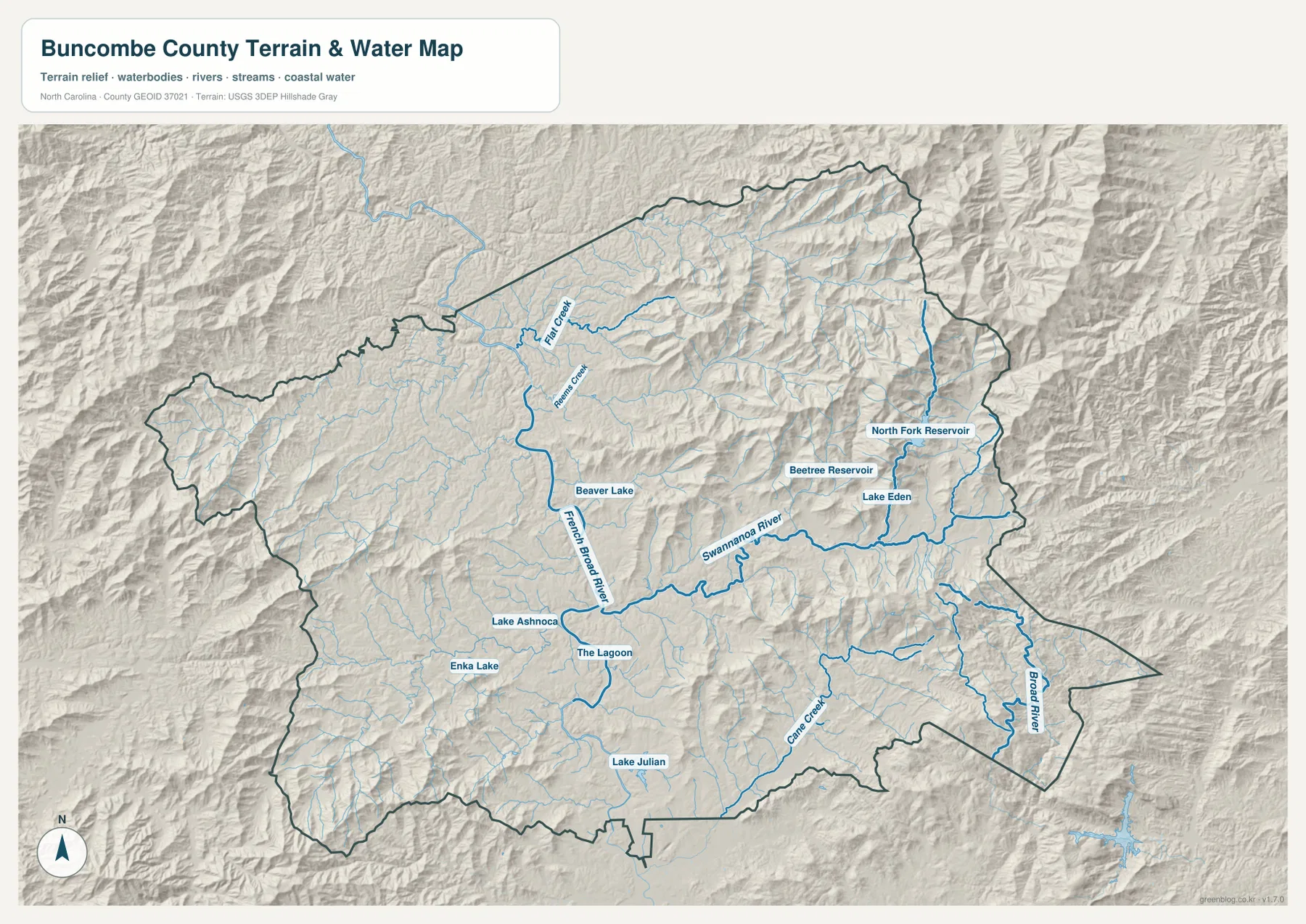
The terrain-and-water map changes the emphasis from roads to landform. Mountain ridges fill most of the county, with lower valleys cutting between them. The French Broad River is the most prominent central water feature, running through the county in a generally north-south direction. The Swannanoa River approaches from the east through the Black Mountain and Swannanoa side of the county before joining the French Broad near Asheville. Their meeting point gives the Asheville area a physical explanation that is not visible from road labels alone: the city sits where major valleys and waterways come together inside the surrounding mountains.
North of Asheville, Reems Creek and Flat Creek are labeled among the smaller waterways. The North Fork Reservoir and Beetree Reservoir appear in the northeastern mountain valleys, and Lake Eden is shown near the eastern side of the Swannanoa drainage. Beaver Lake is much closer to the central urban area. Together these features show that the county’s water pattern is not a single river with empty land around it. Numerous smaller tributaries descend from the ridges and feed larger streams, while reservoirs and lakes occupy specific valleys and developed areas.
South and west of Asheville, the map labels Lake Julian, Enka Lake, Lake Ashnoca, and The Lagoon. Cane Creek runs through the southeastern mountain area, while the Broad River is labeled near the southeastern side of the county. The Broad River and the French Broad River should not be treated as the same feature simply because their names are similar. On the supplied map they occupy different parts of Buncombe County’s drainage landscape, with the French Broad tied directly to the Asheville basin and the Broad River appearing farther southeast.
The shaded terrain gives a useful visual sense of ridges and valleys, but it is not a survey-grade elevation product. Likewise, the water lines and reservoir labels are intended for geographic orientation, not for navigation, parcel decisions, or flood-risk determination. For those uses, an official flood map, navigation source, property record, or detailed elevation dataset is more appropriate. Here the value of the map is seeing how water and terrain fit around the communities named on the other two maps.
Black Mountain makes the eastern side look different from the quieter western mountains
Both sides of Buncombe County are mountainous, yet the maps show different settlement patterns. The eastern side has a clear chain of named places and routes: Asheville leads to Swannanoa, then to Black Mountain, with Montreat set just to the north. The terrain map adds Lake Eden, the North Fork Reservoir, the Beetree Reservoir, and the Swannanoa River to the same broad area. Because communities, roads, and water features all appear within a relatively compact eastern corridor, this side of the county is easy to describe through connected landmarks.
West of Asheville, roads such as NC 63 and NC 151 extend into a broader area where named settlements are less concentrated on the supplied maps. The terrain shading remains strong, but the visual emphasis shifts toward ridges, tributaries, and longer gaps between urban labels. This does not mean the west lacks communities or roads; it means the selected county maps show fewer major settlement labels there. For a reader using these particular maps, the useful comparison is therefore between a clearly marked eastern settlement corridor and a more sparsely labeled western mountain landscape.
From Weaverville to the southern county line, the central corridor changes character several times
The north-south view is just as important as the east-west one. Barnardsville is separated from the larger urban concentration near the northern end of the county. Farther south, Weaverville becomes a more substantial settlement reference, followed by Woodfin and then Asheville. The French Broad River runs through much of this central area, so it provides a natural feature that can be followed alongside the road network. The river should not be mistaken for an administrative boundary, but it is useful for keeping the northern communities oriented relative to Asheville.
South of Asheville, Biltmore Forest, Royal Pines, and Avery Creek continue the settlement pattern toward the county line. I-26 and NC 191 are among the roads that help connect this southern side, and Fletcher is labeled just outside the boundary. Lake Julian also appears in the southern part of the terrain-and-water map. When the three maps are compared together, the southern area reads as a continuation of the Asheville basin toward Henderson County, while the northern area becomes progressively more mountain-oriented as the distance from Asheville increases.
Choose the map according to the question you are trying to answer
For a first look at Buncombe County, the boundary-and-road map is the most practical starting point. It combines major communities, highways, secondary routes, county edges, and nearby place references. It is useful when the question is simply where Asheville, Weaverville, Black Mountain, Fairview, or another labeled place sits within the county. It also gives enough road context to understand which directions connect the Asheville area with the outer mountain communities.
The city map is better when the road network is distracting and the goal is to compare the six ranked communities. It makes the dominant size of Asheville immediately clear, while separating the northern Woodfin-Weaverville pattern from the eastern Black Mountain-Montreat pattern. For a classroom handout or a simple regional presentation, that reduced set of labels can be easier to explain than the full county map.
The terrain-and-water map is the right choice when the physical landscape is the main subject. It connects the French Broad and Swannanoa rivers with the surrounding ridges, creeks, reservoirs, and lakes, helping explain why roads and communities occupy particular valleys. Using all three maps in sequence works especially well: start with the county boundary and roads, simplify the settlement pattern with the city map, and then add the terrain-and-water map to explain the mountain setting beneath those places.
The WebP images in the article are intended for convenient on-page viewing. If you need to print, crop, enlarge, or place the maps into a document, use the downloadable JPG files instead. The archive contains the three supplied map types at high resolution so the road, city, and terrain-water views can be used separately without relying on a browser screenshot.
Frequently Asked Questions
Are Asheville and Black Mountain part of the same mapped urban area?
They are both important Buncombe County communities, but the supplied maps show them as distinct locations. Asheville occupies the main south-central road concentration, while Black Mountain sits much farther east near the county edge after the Swannanoa corridor. The city and county maps make that separation easier to see than a simple list of place names.
How can I tell the French Broad River from the Swannanoa River on the map?
The French Broad River is the larger central river running through the Asheville area in a generally north-south direction. The Swannanoa River comes from the east, passing through the Black Mountain and Swannanoa side before joining the French Broad near Asheville. Following those two directions is one of the clearest ways to understand the county’s central basin.
Can the terrain-and-water map be used for flood risk, navigation, or property boundaries?
No. It is a regional reference map for the relative positions of rivers, creeks, reservoirs, lakes, and mountain relief. Flood-risk decisions require an official flood map, navigation requires an appropriate navigation source, and property boundaries require parcel or deed records. The terrain shading should also not be treated as survey-grade elevation measurement.
Sources and Reference Data
The geographic description above is based first on the three supplied Buncombe County maps. The following official or county sources are useful for checking the type of boundary, hydrography, and elevation information represented in regional mapping.
- Buncombe County Community Health Assessment
- U.S. Census Bureau TIGER/Line Shapefiles
- USGS National Hydrography
- USGS 3D Elevation Program
Map File Information
Download the Buncombe County boundary-and-road map, major-city map, and terrain-and-water map as high-resolution A3 JPG files. The ZIP contains three JPG images corresponding to the maps shown on this page.
- Included Files: Use only the versions confirmed in the article and supplied images
- File Type: Use the confirmed download contents
- Intended Use: Printing, education, presentations, and map-based projects
Related Maps
Green Map creates custom-edited map images using open geographic data sources such as geoBoundaries, Natural Earth, OpenStreetMap, and government open data.
These maps are edited visual materials, not raw data files, and are provided for education, documents, presentations, and graphic reference.