St. Helena Parish in southeastern Louisiana is a rural parish where Greensburg provides the main road reference and a dense web of creeks covers nearly every part of the map. Montpelier lies to the southeast, Grangeville near the southwest side, and Easleyville farther north. LA 10, LA 43, and LA 441 organize the central road network, while the Tickfaw River system, Darlington Creek, Black Creek, and smaller tributaries provide a second set of geographic landmarks. This page explains those visible relationships, and the matching high-resolution JPG map files can be downloaded together in a ZIP.
Greensburg is the parish seat. The St. Helena Parish Police Jury’s history page explains that after the southern part of the parish became Livingston Parish in 1832, the courthouse was moved to the more centrally located Greensburg, where it remains. That history fits the supplied map well: Greensburg sits near the middle of the road network, with Montpelier to the southeast and the smaller communities and rural roads spread around it.
Table of Contents
Greensburg is the road center where LA 10, LA 43, and LA 441 come together
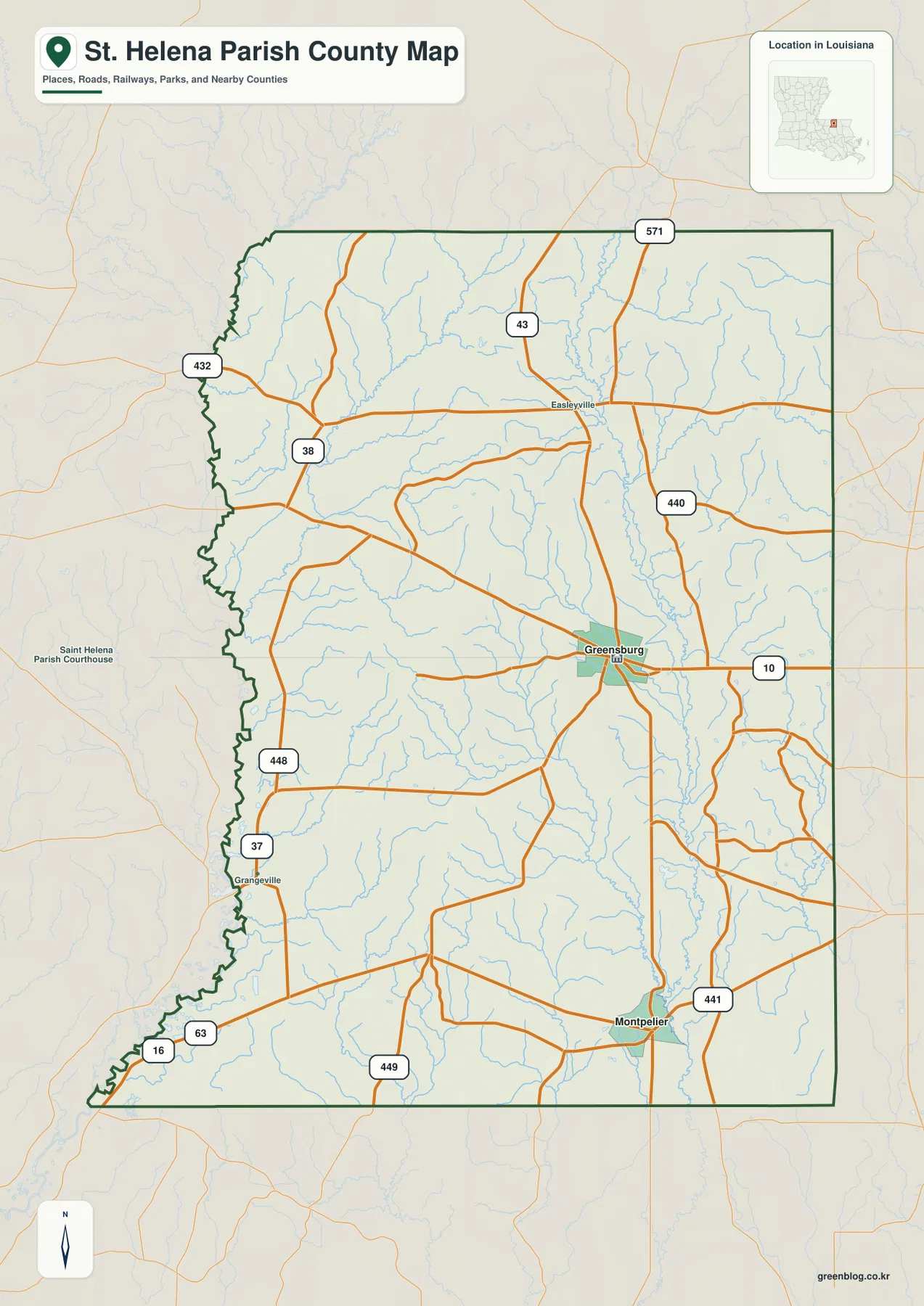
The general parish map places Greensburg a little south of the geographic center. LA 10 runs east-west through town, LA 43 approaches from the north, and LA 441 continues toward the southeastern side and Montpelier. These three routes create a simple first framework for the parish. Once they are located, the smaller state highways become much easier to fit into the map.
LA 38 and LA 432 appear in the northwest, while LA 571 is visible near the upper eastern side. South and southwest of Greensburg, LA 448 and LA 37 help locate the Grangeville area. Near the bottom of the parish, LA 63, LA 16, and LA 449 provide additional references. This is not an interstate-centered map; the settlement pattern depends on a network of state roads connecting small communities and rural land.
Montpelier and Grangeville provide opposite references across the southern parish
Montpelier sits in the southeastern portion of the parish near LA 441. Its position makes it a useful landmark for the lower eastern side, where the road network begins to approach the Tangipahoa Parish boundary. Montpelier also has historical significance: the parish history page notes that it was established as the permanent seat of justice in 1813 before the courthouse was later moved to Greensburg.
Grangeville lies near the southwestern side around LA 37 and LA 448. That side of the parish has fewer prominent settlement labels and more small roads and streams, so Grangeville works as a practical anchor for the lower western area. Using Montpelier and Grangeville as opposite southern references also makes Greensburg’s more central position easier to understand.
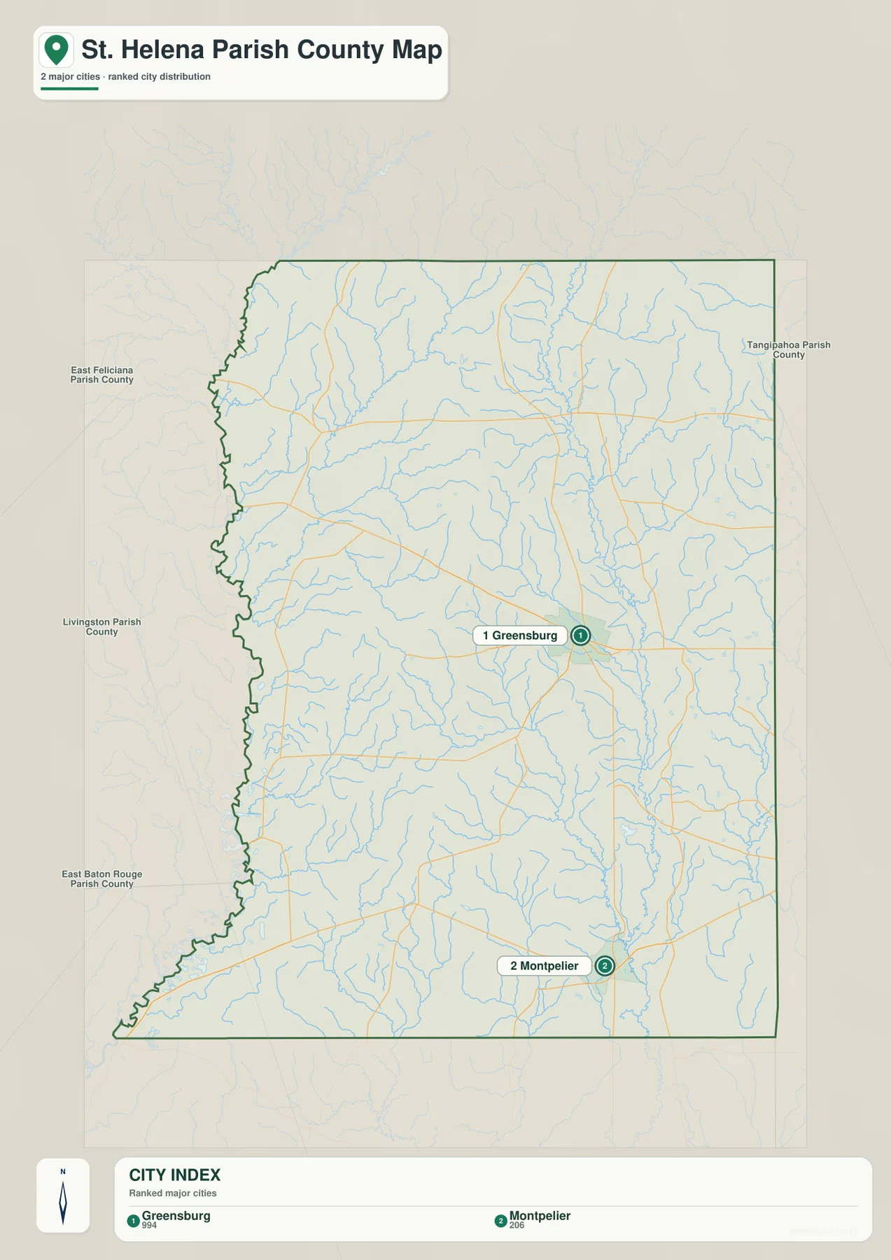
The city index ranks only Greensburg and Montpelier
The city-index graphic contains just two ranked places: Greensburg is number 1 and Montpelier is number 2. Those numbers are rankings, not straight-line or driving distances. The simplified map therefore focuses on the relative position of the two selected incorporated communities rather than trying to reproduce every small place label from the general road map.
Grangeville and Easleyville are visible on the detailed map but are not part of this two-place index. That difference is useful to keep in mind when switching between map types. Use the city index for a clean comparison of Greensburg and Montpelier, and use the general map when smaller communities, road numbers, and boundary detail matter.
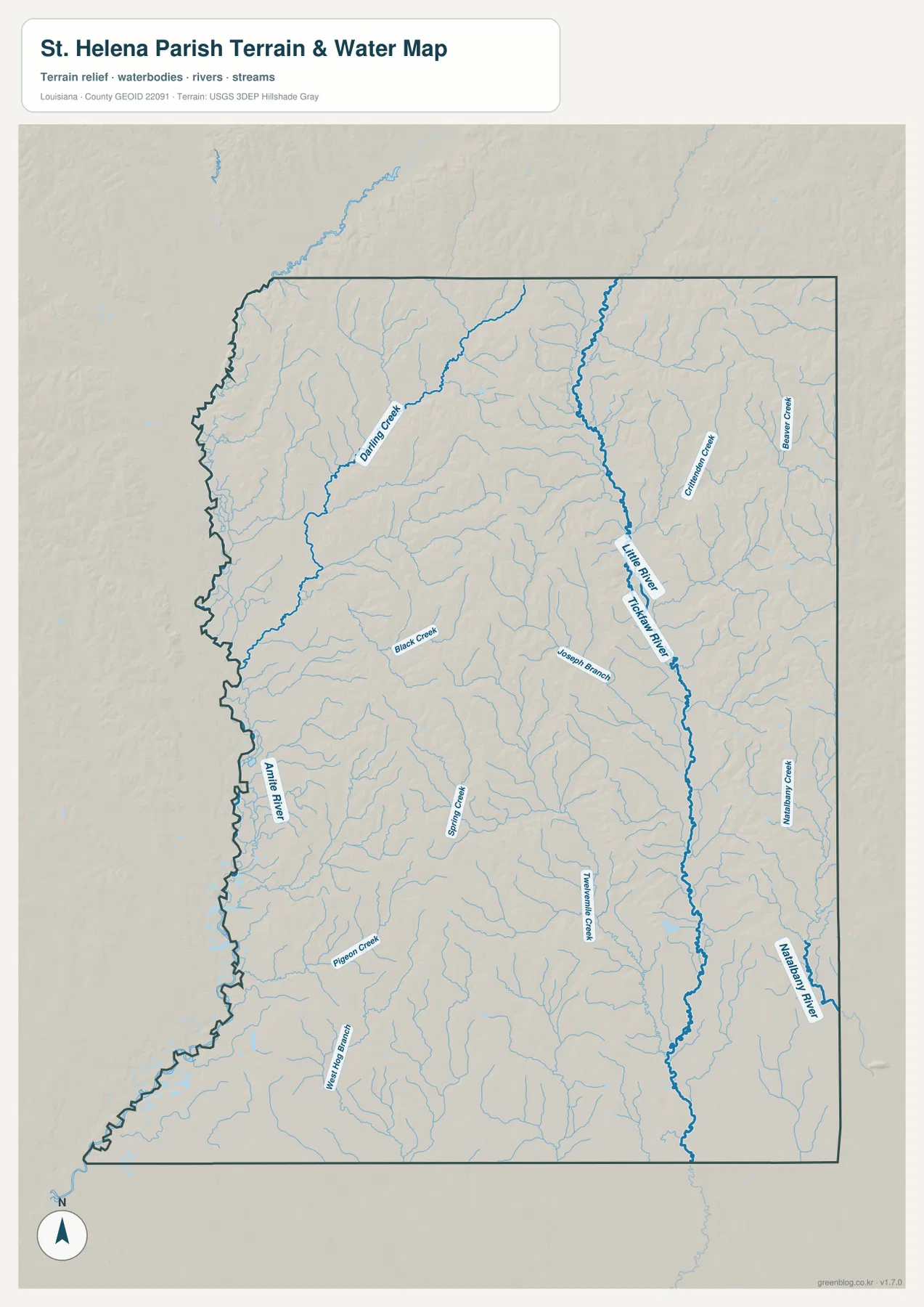
The Tickfaw River and Little River system dominates the eastern drainage
The terrain-and-water map gives the eastern half a very different appearance from the road map. A prominent Little River and Tickfaw River channel runs through the central-eastern side, collecting numerous smaller tributaries as it continues south. On the settlement map, Greensburg and LA 10 are the easiest landmarks; on the water map, this river system becomes the strongest reference for the eastern interior.
Germany Creek and Beaver Creek are labeled east of the main channel, while Natalbany River appears farther southeast. Joseph Branch and Madison Creek add smaller named streams closer to the middle. These waterways show that the eastern parish is not defined by one river alone. Instead, many short tributaries divide the rural landscape into small drainage areas.
Darlington Creek and Black Creek organize the western side
Darlington Creek is the strongest named water feature in the northwestern and western interior. It runs through a long section of the parish and gathers many thin tributaries. Black Creek lies farther south and closer to the middle, providing another useful reference between the west side and the Greensburg area. Together they create a drainage pattern that contrasts with the Tickfaw River system farther east.
The lower half adds Spring Creek, Pigeon Creek, West Hog Branch, and Tremont Creek. The Amite River is labeled near the western side, providing broader regional context along the neighboring-parish edge. These blue lines are meant for geographic orientation only; the map does not provide flood-zone classifications, water depth, navigability, levee status, or legal property boundaries.
Use Greensburg for roads and divide the creek systems east and west
A road-first approach begins with Greensburg. LA 10 establishes the east-west direction, while LA 43 and LA 441 provide the strongest north-south references. Add Montpelier to the southeast, Grangeville to the southwest, and Easleyville to the north. After that framework is in place, smaller routes such as LA 38, LA 432, LA 448, and LA 37 are easier to locate without crowding the mental picture.
For water features, split the parish between the Tickfaw River and Little River system in the east and Darlington Creek in the west. Black Creek helps with the middle, while Spring Creek and Pigeon Creek provide southern reference points. The general map is best for settlements and roads, the city index for Greensburg and Montpelier, and the terrain-and-water map for the parish’s dense stream network.
Original JPG files make small road and creek labels easier to inspect
The downloadable ZIP contains the original JPG files corresponding to the three previews on this page: the general parish map, the ranked city map, and the terrain-and-water map. Each original image is 2572 by 3638 pixels, providing more room to enlarge route numbers, place names, and small stream labels than the web preview. The files are useful for printing, classroom material, presentation slides, and personal geographic reference.
Choose the general map when Greensburg, the state-road network, and the parish boundary need to appear together. Use the city index for a quick comparison of Greensburg and Montpelier. The water map is the better choice for the Tickfaw River, Little River, Darlington Creek, Black Creek, and the many smaller tributaries. These are general reference maps rather than legal boundary, survey, flood-risk, or real-time navigation products.
Frequently Asked Questions
What is the parish seat of St. Helena Parish?
Greensburg is the parish seat and the clearest central road reference on the supplied map. LA 10, LA 43, and LA 441 meet around the area, while Montpelier lies to the southeast, Grangeville to the southwest, and Easleyville to the north.
Do the numbers 1 and 2 on the city map represent distance?
No. They are rankings for Greensburg and Montpelier. The city index does not show straight-line or driving mileage, so use the general road map and current navigation information when distance or travel time matters.
Can the Tickfaw River and creek map be used as a flood or navigation map?
No. It is a general geographic reference showing the Tickfaw River, Little River, Darlington Creek, Black Creek, and other streams. It does not provide flood-zone ratings, water depth, navigability, levee protection, or legal property boundaries. Those decisions require current specialized information.
Map File Information
The ZIP contains the original high-resolution JPG files corresponding to the general parish map, ranked city map, and terrain-and-water map shown on this page.
- Included Files: parish map JPG, ranked city map JPG, terrain-and-water map JPG
Related Maps
Sources and references
For local government and parish history, see the St. Helena Parish Police Jury and its History of St. Helena page. General boundary data are documented by the U.S. Census Bureau TIGER/Line Shapefiles, and national water-feature data are documented through USGS National Hydrography.
Green Map creates custom-edited map images using open geographic data sources such as geoBoundaries, Natural Earth, OpenStreetMap, and government open data. These maps are edited visual materials, not raw data files, and are provided for education, documents, presentations, and graphic reference.