Russell County sits in south-central Kentucky where two compact population centers, a north-south highway corridor, and the deeply indented waters of Lake Cumberland meet. This Russell County Kentucky Map set separates those features into a boundary-and-road map, a city map, a terrain-and-water map, and an elevation map. Together they show Russell Springs and Jamestown, U.S. 127 and the surrounding state routes, the Cumberland River drainage, and relief ranging from roughly 166 to 348 meters. The original high-resolution JPG files are also available in one ZIP for printing, classroom work, presentations, or detailed reference. High-resolution map files are available for download in the section below.
The county is easiest to understand by starting in the middle. Russell Springs lies north of Jamestown, and U.S. 127 forms a clear link between them. From that corridor, roads spread west toward the Adair County side and east toward the lake-cut country near Pulaski and Cumberland counties. The southern half looks very different from the northern uplands because Lake Cumberland sends long arms into the valleys. As a result, straight-line proximity can be misleading: water, ridges, and irregular shorelines often determine how places are actually connected.
Table of Contents
U.S. 127 anchors the Russell Springs–Jamestown corridor
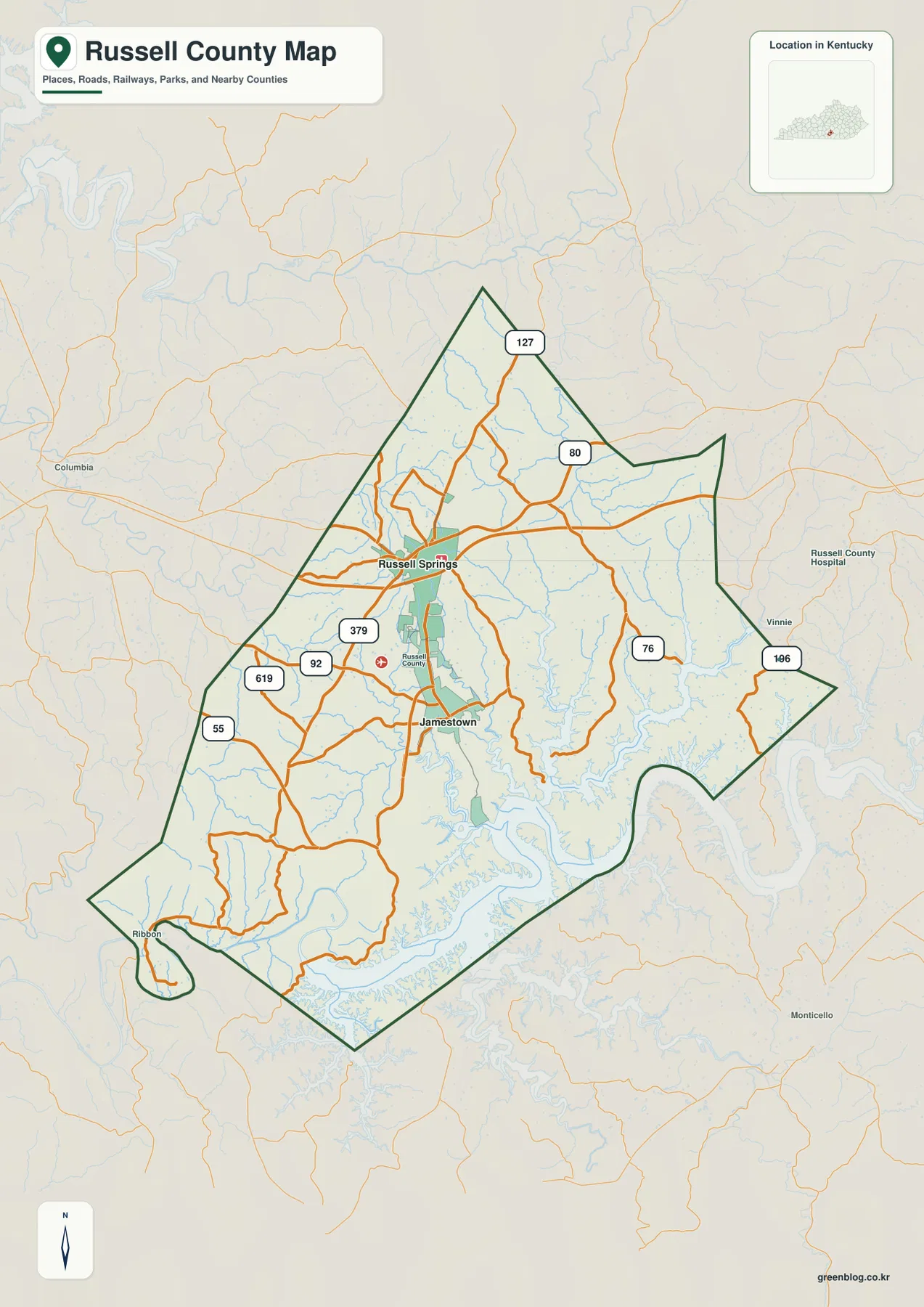
The general county map makes U.S. 127 the most obvious transportation reference. It enters from the north, passes through Russell Springs, continues south through Jamestown, and then heads toward the Lake Cumberland area. KY 80 crosses the Russell Springs vicinity from west to east, while KY 92, KY 55, and KY 619 serve the western and southwestern side. East of the central corridor, KY 76 and KY 106 wind through a more dissected landscape where lake arms and narrow valleys become increasingly important.
Russell Springs works well as the first orientation point for the northern and western parts of the county. Jamestown, the county seat according to the Russell County Fiscal Court, lies about six miles away and is positioned closer to the major lake shoreline. That short separation gives Russell County a compact central settlement pattern even though the county extends well beyond the two cities. On the map, local roads fan outward from this central pair into much more sparsely labeled upland and lake country.
The county outline is unusually irregular. The north narrows to a point, the east contains projecting sections, and the south is broken by deep inlets associated with Lake Cumberland. In several places, land that looks close across a bay is separated by a long water arm, so a direct visual comparison does not equal a practical driving route. This is one reason the boundary-and-road map is most useful when read together with the terrain and water layer rather than as a stand-alone road diagram.
Labels outside the boundary also help establish regional direction. Columbia appears to the west, Monticello lies southeast, and the outer map shows the approach toward nearby communities and counties. Those labels are not part of Russell County, but they provide useful anchors when following routes away from Russell Springs or Jamestown. The map is a static geographic reference, not a live navigation product, so current closures, construction, and travel times should be checked through up-to-date transportation services before driving.
A compact two-city pattern stands out inside a broad rural county
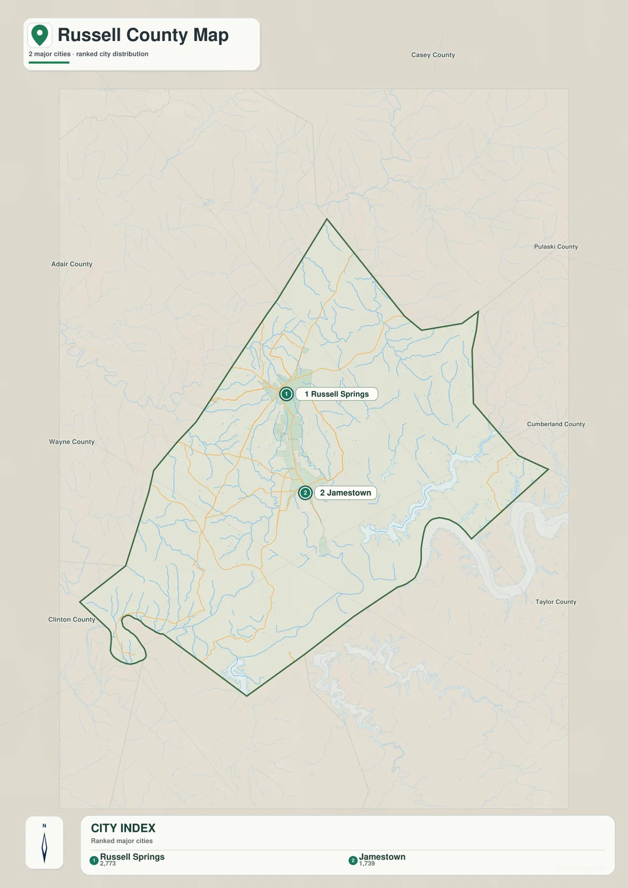
The city map strips away most route numbers and gives the two ranked centers much more visual weight. Russell Springs is marked first and Jamestown second, with index values of 2,773 and 1,739 shown in the footer. Those figures are best treated as values used by the map’s city-ranking layer rather than as a statement of current official population. The lasting geographic point is the placement: both communities occupy the central part of the county, with Russell Springs to the north and Jamestown to the south.
Their proximity contrasts with the large amount of countryside surrounding them. North and west of Russell Springs, the map opens into broad upland areas with only the drainage and road network providing structure. South of Jamestown, the pattern quickly changes as the Lake Cumberland shoreline becomes more prominent. That transition explains why the two cities function as convenient reference points even when a destination lies far out on a peninsula, along a creek valley, or near the county edge.
The surrounding county names make this simplified map particularly useful for orientation. Casey County is shown to the north, Pulaski to the northeast, Cumberland to the east, and Taylor farther southeast. Adair lies to the west, while Wayne and Clinton frame the southwestern side. These labels help a reader understand which direction a road or lake arm is leading without needing to keep every route number in view.
For a presentation focused only on settlement geography, this file is cleaner than the full county map. It answers where the two principal centers sit and how they relate to the county boundary. When the question changes from “where are the cities?” to “how are they connected?”, the general map supplies the needed route detail. Used together, the two files keep location and transportation from being mixed into one overly crowded graphic.
Lake Cumberland and the Cumberland River reshape the southern half
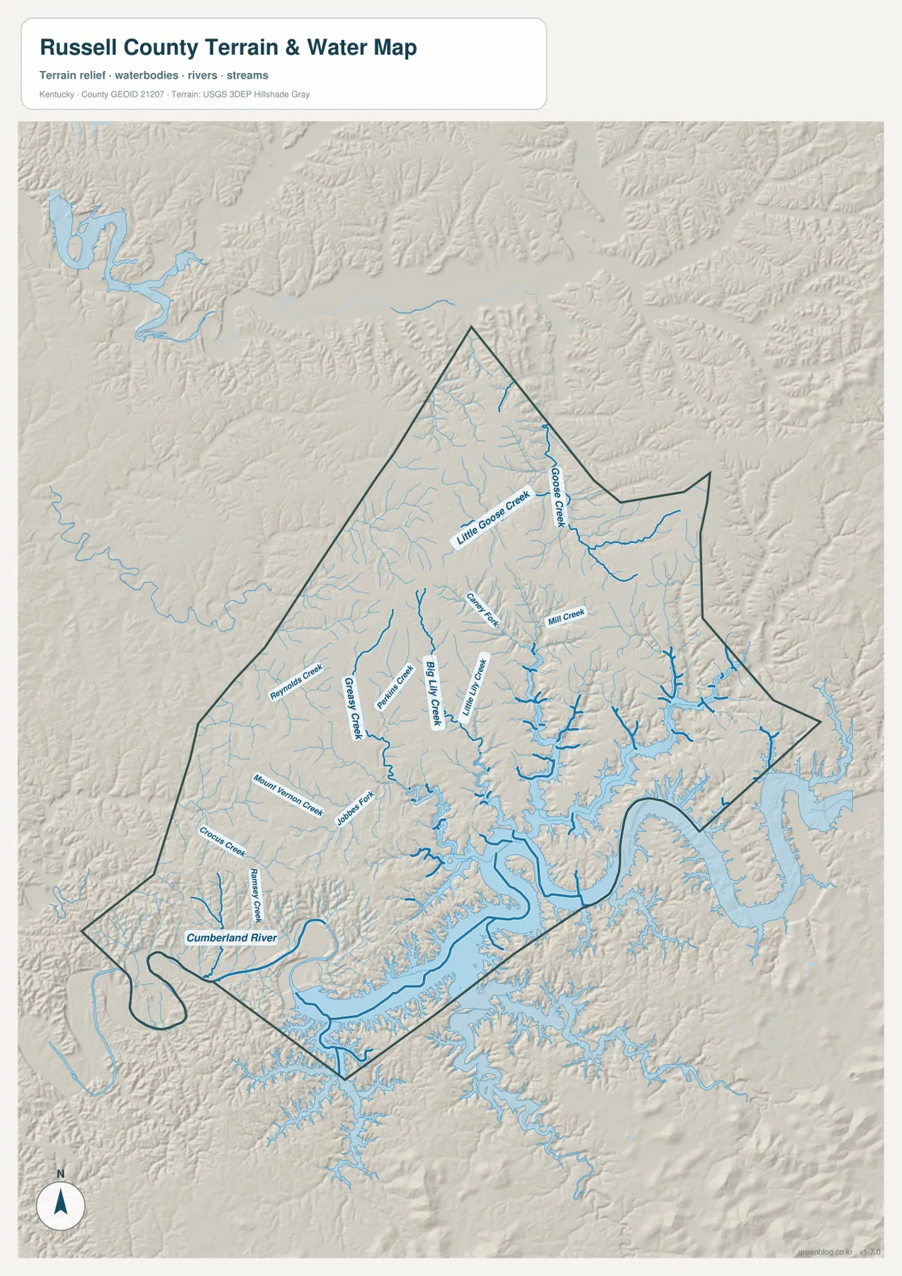
The terrain and water map is where Russell County’s physical structure becomes unmistakable. The Cumberland River is labeled across the southwest, while broad Lake Cumberland waters occupy much of the southern and eastern edge. The U.S. Army Corps of Engineers identifies Lake Cumberland as a major reservoir in the Cumberland River system that extends through Russell County and several neighboring Kentucky counties. On this map, the reservoir does not appear as one simple oval lake; it reaches inland through branching valleys and creates a long, highly irregular shoreline.
Smaller tributaries organize the northern and central uplands. Goose Creek and Little Goose Creek descend through the north. Beaver Creek and Mill Creek appear farther south, while Big Lilly Creek and Little Lilly Creek form a pair of prominent central valleys leading toward the lake. On the western side, Grassy Creek and Reynolds Creek cross lower corridors between ridges. Each stream is modest compared with the reservoir, but together they show how thoroughly the county has been cut into separate drainage basins.
The shaded relief behind the water network is important. Blue creek lines consistently occupy the lower spaces between ridges, and the larger lake arms fill the deepest valleys in the south and east. Big Lilly Creek and Little Lilly Creek provide a clear example: both run through elongated low corridors before reaching the broader reservoir system. The same pattern can be seen around Goose Creek in the north, where the valley remains narrow and the bordering ridges rise quickly on either side.
The southwest adds another contrast. Smaller streams such as Mount Vernon Creek, Crocus Creek, and Ramsey Creek feed toward the Cumberland River side, where the low terrain becomes broader. In the east, by comparison, reservoir arms repeatedly separate narrow ridges and peninsulas. A destination on the opposite side of one of those inlets may appear nearby on a flat map but require a much longer road approach. This relationship between water and accessibility is one of the most useful reasons to keep the terrain layer beside the road map.
This file is intended for county-scale geographic reference. It is not a flood-zone map, legal shoreline survey, parcel map, bathymetric chart, or boating-navigation product, and minor channels may be simplified at the displayed scale. Property, engineering, safety, and regulatory decisions require current official source data. For general study, however, the map clearly explains how the Cumberland River, Lake Cumberland, and many smaller creeks divide the county into upland ridges and water-bound valleys.
Relief drops from northern ridges toward the 166–348 m lake basin
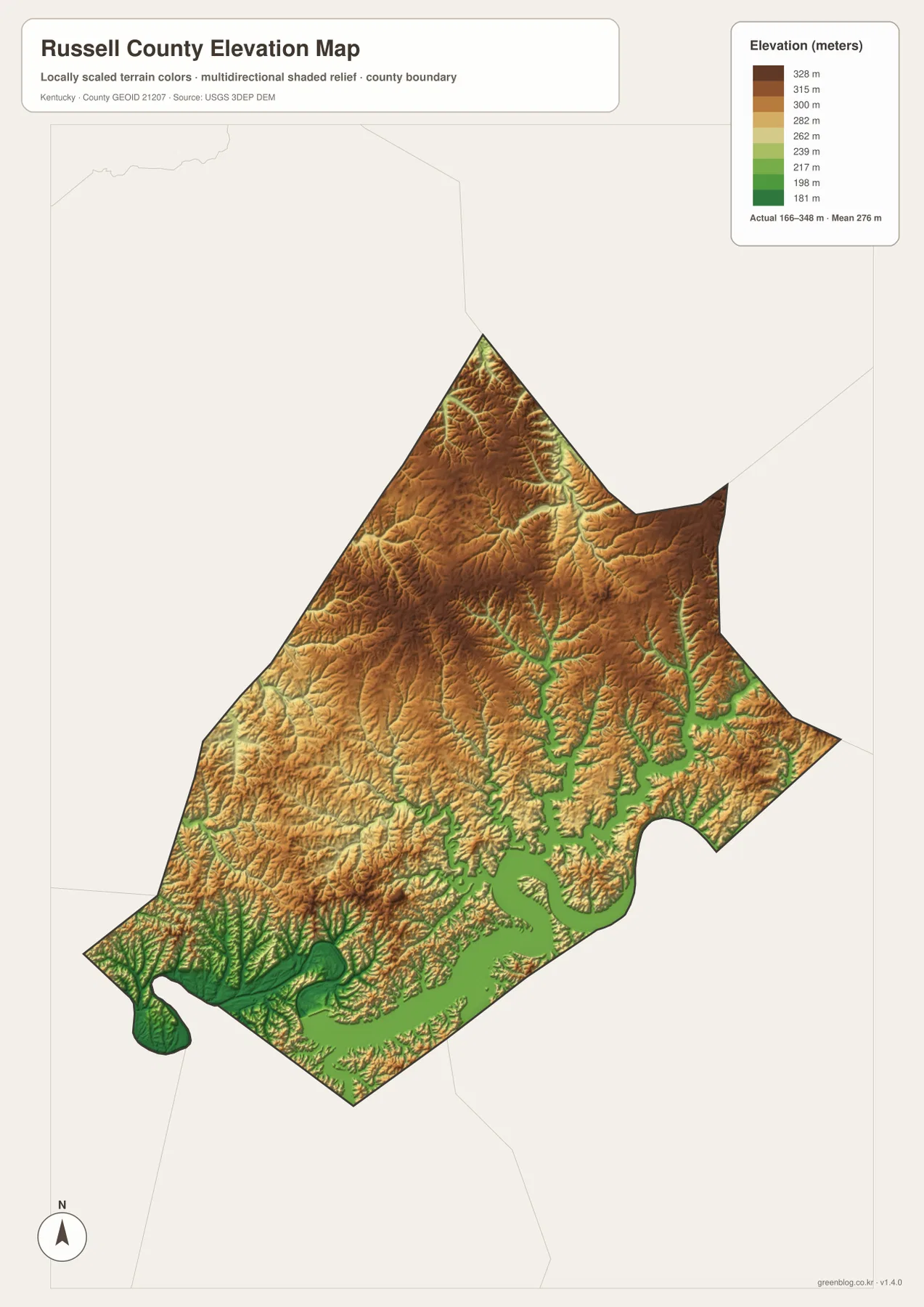
The elevation map reports an actual mapped range of roughly 166 to 348 meters and a mean near 276 meters. Green represents lower ground within the county, while yellow, tan, and brown indicate progressively higher terrain. The largest connected low area follows Lake Cumberland and the Cumberland River along the south, and narrow green fingers extend inland along tributary valleys. Higher ground dominates much of the north and northeast, producing a strong visual contrast across the county.
Russell Springs and Jamestown occupy a middle zone rather than the highest uplands or the lowest reservoir edge. The U.S. 127 corridor runs through rolling terrain where broader valley floors and gentler ridges provide a more continuous north-south passage. South of Jamestown, the map becomes greener as the land descends toward the lake. The branching reservoir then pushes low terrain far into the county, wrapping around higher ridge fingers and producing the irregular land-and-water pattern seen on the other maps.
Northern tributaries show the opposite relationship. Goose Creek and Little Goose Creek cut lower channels through broad areas of higher brown terrain. The valleys are narrow, so elevation can change quickly over a short horizontal distance from a stream bottom to a nearby ridge. Similar patterns occur east of the central corridor, where reservoir arms and creek valleys alternate with higher peninsulas. This is why the terrain-and-water map and the elevation map reinforce each other so well.
The southwest around the Cumberland River contains some of the lowest colors on the map. Moving north and northwest from that area, the surface rises into rolling uplands rather than one continuous mountain wall. Russell County is therefore better described by a repeating ridge-and-valley texture than by a single dominant summit. The elevation layer helps readers see that structure even where road labels and place names would otherwise hide the underlying terrain.
This generalized surface is designed for regional comparison, not survey-grade measurement. It should not be used to determine the exact elevation of a building site, calculate a construction grade, design drainage, or settle property questions. Those tasks require higher-resolution source data and professional measurement. For education, trip planning, and county-scale explanation, the 166–348 meter range is useful because it shows why the lake country appears lower and more dissected while the northern uplands remain higher.
Match the map file to roads, settlements, water, or terrain
Each file answers a different Russell County question. Use the general county map when Russell Springs, Jamestown, U.S. 127, KY 80, numbered state routes, and the full boundary need to appear together. The city map is cleaner when the goal is simply to compare the two main centers and the directions of neighboring counties. The terrain and water map is the strongest choice for Lake Cumberland, the Cumberland River, Goose Creek, Big Lilly Creek, and the branching valley system. The elevation map is best when the contrast between low shoreline terrain and higher northern uplands is the main subject.
- County map: best for Russell Springs, Jamestown, U.S. 127, KY 80, KY 76, KY 92, KY 55, boundary shape, and regional road orientation.
- City map: best for a clean comparison of Russell Springs and Jamestown and for seeing Casey, Pulaski, Cumberland, Adair, Wayne, and Clinton county directions.
- Terrain and water map: best for the Cumberland River, Lake Cumberland, Goose Creek, Big Lilly Creek, Little Lilly Creek, and the smaller tributary valleys.
- Elevation map: best for comparing lower reservoir and river terrain with higher northern and eastern ridges across the approximately 166–348 m range.
A useful reading sequence is to locate Russell Springs and Jamestown first, follow U.S. 127 between them, and then move to the water map to see how Lake Cumberland changes the southern half of the county. The elevation layer can be added last to explain why lake arms occupy deep valleys and why northern streams are confined between higher ridges. That sequence connects transportation, settlement, drainage, and relief instead of treating the four images as unrelated versions of the same place.
The original JPGs are 2572 × 3638 pixels each, which provides more room to inspect small route numbers, creek labels, and relief shading than the reduced web previews. For a printed handout, the county and city maps make a natural pair for human geography, while the terrain-and-water and elevation files work well together for physical geography. Choosing two maps that support the same topic is usually clearer than shrinking all four onto one page.
Frequently Asked Questions
Which map is best for comparing Russell Springs and Jamestown?
Use the city map for the cleanest comparison. It highlights Russell Springs to the north and Jamestown to the south while keeping the surrounding county directions visible. Use the general county map alongside it when you also need U.S. 127, KY 80, and the detailed road network connecting the two communities.
Which file shows Lake Cumberland, the Cumberland River, and smaller creeks together?
The terrain and water map is the strongest choice. It combines the Cumberland River and broad Lake Cumberland arms with Goose Creek, Little Goose Creek, Beaver Creek, Big Lilly Creek, Little Lilly Creek, Grassy Creek, and other tributaries, so the drainage and valley pattern can be viewed as one system.
Can the 166–348 meter elevation map be used for surveying or construction design?
No. The elevation map is a generalized county-scale surface for comparing low lake and river terrain with higher ridges. Its approximate 166–348 meter range and mean near 276 meters are useful for regional interpretation, but exact site elevations, grades, drainage design, and construction decisions require higher-resolution source data and professional surveying.
Sources and reference information
Road, settlement, water, and elevation descriptions are based primarily on the supplied Russell County map assets. County context for Jamestown and Russell Springs and background on Lake Cumberland were cross-checked against official Russell County and U.S. Army Corps of Engineers resources.
- Russell County Fiscal Court – About — Official county information covering Jamestown, Russell Springs, Lake Cumberland, and local geographic context.
- U.S. Army Corps of Engineers – Lake Cumberland — Official background on Lake Cumberland and its location in the Cumberland River system.
- U.S. Census Bureau TIGER/Line Shapefiles — Official U.S. geographic resources for county boundaries, roads, and related map layers.
- USGS National Hydrography — Official reference data for rivers, streams, lakes, and related hydrographic features.
- USGS 3D Elevation Program — Official U.S. elevation data and terrain-model information.
Map File Information
The ZIP contains the original high-resolution JPG versions of the Russell County road and boundary map, city map, terrain and water map, and elevation map. Review Russell Springs, Jamestown, the main roads, the Lake Cumberland drainage, and the 166–348 m relief on the page, then choose the file that fits your printing or reference needs.
- File Type: ZIP containing 4 JPG files
Related Maps
Green Map creates custom-edited map images using open geographic data sources such as geoBoundaries, Natural Earth, OpenStreetMap, and government open data. These maps are edited visual materials, not raw data files, and are provided for education, documents, presentations, and graphic reference.