Download the original high-resolution A3 JPG files for this Union County Arkansas Map from the ZIP on this page. The ZIP includes the county reference map, city map, terrain-and-water map, and elevation map, and the Download Map Files button appears near the end of the article. El Dorado is the main road center, while the terrain becomes lower and wetter toward Strong, Huttig, and Felsenthal in the east and southeast.
El Dorado sits slightly west of the county center, with Smackover and Norphlet to the north, Junction City near Louisiana, and a long road corridor extending east toward Strong and the Felsenthal side. Comparing the water and elevation maps shows a clear shift from rolling western ground cut by small creeks to broad lowlands with denser surface water near the eastern boundary.
Table of Contents
El Dorado connects the county’s main road corridors
El Dorado is the county seat and the strongest road hub in the map set. The city lies slightly west of the geographic center of Union County, with several state and U.S. routes meeting in or around the urban area. That makes it a natural starting point for locating the rest of the county rather than trying to follow every road from the boundary inward.
Highway 7 leads north from the El Dorado area toward Norphlet and Smackover, two communities that sit relatively close together. U.S. 82 provides a very different line of travel, carrying the eye east toward Strong and the long southeastern side of the county. These two corridors show how Union County is organized around a central city with separate northern and eastern branches.
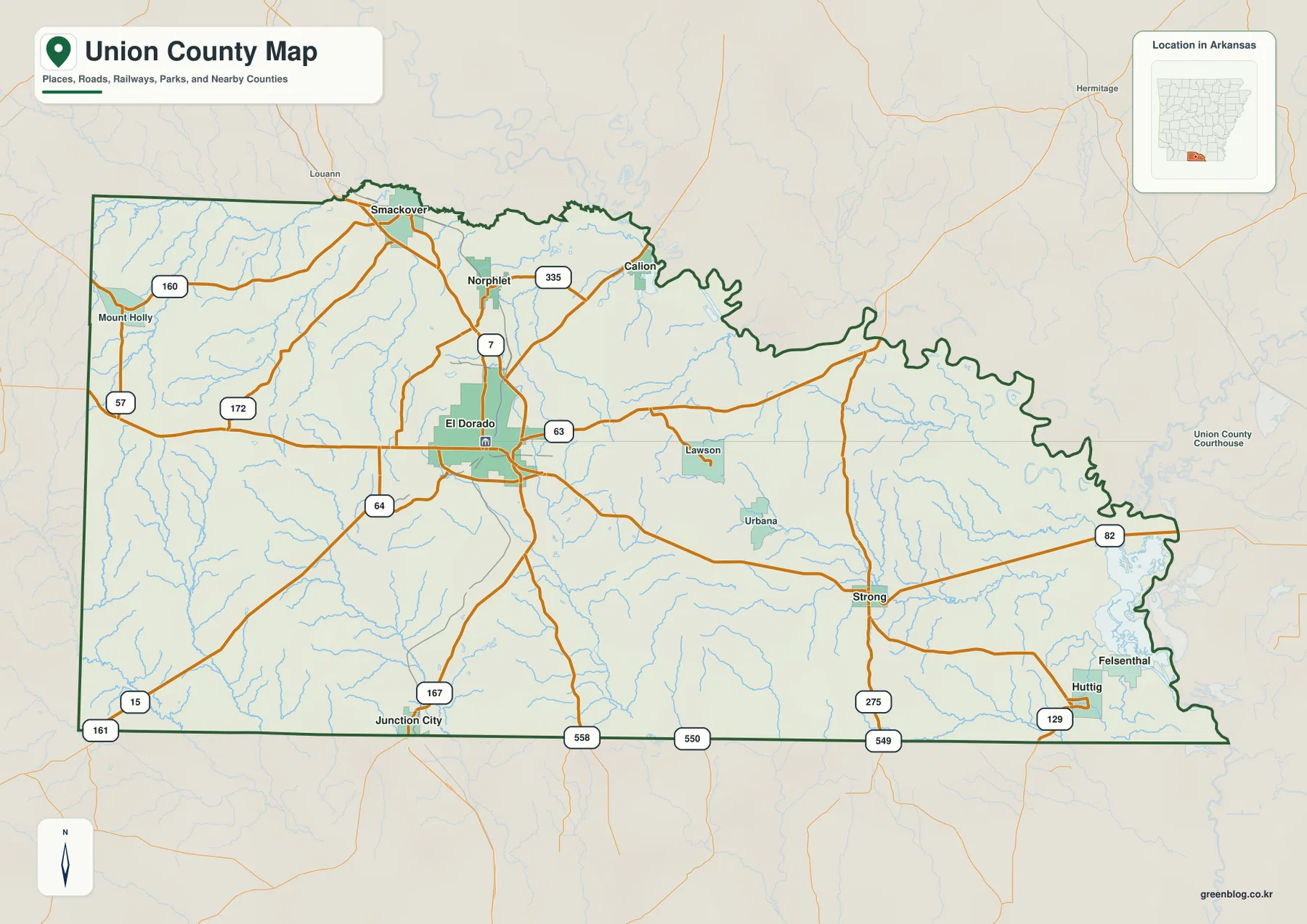
Junction City marks the southern side near the Louisiana line, reached from the El Dorado area along U.S. 167. Farther east, Strong serves as a useful intermediate point before the road network continues toward Huttig and Felsenthal. The distance between those eastern communities and El Dorado is easy to underestimate until the full county boundary is visible.
The city view reveals separate northern and southeastern groups
The simplified city graphic makes the spacing between the principal communities easier to see. El Dorado is the dominant center, while Smackover and Norphlet form the closest northern pair. Strong and Huttig are much farther east, and Junction City occupies a separate position near the southern boundary. This arrangement is more useful than a simple city ranking because it shows how spread out the county really is.
Several places visible on the reference map do not appear among the six emphasized city labels. Calion, for example, provides an additional northern-eastern landmark, and Felsenthal is important for understanding the far southeast even though it is not the main focus of the ranked city graphic. The reference map therefore remains the better choice when smaller communities matter.
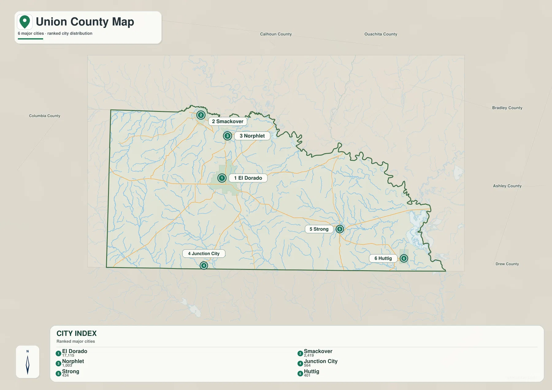
Any connector lines in the city graphic should be read as straight-line positional links rather than driving routes. Population figures printed on the supplied image are also best treated as comparison values, not as current Census estimates. The map’s main purpose is geographic: it shows which communities are close to one another and which sit in separate parts of the county.
Smackover Creek and smaller streams divide the rolling western terrain
The terrain-and-water map contains a dense network of creeks rather than one single river running through the interior. Smackover Creek is the most recognizable named stream in the northwestern section, with Beach Creek and Camp Creek nearby. Similar small channels cut through the ground around El Dorado and farther west, giving the rolling western half a pattern of short ridges separated by shallow valleys.
Farther east, the drainage becomes broader and the terrain flatter. Mini Creek and Bear Creek occupy separate low corridors, while named lakes such as Jones Lake appear in the eastern part of the county. The shift is gradual, but by the time the map reaches Huttig and Felsenthal, water features and low ground are much more prominent than they are near the western hills.
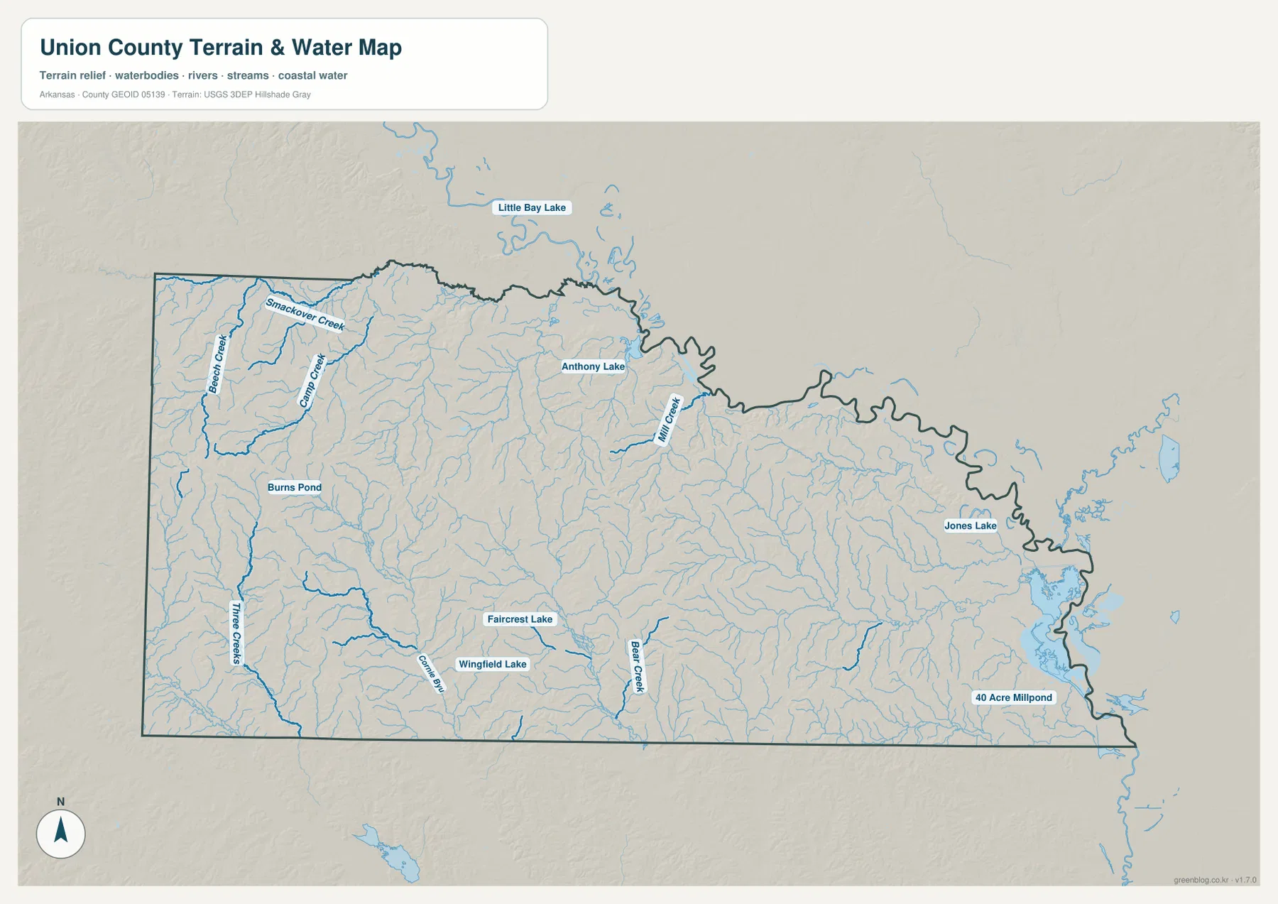
The U.S. Fish and Wildlife Service describes the Felsenthal National Wildlife Refuge landscape as a complex system of rivers, creeks, swamps, and lakes associated with the Ouachita and Saline river systems. That description fits the visual character of southeastern Union County. When the water map is paired with the elevation image, the wetland-rich eastern side makes geographic sense rather than looking like an isolated cluster of water features.
This is a county-scale water reference, not a flood-hazard map, parcel survey, navigation chart, or water-quality report. Use current specialized data from the responsible agencies when a decision involves flood risk, property boundaries, water conditions, or safe access.
The elevation map shows a clear west-to-east drop
The supplied elevation map gives Union County an actual range of about 16 to 115 meters, with a mean near 54 meters. Higher tan and brown ground is concentrated mostly in the west and southwest. Narrow green valleys cut between those hills, following the same small streams seen on the water map.
El Dorado sits in an intermediate setting. It is lower than the strongest western ridges but still above much of the broad eastern lowland. Moving east through Strong toward Huttig and Felsenthal, the map becomes increasingly green, showing flatter and lower terrain close to the eastern boundary.
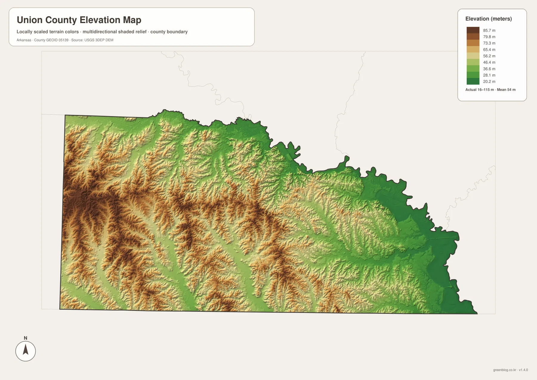
Union County’s official government site notes that the Ouachita River borders the county on the north and east. The supplied maps also show the eastern boundary as lower and more winding than much of the interior. The elevation and water views together help explain why the southeastern corner contains broader lowlands and a denser pattern of surface water.
The elevation colors are designed for broad terrain comparison, not survey-grade measurement. They should not be used for construction, parcel elevation, drainage design, engineering, or exact slope calculations. Detailed USGS 3D Elevation Program data or professional field measurements are the better source when precision matters.
U.S. 82 is a useful guide from El Dorado toward the lower east
For a first pass through the county, locate El Dorado and follow U.S. 82 east. The corridor leads toward Strong and continues across the long eastern side, making it easy to understand how far Union County extends beyond the county seat. Looking at the same route on the elevation map also shows the gradual transition into lower terrain.
The northern and southern directions can then be added without memorizing the entire road network. Highway 7 links the El Dorado area with Norphlet and Smackover, while U.S. 167 leads toward Junction City at the Louisiana line. Once those three corridors are established, smaller roads and communities are much easier to place.
Near the county edge, the dark boundary line is more reliable than the position of nearby labels. The eastern outline bends repeatedly, and the southern side meets Louisiana. When a town or road appears close to the edge, follow the boundary before assuming that the feature lies inside Union County.
Match the map to the question you are trying to answer
The county reference map is the best starting point for roads, towns, waterways, and the boundary in one view. The city graphic works better when the main goal is to compare the principal communities and their spacing. The terrain-and-water image is the clearest choice for Smackover Creek, smaller streams, lakes, and the wet southeastern side. The elevation map is best for explaining why the western half is hillier and the Felsenthal side is lower.
Two maps together can be especially useful in a lesson or local presentation. Pair the road and water views when discussing El Dorado, Smackover, and Norphlet. For Strong, Huttig, and Felsenthal, compare the water and elevation images so the relationship between low ground and abundant surface water is immediately visible.
Each downloadable JPG is 3638 × 2572 pixels, making the originals suitable for A3 landscape printing, zooming into labels, or placing a map in a report. Keep the original aspect ratio when resizing so roads, creeks, and the county boundary are not stretched, and check printer margins before producing multiple copies.
Frequently Asked Questions
What is the county seat of Union County, Arkansas?
El Dorado is the county seat. It sits slightly west of center and is the county’s strongest road hub, making it the easiest place to start when locating Smackover, Norphlet, Strong, Junction City, and the southeastern communities.
Why is the Felsenthal side lower and wetter?
Eastern and southeastern Union County contain broad lowlands below the rolling western terrain. The elevation map becomes greener toward Felsenthal, while the water map shows more winding channels, lakes, and wetland-like features in the same general area.
Can the water map be used to determine flood risk?
No. It is a county-scale reference for the location of creeks, lakes, and other water features. Flood risk, parcel boundaries, navigation, and current water conditions require specialized, up-to-date information from the responsible agencies.
Map File Information
The ZIP contains the original Union County reference, city, terrain-and-water, and elevation maps as high-resolution JPG files.
- Included Files: County reference map, city map, terrain-and-water map, elevation map
- Printable Size: 3638 × 2572 pixels each
- File Type: Four high-resolution JPG files in one ZIP archive
Related Maps
Sources and References
- Union County, Arkansas – Official Government Website – County government information, El Dorado, and background on the county’s location and Ouachita River boundary.
- Encyclopedia of Arkansas – Union County – Geographic and historical background for Union County.
- U.S. Fish & Wildlife Service – Felsenthal National Wildlife Refuge – Official information about the southeastern river, creek, swamp, and lake environment.
- USGS National Hydrography – Official information about U.S. rivers, streams, lakes, and hydrographic data.
- USGS 3D Elevation Program – Official elevation and terrain data information.
Green Map creates custom-edited map images using open geographic data sources such as geoBoundaries, Natural Earth, OpenStreetMap, and government open data.
These maps are edited visual materials, not raw data files, and are provided for education, documents, presentations, and graphic reference.