Stone County sits in the Ozark Mountains of north-central Arkansas, with Mountain View near the middle of a landscape cut by steep creek valleys and long ridges. The White River forms the northeastern edge of the county, while the North and South Sylamore creek systems drain much of the northern interior. South of Mountain View, the terrain rises into broad highland areas that look very different from the lower river and creek corridors to the north and east.
Download the original high-resolution A3 JPG files from this Stone County Arkansas Map set in one ZIP near the end of the page. The package contains the county reference map, city-distribution map, terrain-and-water map, and elevation map. Use the reference view for Mountain View, Fifty-Six, Pleasant Grove, Fox, and roads; use the water and elevation views when the main question is how Ozark ridges and creek valleys shape the county.
Table of Contents
Mountain View is the practical center for reading Stone County
Mountain View is the county seat and the clearest starting point on the reference map. Stone County’s official website identifies Mountain View as the county seat, and the Encyclopedia of Arkansas explains that the community was selected when the county was created in 1873. On the map, Mountain View sits slightly east of center where several roads meet, including Arkansas Highways 14, 58, and 5.
From Mountain View, the main place names spread in different directions. Fifty-Six is north of the county seat along the Highway 14 corridor, with Highway 87 also visible nearby. Pleasant Grove lies to the east along Highway 58, while Fox is southwest of Mountain View. Along the southern edge, Highways 9, 263, and 18 provide additional reference points. Highways 66 and 110 appear toward the western side.
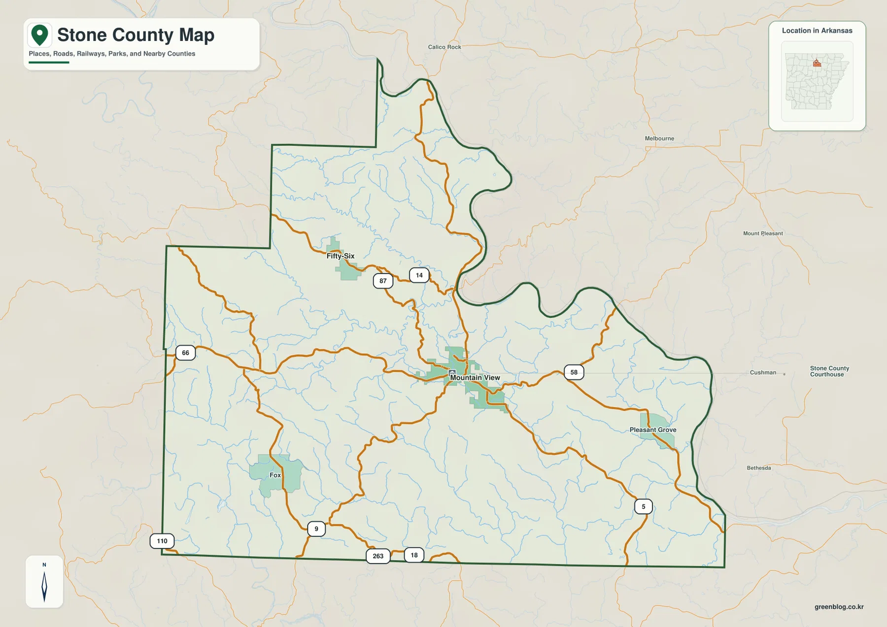
The county outline is not a simple rectangle. The north and east sides bend repeatedly, especially where the county approaches the White River. The western and southern edges contain longer straight sections but also several offsets. When checking a road or stream near the edge, follow the dark county boundary rather than assuming that every nearby label belongs to Stone County.
The city view reduces the county to Mountain View and Fifty-Six
The supplied city-distribution graphic highlights two major places: Mountain View and Fifty-Six. Mountain View sits near the center of the county and is ranked first in the graphic, while Fifty-Six is positioned to the north. The simplified layout removes most of the smaller place labels so the direction and spacing between these two communities are easy to compare.
The reference map still matters because it contains additional communities such as Pleasant Grove and Fox. The city graphic is therefore best used for a quick overview rather than as a complete settlement map. For actual travel between Mountain View and Fifty-Six, return to the reference map and follow the numbered roads rather than treating the simplified city view as a route map.
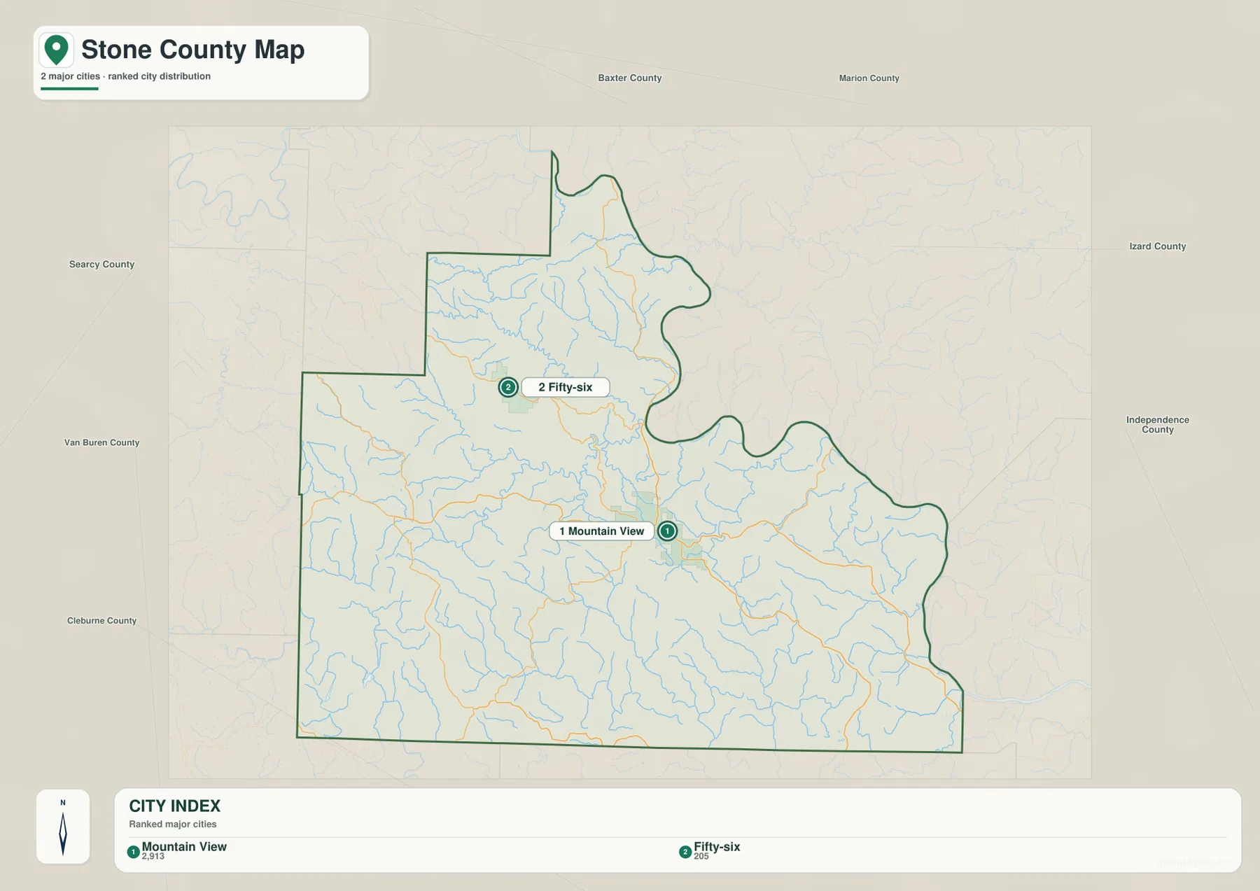
The population figures printed in the graphic should be treated as comparison values in the supplied image, not as a substitute for the latest Census estimate. The useful information here is positional: Mountain View is the county’s main center, while Fifty-Six provides a clear northern landmark close to the Sylamore creek country.
North and South Sylamore creeks cut through the northern Ozark hills
The terrain-and-water map is especially detailed in the northern half of Stone County. North Sylamore Creek runs through the north-central area and receives numerous short tributaries before continuing toward the eastern side. South Sylamore Creek occupies a separate valley farther southwest. Roasting Ear Creek and West Livingston Creek are also labeled in the northern drainage network, making the area around Fifty-Six easy to distinguish.
The Encyclopedia of Arkansas notes that the White River forms Stone County’s northeastern border and that spring-fed creeks, including the South Sylamore, are tributaries of the river. That regional relationship is visible in the supplied maps even when the county boundary itself is the strongest line along the northeast. Short streams descend through steep terrain and collect into larger creek valleys that lead toward the White River side.
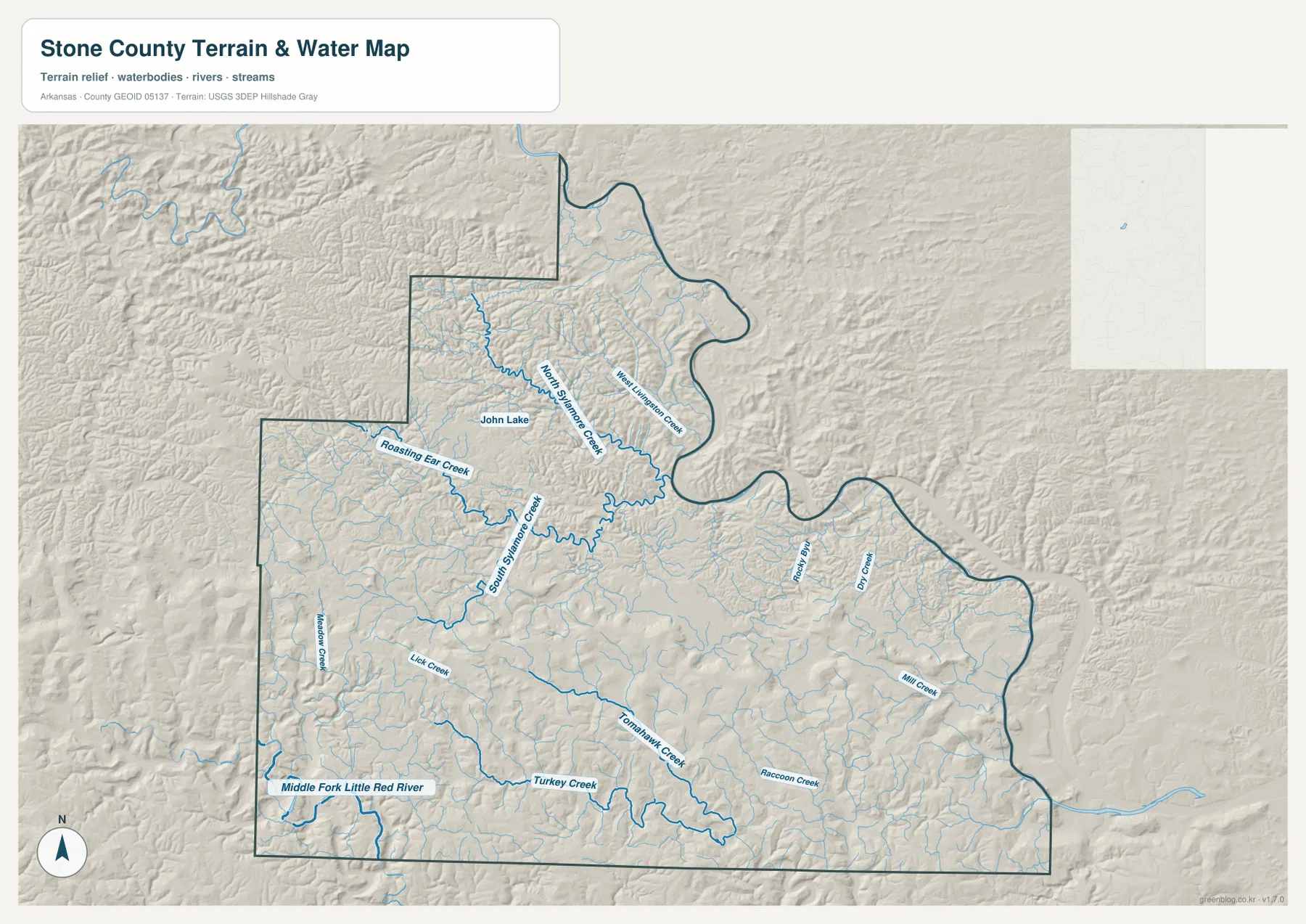
Farther south, the named waterways change. Lick Creek, Tomahawk Creek, Turkey Creek, and Raccoon Creek follow lower corridors between ridges, while the Middle Fork Little Red River appears near the southwestern and southern edge. Rather than one dominant river crossing the entire county, Stone County contains many short, branching creeks shaped by the surrounding Ozark relief.
This water map is intended for county-scale geographic reference. It does not show current flood-hazard limits, legal parcel lines, water quality, or safe navigation routes. Those decisions require current specialized information from the responsible agencies. Here, the value of the map is showing where the named streams sit relative to the hills, roads, and county boundary.
The southern highlands rise far above the river and creek valleys
The elevation image shows a large range of relief within Stone County. The supplied map lists an actual elevation range of about 79 to 561 meters, with a mean near 276 meters. Lower green terrain follows many northern and eastern valleys, while the southern and southwestern half contains broad areas of tan and brown high ground. The contrast is strong enough that the county’s terrain changes are obvious even at a small scale.
Mountain View occupies a middle position between these extremes. Moving southwest toward Fox or farther south from the county seat, the highland colors become more extensive. Moving northeast toward the White River side, the land drops into lower valleys. North Sylamore Creek also creates a clear low corridor through otherwise rugged hills, showing how water has followed and deepened the lower parts of the landscape.
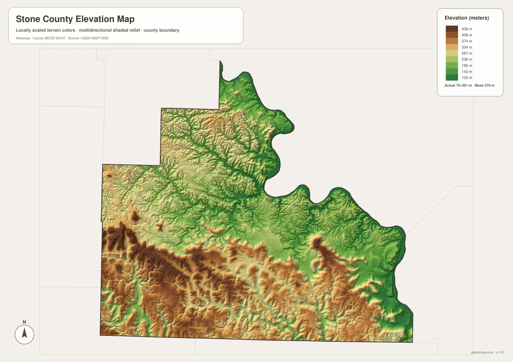
Stone County’s official government site describes the county as rugged and hilly because of its location in the Ozark Mountains. The elevation map gives that statement a clear geographic shape: the southern half contains repeated high ridges, and the stream map shows creeks using the lower valleys between them. Pairing the two views is useful when explaining why roads and settlements often follow lower corridors rather than crossing the highest ground directly.
The elevation colors are not survey-grade measurements for individual properties. They are appropriate for comparing higher and lower parts of the county, but not for construction, drainage design, engineering, or exact slope calculations. Detailed USGS 3D Elevation Program data or professional field measurements are better choices when precise elevations are required.
Use Mountain View and the White River side to establish direction
A simple way to orient yourself is to find Mountain View first, then look northeast toward the deeply curved county boundary. That is the White River side of Stone County. Highway 14 leads north from Mountain View toward Fifty-Six, while Highway 58 extends east toward Pleasant Grove. Once those locations are fixed, the rest of the road network becomes easier to follow.
Next, switch to the water map and locate North Sylamore Creek and South Sylamore Creek. Their valleys organize much of the northern terrain. In the south, the Middle Fork Little Red River and smaller named creeks help identify the lower corridors between high ridges. Looking at those same areas on the elevation image makes the difference between the northern valleys and southern highlands immediately visible.
Several labels outside the boundary provide additional context, including Calico Rock, Melbourne, Mount Pleasant, and Cushman. They are useful for understanding which direction neighboring communities lie, but they should not be confused with places inside Stone County. The dark county outline remains the best guide for separating local features from nearby outside labels.
Pick the map according to the detail you need
The county reference map is the best starting point for Mountain View, Fifty-Six, Pleasant Grove, Fox, major roads, and nearby counties. The city view is much simpler and works when you only need the relative position of Mountain View and Fifty-Six. The terrain-and-water map provides the strongest view of the Sylamore creeks and southern tributaries, while the elevation map is best for the high southern Ozarks and lower river valleys.
For a lesson or presentation, two maps can work especially well together. Pair the reference and water views to explain how Mountain View and Fifty-Six relate to the Sylamore creek system. Pair the water and elevation images to show why short tributaries occupy narrow valleys between high ridges. That approach keeps the discussion focused on visible county-specific features rather than a generic list of map types.
Each downloadable JPG measures 3638 × 2572 pixels and is suitable for A3 landscape printing, zooming into labels, or placing the map in a document. Keep the original aspect ratio when resizing so roads, streams, and the county boundary are not stretched. Printer margins vary, so a single test print is useful before producing a larger set.
Frequently Asked Questions
What is the county seat of Stone County, Arkansas?
Mountain View is the county seat. It sits near the center of the road network and is the easiest place to use as a starting point for locating Fifty-Six, Pleasant Grove, Fox, and the main highways.
Where is the White River in relation to Stone County?
The White River forms the northeastern border of Stone County. Several spring-fed creek systems, including the Sylamore drainage, lead toward the White River side of the county.
Why is southern Stone County much higher on the elevation map?
The southern and southwestern parts of Stone County contain broad high Ozark ridges, while the northern and eastern river and creek valleys are lower. The supplied elevation map shows an overall range of about 79 to 561 meters.
Map File Information
The ZIP contains the original Stone County reference, city-distribution, terrain-and-water, and elevation maps as high-resolution JPG files.
- Included Files: County reference map, city-distribution map, terrain-and-water map, elevation map
- Printable Size: 3638 × 2572 pixels each
- File Type: Four high-resolution JPG files in one ZIP archive
Related Maps
Sources and References
- Stone County, Arkansas – Official Government Website – County history, Mountain View, and background on the rugged Ozark landscape and natural areas.
- Encyclopedia of Arkansas – Stone County – Geographic and historical background on the White River, Sylamore creeks, Ozark National Forest, and Stone County.
- U.S. Census Bureau TIGER/Line – Official geographic data information for county boundaries and related mapping layers.
- USGS National Hydrography – Official information about U.S. rivers, streams, lakes, and hydrographic data.
- USGS 3D Elevation Program – Official elevation and terrain data information.
Green Map creates custom-edited map images using open geographic data sources such as geoBoundaries, Natural Earth, OpenStreetMap, and government open data.
These maps are edited visual materials, not raw data files, and are provided for education, documents, presentations, and graphic reference.