High-resolution Tunica County map files are available from this page. The four supplied views separate the town of Tunica from Tunica Resorts and North Tunica, follow US 61 through the county, and show the winding Mississippi River landscape along the western side. Old River Lake, Tunica Lake, White Oak Bayou, Coldwater River, and other channels add detail that a simple road map cannot show. The elevation view records an actual county range of about 16 to 98 meters, revealing subtle differences across the Delta lowlands. The download archive contains county, city, water, and elevation maps as A3 JPG files.
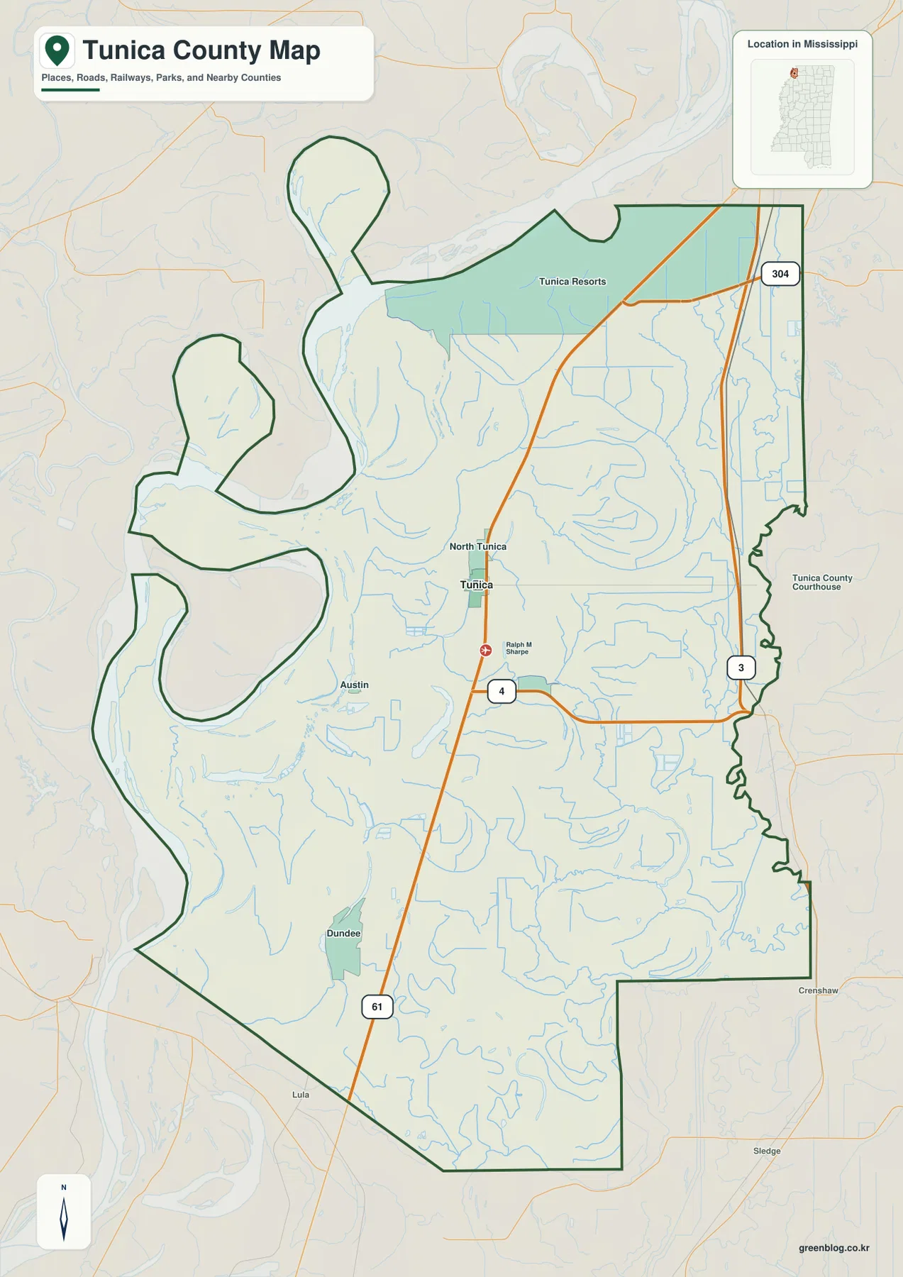
Tunica County is visually unusual because its western outline bends repeatedly around the Mississippi River landscape. Current channels, isolated lakes, older-looking river loops, straight agricultural drainage lines, and long highways all appear within the same county. Tunica itself sits inland from the river, while Tunica Resorts lies well to the north. That separation is important for anyone using the map for travel or regional explanation: the county seat and the resort district should not be treated as one continuous downtown.
Table of Contents
Tunica, Tunica Resorts, and the US 61 corridor
US 61 is the easiest road to use as an internal reference. It runs north-south through the western interior, passing the Tunica area and continuing toward North Tunica and the resort side before reaching the DeSoto County direction. South of Tunica, the same corridor continues toward Dundee and Coahoma County. Following this one road first makes the settlement pattern much easier to understand than beginning with the irregular river boundary.
MS 4 leaves the Tunica area toward the east and connects with MS 3, which runs along the more agricultural eastern side of the county. MS 304 appears in the northeast and provides another reference toward DeSoto County. The general map does not attempt to include every casino access road, levee road, or farm lane. Its strength is showing how the main road network relates to Tunica, the resort area, and the county edge.
The county map also labels the courthouse area, Ralph M. Sharpe, Austin, and Dundee. These smaller references help distinguish the interior from the river-facing resort side. Because the western edge contains large bends and projecting pieces of county land, a place that looks close across a river loop may require a much less direct road route. The combination of US 61 and the water map is therefore more useful than straight-line distance alone.
Why the ranked city map centers on Tunica
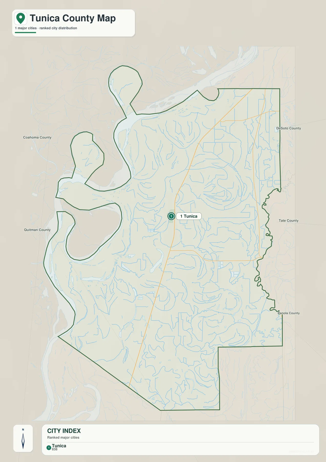
The city map is deliberately simpler than the general county view. It gives Tunica the main ranked city marker and uses DeSoto, Tate, Panola, Quitman, and Coahoma counties as outside orientation points. Tunica Resorts and North Tunica remain useful geographic labels on the broader county map, but they are not presented as separate ranked cities in this particular city graphic.
That difference helps define the job of each map. Use the city view when the question is simply where Tunica sits within the county and among its neighbors. Switch to the general map when the resort district, Dundee, Austin, US 61, MS 3, and the river-side outline all need to be visible at once. Keeping those purposes separate avoids turning one graphic into an unreadable collection of labels.
Mississippi River bends, cutoff lakes, and interior bayous
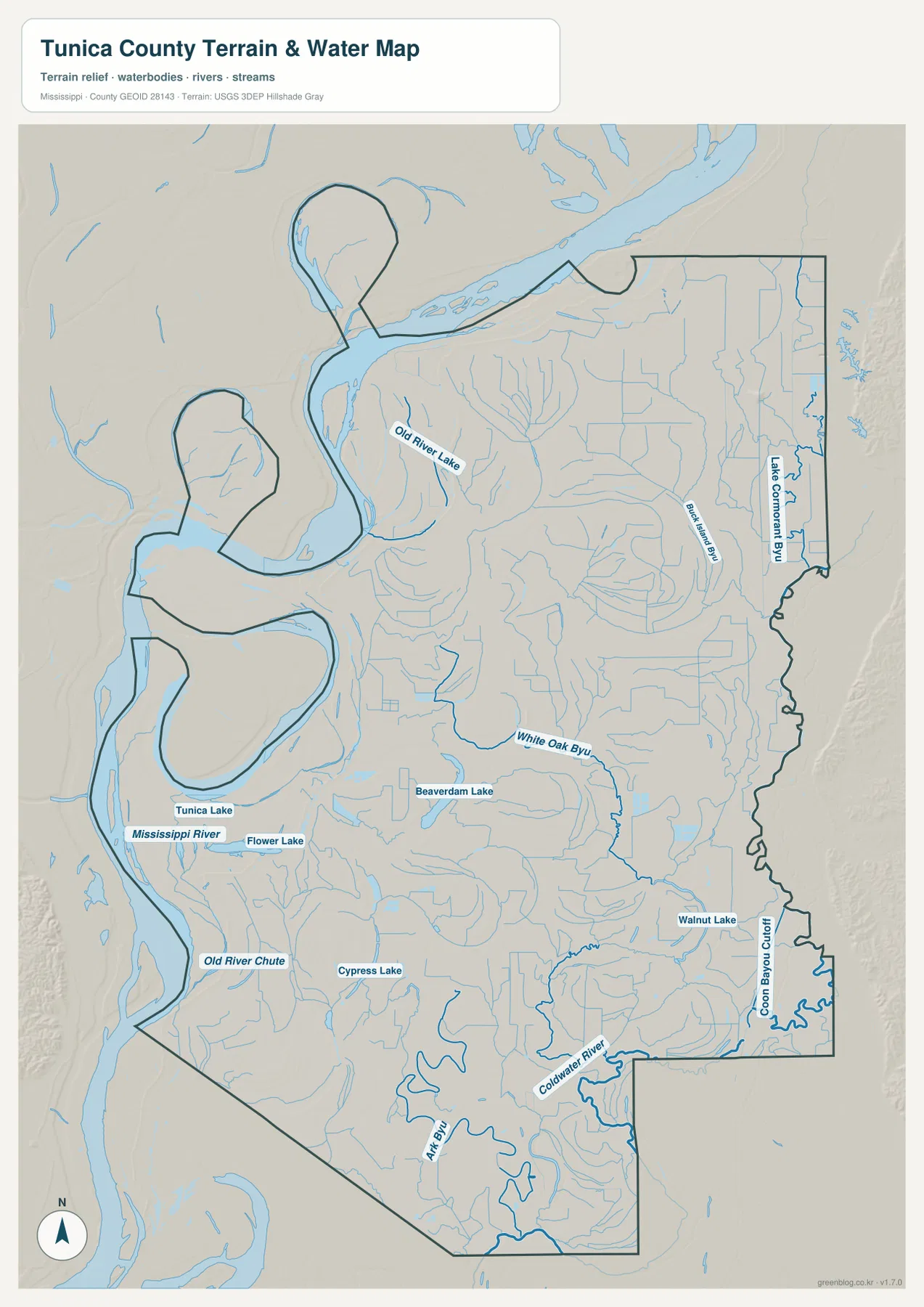
The terrain-and-water map is dominated by the Mississippi River on the west. The present channel makes broad bends beside the county, while separate water bodies occupy nearby loops and depressions. Old River Lake is labeled in the northwest, and Tunica Lake appears farther south. Old River Chute is marked in the lower-western section, with Flower Lake and Cypress Lake nearby. Taken together, these features make the river’s long history visible in a way that a straight road network cannot.
The county interior has its own named waterways. White Oak Bayou curves through the center. Black Island Bayou and Lake Cormorant Bayou occupy the northeastern side, while Core Bayou Cutoff appears near the southeast edge. Coldwater River forms a large meandering channel in the south. These waterways are smaller than the Mississippi River, but they matter for understanding the low terrain and the many drainage paths crossing the agricultural plain.
Beaverdam Lake and Walnut Lake provide additional inland reference points. The density of blue lines does not mean every channel has the same size, purpose, or navigability. Some are rivers, some are bayous or cutoffs, and others are small lakes or drainage features. For general geography, the map shows how these waters fit together; navigation, levee management, or flood decisions require more specialized sources.
The county boundary itself deserves attention. Several western lobes and deep indentations do not match a simple straight administrative line, and the supplied existing material notes that river movement and legal boundaries can make the relationship with the current channel complicated. When a precise Mississippi-Arkansas or county boundary is needed, a current official boundary dataset is more appropriate than judging from the visible river centerline alone.
What a 16–98 meter elevation range looks like in the Delta
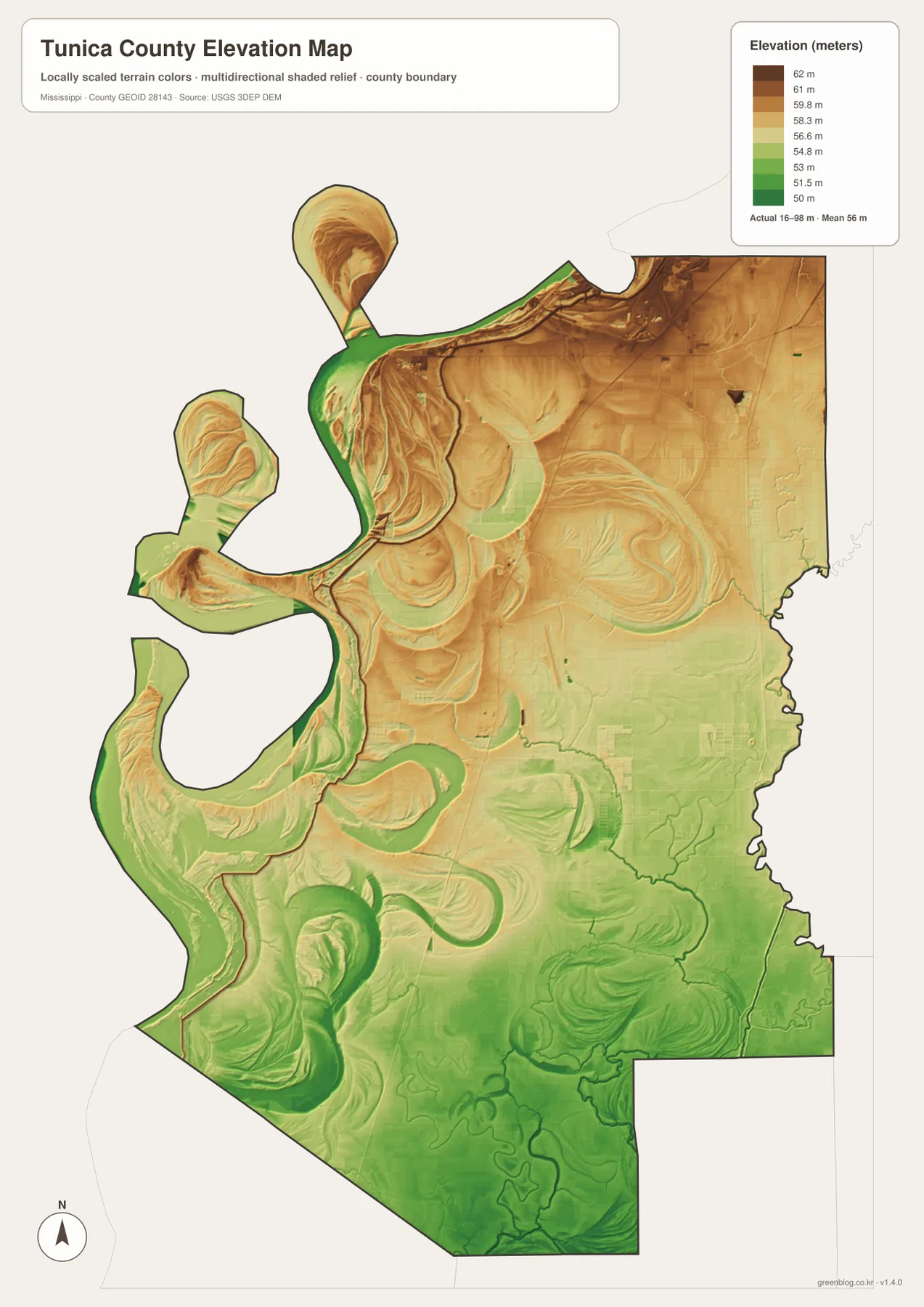
The elevation map gives an actual range of about 16 to 98 meters and a mean of about 56 meters. Most of Tunica County is low, but the surface is not featureless. Warmer brown tones are more common across the north and northeast, while greener low ground spreads through much of the south and southeast. Along the Mississippi River side, curving low bands trace the shapes of present and former river-related terrain.
Large crescents and looping forms are especially noticeable in the west. Some correspond closely with Old River Lake, Tunica Lake, and other water features; other curved landforms sit away from the current channel. The pattern is useful for seeing how a very flat floodplain can still contain meaningful local relief. It should not, however, be used by itself to label every curve as an abandoned channel or to infer a flood zone.
At this scale, the elevation map works best as a comparison tool. It can show which broad parts of the county are lower, where river-related corridors stand out, and how the north differs from the southern lowlands. Exact field elevations, levee heights, engineering grades, drainage plans, and flood-insurance questions require much more detailed data than a county overview can provide.
Population, land area, and the separate resort district
The package’s Census references give a 2020 census population of 9,782 and a July 2025 estimate of 8,819. They come from different reference dates and should be read as separate measures of county size rather than like-for-like observations. The 2025 Gazetteer values list 454.130 square miles of land and 22.013 square miles of water. Using the 2020 population with that land figure produces about 21.5 residents per square mile.
That countywide average combines very different settings. Tunica contains the courthouse and local services, the northern Tunica Resorts area concentrates hotels, casinos, and event facilities in the supplied existing description, and broad stretches of agricultural and river-adjacent land lie between or beyond them. The map makes this separation easier to understand than the density figure alone: activity is concentrated in particular places rather than spread evenly across every square mile.
Choosing the Tunica County map that fits the task
Choose the general county map when Tunica, Tunica Resorts, Dundee, US 61, MS 3, and the county edge need to appear together. The city map is cleaner when Tunica itself and the neighboring-county context are the main questions. The water map is the strongest option for Mississippi River bends, Old River Lake, Tunica Lake, White Oak Bayou, and Coldwater River. The elevation map adds the physical explanation by showing the subtle low corridors and slightly higher ground across the Delta.
For classroom or presentation use, the county and water maps make a useful pair because the settlement-and-road pattern can be compared directly with the river-shaped western side. A physical-geography explanation benefits more from the water and elevation maps together: curved water bodies and low elevation bands can be compared without assuming that every bend represents the same kind of feature.
Frequently Asked Questions
Is Tunica Resorts the downtown of Tunica?
No. The supplied county map and existing material place Tunica Resorts north of the county seat rather than inside one continuous Tunica downtown. Readers looking for the hotel and casino district should distinguish that area from the town of Tunica.
Does the western county boundary always follow the center of the current Mississippi River channel?
It should not be assumed to do so in every segment. The supplied map shows complex river bends, separated water bodies, and an irregular county outline, while the existing material notes that river movement and legal boundaries can make some sections more complicated. Use a current official boundary source when the precise state or county line matters.
Map File Information
The ZIP contains the Tunica County county, city, water, and elevation maps as high-resolution A3 JPG files. The originals provide more room for labels and linework than the WebP page previews when printing, editing, or preparing classroom graphics.
- File Type: four high-resolution JPG files in one ZIP
Related Maps
Sources and References
- U.S. Census Bureau QuickFacts for Tunica County — population reference
- U.S. Census Bureau Gazetteer Files — land and water area reference
- Mississippi Department of Transportation Official Highway Map — US 61, MS 3, MS 4, and state-road reference
- USGS National Hydrography — river, bayou, and lake reference
- USGS 3D Elevation Program — elevation and terrain reference
- Tunica Airport — regional transportation reference
Green Map creates custom-edited map images using open geographic data sources such as geoBoundaries, Natural Earth, OpenStreetMap, and government open data. These maps are edited visual materials, not raw data files, and are provided for education, documents, presentations, and graphic reference.