You can download four high-resolution A3 JPG maps of Lamb County in one ZIP directly from this page. The set includes a general county map, a ranked city map, a terrain-and-water map, and an elevation map. Together they show Littlefield, Olton, Sudan, Earth, Amherst, Springlake, Spade, roads marked 84, 70, 385, and 303, several named lakes, and an elevation range from about 1,034 to 1,180 meters.
Littlefield is the easiest place to use as an anchor because it lies near the southern-central part of the county and sits close to both the route marked 84 and the north-south route marked 385. From there, Amherst and Sudan extend northwestward, while Earth, Springlake, and Olton occupy the northern half. The water map adds a different set of reference points, especially Soda Lake in the northwest and Bull Lake, Illusion Lake, and Yellow Lake in the southwest.
Table of Contents
Littlefield and Route 84 organize the southern half of the map
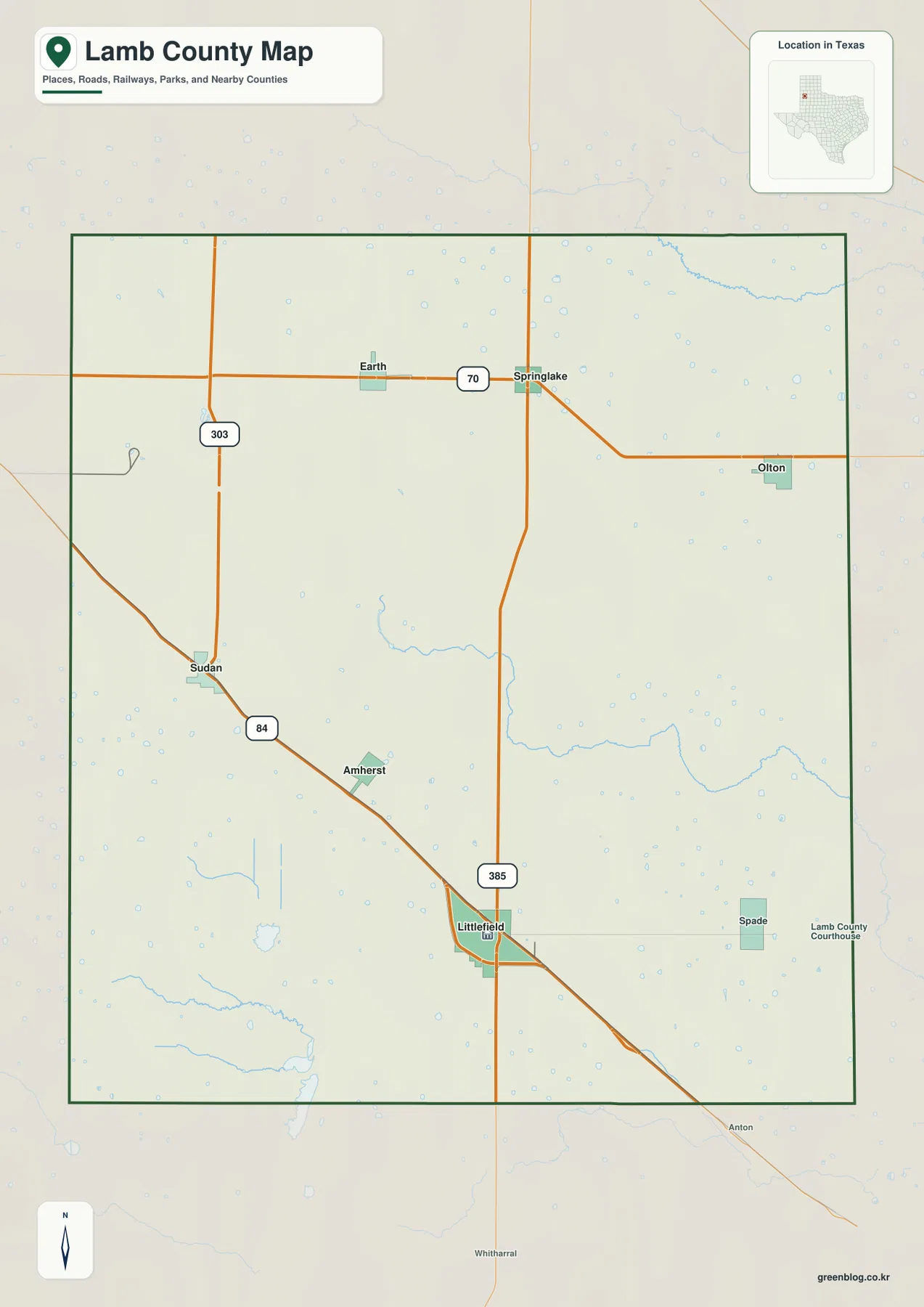
On the general map, Littlefield is the most prominent settlement label. Route 84 passes through the Littlefield area and continues northwest toward Amherst and Sudan. Route 385 runs north-south nearby, so the two roads provide a simple framework for reading the southern half of the county. Spade is labeled east of Littlefield, while the county courthouse marker appears near the eastern side of the Littlefield area.
Following Route 84 northwest gives a clear sequence of settlements. Amherst lies between Littlefield and Sudan, and Sudan sits closer to the western boundary. The road continues beyond the county, which helps show that the mapped corridor is not limited to local travel. Route 385, by contrast, provides a strong vertical reference through Littlefield and toward the northern half of the map.
Route 70 connects a separate group of communities across the north
The northern part of the general map has its own east-west pattern. Route 70 passes Earth and Springlake before bending toward Olton in the northeast. A road marked 303 appears west of Earth, and a north-south road meets Route 70 near Springlake. This makes the northern settlement pattern distinct from the Littlefield-Amherst-Sudan corridor along Route 84.
Olton is set well to the east of Earth and Springlake rather than forming a tight cluster with them. The spacing between these places is easy to see because the background contains relatively few large settlement labels. Comparing the two main corridors—Route 84 in the southwest and Route 70 in the north—shows why one single line does not explain the county’s urban pattern.
The city index makes the six main settlements easy to compare
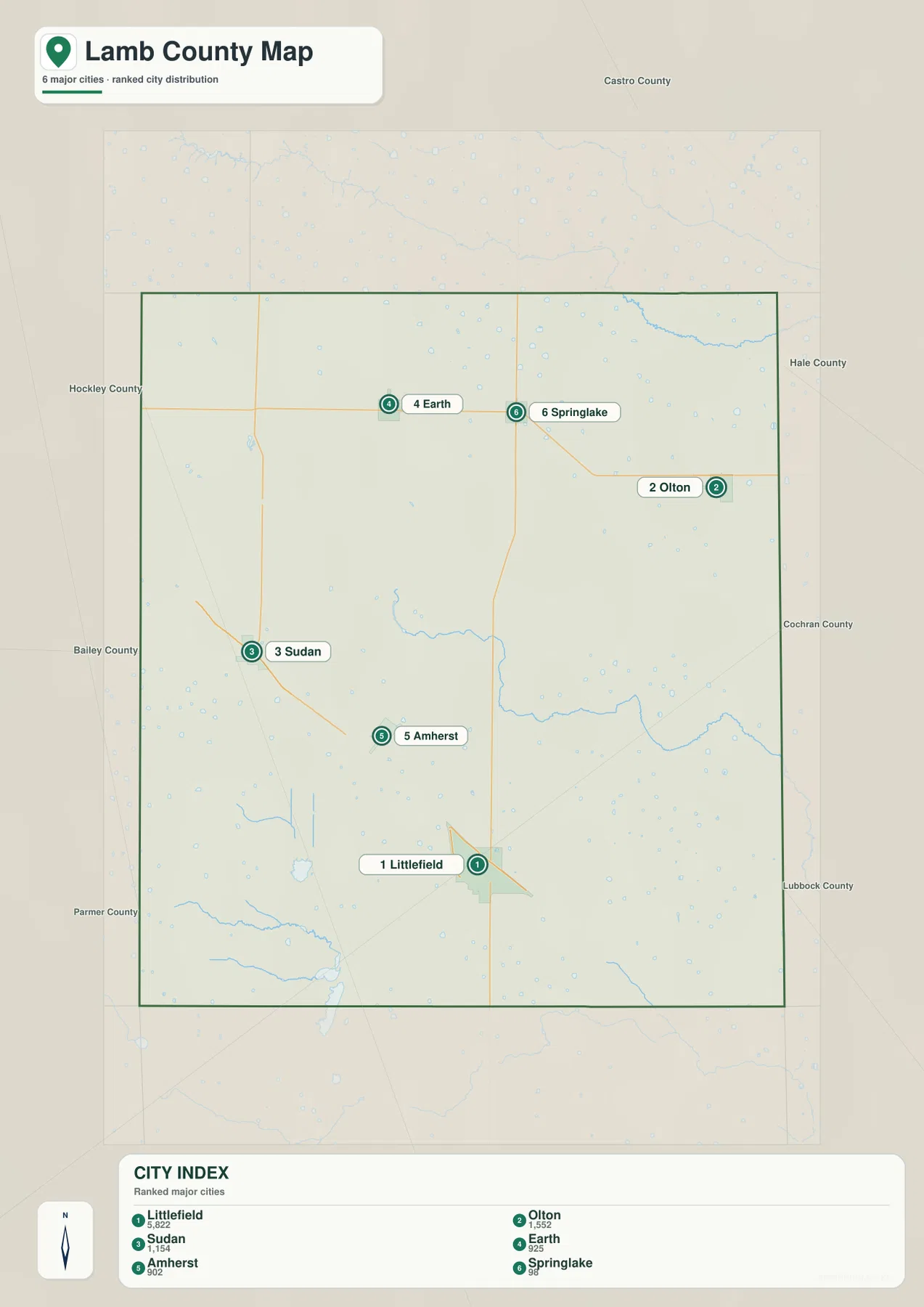
The ranked city map simplifies the road detail and labels six major communities. Littlefield is ranked first, followed by Olton, Sudan, Earth, Amherst, and Springlake. Their markers are spread across much of the county: Littlefield is in the south-central area, Olton in the northeast, Earth and Springlake in the north, and Sudan and Amherst on the western side.
This view is useful when the goal is to compare relative position rather than trace a driving route. Littlefield is clearly separated from the northern cities, and Olton is noticeably farther east than Earth. Sudan and Amherst form another western pair at different distances from Littlefield. The general map should be used alongside this index when road numbers are important, since the ranked view intentionally removes much of that detail.
Named lakes provide the clearest water references in the county
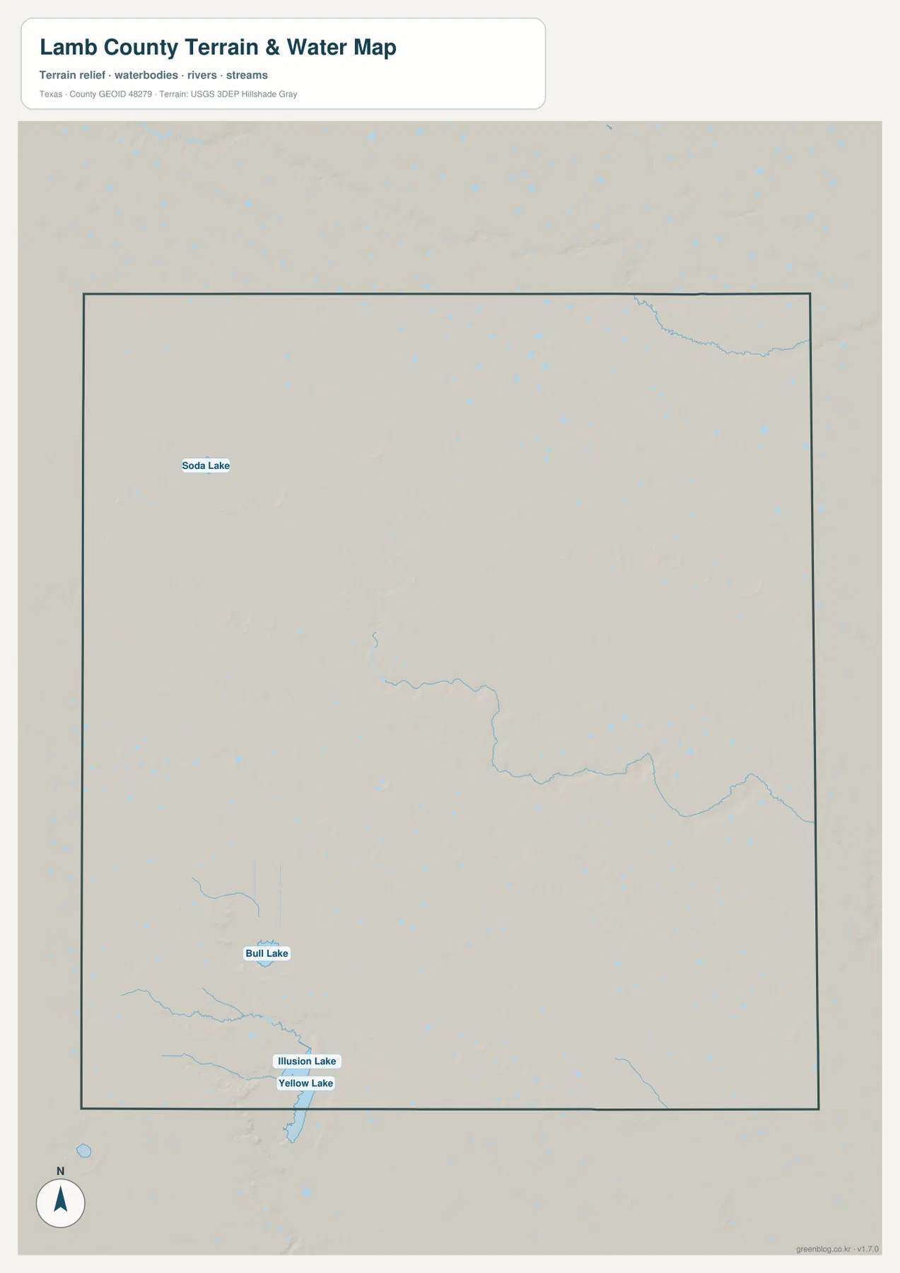
The terrain-and-water map removes most road and city labels and makes the water features easier to see. Soda Lake is labeled in the northwestern part of the county. Farther south, Bull Lake appears in the southwestern interior, while Illusion Lake and Yellow Lake are positioned close together near the southern boundary. These four names are the clearest labeled water references on the supplied map.
Yellow Lake is the largest of the labeled southwestern features in the preview, with Illusion Lake immediately to its north. Bull Lake lies farther north, creating a useful sequence for comparing the southwestern part of the county. Numerous small blue marks are scattered across the map, and several longer unnamed channels cross the central and eastern areas, but the article keeps the discussion centered on the names that can be read directly from the provided image.
The general map shows many of the same water lines, although they are less prominent because roads and place names share the page. Switching between the two views helps locate a lake relative to a town or highway. For example, the water map is better for identifying Yellow Lake or Soda Lake, while the county map is better for judging where that feature sits in relation to Littlefield, Sudan, or the northern road network.
Elevation drops from the western side toward the east and southeast
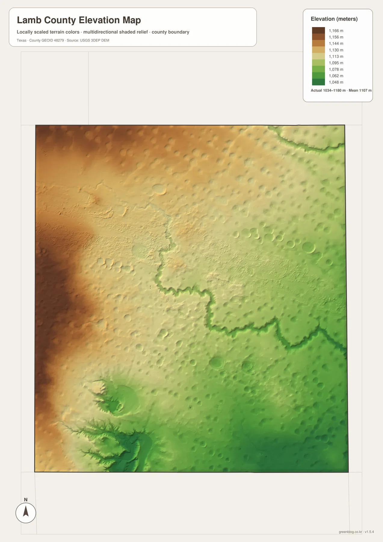
The elevation map reports an actual range of about 1,034 to 1,180 meters, with a mean of about 1,107 meters. Browns and tans dominate the western and northwestern side, indicating the higher ground. Greens become more extensive toward the east and southeast. The total relief is about 146 meters, so the map shows a broad, gradual change rather than a dramatic mountain landscape.
A branching lower corridor crosses the central and eastern part of the elevation map and resembles the position of channels visible on the water map. The southwest also contains distinct lower green areas surrounded by slightly higher terrain. These patterns are easier to recognize on the shaded elevation image than on the general road map, where subtle height differences are not the main focus.
Using Littlefield as a common reference makes the comparison practical. The western side around the Sudan-Amherst corridor generally falls within higher colors than the eastern side, while the map becomes greener toward the southeast. This does not mean every point changes at the same rate, but it gives a clear county-wide direction for the elevation pattern shown in the supplied data.
The four views answer different location questions without changing the county outline
For roads and settlements, the general county map is the most detailed starting point. It places Littlefield, Olton, Sudan, Earth, Amherst, Springlake, and Spade together with the numbered routes. The city index is cleaner when only the six ranked major communities need to be compared. The water view removes much of that urban detail and brings the named lakes forward, while the elevation view shows the west-to-east height change.
Two maps are often more useful than one. A reader can locate Sudan or Littlefield on the county map and then check the same part of the elevation map to compare height. Someone looking for Bull Lake or Yellow Lake can begin with the water map and return to the general map for nearby roads and towns. Because each image uses the same county boundary, these comparisons do not require a new orientation each time.
High-resolution JPG files make small labels easier to inspect
The web previews are convenient for a full-county view, but smaller labels such as Route 303, Soda Lake, or Illusion Lake may be difficult to read on a small screen. The ZIP below contains the county, city, terrain-and-water, and elevation maps as high-resolution A3 JPG files. They can be enlarged for close inspection or used as separate printed maps when only one type of information is needed.
Frequently Asked Questions
What is the easiest way to locate Littlefield and the other major communities?
Start with Littlefield near the southern-central part of the general map and find Route 84. Amherst and Sudan lie northwest along that corridor. Earth, Springlake, and Olton are in the northern half near Route 70, while Route 385 provides a useful north-south reference through the Littlefield area.
Which named lakes are shown on the water map?
The supplied terrain-and-water map labels Soda Lake, Bull Lake, Illusion Lake, and Yellow Lake. Soda Lake is in the northwest, while the other three are concentrated in the southwestern part of the county.
What elevation range is shown for Lamb County?
The elevation map lists an actual range of about 1,034 to 1,180 meters and a mean of about 1,107 meters. Higher colors are concentrated in the west and northwest, while lower green terrain becomes more common toward the east and southeast.
Sources and Reference Data
- U.S. Census Bureau TIGER/Line Shapefiles — official boundary and road geometry for geographic reference.
- USGS National Hydrography — official resources for lakes, streams, and other water features.
- USGS 3D Elevation Program — official elevation resources used for terrain information.
- USGS The National Map Viewer — an official viewer for comparing multiple geographic layers.
Map File Information
Download four high-resolution A3 JPG maps of Lamb County in one ZIP file.
- Included Files: county map, city map, terrain and water map, elevation map
- File Type: JPG
Related Maps
- Bailey County Texas map
- Parmer County Texas map
- Randall County Texas map
- Swisher County Texas map
- Terry County Texas map
Green Map creates custom-edited map images using open geographic data sources such as geoBoundaries, Natural Earth, OpenStreetMap, and government open data.
These maps are edited visual materials, not raw data files, and are provided for education, documents, presentations, and graphic reference.