Download the Elmore County Idaho Map as one ZIP containing high-resolution A3 JPG versions of the county overview, city, terrain-and-water, and elevation maps. The WEBP previews below let you inspect Mountain Home, Glenns Ferry, Interstate 84, the Snake River, Boise River headwaters, reservoirs, and relief before opening the larger files for printing, classroom work, reports, or presentations.
Elmore County spans two very different landscapes. Mountain Home and Glenns Ferry sit in the lower southern part of the county on or near the Snake River Plain, while the northern half rises into deeply cut mountain country drained by the Boise River system. The county’s own history page describes the landscape as roughly 60 percent mountainous and 40 percent Snake River Plain, a contrast that is immediately visible when the water and elevation maps are compared.
Table of Contents
Mountain Home anchors the road network on the southern plain
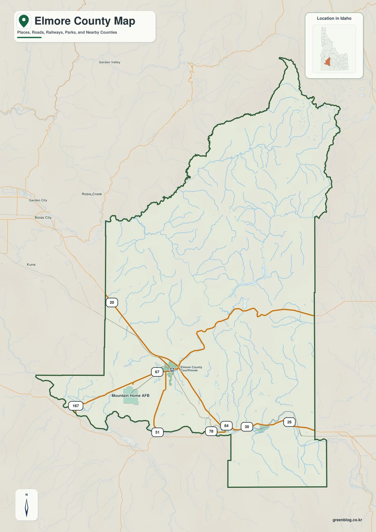
The county overview makes Mountain Home the easiest starting point. Elmore County’s official history page records that the county was created in 1889 and that Mountain Home became the permanent county seat in 1891. The courthouse label appears in the city, and several major roads meet or branch nearby, giving Mountain Home a strong role in the southern transportation pattern.
Interstate 84 and US 30 continue east from Mountain Home toward Glenns Ferry. US 20 heads northwest into the interior, while Idaho 67 connects Mountain Home with Mountain Home Air Force Base. Idaho 51 and 78 appear farther south and southwest, tying the city to the lower country closer to the Snake River.
The county boundary is relatively simple across parts of the south but becomes much more irregular in the mountains to the north. Boise County is labeled above the western mountain area, Ada and Owyhee counties lie to the west and southwest, and Camas and Gooding counties are on the eastern side. The shape helps explain why a single county includes both broad plain and rugged high country.
Mountain Home and Glenns Ferry define the two main city references
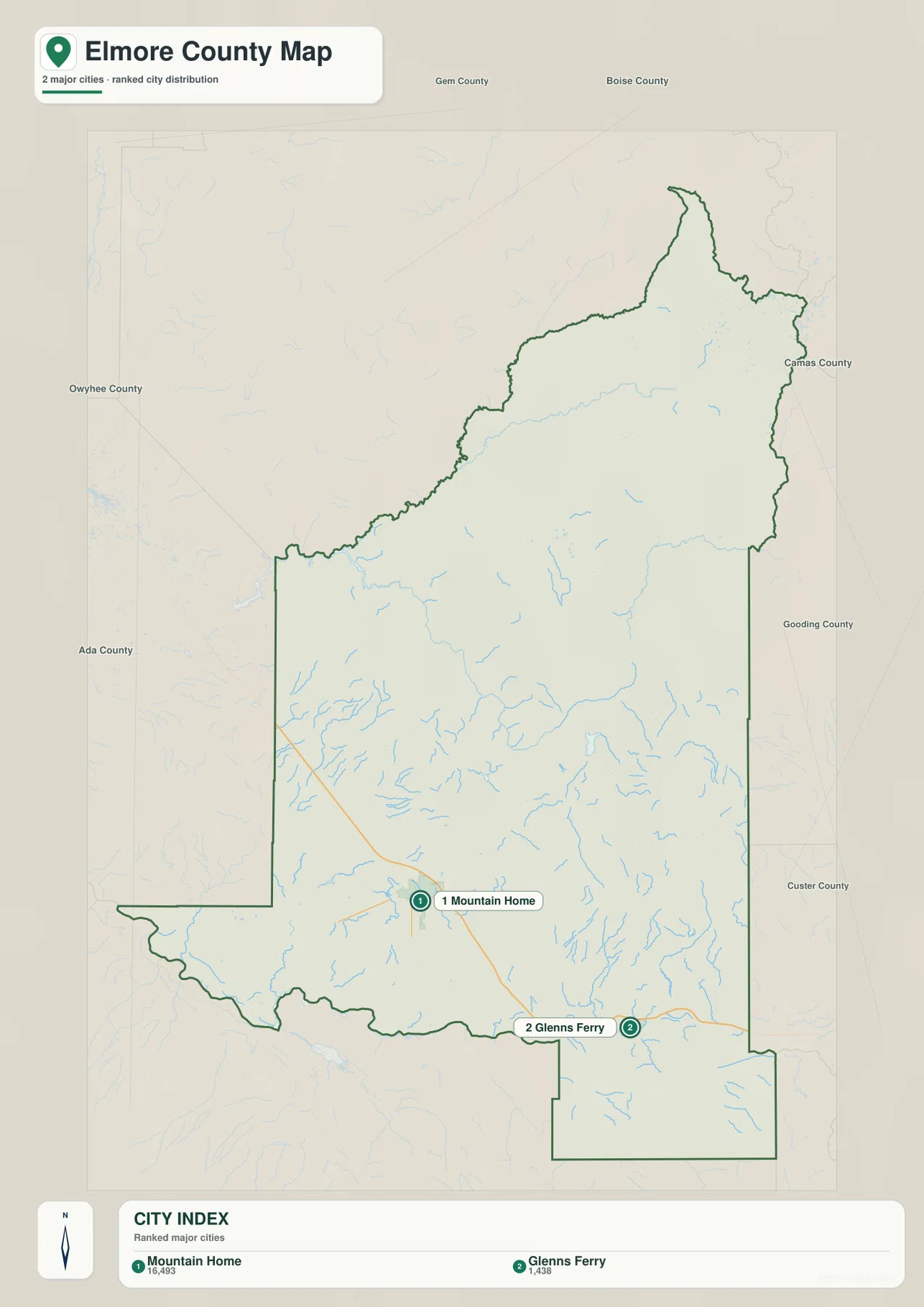
The city map highlights only Mountain Home and Glenns Ferry. Mountain Home ranks first in the supplied city index and Glenns Ferry second. Both are in the lower southern part of Elmore County, but they are separated along the east-west transportation corridor rather than forming one continuous urban area.
Mountain Home is the administrative and transportation center, while Glenns Ferry provides a strong reference point for the eastern Snake River side of the county. Elmore County’s history page and Idaho State Parks both connect the Glenns Ferry area with Three Island Crossing, a major Oregon Trail crossing of the Snake River. That history gives the city a geographic role that is easy to connect with the river map.
The city map does not include connector-distance labels, so it should not be used to estimate a precise straight-line or driving distance between the two communities. Its value is in quickly showing that Mountain Home sits farther west and Glenns Ferry farther east, both well south of the county’s extensive mountain interior.
Boise River mountain waters descend toward the Snake River plain
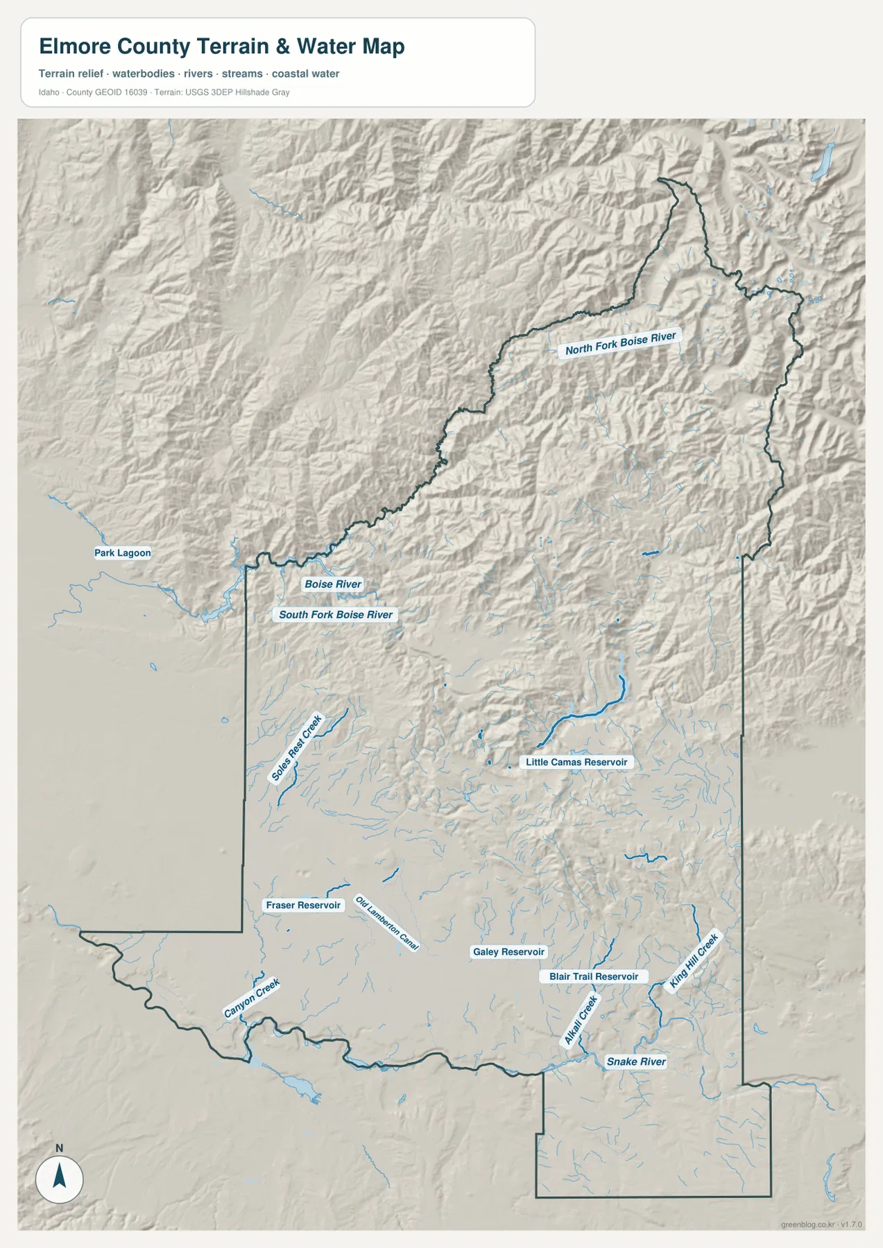
The terrain-and-water map changes character dramatically between north and south. In the mountains, North Fork Boise River is the strongest named waterway across the northern and northeastern part of the county. Boise River and South Fork Boise River appear in the northwest, cutting through deeply shaded valleys and steep ridges.
Farther south, the water features become more widely spaced across gentler ground. Little Camas Reservoir is a prominent landmark east of the center, while Fraser Reservoir, Galey Reservoir, and Blair Trail Reservoir are labeled across the southern half. Canyon Creek appears toward the southwest, and Alkali Creek and King Hill Creek are among the named southeastern drainages.
The Snake River follows the southern edge and provides the clearest lowland reference for the county. Comparing it with the Boise River system shows why Elmore County has such a broad elevation range: mountain streams begin in very high country and descend toward much lower southern terrain. This map is a geographic reference for rivers, creeks, and reservoirs; it is not a flood-hazard map, depth chart, navigation product, parcel map, or legal water-right document.
Elevation climbs from the Mountain Home plain to high northeastern ridges
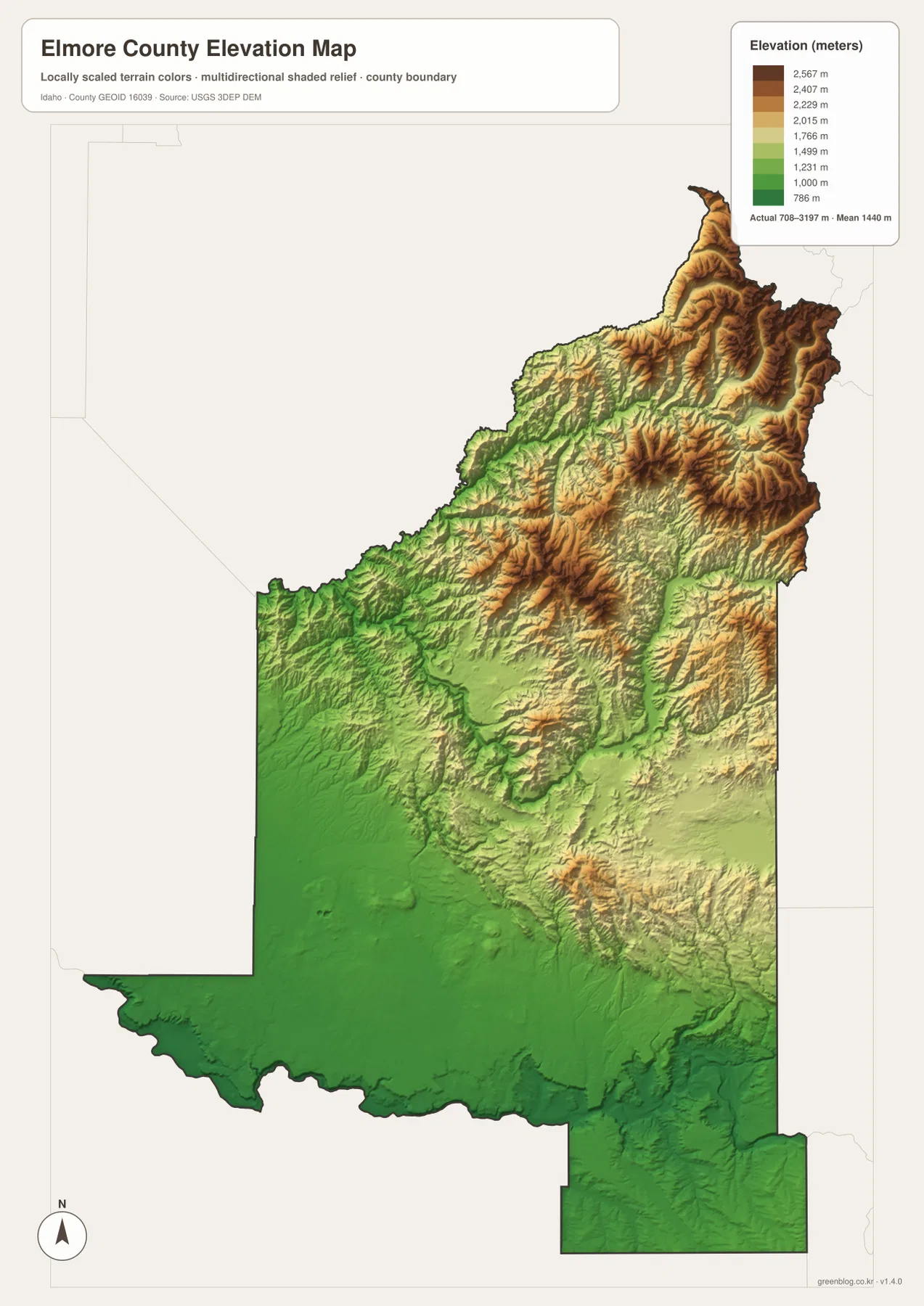
The elevation map shows the southern half of Elmore County in broad green tones, marking the lower and gentler Snake River Plain. Mountain Home and Glenns Ferry occupy this lower setting. Moving north, the colors rise through lighter green and yellow before reaching extensive tan and brown mountain terrain.
The supplied elevation graphic reports an actual range of about 708 to 3,197 meters, with a mean near 1,440 meters. The highest colors are concentrated across the northern and northeastern mountains, while the Snake River edge and the Mountain Home area remain among the lowest parts of the county. Stream valleys cut lower green corridors between the high ridges, matching the drainage pattern visible on the water map.
The colors are intended for county-scale comparison rather than property-level measurement. They are useful for understanding why the main southern roads and cities occupy flatter ground and why the northern rivers run through narrow mountain valleys. A survey or engineering project would require a more precise elevation source for an individual site.
Reading the southern transportation corridor against the northern headwaters
For general orientation, begin with the city map to locate Mountain Home and Glenns Ferry, then move to the county overview to add Interstate 84, US 30, US 20, Idaho 67, and Mountain Home Air Force Base. This sequence makes the southern road pattern easy to understand before the much more complex mountain terrain is introduced.
The terrain-and-water map is the next step when the Boise River system, Little Camas Reservoir, or the Snake River is the main interest. Once those water features are located, the elevation map explains why the northern drainage network is dense and steep while the southern part of the county is broader and flatter.
This combination works well for classrooms, local research, trip planning, reports, and presentations. A reader can trace Mountain Home from the city map to the road network, compare Glenns Ferry with the Snake River and Three Island Crossing area, and then use the elevation map to understand the enormous difference between the southern plain and the northern high country.
Frequently Asked Questions
Where are Mountain Home and Glenns Ferry on the map?
Both are in the lower southern part of the county. Mountain Home is the administrative and transportation center, while Glenns Ferry lies farther east toward the Snake River corridor. Interstate 84 and US 30 provide the clearest road reference between their general locations.
Which waterways stand out in the northern mountains?
North Fork Boise River is the strongest named waterway in the northern and northeastern mountain area, and Boise River and South Fork Boise River are also labeled in the northwest. The water and elevation maps show these rivers cutting through much higher terrain than the southern plain.
How large is the elevation difference across Elmore County?
The supplied elevation map reports an actual range of roughly 708 to 3,197 meters. The Mountain Home and Snake River plain is low, while the northern and northeastern mountains rise far above it.
Map File Information
The ZIP contains high-resolution A3 JPG versions of the Elmore County overview, city, terrain-and-water, and elevation maps.
- File Type: JPG files inside one ZIP archive
Related Maps
Sources and references
- Elmore County official history and geography page
- Idaho State Parks — Three Island Crossing State Park
- U.S. Census Bureau TIGER/Line Shapefiles
- USGS National Hydrography
- USGS 3D Elevation Program
Green Map creates custom-edited map images using open geographic data sources such as geoBoundaries, Natural Earth, OpenStreetMap, and government open data.
These maps are edited visual materials, not raw data files, and are provided for education, documents, presentations, and graphic reference.