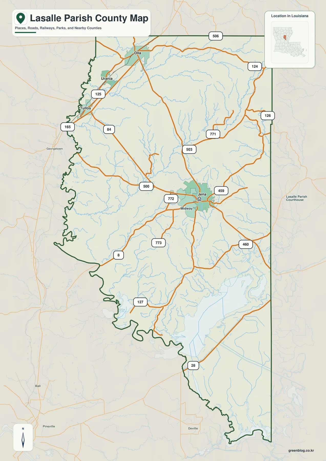
LaSalle Parish in central Louisiana is organized around Jena, where several roads converge, while Tullos, Urania, and Olla form a separate group of communities toward the northwest. South of Jena, settlement labels become less prominent and the map increasingly fills with streams, lake margins, and irregular boundary bends near Catahoula Lake. This page uses those visible features to explain the parish rather than treating every map as a separate checklist. The high-resolution JPG files corresponding to the map previews can also be downloaded together in a ZIP. High-resolution map files are available for download in the section below.
Jena is the most useful orientation point. Louisiana’s official LaSalle Parish profile identifies Jena as the parish seat and lists Olla, Tullos, and Urania among the parish municipalities; Midway is also shown immediately west of Jena on the supplied map. That creates two easy reference areas: the Jena–Midway center and the northwestern string of Tullos, Urania, and Olla. Once those places are located, the larger road network and the more water-dominated southern section are much easier to place.
Table of Contents
Jena anchors the road network while three towns line the northwest
The general parish map places Jena slightly east of center, with Midway close to its western side and several state routes spreading outward. The most concentrated run of labeled communities lies farther northwest. Tullos sits near the western boundary, Urania lies to its northeast, and Olla is farther north. Their close spacing contrasts with the much larger areas east and south of Jena where roads continue but incorporated places are not labeled as densely.
U.S. 84 provides one of the clearest cross-parish references, passing through the Tullos area and continuing toward Jena. U.S. 165 runs close to the western side near Tullos, while routes such as LA 500, 772, 459, and 460 cluster around Jena. Farther north and east, LA 503, 771, 126, and 124 extend into less densely settled sections. LA 8 crosses the southwestern area, and LA 127 and 28 appear farther south. Together, those roads show that Jena is connected to several different directions rather than sitting at the end of a single corridor.
The western boundary bends repeatedly before narrowing toward the south
LaSalle Parish does not have a simple rectangular outline. Along the western side, the boundary begins with relatively modest bends near the north but becomes increasingly irregular below the Tullos area. Large inward and outward curves continue through the southwest, making the parish width change substantially from one section to the next. Those bends are important when judging how close a road or waterway lies to the edge, because a straight mental boundary would give the wrong impression of the parish’s actual shape.
The southern portion narrows and becomes more strongly associated with water. The general map already shows many small streams, but the lower parish also contains broader water features and wet areas near Catahoula Lake. In the Jena area, roads and community names are the strongest visual landmarks. Farther south, lake margins, stream channels, and the twisting boundary provide better orientation. That shift is one of the clearest geographic contrasts inside the parish.
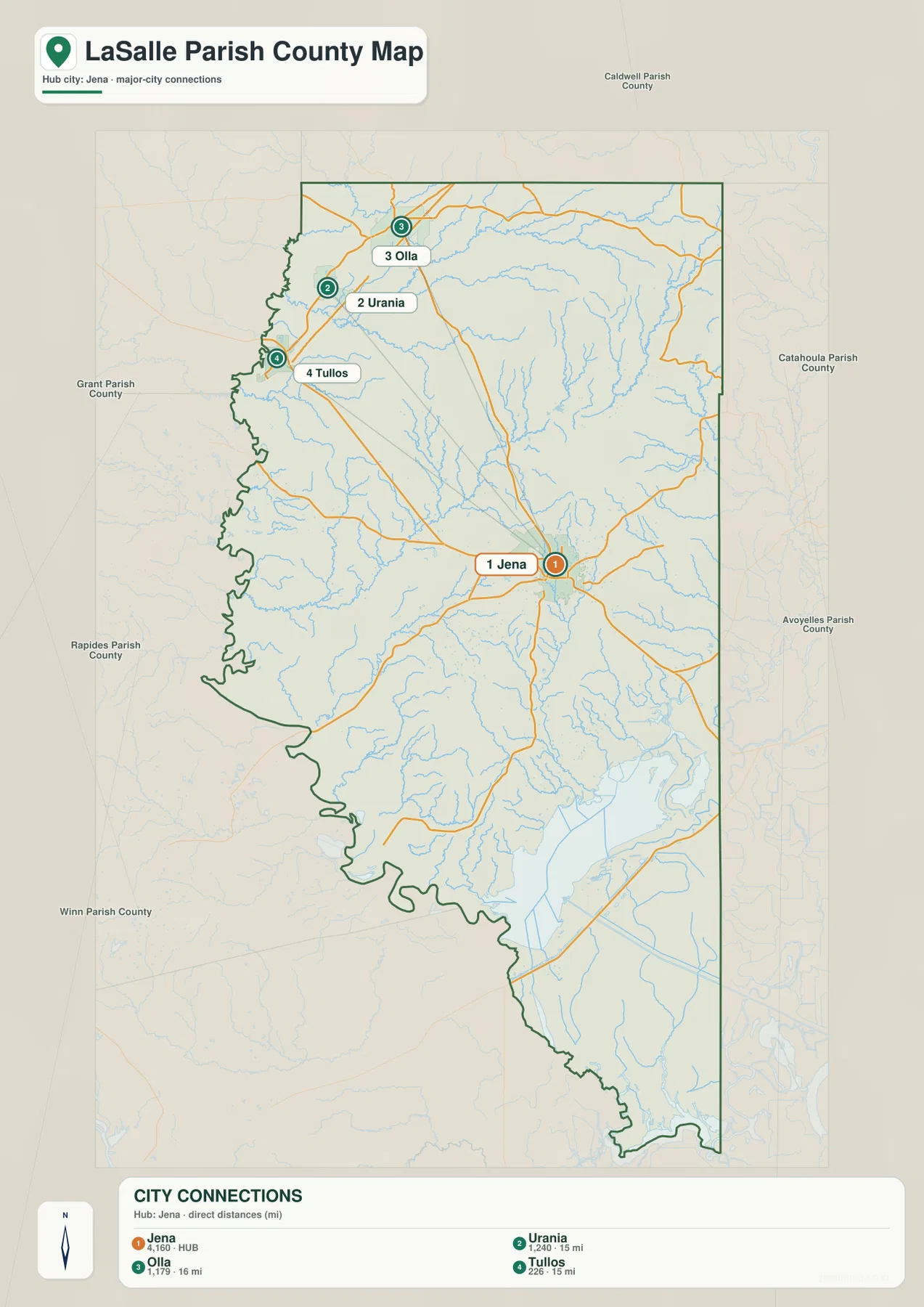
Olla, Urania, and Tullos sit about 15–16 miles from the Jena hub
The city-connections map reduces the parish to four labeled places. Jena is the number 1 hub, Urania is number 2, Olla number 3, and Tullos number 4. The legend gives direct distances of about 15 miles from Jena to Urania, 16 miles to Olla, and 15 miles to Tullos. These are straight-line distances between the mapped locations, not driving mileage along U.S. 84, U.S. 165, or local roads.
The pattern is more revealing than the one-mile difference among the numbers. All three secondary towns occupy the same broad northwestern direction from Jena, but they are not stacked on one exact line: Tullos is farther west, Urania lies northeast of it, and Olla sits farther north. The graphic therefore gives a quick sense of how the parish’s main communities are divided between the Jena area and a compact northwestern group. That simplified relationship is useful when the full road map contains more detail than a presentation or lesson needs.
Bayou Funny Louis crosses a dense network of central streams
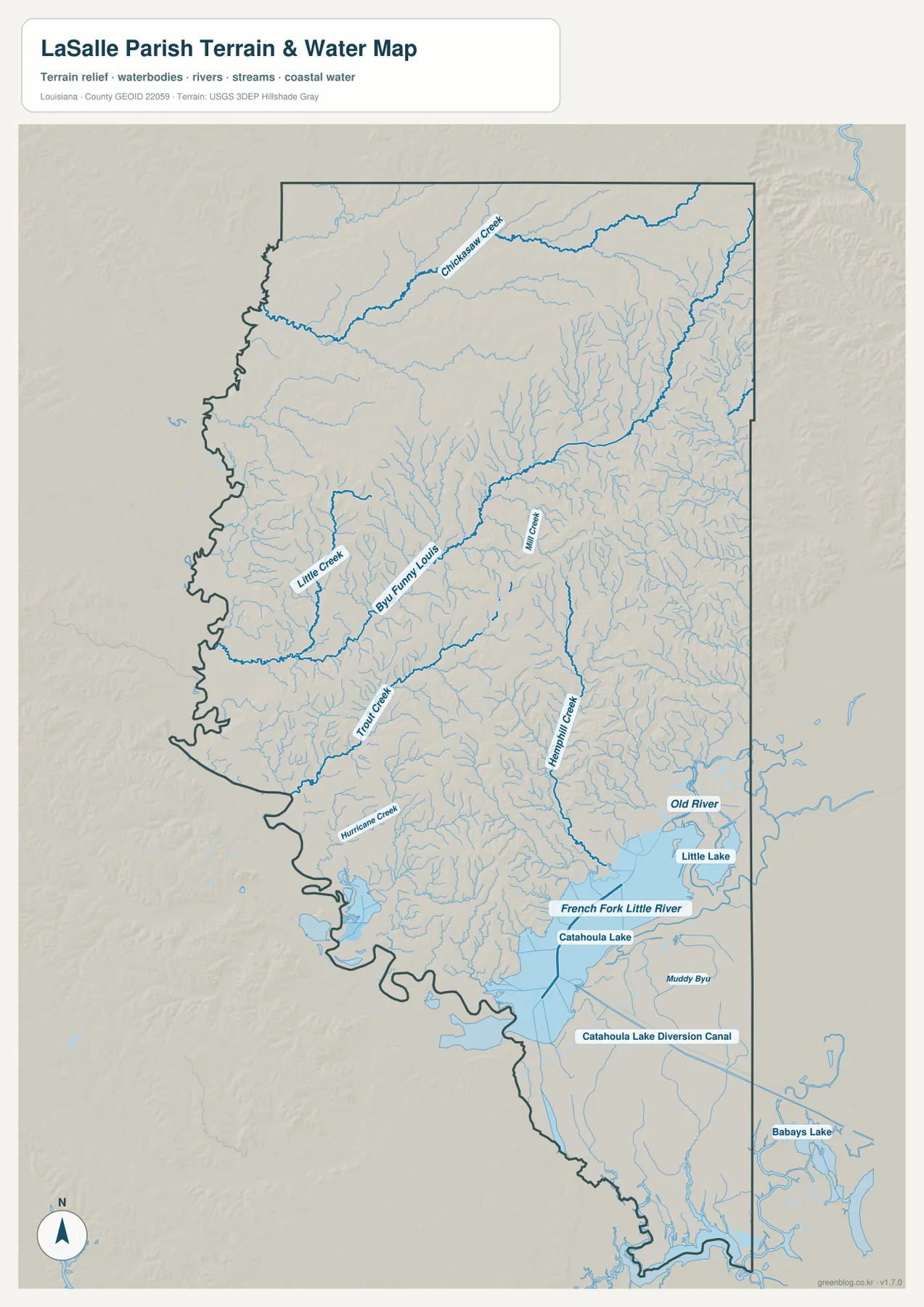
The terrain-and-water map removes most road distractions and makes the drainage pattern much more obvious. Bayou Funny Louis is one of the longest labeled waterways through the middle of the parish, extending across the central section while numerous smaller tributaries feed into or run near it. Little Creek and Trout Creek are labeled to the west and southwest of the central bayou, while Mill Creek appears closer to the middle. Little Chickasaw Creek forms another long reference feature across the northern part of the parish.
Hemphill Creek is prominent in the eastern half, descending through a dense field of smaller channels. The number of thin blue lines is important because it shows that the named creeks are only the larger landmarks within a much more extensive drainage network. The map is designed to show relative position and connectivity, not stream discharge or channel depth. It should therefore be read as a geographic water reference rather than a substitute for hydrologic measurements or navigation information.
Catahoula Lake changes the character of the southern parish
The southern water pattern differs sharply from the creek-dominated center. Catahoula Lake occupies a large area near the southeast, with Old River and Little Lake labeled above it. French Fork Little River reaches toward the lake area, and the Catahoula Lake Diversion Canal is marked farther south. This combination of lake water, river channels, and constructed canal features gives the lower parish a broader and more open water landscape than the tightly branched streams around Bayou Funny Louis.
That change helps explain why the three supplied maps complement one another. Olla and Urania are easiest to understand through settlements and roads; Jena is best recognized as a road and community hub; the far south is easier to interpret through water features and the irregular parish edge. A reader who looks only at the city map would miss most of this southern geography, while the water map alone would not show why Jena and the northwestern towns matter as orientation points.
Different landmarks work better in different parts of LaSalle Parish
For settlement questions, begin with Jena and Midway, then trace U.S. 84 toward Tullos and the northwestern towns. For broader road orientation, U.S. 84 and U.S. 165 are the easiest numbered highways to recognize before moving to the smaller state routes around Jena. Water-focused questions call for a different set of anchors: Bayou Funny Louis in the middle, Little Chickasaw Creek in the north, Hemphill Creek in the east, and Catahoula Lake in the south.
This approach is also useful on smaller screens. Instead of trying to read every label at once, locate the relevant section and then enlarge the original map. The Olla–Urania–Tullos cluster, the dense intersections around Jena, and the small channels near Catahoula Lake contain enough detail that a high-resolution image is easier to inspect than the web preview. For classroom or presentation use, separating the settlement-and-road story from the water story also keeps the explanation clearer.
High-resolution JPG files keep the small labels readable
The downloadable ZIP contains the original JPG versions corresponding to the three previews on this page: the general parish map, the city-connections map, and the terrain-and-water map. Each original image is 2572 by 3638 pixels, giving more room to enlarge road numbers, town labels, creek names, and the detailed southern shoreline. The originals are practical for printing, classroom material, presentation slides, and personal geographic reference.
Use the general map when you need communities, roads, and the parish boundary in one view. The city-connections version is the clearest choice for a quick comparison of Jena with Olla, Urania, and Tullos. Choose the water map when Bayou Funny Louis, the creek network, Catahoula Lake, or the diversion canal is the main subject. None of these maps should replace current legal boundary records, surveying, live traffic information, flood-hazard products, or navigation charts.
Frequently Asked Questions
What is the best place to start when locating communities in LaSalle Parish?
Start with Jena, the parish seat and the main hub on the supplied maps. Louisiana’s official parish profile also lists Olla, Tullos, and Urania as municipalities, while Midway appears immediately west of Jena. From Jena, the three northwestern towns form a clear second group that is easy to follow on the general map.
Are the 15- and 16-mile labels from Jena driving distances?
No. The city-connections map uses straight-line distances from the Jena hub: about 15 miles to Urania, 16 miles to Olla, and 15 miles to Tullos. Actual driving distance depends on the chosen roads and exact starting point, so current navigation information is better for trip planning.
Can the Catahoula Lake water map be used for flood or boating decisions?
No. It is a general geographic reference showing the relative positions of Catahoula Lake, Bayou Funny Louis, French Fork Little River, and other waterways. It does not provide flood-zone ratings, water depth, navigability, levee protection, or legal property boundaries. Those decisions require current specialized information from the responsible agencies.
Map File Information
The ZIP contains the original high-resolution JPG files corresponding to the general parish map, city-connections map, and terrain-and-water map shown on this page.
- Included Files: parish map JPG, city-connections map JPG, terrain-and-water map JPG
Related Maps
Sources and references
For local administrative information, see the Louisiana.gov LaSalle Parish Profile. Official transportation information for the area is available through the Louisiana DOTD LaSalle Parish page. General boundary data are documented by the U.S. Census Bureau TIGER/Line Shapefiles, and national water-feature data are documented through USGS National Hydrography.
Green Map creates custom-edited map images using open geographic data sources such as geoBoundaries, Natural Earth, OpenStreetMap, and government open data. These maps are edited visual materials, not raw data files, and are provided for education, documents, presentations, and graphic reference.