Trego County in northwestern Kansas is centered on WaKeeney, with Collyer and Ogallah providing smaller references along the I-70 and US 40 corridor. US 283 crosses WaKeeney from north to south, while the county’s terrain is divided by three major drainage bands: the Saline River in the north, Big Creek across the middle, and the Smoky Hill River with Cedar Bluff Reservoir in the south. High-resolution map files are available for download in the section below.
This guide follows WaKeeney and Collyer across the road, water, and elevation views, with terrain ranging from about 614 to 798 meters. WebP previews are available for quick viewing, and the matching high-resolution JPG files can be downloaded together in one ZIP for printing, classroom work, or offline reference.
Table of Contents
WaKeeney anchors the county where I-70, US 40, and US 283 meet
WaKeeney sits in the north-central part of Trego County where Interstate 70 and US 40 form the main east–west corridor and US 283 provides the principal north–south route. Rail lines and local streets concentrate around the same community, making WaKeeney the clearest orientation point for the rest of the county.
The Kansas Historical Society records that WaKeeney became the temporary county seat when Trego County organized in 1879 and then won the election to become the permanent seat. The modern map reflects that role through the concentration of roads, rail, and civic facilities around the town.
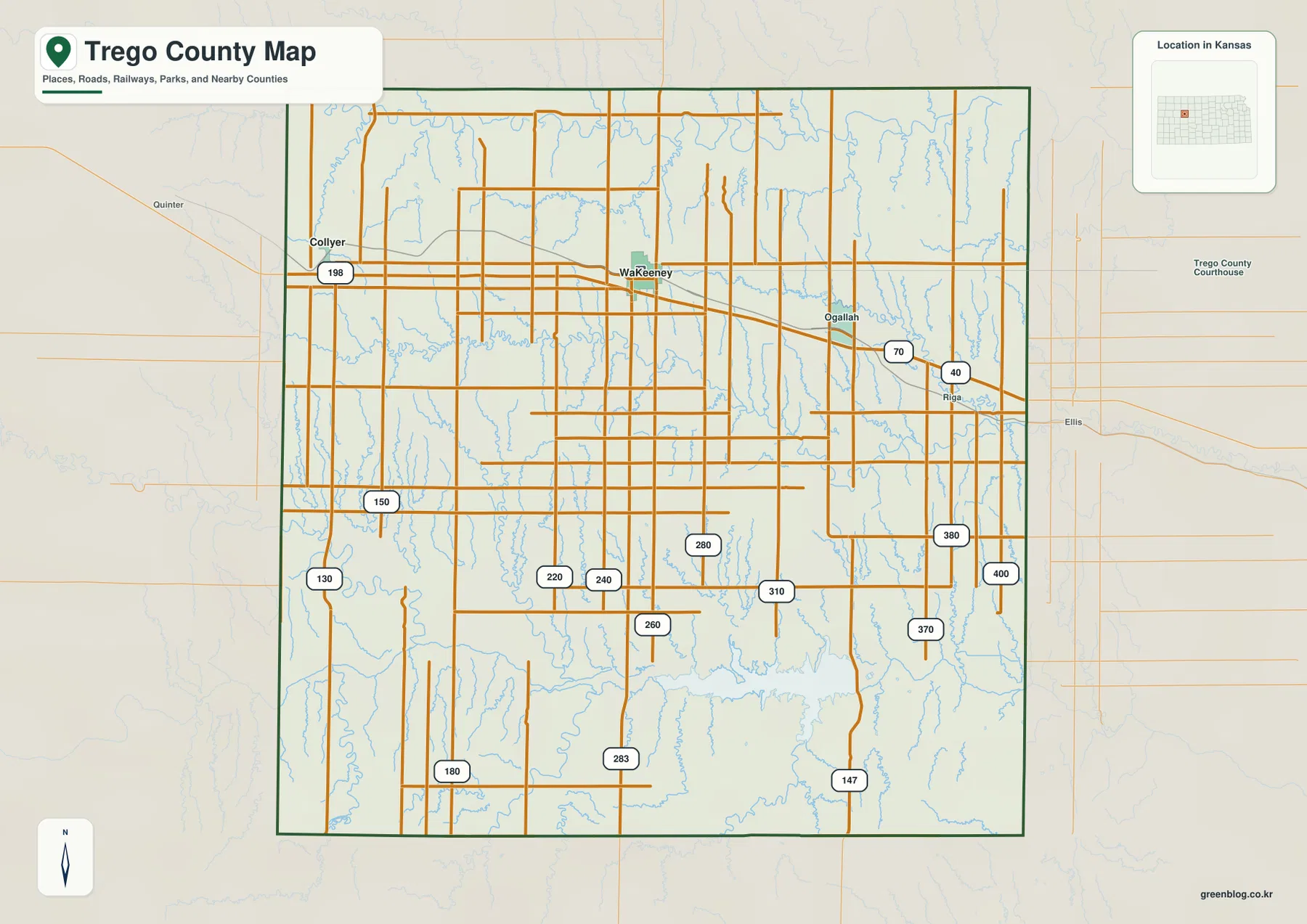
Collyer lies to the west on the same I-70 and US 40 corridor, while Ogallah lies east of WaKeeney. South of the interstate, settlement becomes sparse and the most useful references shift from towns to numbered roads, creek valleys, and the Smoky Hill River country.
Only WaKeeney and Collyer appear on the ranked city panel
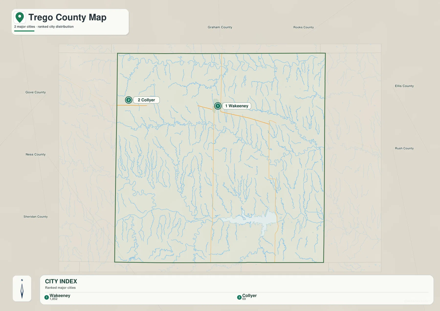
The city panel lists WaKeeney at 1,852 and Collyer at 69. These are map index values rather than current official population estimates, but they show how strongly settlement is concentrated around WaKeeney.
The two communities share the same east–west transportation corridor but occupy very different roles. WaKeeney includes the US 283 junction, county government, rail access, and the largest built-up area, while Collyer serves as a small western reference in an otherwise rural landscape.
Kansas Historical Society census material also shows the WaKeeney area as the county’s principal population center. The census figures and the supplied map index are different datasets and should not be treated as interchangeable, but both reflect the same settlement pattern.
Three major drainage bands divide the county from north to south
The Saline River forms the strongest northern water corridor. Saline Creek, Trego Creek, Shaw Creek, and numerous shorter tributaries descend through the northern hills toward the river, creating a low band near the top of the county.
Big Creek creates a separate central valley that stretches from west to east across much of Trego County. Spring Creek joins the system in the east, while Downer Creek and many smaller channels cut southward through higher terrain. This middle drainage is visually distinct from both the Saline River and the Smoky Hill River.
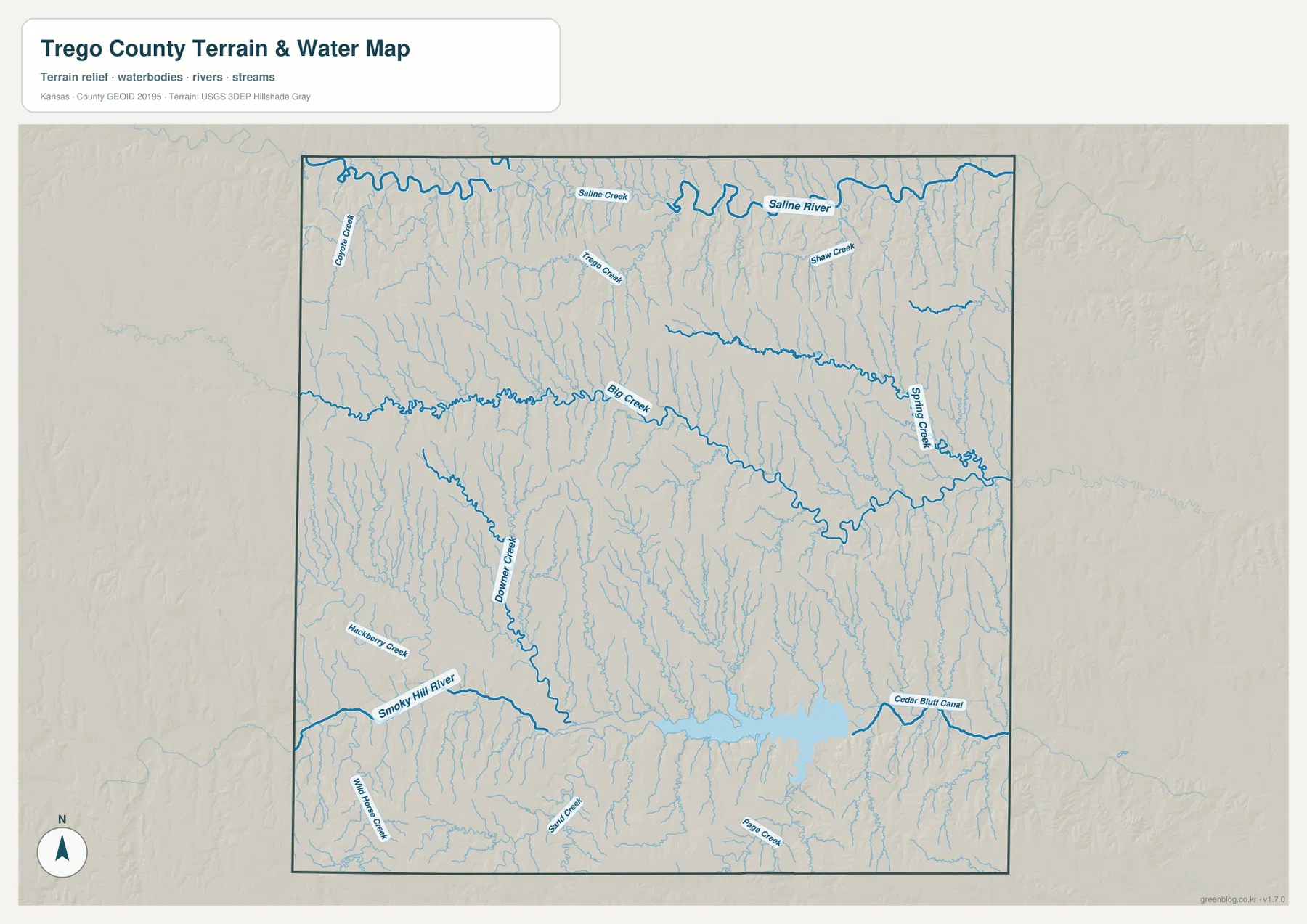
In the south, the Smoky Hill River enters a broad low corridor and feeds Cedar Bluff Reservoir. Hackberry Creek, Wild Horse Creek, Sand Creek, Page Creek, and numerous unnamed channels descend from the surrounding uplands toward the river and reservoir.
This water image is intended for geographic reference rather than floodplain, navigation, water-quality, parcel, or legal-access decisions. Reservoir level and stream conditions can change, so current agency information should be used whenever access or safety matters.
Elevation from 614 to 798 meters separates western uplands from river and reservoir lowlands
The elevation surface ranges from about 614 to 798 meters, with a mean near 713 meters. Brown and tan high ground dominates much of the west and northwest, while greener low terrain becomes more extensive toward the east and along the major drainage corridors.
The Saline River appears as a lower band in the north, but higher ridges return immediately to the south before Big Creek forms a second low corridor across the middle. Farther south, the Smoky Hill River and Cedar Bluff Reservoir occupy some of the county’s lowest continuous terrain.
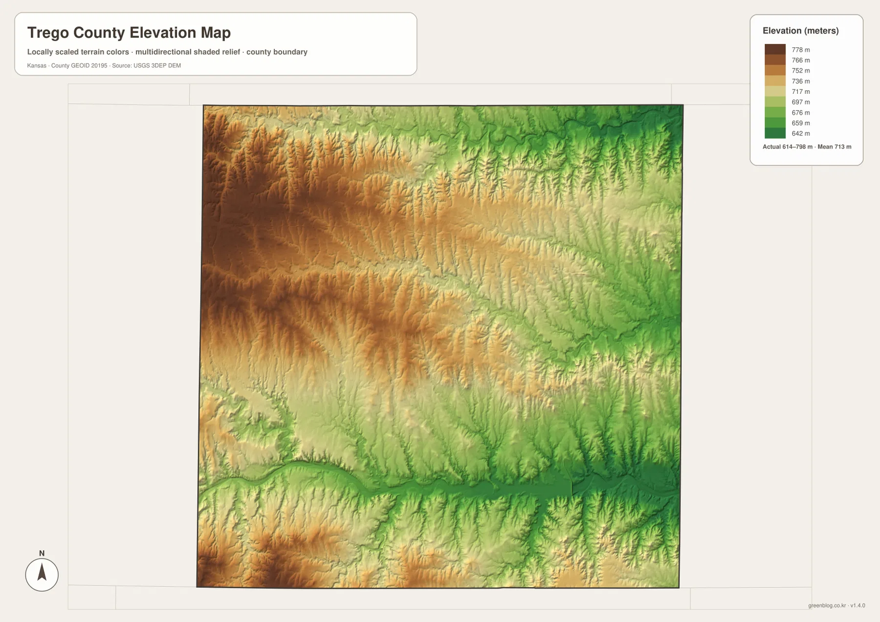
WaKeeney lies on middle-elevation uplands rather than the lowest river floor. Collyer and the western interior are generally higher, while the route south toward Cedar Bluff drops through repeated creek valleys into the broader Smoky Hill lowland.
The elevation surface is generalized for county-scale comparison. It is not survey-grade or engineering-grade measurement and should not be used for parcel elevations, construction grades, drainage design, or legal boundary work.
Cedar Bluff State Park gives the southern reservoir landscape a clear real-world reference
Kansas Department of Wildlife and Parks manages Cedar Bluff State Park in two areas along Cedar Bluff Reservoir. The north-shore Bluffton Area covers nearly 350 acres and contains the more developed collection of campsites, boat ramps, shelters, cabins, and beach access.
The Kansas Historical Society notes that Cedar Bluff Reservoir was built on the Smoky Hill River in 1949. On the supplied maps, the reservoir’s broad water surface sits inside a distinctly lower valley surrounded by tributary-cut hills, making it one of the easiest places to connect the road, water, and elevation views.
Butterfield Overland Dispatch and the Smoky Hills Trail crossed the same rugged country
Kansas Historical Society material records both the Butterfield Overland Dispatch and the Smoky Hills Trail through Trego County. Fort Downer began as a stage station and briefly became a military post, while Camp Ogallah was established to protect railroad workers during the 1860s.
Modern travel now follows I-70 and US 40 across the northern part of the county, but older routes depended far more on river crossings, creek valleys, and manageable grades. The repeated ridges between the Saline, Big Creek, and Smoky Hill systems help explain why specific passes and travel corridors mattered before modern highways.
A trip from Collyer through WaKeeney to Cedar Bluff crosses the county’s main terrain zones
Traveling east from Collyer to WaKeeney follows the high northern transportation corridor. Turning south from WaKeeney then crosses the Big Creek drainage and a series of tributary-cut hills before reaching the lower Smoky Hill River and Cedar Bluff Reservoir landscape.
That route is especially useful for comparing the four supplied map views because it links the county’s two ranked communities, main highway junction, central drainage, and largest water body in one continuous geographic sequence.
For posters, classroom prints, or presentation slides, use the original JPG files in the download archive rather than enlarging the web previews. Small road labels, creek names, town text, and the elevation legend remain clearer at the higher resolution.
Frequently Asked Questions
Why does the city map show only WaKeeney and Collyer?
The supplied ranked-city dataset contains two entries for Trego County: WaKeeney at 1,852 and Collyer at 69. Other place names can appear on the general map, but only these two communities are included in the city ranking panel.
Which river feeds Cedar Bluff Reservoir?
Cedar Bluff Reservoir is built on the Smoky Hill River in the southern part of Trego County. The water map shows the river entering the broad reservoir valley, with several tributaries descending from the surrounding uplands.
Can the 614–798 meter elevation image be used for surveying?
No. It is a generalized county-scale terrain image for comparing higher uplands with lower river and reservoir valleys. Parcel elevations, engineering grades, drainage design, and legal boundary work require more precise official data and, where needed, professional surveying.
Map File Information
The archive contains the Trego County, Kansas general county map, city map, terrain-and-water map, and elevation map as original high-resolution JPG files.
- Included Files: Use only the versions confirmed in the article and supplied images
- File Type: Use the confirmed download contents
- Intended Use: Printing, education, presentations, and map-based projects
Related Maps
Sources and references
- Kansas Historical Society: Trego County, Kansas — county seat, Cedar Bluff Reservoir, historic trails, and local history
- Kansas Department of Wildlife and Parks: Cedar Bluff State Park — reservoir, park areas, and visitor information
- U.S. Census Bureau TIGER/Line Shapefiles — county boundary and geographic reference data
- USGS National Hydrography — river and stream reference data
- USGS 3D Elevation Program — elevation and terrain reference data
Green Map creates custom-edited map images using open geographic data sources such as geoBoundaries, Natural Earth, OpenStreetMap, and government open data. These maps are edited visual materials, not raw data files, and are provided for education, documents, presentations, and graphic reference.